Hands on with the Magellan eXplorist 510
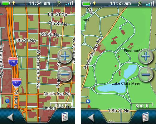
The Magellan eXplorist 510 is a mid-range model in Magellan’s handheld line. Like the eXplorist 610 and 710, this model sports a bright 3.0” color touchscreen and 3.2 MP geotagging camera, along with a microphone and speaker for field notes. All three units have a micro-SD slot for memory expansion, are set up for paperless geocaching, and come with a pre-loaded “World Edition” basemap that features a full road network for the US, Canada, Western Europe and Australia.
Quick links
More Magellan eXplorist 510 reviews
Magellan eXplorist 510 resources
How much does it cost?
Related units
- Step up to the eXplorist 610 to gain an electronic compass, barometric altimer and preloaded topo maps
- Or grab the top of the line eXplorist 710 to get turn-by-turn directions
- There are also eXplorist 510 Marine
, Angler
and Summit Series Topo
editions available; Hunter and National Geographic Topo versions are expected soon
World Edition basemap
National Geographic Topos
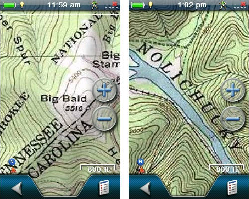
While I had the 510, I made it a point to try out Magellan’s new National Geographic Topo maps, which are available via a $29.99 12 month subscription. Follow that link to learn more; screenshots below.
Magellan eXplorist 510 interface
The eXplorist x10 series offers a number of innovative features. The most prominent being the…
Four corners menu
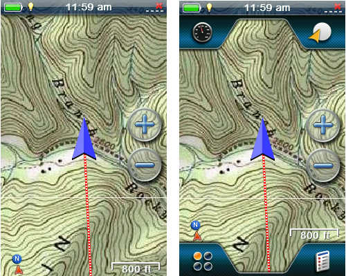
Many handheld GPS users spend most of their time on the map screen, and Magellan has made this the center of their new interface. Simply touch the map screen to bring up the four corners menu, shown below at right.
Lets look at each of the four corner icons…
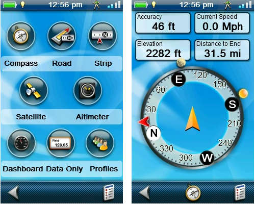
Dashboards (upper left) – Rather than change the top portion of the screen (ala Garmin dashboards), this icon brings up various pages. It can be customized so that touching it brings up one of the screens whose icons are pictured below, at left. For example, the compass screen is shown at right. The lower center icon on this page allows you to switch which “dashboard” appears when you press the upper left four corners icon.
The lower right icon on each of the pages below brings up a context sensitive options menu, allowing you to do things like alter the number of data fields, reset the trip odometer, etc.
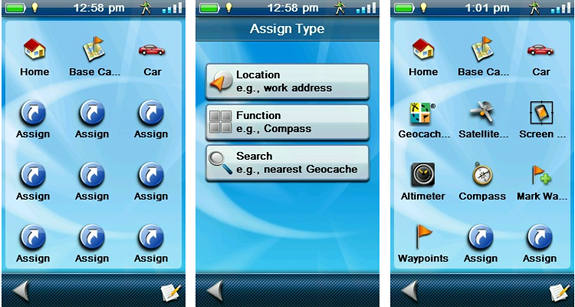
OneTouch (upper right) – The OneTouch menu is shown below at left. Nine icons can be assigned specific shortcuts; options for these are shown in the center image. The screenshot on the right shows what it looked like after I did some customization.
Magellan eXplorist 510 OneTouch menu customization
The Function option allows you to set a shortcut to screens such as the compass, altimeter, trip summary, etc. The Location option works for specific waypoints, POIs, geocaches, etc. The Search option allows you to place a shortcut for filtered groups of waypoints, geocaches, etc. (you can also set it to display the nearest). I thought the Camp and Car icons were pretty useless, since those locations will always be changing. But all you need to do is press the edit icon in the lower right hand corner, tap the car or camp icon, and you’re asked if you want to reassign it to your current location. Nice. One thing I would like to see added is a Change Profile function option.
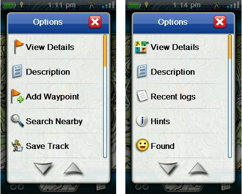
Options menu (lower right) – Continuing clockwise on the four corners menu, we come to Options, which is context sensitive. Shown below are a couple of examples.
The main menu
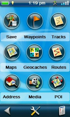
Main menu (lower left) – Tapping the main menu icon brings up the screen shown at left.
Functionality of the Four Corners interface
The four corners menu works very well. Tap the map to bring it up, tap it again to hide it. Instead of tapping the map, if you drag your finger across it, you’ll enter pan mode. Now you can tap the map to display information about a point on the map, a POI, etc.
I have to say, the four corners idea seems well thought out. Combined with the OneTouch menu, few critical items need be more than a couple taps away. The interface is intuitive enough that I rarely referred to the manual during my testing – which is not always the case when I try out a new unit.
Even so, there is one downside. By providing access to things like Map Options from multiple places in the interface, it can lead to confusion. And handheld GPS receivers are already complex beasts. Overall though, I do like the interface.
Save and Start
Data field options
In the Main Menu shot above at left, you see a Save icon, allowing you to save your active track. Once you do that, the icon becomes a Start button. Press it and you are asked if you want to clear the active track and start a new track. This makes it really easy to start a new track at the trailhead – very intuitive.
Interface odds & ends
A few comments on the interface, some good and some bad:
- When navigating to a waypoint, the distance is given in feet below one mile, so instead of showing .20 miles, you’ll see 1056’ to go
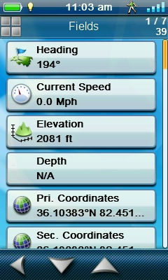
- When you tap a data field to change it, live data is shown for each field in the field selection screen (see screenshot at right) – nice!
- Unfortunately, they aren’t in alphabetical order
- Captured screenshots can be viewed on the unit
- The only “reposition here” option to relocate a waypoint in the field is a calculate position (waypoint averaging) feature that takes 60 seconds to complete
- There is a “pause track” function; thank you Magellan!
Magellan eXplorist 510 hardware
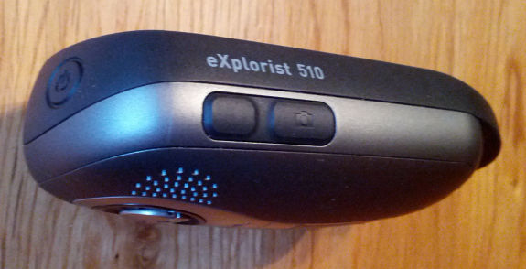
The unit’s interface isn’t 100% touchscreen. There are three buttons on it – power (on top) and mark waypoint and camera buttons on the side. The latter two can be customized, choosing from 29 possible options.
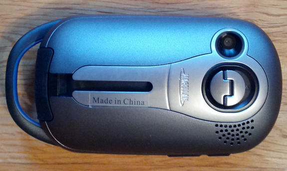
The eXplorist 510 feels solid and well built. On the back (below), you can see the battery compartment latch, camera, speaker, mini-USB port flap (at bottom), handy spot for attaching a lanyard, and a metal slot for a mount. A few comments… The battery compartment latch turns 90 degrees to open, is easy to use and feels like it securely latches the compartment. The mini-USB port is at an angle, which you may find awkward at first, but should quickly get used to. The metal strip surrounding the mount slot and camera is more problematic. While the rest of the back is made of a slightly grippy material, the metal portion makes it easy for the unit to move around when set down. Set it on a rock and watch it slide!
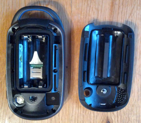
The inside reveals a seal around the battery compartment, which is where the microSD card slot is located.
The eXplorist 510 has 2GB of internal memory (500 MB available for the user).
Camera
The 3.2 MP camera geotags photos with location info. Now I’m not the greatest photographer, but I did take some sample shots. You can click on the image below to see a full uncompressed version.
So that’s the still camera, but you can also shoot videos with the eXplorist 510, although they only go up to 320 x 240, so don’t plan on entering Sundance with it.
Voice recorder
A test of the voice recorder showed it to be adequate for field notes. Playback volume was low, but loud enough to be understood. Voice notes can be attached to a waypoint, geocache, track or route.
Paperless geocaching
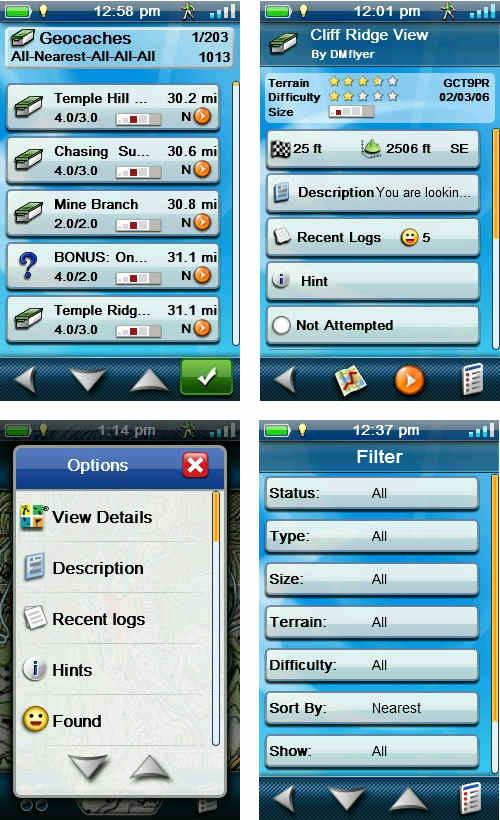
The eXplorist 510, like all the new eXplorists, is set up for paperless geocaching. Shown below (clockwise from top left) is a list of nearest caches, individual cache screen, filters and the options menu.
A few geocaching notes:
- To display all geocaches on the map, you need to go into map settings and enable it. And it’s an all or nothing; filtering caches doesn’t change the map display
- While geocache details are available from the map screen via the option menu, they are not available from the compass screen
- The compass can be overlaid on the map screen
Performance
Magellan eXplorist 510 pros
- Easy access to most features via four corners interface
- Extensive customization options reduce the number of steps required to access features
- Extensive world-wide basemap
- Good battery life
- Sturdy, well-built hardware
- Paperless geocaching
- Geotagging camera
- Voice recorder
Magellan eXplorist 510 cons
- Metal on back can lead to unit sliding when set down on a sloped surface
- Multiple ways to access features can make interface confusing
Magellan eXplorist 510 recommendation
Recommended. This is probably the best Magellan handheld I’ve ever used. It seems that most of the few bugs and complaints I had about the 710 I tested in early 2011 have been resolved. With its preloaded basemap it is an excellent choice for urban geocachers, and the addition of maps like National Geographic topos make it a great backcountry navigator as well.
More Magellan eXplorist 510 reviews
- Consumer-authored Magellan eXplorist 510 reviews
have been posted at Amazon
- Geek.com reviews the eXplorist 510
- Outdoor Gear TV’s video review
- Gear Diary has posted an eXplorist 510 review
- A user review of the eXplorist 510 marine edition
- OceanMountainSky has posted a detailed Magellan eXplorist 510 review; here is their video review:
Other Magellan eXplorist 510 resources
- The Magellan eXplorist 510 owners manual
- Some Magellan eXplorist 510 FAQs
- A Magellan eXplorist series message forum
- The official Magellan eXplorist 510 web page
Compare prices on the Magellan eXplorist 510 at these merchants:
- Check the current Magellan eXplorist 510
price at Amazon
- Get the Magellan eXplorist 510 Hand Held GPS Receiver
at TigerGPS
- You can also buy the Magellan eXplorist 510 Handheld GPS Unit
at BassPro.com
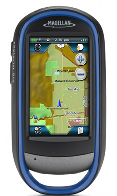



What is at the bottom of the device? A handle? What is its purpose? Looks to me like excess space and weight.
Can the NiMH batteries be recharged in the unit? I’ve found value of my Delorme PN-40 recharging the Lithium-Ion batteries via AC, DC, or USB. Great for travel.
Like to see a comparison review with different planning software.
I used it for attaching a lanyard. Perhaps it provides some structural rigidity or protects the bottom flap/USB connection in case of drops.
No, you can’t recharge the batteries while in the unit.
Rich,
How do you capture such excellent quality screen shots?
Blake
Many newer models have built-in screen capture capabilities. Nice site, BTW!
just purchased megallan 610 and cant figure out how to manually put in coordinates. Is this possible for this gps?
The procedure for most models is to mark a waypoint (at your current location) and then edit the coordinates. If that doesn’t work for you, let me know and I’ll investigate further.
I have been using the eXplorist 310 for a few years now. I’ll admit it was a pain to get used to but it works great. I don’t see the need in upgrading until something mind blowing comes out. I’m not sure I trust touch screens mixing with rugged terrain and water…
I just purchased the 510 Marine Edition. I notice that when the pre-installed world base map is checked at the same time the sd card Navionics marine map is checked, then the base map does not display any streets other than major freeways. When I uncheck the sd card Navionics map, then the detail on the pre-installed world base map returns. Is this normal or is there something wrong with my unit?
One map probably layers over the other, leaving the other one invisible.
When searching for geocaches on the Magellan Explorist 520, did you use the compass on the upper left corner of the map or is there a better way? Nice review!
*510
I believe you can also either use the compass screen or overlay the compass on the map screen.
I am hiking the Appalachian Trail in a couple of weeks and I just placed order for the 510 online, I am sure there will be lots of Geocaches along the trail, however, What is the best gps map for navigating through the trail and finding places of interest?
Probably one of these: http://www.magellangps.com/Store/Summit-Series
I have a magellan explorist 510, its doing my head in trying to put in coordinates. When I try to change the co-ords to something like S 37 49.675 it brings up an invalid input message, saying, valid only from 0.00 to 60.00. Do I have the settings wrong?? I have tried changing all sorts of things, have downloaded software upgrade to no avail. Also on changing and saving coords that appear to have gone in, on accessing them, they appear not to have changed at all. I love my magellan, but this is preventing me from doing multis and puzzles with my geocaching, hoping someone can help.
Rich,
Do you think this GPS works in Asia, especially my county, Indonesia? I find out that a lot of GPS brands don’t work well here. I mean the maps, traffic, sometimes it goes wrong and gives wrong direction. Thank you.
3 Units all failed software updates, from V.13
Last Unit,
Once again, Returned the unit to store from which is was bought, Store replace, tried re downloading the update. Installing through vantage point whilst at the shop of purchase. Returned unit number 3 for a full refund. However, this does mean that I lost valuable data collected from my last 3 trips, Saved way points, Routes, and Tracks, Which now need to be remapped out.
Will not recommend to any one else, Mother in law purchased one in recommendation by myself which has also been returned after a failed update.
I do believe this is a shame as it was a promising unit having many of the features I was after.
Unfortunately, Due to being unstable on software. I doubt at this current stage that I would be likely to attempt another.
Regards
Simon
don’t buy one !!!! most have a battery drain fault that magellan won’t fix it’s on the PCB and effects 510 610 710 randomly and it will get you stuck in the middle of nowhere !!!! take them back while you have warranty and it’s not the suspend mode or the screen capture .