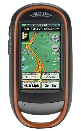
Magellan reinvents the handheld GPS interface
The Magellan eXplorist 710 is the top of the line unit in Magellan’s new eXplorist x10 series, offering a preloaded topo map and turn-by-turn directions, allowing it to serve as a dual-purpose unit. It also includes a barometric altimeter and tri-axial electronic compass.
Like the eXplorist 510 and 610, this model sports a 3.0” touchscreen and 3.2 MP geotagging camera, along with a microphone and speaker for field notes. All three units have a micro-SD slot for memory expansion, are set up for paperless geocaching, and come with a pre-loaded “World Edition” basemap that features a full road network for the US, Canada, Western Europe and Australia.
Quick links
More Magellan eXplorist 710 reviews
Magellan eXplorist 710 resources
How much does it cost?
Related models
- Drop down to the eXplorist 610 and you’ll give up the turn-by-turn directions
- Going further down the product line, the eXplorist 510 drops the electronic compass, barometric altimeter and preloaded topos.
Magellan eXplorist 710 interface
The eXplorist x10 series offers a number of innovative features. The most prominent is the…
Four corners menu
Many handheld GPS users spend most of their time on the map screen, so Magellan has made this the center of their new interface. Simply touch the map screen to bring up the four corners menu, shown below at right.
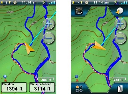
Lets look at each of the four corner icons…
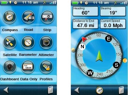
Dashboards (upper left) – Rather than change the top portion of the screen (ala Garmin dashboards), this icon brings up various pages. It can be customized so that touching it brings up one of the screens whose icons are pictured below, at left. For example, the compass screen is shown at right. The lower center icon on this page allows you to switch which “dashboard” appears when you press the upper left four corners icon.
The lower right icon on each of the pages below brings up a context sensitive options menu, allowing you to do things like calibrate the compass, alter the number of data fields, reset the trip odometer, etc.
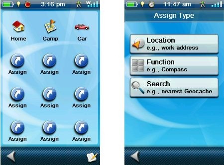
OneTouch (upper right) – The OneTouch menu is shown below at left. Nine icons can be assigned specific shortcuts; options for these are shown at right. I found the Function option the most useful, which allows you to set a shortcut to screens such as the compass, altimeter, trip summary, etc. The Location option works for specific waypoints, POIs, geocaches, etc. The Search option allows you to place a shortcut for filtered groups of waypoints, geocaches, etc. I thought the Camp and Car icons were pretty useless, since those locations will always be changing. But all you need to do is press the edit icon in the lower right hand corner, tap the car or camp icon, and you’re asked if you want to reassign it to your current location. Nice.
Options menu (lower right) – Continuing clockwise on the four corners menu, we come to Options, which is context sensitive. Shown below are a couple of examples.
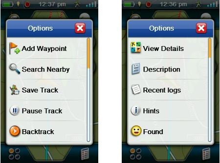
This actually brings up one of the few complaints I have about the interface. A wider slider bar would assist scrolling. But you can also move through a list by touching and holding a menu item, then dragging the list up or down. It works okay, albeit slowly. Navigating these sliding menus is one of the few clunky parts of an otherwise excellent interface.
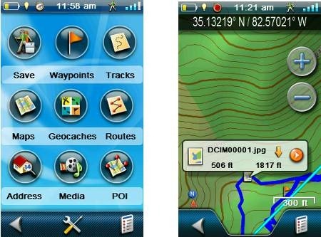
Main menu (lower left) – Tapping the main menu icon brings up the screen shown below, at left.
A quick video tour of the interface:
Functionality of Four Corners
The four corners menu works very well. Tap the map to bring it up, tap it again to hide it. Instead of tapping the map, if you drag your finger across it, you’ll enter pan mode. Now you can tap the map to display information about a point on the map, a POI or, as seen above at right, a photo location. Tap the left side of an information bubble for more details; tap the arrow to route to the location. The back button at the bottom left of the screen exits pan mode and returns you to your current location on the map.
I have to say, the four corners idea seems well thought out. Combined with the OneTouch menu, few critical items need be more than a couple taps away. The interface is intuitive enough that I rarely referred to the manual during my testing – which is not always the case when I try out a new platform.
Save and Start
In the Main Menu shot above, at left, you see a Save icon, allowing you to save your active track. Once you do that, the icon becomes a Start button. Press it and you are asked if you want to clear the active track and start a new track. This makes it really easy to start a new track at the trailhead – very intuitive.
Interface odds & ends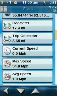
A few comments on the interface, some good and some bad:
- When navigating to a waypoint, the distance is given in feet below one mile, so instead of showing .20 miles, you’ll see 1056’ to go
- Auto-zooming of the map is enabled by default – very annoying
- When you tap a data field to change it, live data is shown for each field in the field selection screen (see screenshot at right) – nice!
- Unfortunately, they aren’t in alphabetical order
- Captured screenshots can be viewed on the unit
- There is no “reposition here” option to relocate a waypoint in the field (though I’ve been told this slated for a future firmware update)
- There is a “pause track” function
- Track names aren’t shown when tracks are transferred to the unit – instead you get something like TRK3; these can be edited on the unit, but that’s far from ideal
Magellan eXplorist 710 hardware
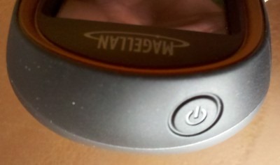
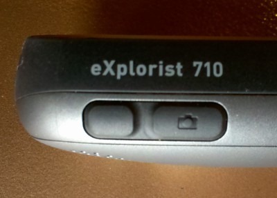
The unit’s interface isn’t 100% touchscreen. There are three buttons on it – power (on top) and mark waypoint and camera buttons on the side. The latter two can be customized, choosing from 26 possible options.
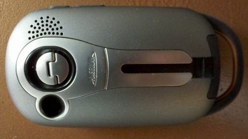
 The eXplorist 710 feels solid and well built. On the back (below), you can see the battery compartment latch, camera, speaker, mini-USB port flap (at bottom), handy spot for attaching a lanyard, and a metal slot for a mount. A few comments… The battery compartment latch turns 90 degrees to open, is easy to use and feels like it securely latches the compartment. The mini-USB port is at an angle, which you may find awkward at first, but should quickly get used to. The metal strip surrounding the mount slot and camera is more problematic. While the rest of the back is made of a slightly grippy material, the metal portion makes it easy for the unit to move around when set down. Set it on a rock and watch it slide!
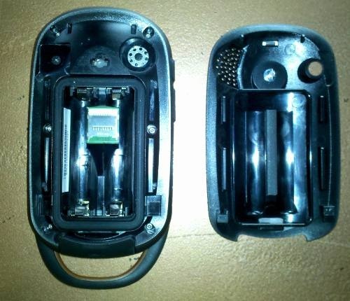
The inside reveals a seal around the battery compartment, which is where the microSD card slot is located.
The specs say that the eXplorist 710 has 3GB of internal memory available for the user, but mine showed nearly 4GB, even after loading some data to the unit. That and the memory card slot leave me wondering what you would load to this unit that comes with topos and road maps. Might there be some official raster / aerial imagery in the eXplorist line’s future?
Magellan eXplorist 710 display
Judging high resolution displays is a very difficult and inherently subjective task. Units perform differently in sunlight and shade and every condition in between, such as indirect bright light. This is compounded by variations between brands in the background color of maps and menu color schemes. So take what I say with a grain of salt…
I compared the eXplorist 710 to the Garmin GPSMAP 60CSx and 62s, the Oregon 450 and the Satmap Active 10 Trek. The eXplorist performed as good or better than all in deep shade and when viewed at the optimum angle in bright sunlight. When checking in bright light for a wide of a range of viewing angles, the eXplorist fell in the middle (60CSx > Oregon 450 > eXplorist 710 > 62s > Satmap).
Lets back up a bit and look at the issues with high-resolution transflective TFT screens. The more pixels the manufacturer packs into a given area, the denser they are, meaning less light can be reflected back to the user. Here’s the breakdown of a few units by pixel density:
- Garmin GPSMAP 62s = 16.7 px/sq. mm.
- Magellan eXplorist 710 = 37.3 px/sq. mm. (estimate – exact screen dimensions not provided by Magellan)
- Garmin Oregon 450 = 40.1 px/sq. mm.
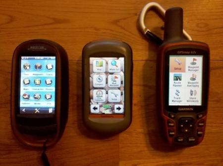
So we can see that this is a fairly high resolution screen, and therefore can expect some visibility issues. And while I won’t attempt to compare visibility in a photo, the image below does give you a good comparison of display sizes, with the eXplorist and Garmin Oregon 450 both offering 3” displays, vs. the 62 series’ 2.6” screen.
Camera
While I don’t claim to be a photographer, I did snap some sample pics and uploaded them to Picasa. A small version of one is posted below, which should give you an idea what kind of winter we’ve been having in the sunny south!

The camera is 3.2MP and can be used in still or video mode. Image size and quality can both be adjusted, and photos can be viewed on the device itself. One other note — the time stamps appear to be based on UTC and not local time.
Voice recorder
A brief test of the voice recorder showed it to be adequate for field notes. Playback volume was low, but loud enough to be understood, unlike the Lowrance Endura Sierra, which has a similar feature. Voice notes can be attached to a waypoint, geocache, track or route.
Maps
The eXplorist 710 comes with three preloaded maps:
Summit Series US topo maps
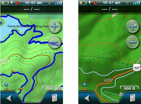
The Summit Series is an excellent topo map, based on 1:24,000 scale data. The only problem I had with them, and it is a significant one, was that contour lines were difficult to see in public land areas, such as in the USFS holdings shown below at right.
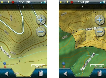
It wasn’t quit as bad for National Park Service land (below right), and was much better for state park lands, below left.
World Edition basemap
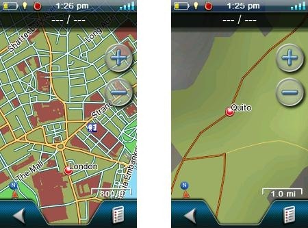
The basemap is one of the best I’ve ever seen on a handheld GPS. It includes much of NAVTEQ’s road network from 200 countries. Still, there appears to be little rhyme or reason to the coverage. Consider the shots below, zoomed to the show the most streets available for London (left) and Quito, Ecuador (right).
City Series
The City Series map allows the device to do turn-by-turn routing, which brings us to…
On the road with the Magellan eXplorist 710
For the geocacher or backcountry adventurer, there are definite advantages to having a handheld that will work as a dual purpose unit. The primary one is that you don’t have to load trailhead locations or geocaches into your handheld and a separate auto unit.
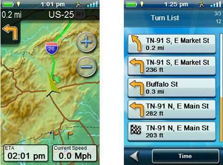
The highway navigation functionality is limited, but it does give voice prompts for turns (though no text-to-speech, meaning it doesn’t call out street names). There are no pop ups showing turn details, but you can see a map overview (below left), and if you tap the next turn indicator, you get a list of turns (below right).
And on the trail
I spent more time on the trail than on the road, and many of my comments about this part of my testing will be found under the performance section below. These are just a couple of odds and ends:
- When you start a trackback, the unit stops recording your current track; this is probably done to reduce confusion, but it should record even if it isn’t displaying, or it could differentiate current track as others do by using a different line type or color
- There is no “waypoint at next” option when navigating a route
Paperless geocaching
The eXplorist 710, like all the new eXplorists, is set up for paperless geocaching. Shown below (clockwise from top left) is a list of nearest caches, individual cache screen, filters and the options menu.
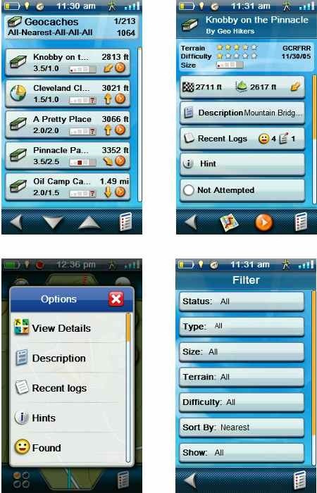
A few geocaching notes:
- To display all geocaches on the map, you need to go into map settings and enable it. And its an all or nothing; filtering caches doesn’t change the map display
- While geocache details are available from the map screen via the option menu, they are not available from the geocache dashboard or compass screen
- The compass can be overlaid on the map screen
Magellan eXplorist 710 performance
Startup time is slow, around 45 seconds, compared to 12 seconds for my Garmin Oregon 450 and 18 seconds for my GPSMAP 62s. Having said that, it usually had locked onto satellites by then.
The unit rebooted on me once while on the trail. Another time, at the end of a hike, I tried to power the unit down and I got a “restarting device to improve performance” message.
Battery life leaves much to be desired. In stationary testing, with the backlight off and track point collection set to every five seconds, I got 7 hours and 10 minutes on freshly charged Eneloops before the unit automatically shut down.
Comparing out and back portions of trackfiles, the eXplorist performed well, usually showing track separation errors of no more than 50’. The unit uses the SiRFstar III chipset, which often reports errant trackpoints (AKA “spidering”), especially when stopped. I did see these, but they were less prevalent than they were with my SiRF III-equipped Garmin 60CSx on the same hikes.
Magellan eXplorist 710 pros
- Innovative, intuitive interface
- Extensive customization options reduce number of steps required to access features
- Preloaded topo maps
- Preloaded highway maps for turn by turn directions
- Extensive world-wide basemap
- Paperless geocaching
- Triaxial compass
- Geotagging camera
- Voice recorder
Magellan eXplorist 710 cons
- Poor battery life
- Contour lines difficult to see in some public land areas
- Lists with slider menus difficult to navigate
- Metal slot on rear makes unit more susceptible to sliding when set down
- Slow to start up
Conclusion
The Magellan eXplorist 710 returns Magellan to the top tier of handheld GPS manufacturers (along with Garmin and DeLorme). The four corners interface is very well thought out, intuitive and reduces the number of steps that plague some other touchscreen models, such as the Garmin Oregon series. The list of significant negatives is short. I don’t know if the contour line issue can be fixed with a firmware update or not. The short battery life will be more of an issue for some than others, though it certainly didn’t seem to hurt sales of the DeLorme PN-40. It’s possible that firmware tweaks may impact this as well. Overall, Magellan has done a very good job, and it’s nice to see a bit more competition and innovation return to the industry.
Addendum
Since posting this review I’ve heard from Magellan. Many of my quibbles are on their update roadmap, or at least being investigated. As for the more significant issues, a contour line visibility fix is slated for the next update. In regards to battery life, they asked if I tested using “Suspend mode,” which turns off everything but tracking. I did not, but this should go a long way towards improving battery life. Their response is indicative of how communicative they’ve been about the new eXplorist line, giving me good access to their team for feedback. I wish all companies were as accessible — just another sign of Magellan’s comeback.
More Magellan eXplorist 710 reviews
- Consumer-authored Magellan eXplorist 710 reviews
have been posted at Amazon
- Geocachers review the eXplorist 710
- Another consumer-authored eXplorist 710 review posted at Groundspeak
- RegHardware gives a 70% rating in their review of the eXplorist 710
- Trusted Reviews give a 9 out 0f 10 rating in their Magellan 710 review
- Expedition Portal has posted their own Magellan eXplorist 710 review
- A brief review from Examiner.com
I’ll be posting more hands on GPS reviews as they appear, but in the meantime, here are some…
Other Magellan eXplorist 710 resources
- The Magellan eXplorist 710 owners manual
- See how the 710 stacks up against other models with this Magellan eXplorist comparison tool
- A Magellan eXplorist message forum
- The official Magellan eXplorist 710 web page
Compare prices on the Magellan eXplorist 710 at these merchants:
- Check the current Magellan eXplorist 710
price at Amazon
- Buy the Magellan eXplorist 710 GPS
at REI.com, where satisfaction is guaranteed and members get 10% back on eligible purchases
- Get the Magellan eXplorist 710 Hand Held GPS Receiver w/ US Street & Topo Maps
at TigerGPS
- Check out the deal on the Magellan eXplorist 710 Handheld GPS Unit
at BassPro.com


Great review Rich. That battery issue is a biggee with me. I dont care what folks say. My Oregon 450 really eats batteries while taking all the precautions. How refreshing it was for me this last weekend to take my old 60csx out and watch my battery bars only drop one point after two full days. And i could actually see the screen to boot. Anyway, hopefully Magellan can tweek battery usage. If these touch screen models have reached their full potential on battery usage, then i suggest manufacturers switch to a lithium ion rechargeable pack ala Garmin Rino 530 so that we can use these things for a few days without worrying about dead batteries. I for one dont mind the extra weight that comes along with extra life. Thanks again.
I have recently returned my 710 and was disappointed that it will be fixed rather than I be offered a refund. In my view it is junk and grossly oversold. It eats batteries. I am based in Australia and it came pre loaded with bad Australian and NZ maps and I was told it had world maps. Well yes but the map for Japan where I was bound for was a mere smudge and you cannot buy an upgrade. It now turns out all voice features were not working and the quality of off road maps abyusmal. This contrasts with Garming 350 series which was half the price is a joy to use and pshows minor off road routes down to and including minor farm tracks. Heap of junk to be avoided!
I have one in for remedying (you can’t call it repair when it never worked properly) I think they are a load of junk with totally useless features clouding out what little merit they have. The voice system on mine did not work. Maps of Japan are near useless and cannot be replaced and maps of Australia of poor quality which contrasts with a Garmon unit I bought for half the price which has routes down to farm tracks in the Tinderry mountains near Canberra. Despite having the Australian maps pre loaded it did does not have a single point of interest for Canberra our national capital so that gives you some idea of the overall quality. Heap of junk, go buy a Garmin!
Rich,
One thing i forget to ask. The Magellan looks to be a little larger than the Oregon. Is that accurate? I always thought it was about the same size except for the lower loop. Which means it would fit nicely in the hand like the Oregon. Thanks again.
Rick
Screen size is basically the same, with both spec’d at 3″ diagonal. The Magellan seems slightly bigger in each dimension, even without the lower loop. I should have included this my review, but the Magellan weighs in at 8.7 oz. with batteries, vs. 7.1 oz. for the Oregon. And yes, they both fit nicely in my hand.
From your review, I was reasonably jazzed about this unit (and bummed about having picked up the 62s recently) until I saw the battery life – that’s a deal-breaker for me. I think other units could easily have better display visibility in sunlight if they sacrificed battery life as well. Still, nice to see Magellan make a decent first release after all the problems they had with Tritons when they first came out. Has Magellan made their interface documentation available, so that programs like ExpertGPS and OziMap can interface with them again? They never did publish the Triton interface.
You can put raster maps and aerial imagery on the Explorists today. MOBAC (the Mobile Atlas Creator) can create RMP files compatible with that model:
http://freegeographytools.com/2010/raster-maps-for-garmin-and-magellan-gps-units-and-mobile-phone-apps-with-mobile-atlas-creator
The commonly-used TritonRMP program doesn’t create compatible RMP files for that unit, as it apparently doesn’t follow the official Magellan spec; however, the RMP Creator JNLP program can apparently create compatible RMP maps:
http://www.exploristforum.com/index.php?option=com_kunena&Itemid=62&func=view&catid=34&id=651
Biggest problem with RMP Creator is with map calibration. RMP Creator can import Ozi .map files, but for other file types it’s more problematical. If I get a chance, I may rewrite my TritonRMP Helper utility a bit to make this process easy for GeoTiffs.
Thanks Leszek. I appreciate you posting info on raster imagery. I don’t know if they’ve made any documentation available, but it wouldn’t surprise me if they did. Communication channels at Magellan are definitely opening up these days.
Also, the 710 series odometer is very inaccurate, off by at least 30 percent when walking and jogging. And the arrow pointer is terrible as mine is always stuck in the up position while a real little red arrow is the actual arrow. Reception is also poor when it counts and the unit doesn’t know when you have stopped (the spidering problem). And the battery life is awful.
I returned my 710 for a Oregon 550.
it’s a good unit if you want bells and whistles but to those who rely and use a GPS for real usage, get a Garmin or Delorme.
Thanks for sharing your experience. I agree that the compass is a bit awkward. FWIW, reception performance was pretty good for me.
Two things I’d like to comment on after reading this great (and only one I’ve found) review of the Explorist 710.
1) I remember being an early adopter of the Garmin Colorado line and for a little while, before they tweaked the unit firmware, I would get 4 hours on two AA’s if I was lucky. Here’s hoping Maggie can tweak theirs.
2) With maps, birdseye aerial imagery, and about 30 geocaches (gpx files) on my 62s it takes it 47 seconds to boot up with the latest firmware. I also remember those dissapointing early days of the Colorado it took three minutes for the unit to boot up. Again, lets hope Maggie can hire some good folks in the software department to tweak it.
It wasn’t that long ago that I swore by Magellan. The Meridian series really was the best of their time. I’d love to see Magellan rise from the ashes of the Triton and force some much needed innovation from the other top contenders.
Thanks Rich, for the awesome and long awaited review.
You’re welcome! That’s an excellent perspective that you’ve shared. For whatever reason, these things often take a while to sort out when it comes to handheld firmware. Always nice to hear from you Yogazoo!
The addendum you posted is the best sign I see of Magellan’s recovery from customer support hell. It sounds like they are really trying, and (as one who felt abandoned and burned by the latter part of Magellan’s past decade)I’m starting to feel my attitude toward them softening.
Once trust is lost, it’s hard to win it back. But it sounds like they may be able to do what it takes to make it happen.
Lets hope they can follow through!
Great review – thanks for the work. Has there been any work done to compare the map making capabilities of Garmin v. the Magellan using programs like Google Earth or VantagePoint? Many thanks in advance
I’d check out the eXplorist forum. Here are some places to start…
http://www.exploristforum.com/index.php?option=com_jdownloads&Itemid=60&task=view.download&catid=7&cid=6
http://www.exploristforum.com/index.php?option=com_kunena&Itemid=62&func=showcat&catid=38
I am seriously considering buying the 710 and have a couple of questions I hope you can address.
1. Can I use this device for recording a road bike ride and then uploading it into any program that accepts gpx files?
2. I noticed on one of your display screens that the Appalachian Trail was shown. Was this already part of the Summit Series map program or did you manually add it in? You don’t need a GPS to hike the AT but I’m getting ready to hike the Pacific Crest Trail and I believe this can come in very handy. Is the PCT route already pre-loaded on the device?
3. If the PCT is not already loaded can I take waypoints created by someone else with a Garmin unit and load them onto this one?
This will be the first real GPS device I have ever owned and I hoping I’m asking the right questions. Thanks!
1. Yes
2. Probably, but I’m not sure.
3. Yes, but you would probably want to load tracks instead.
You might find this helpful…
http://gpstracklog.com/handheld-sport-gps/handheld-gps-101
Thanks for the responses. Now that I have a little experience using this I can make some comments and ask another question.
The Appalchian Trail and the Pacific Crest trail are visible on the Summit Series maps, however, it is a very thin line and you will not be able to see it unless you zoom in as far as possible. If you load a track it will show up very nicely in solid blue.
On my recent PCT hike I was able to load a track .gpx file and a waypoint .gpx file. The Waypopint file was in half mile increments so I always knew where I was distance wise.
Now for the question:
The mileages being recorded / reported are significantly less than what I was hiking. I could not originally calibrate the electronic compass and I don’t know if that is why the distances are not matching up. Can you tell me if that could be the cause of the problem or suggest other things I can look at. The people at Magellan were pretty vague.
Everything else seems to work great except for that.
I don’t believe it has anything to do with the compass. Have you compared the odometer vs. track file mileage? You might want to ask at the eXplorist forum. There are some posts there on mileage differences…
http://www.exploristforum.com/index.php?option=com_kunena&Itemid=62&func=search&q=&q=mileage
Outstanding review! I contacted Magellan around November of last year and got a return phone call at home! Very surprised, based on their history of customer service, and very encouraging. They offered me a $200 discount on a new model if I turned in my Triton. It was right before Christmas and I didn’t want to spend the money right then. I’m still on the fence about it. I paid over $600 for my Triton (with additional accessories) and I’m still pissed. I may wait to see how this unit turns out and see if they’ll still offer the trade-in. Thanks for the encouraging review. The Meridian was as fine a GPS as a person could want so I’m hopeful that Magellan will recover from their Triton disaster. Looks like they might.
As the owner of a (bricked) Triton 1500, let me just say that the 710 is far, far superior.
I’ve been using the eX710 since it’s release and I use it for Geocaching, ATVing and 4x4ing and I love this GPS. I used several different GPSrs in the past and yes the Magellan Triton was one of them and I didn’t go through the issues with them. However, since MiTAC has purchased Magellan and they hired a new crew, they’re doing amazing things. Currently I’m 3 GPSrs in the eX-Line of units and I’m very, very impressed…
I have had bad experience with Explorist 710. Unit stopped working after Vantage Point tried to upgrade it with new software. I spent long time with customer support, who eventually decided to have it sent back to them.
This product is not worth the price!!!!
Vantage Point sucks. The eXplorist 710 is a good unit; it’s just crappy companion software.
Rich, have you heard anything more about the contour line visibility fix? I really like this unit, but that’s a deal breaker for me, as I’ll be using it almost 100% on National Forest lands.
Yes. I haven’t seen it in action, but v 4.83 says it “Improved the color of contour lines within various land use areas to improve visibility”…
http://support.magellangps.com/support/index.php?_m=downloads&_a=viewdownload&downloaditemid=245&nav=0,18,24,236
Hola tengo el eXplorist 710 de Europa. Anteriormente tenia el Colorado y antes el Meridian Platino
?como es posible que desde entonces no se alla ni igualado de lejos el menu del meridian ¿y que a fecha de hoy se vendan en USA mapas excursionistas de España y en? España no esten ni anunciados¿
como no canbien de mayorista en Europa no podran ser competencia para Garmin
Yo tengo un gps magellans explorist 710 y he tardado para familiarisarme con el,por la gran cantidad de funciones que tiene y requiere tiempo para dominarlo de manera rapida.Al principio dudaba que tuviera el sistema de datum geodetico WGS 48,debido a que no se lo encontraba en la pantalla donde estan todos los datum geodeticos del mundo y hasta que por fin logre” encontrarlo.Ahora estoy contento y solo me falta tener almacenados agunos puntos de control geodesicos y calibrarlo lomas que pueda para no tener problemas en las lecturas de campo.Yo considero que este gps magellans explorist 710 es muy util para cualquir usuario del mundo por la gran cantidad de funciones que tiene,asi como la gran cantidad de lecturas de satelites,etc
I have several issues with the 710. The most important is the sensitivity of the screen. The key “button” lower left is very difficult to engage. I went back to the retailer to exchange it and the one in the store was just as bad. You have to tap that area 10-15 times to get it to work, All other areas of the screen seem responsive. Also the Pan feature is very bad, almost useless. I found the screen very poor in sunlight and needed to duck under a tree just to read it. The data boxes could also be bigger. Built in maps and the ability to exchange data with a PC are the best features.