UPDATE: Read our hands on Garmin Oregon 650 review.
As we predicted, Garmin is updating their Oregon handheld line by adding GLONASS capabilities. But they didn’t stop there; the newest Oregons have a bevy of new features and improvements. Read on for the details.
GPS+GLONASS
We’re in love with the awesome accuracy of the newest eTrex units, and now Garmin has brought GLONASS support to the Oregon series. According to Garmin:
When using GLONASS satellites, the time it takes for the receiver to “lock on” to a position is (on average) approximately 20 percent faster than using GPS. And when using both GPS and GLONASS, the receiver has the ability to lock on to 24 more satellites than using GPS alone.
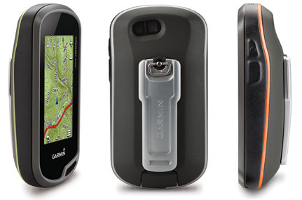
Updated form factor and customizable buttons
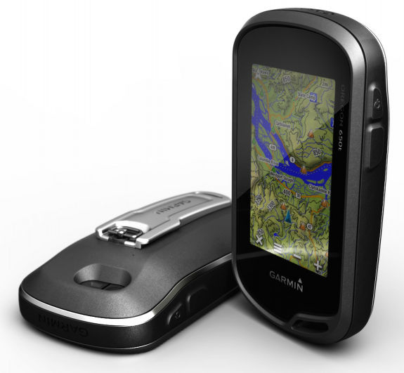
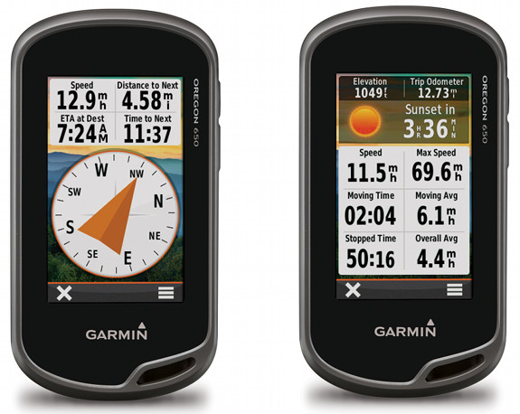
As you can see above, the Oregon series is getting a style refresh too. The new models are 1/10″ inch thinner and 1/10″ wider. It’s also slightly (0.6 ounces) heavier. One question I haven’t had answered yet is what that is on the lower right front corner of the unit.
The new models are getting “customizable buttons for one-touch image capture and waypoint marking.” Since it appears that there is only one new button, I’m assuming they have also added power button customization, a la the Montana series.
Multi-touch, capacitive touchscreen
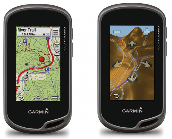
The new models will allow you to zoom, pan and rotate the map using multi-touch. Also noteworthy, this is Garmin’s first handheld to feature a ruggedized capacitive touchscreen (previous models were resistive). And according to the news release:
The reflective display technology boosts touchscreen brightness so much, maps and displays are as vivid in full bright sunlight as they are in shade…Oregon uses the sun’s light to produce a display that is twice as bright compared to the previous models and works with many types of gloves.
Note that while it says this is a reflective screen, that may be dumbed down, as I’ve been told it is in fact a transflective TFT screen.
Dual orientation display and nuvi mode
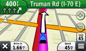
The 600 series can be viewed in portrait or landscape mode and it is also getting a nuvi mode for highway navigation, just like the Montana series.
Other interface changes
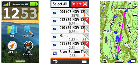
- One change is the addition of a couple more data fields to the recreational dashboard
- The trip computer now offers multiple pages of data fields, each customizable to 1 of 4 layouts: 2 large, 1 large and 4 small, 6 small or 8 small
- Advanced Waypoint Management – All data is displayed and editable on one screen; delete one or multiple waypoints at a time from the Waypoint Manager menu
- Shortcuts – Launch apps, switch Profiles, apply settings and start navigating with one touch
There is also a new “full track view,” although I haven’t quite figured out how this differs from what we have now:
Also new to the Oregon is the full track view—where users will see the entire elevation plot and quickly move their zoomed view to any place on the plot. Future plot uses users’ mapping data to show them what to expect ahead.
Battery options
The 650 and 650t models will come with a rechargeable NiMH battery pack rated at 16 hours that recharges when connected to external power. For longer trips you can swap this out for two AA’s in the field. I’ve gotten conflicting information on whether this will be standard with with 600/600t or just an add-on option. UPDATE: The rechargeable battery pack comes standard on the 650(t) and is an option with the 600(t) series.
Bluetooth and ANT+
UPDATE: After re-reading some correspondence with Garmin, I realized that I may not have gotten a clear answer on this, so I’m trying to verify if the Bluetooth is 4.0 or an earlier version. Stay tuned!
The new Oregon line includes Bluetooth 4.0 (AKA Bluetooth low energy), allowing you to “wirelessly transfer large files like photos, Garmin Adventures and Custom Maps between Oregon 600-series units (or with the BaseCamp Mobile app).” Unfortunately, the BaseCamp app remains iPhone only, although the folks at Garmin say they are “looking into” an Android version.
Also of note, wireless transfer speeds are now supposed to be up to 50% 50 times faster. The units are also ANT+ compatible for use with heart rate, cadence, chirp and tempe sensors.
8MP camera and a flash (and a flashlight)
The geotagging camera gets a big upgrade to 8MP and gets a flash as well! Also of note is a flashlight feature with strobe and multiple brightness levels.
Less data limits
UPDATE: Apparently there has never been a significant limit on BirdsEye imagery; we don’t know if there is any change re: custom maps yet though. BirdsEye imagery is now only limited by the amount of internal or microSD card memory, and apparently there is no limit on geocaches either:
The Oregon can hold an unlimited number of geocaches and supports GPX files from OpenCaching.com
Models, availability and pricing
The new models are slated to be available in the first quarter of 2013. The 650 series adds the rechargeable battery pack and 8MP camera. The 600t and 650t include 1:100,000 scale preloaded topos. The manufacturer’s suggested retail price is shown below. They list at $50-70 more than current models, but don’t expect to see steep discounts anytime soon.
| Model | MSRP | Features |
|---|---|---|
| Garmin Oregon 600 | $399.99 | Base model |
| Garmin Oregon 600t | $479.99 | 100K topos |
| Garmin Oregon 650 | $479.99 | 8MP camera |
| Garmin Oregon 650t | $549.99 | 8MP camera, 100K topos |
More info forthcoming
I’ll either update this post or publish a new one as more info (UPDATE: Done!…news release links, etc.) becomes available, so stay tuned. There’s also bound to be some interesting discussion in the comments section below; let us know if you have questions.



That’s a sexy looking device but I’m not sold on capacitive screens. It gets cold here in the great white north and taking your hands out of your gloves to manipulate the interface is not ideal.
I hear ya. They say it will work with many types of gloves. Looking forward to testing that; I’m betting fleece won’t work though.
Do they say anything about using touch screen in a rain? I would expect spurious reaction on water droplets.
They say this, a quote which I should have included: “Zoom in, pan out, and rotate using multi-touch in any conditions and even with most gloves.”
Thanks, good point 😉
I am not sure how good they are (& I have never tried them), but I have seen gloves with 2 (& even all) fingertips that are for touch screen phones. I will venture to guess the wold “work” on a;; touch screen devices …
I don’t think you’ll need anything like that… http://forums.groundspeak.com/GC/index.php?showtopic=306048&st=100&p=5193712&#entry5193712
I did cold weather testing of a pair of those touch screen gloves for a Canadian caching vendor and they were of no use at -9C (15F) for keeping your hands warm.
They are great for the phone, GPS, etc. but no good for keeping warm.
Hopefully they’ll work with a wider range of gloves!
It would be nice if this new Oregons would work with the upcomming Garmin Connect Mobile app, as the New Edges.
Heck yeah! Download a track at the trailhead! Surely we will see this.
“Also of note, wireless transfer speeds are now supposed to be up to 50% faster. ”
I believe that should read: “…50x faster.”
Thanks for catching that. I’ve fixed it.
My pleasure!
I have also started a new wiki for these units, but much of the information and screen images will have to wait until after I can acquire a 650t…
http://garminoregon6xx.wikispaces.com/
Nice!
No Wherigo??? This is a big No No for me!
Why? Wherigo has not been updated in years… Should be renamed Wheriwent.
You will not see Wherigo on any future Garmin handhelds for the foreseeable future.
Wherigos are better played on Smartphones now anyway. More power and flexibility. Garmin’s squabble with groundspeak nearly killed it anyway, glad that the community seems to be taking better care of the Wherigo concept (e.g. independently built Wherigo cartridge builders and players)
unlimited Geocaches!
That unrecognized symbol in the lower right corner might be a menu shortcut button. That is how I’ve seen it used in a few different apps.
Yes, it is undoubtably a menu icon.
Rich, I didn’t thing there was ever a practical limit on Birdseye, was there? I recall seeing something like a 50,000 tile limit for .jnx files. The current models (Oregon, Montana, etc) are limited to 4,000 tiles for traditional Garmin maps however (.img files). Have they changed this? According to a FAQ at Garmin support, the Nuvi series doesn’t have any such tile limit for .img files.
But the most limiting map spec on the Oregon is 100 “custom map” tiles (for .kmz files). They increased this to 500 tiles on the Montana. On Garmin’s forum in the past, the developers said that we would never see unlimited custom map tiles. Any indications about custom map limits on the new models?
My mistake, thanks for the correction. I haven’t heard a thing about custom map limits but maybe it’s something I can test when I get hold of one.
I hope the bluetooth allows updating geocaching or gpx files
via BaseCamp Mobile, I expect they will be 🙂
So, if the new Oregon’s are ANT+ compatible, then I take it that you can still share tracks and such with Dakotas, old Oregons, and the like?
I expect so, but I will ask.
I see they are putting the carabiner clip in the Oregon packaging, something I think they should have done in the beginning with the other touchscreen models.
They have been. Which ones are missing it?
The Dakota 20 for one.
Ah, I see. I wonder if they just didn’t want to include them in the models with a plastic rail, since it is so much harder to slide it on and off those models.
Yeah, I could see that, but following that reasoning, why would they put a rail on it to begin with?
Any word on when/if you’ll get a pre-production model to review for us?
I rarely get pre-production loaner/review units from Garmin, but I probably stand a better chance with a handheld, so I will ask. Otherwise it’s usually about when they are first released for sale.
That opening on the lower right of the front face sure looks like some kind of mini speaker port. If it is indeed a speaker of some type it sure would be a waste not to have voice navigation ability.
Interesting. I’m definitely going to ask about voice nav.
The apparent speaker port on the front may not be used for anything now (upon release) but Garmin could be planning to implement some kind of MP3 or audible navigation or video with sound in the future. It wouldn’t be unheard of especially the way Garmin works with things like that. They sometimes introduce new features after the product has been released a while and then refine them to be in the next model down the road at release. Maybe I hope too much.
Well, scratch that. From the two video’s on youtube it’s clearly a lanyard attachment opening. Oh well, I thought big.
Drats!
Capacitive screen? Sound like glove-unfriendly to me. Or we can still wear glove to use the new Oregon?
They say it “works with many types of gloves.”
The Garmin website says “gloved operation” which is stronger language than “many types of gloves”. Which one is more accurate?
Time will tell, huh?
Just get yourself some capacitive thread and sew a small square of stitching on the finger (of the glove) you want to use with it. Its not expensive, at least cheaper than buying capacitive gloves.
Nice tip!
@lilricky – Good point. Nice website BTW for the Florida Trail. I’ll try to remember to link to it in my roundup this weekend.
Not sure why the Oregons and the Montanas always have the fat magenta line when viewed in 3D during routing. It is taking so much space on the screen. The line on the Nuvis look good when compared with the one the Oregons or the Montanas.
Does it support “Where Am I? feature (find closest gas stations, grocery store, restaurant)” to make use of the POI that come with City Navigator?
If my Montana is any indication, no. But you can do Where To > All POIs, or even set up a shortcut for nearby POIs on the Montana, and I’m expecting you will be able to do that on the new Oregon line as well.
Unfortunately you are right. This is the answer I got from Garmin support:
“The Oregon and Montana devices will support re-routing routes,
however they will not support the where I am function.”
How does your suggestion work? City Navigator comes with A LOT of POIs, and most of them are of very poor quality. Valuable information might be hard to find in this plethora.
– How would I filter for example gas stations? Do they have a common attribute, like the search string “gas station”? Not convenient, but doable.
– How would I filter along the current routing? Being able to get an overview of the gas stations along the way is great – a gas station 30 miles ahead is an option, a gas station 30 miles abeam rather not.
Under ALL POIs, there is a fuel services category, but I don’t see a search near current route function.
anybody have an estiment of what month this is going to be avalibale for purchase because, i’m dying with out my gps. and i don’t want to buy an new one when garmin is coming out with this, i would like to buy it before more may.
GPS City is saying March 11.
A concern for me is whether a 24K topo I purchased for a 450 will work on a 650. I’d like to assume so, but I learned a *long* time ago the pitfalls of making even simple “no-brainer” assumptions. But then since I’m The Zombie of team ZombieDragonfly, no-brainer is my specialty! 😉
I’d also like to add my voice to the “What, no Whereigo?” camp. Sigh. I do not want to have to carry another device to play Whereigo cartridges. I don’t want to have to worry about my GPS-related games draining my cell phone battery, blah, blah, blah. 🙁
Which 24K map?
If you’re talking about the Garmin 24K series for North America then YES you will be able to load the maps onto a new unit or any unit for that matter. The Garmin 24K Topo series is not locked and does not lock to a specific unit. You may want to check the license terms and agreements as far as keeping with legal integrity but there is no technical reason it would be limited.
Not to be confused with the older 24K National Park series maps, which were locked.
I hope this one will be better than than the new etrex series. I bought an etrex 20, that I sold almost immeiately after the purchase. It so awfully slow that it was unusable for me.
It is better to wait until the first reviews and see if there are any serious shortomings (like with etrex).
This video confirms the addition of a night mode to the new Oregon line. Bout’ freakin time.
http://www.youtube.com/watch?v=3bz0Hgnx6go
Do they have any information on the tiles that it will be limiting for .img files?
Not yet.
There is some anecdotal support that these units will be Bluetooth 4 since the Basecamp mobile app requires an iPhone 4S or greater which is where they introduced the BT4 feature.
ciao !,sempre dall’italia il gps oregon 600 stà per essere messo in vendita solo adesso
ed io sono interessato all’acquisto .voi lo avete già provato funziona bene oppure ha qualche problema. è più consigliabile etrek 30.a voi una risposta grazie
I have not tried it and don’t expect to have one in hand until mid-March.
I am a novice to the GPS world. I would like to thank you for educating me through your web pages. Your instruction information has really been helpful. Also, thank you for steering me towards the GPS City. When I make my purchase I will initiate it through your link to GPS City. I have also been to their website and feel the purchase through them would benefit me by their instructions and support. I volunteer for a non-profit that does mammal surveys with motion/heat activated cameras. They give us the coordinates for the camera placements and we install, monitor, move them monthly and then retrieve at the end of each session. I think I am now ready to take the plunge and purchase a GPS. I will use this for hiking, my volunteer work and in my wildflower hikes. From reading your work I think I am ready for either the Oregon 450 or the 62s. In reading between the lines, I believe you might prefer the 62s. Then I read your report on the 62sc and I think it would be neat to have the camera for wildflowers and be able to go back to that same spot at a later time. It is going to cost me $50 more for the camera. Do I have a camera? Yes, but it might be nice not to have to carry both. In your opinion is the camera on the GPS worth the $50? Do your have any other thoughts on the Oregon 450, 62s or 62sc? I probably read too much of your material as I read the Oregon 650t, Glonass unit, that will be coming out soon. Do I wait? Thank you so much for all you do.
Jerry
Glad you are finding it helpful! The Oregon 600 series might be worth waiting for. I prefer the 62s over the Oregon 450. The 62sc camera isn’t great, but it is convenient for grabbing a geotagged photo.
Thank you so much for your response. I guess my next question is when might the Oregon 600 series be available? I believe I read that in the information you had initially received from them it would be iin the first quarter. That first quarter will end this week. Have you received any other updates?
Thank you.
Jerry
GPS City usually offers the best guide on this, but sometimes they reach the estimated day and bump it back a bit more. Right now they are saying April 5… http://www.gpscity.com/garmin-oregon-600.html
Other sources suggest that initial quantities may be limited.
Remember I am very new in the GPS field so this question may sound ridiculous. The 62s appears to have an external antenna similar to the 60 series. The proposed Oregon 650 does not have that antenna but will have the Glonass. I am guessing you have tested some other models with Glonass. Will that 650 have the same ability to locate satellites because of the Glonass? Thanks.
I’m not entirely sure what you’re asking. The Oregon 6×0 series will be able to use GPS and/or GLONASS satellites, which should mean beter reception, especially in northerly latitudes and urban or natural canyons. Whether the antenna will be as good as the 62s, I can’t say. But I will add that handheld GPS antenna type doesn’t seem to make much difference these days.
Hope this helps.
I want to pre-order the Oregon 650 at GPS City. I also want you to receive some credit for this. If I go to GPS City’s web site via one of your links it will not take me directly to the Oregon 650. As far as I have been able to determine, the only way I can open the Oregon 650 page with them is to use their search box. The page then will say they expect to ship during the first week of May. If I use any of your links and then use their search box to open the 650 page will it still provide credit for you?
Thanks Gerald, I appreciate it., Any of the GPS City links on my site should work, but try this: http://www.gpscity.com/garmin-oregon-650.html?afcode=57RJ621DK
Just to confirm with you, I placed the order on April 21. I followed your link to their site. I hope it works for your credit. The unit is scheduled to be shipped May 5-6. I am sure I will have questions for you after I receive mine. Thank you for all your help.
Thanks Gerald!
Any word on the voice or volume level for the turn by turn directions? Even with its special cradle the Montana was miserably quiet. Does this do turn by turn spoken directions (with citynav maps)? If so, how is the volume compared with the Montana? Will it utilize the car speakers via bluetooth??
No, but I’d be surprised if it did more than beep. And the chances of it outputting directions by Bluetooth are even less — no nuvis do that.
The GoOutdoors review on YouTube confirms that vehicle navigation is limited to beeps to indicate a new direction.
“Unlimited Geocaching: The Oregon can hold an unlimited number of geocaches and supports GPX files from OpenCaching.com for downloading geocaches and details straight to the unit.” – Garmin
http://garmin.blogs.com/pr/2013/01/incredible-high-res-multi-touch-display-gpsglonass-and-8-mp-camera-the-new-garmin-oregon-series-pack.html
Will the Oregon 600 series be able to use Groundspeak’s geocaching.com cache data? In my home area OpenCaching.com isn’t too popular being that the closest cache is about 100 miles away and there are only 31 caches listed in the whole state. As for Groundspeak’s geocaching.com there are hundreds of caches listed here in Hawaii. The new 600’s are looking sweet even without a real review yet. Thanks and Aloha from Maui.
More specifically, can they use the GPX files from the Groundspeak geocaching.com site being that Garmin and Groundspeak had past issues? Thanks again. Aloha
You can use GSAK to do it.
Hopefully GSAK will come out with an update for the new format too. From what I understand the 6xx series will accept (virtually) unlimited caches in the gpx format but is MUCH faster when using Garmin’s new filesystem (compressed gpx with some additional support files).
Pretty sure they already have.
Well, that’s mighty convenient!
I recently got an Oregon 600 for my wife. We just Geocached with it for the first time this weekend and it worked flawlessly…very accurate…except the odometer which is way off.
We haven’t had much chance to try all the features, but the initial comment I would make is about the battery indicator. I bought the NiMH battery pack and charger and when plugged in, the battery indicator bars flash in sequence, but never show the level of charge…only that it is charging. There doesn’t seem to be any way of knowing when to disconnect. Once disconnected, the indicator shows four bars (full charge…or is it???). A percentage indicator is really needed in my opinion. It’s possible that I just haven’t reached actual full charge yet and that if I did, it would indicate that, but I had it charging for quite a while.
Oh, one other small thing…the time display is just weird.
I agree that they need a percentage indicator. Yes, the time display is weird; it follows the latest Android styling.
i am very torn between the 62s and the oregon 600. i use it a lot for marking fishing holes on various lakes as well as hiking ilike theidea of touchscreen but how does it do when wet? any help would be appreciated fellas
thanks
I had my 650 out in light rain a few days ago and had no problem with the touch screen whatsoever.
Just smeared a bunch of water on the 650t and tested it. No problem at all.
I encountered an annoying little problem the other day with my 650.
The symptom was that it would occasionally crash and have to load all maps/geocaches/waypoints from scratch. More often I was able to turn it off just fine but when I turned it back on it would, once again, have to load all of those which can take upwards of 5 mins.
The cause, as near as I can tell, had to do with changing the time zone from automatic to eastern time. We were on a cruise ship and automatic time zone, at sea, evidently does not account for daylight savings time so I switched it to eastern time so that I would always be on ships time. So long as I had that set I was plagued with problems. Once I took that off and left it set to automatic time zone I had no further issues at all.
s i have seen some reviews of these from you and was wondering which one you recommended? Is the touch screen good like an iphone? Seems easier to find waypoints with it etc…what do ya think?
I personally have tried the Oregon 450, Delorme PN-60, Magellan GC, Geomate Jr., iPhone 4s, and the Montana 650. With all of those I had a wish list of everything I wanted in an ideal GPS – unlimited geocaches, multi-touch screen, reasonable size (Montana is really huge when out on the trail), bluetooth connection to phone, trun by turn directions. The Oregon 650 hits on every one of them. It is, pretty much, my dream GPS. So far it has proven to be extremely accurate, it’s got a very respectable battery life, and unlimited geocaches absolutely takes the cake for me.
Unless cost is your objection, the Oregon 600 series is the only GPS I would recommend to someone right now!!
Thanks! That is the onbe I will pursure…thansk fellas!
To clarify – the turn (not trun) by turn directions are not standard out of the box, and do not have voice guidance (yet?) but alert beeps. To get those you either have to buy Garmin’s City navigator maps (which are VERY good), or use one of the open source projects such as OpenStreetMap (http://garmin.openstreetmap.nl/). I am currently using the open source maps and while they are not nearly as good as Garmin’s, they are in fact quite nice.
Also their BlueTooth integration currently only interfaces with BaseCamp on the iPhone though apparently they are working on an Android version. My hope is that they use this in the future to give actual voice navigation over your cars stereo like I can do with my iPhone but I don’t know whether that will ever come to pass.
The new Garmin 24K topos do turn-by-turn too.
Bought a Garmin 600 after seeing what my friend’s Garmin 400 could do. I thought I was getting as many if not ore features. I was disappointed to find out it does not do a Where I Go.