
Hands on review of the Garmin GPSMAP 741xs
The Garmin GPSMAP 741xs is an all new marine chartplotter from Garmin. The GPSMAP 741xs has a 7″ diagonal color screen and an all new look. In the past, Garmin has used silver bars at the top and bottom of the case. These have been removed and replaced with an all black look that is similar to the ultra high end 8000 series.
A major upgrade over previous generation is wireless capability (wifi and bluetooth) and the sounder module was upgraded to include CHIRP technology. The GPSMAP 741xs includes pre-loaded charts for the United States Coastal Region and also has dual MicroSD card slots for additional charts. The dual MicroSD card slots are also used for transferring waypoints, routes and tracks.
Related models
- Drop down to the 500 series for smaller screen that is not touch
- Drop down to the 721xs for wordwide basemap only
- Drop down to the 741 to remove the sounder module
- Drop down to the Echomap 70s and you lose: NMEA 2000, CHIRP Sounder (it has Echo HD-ID sounder), and 3d Chart views
- Move up to the 4000 or 6000 series for larger screens that are not touch, and a very different feature set
- Move up to the 5000, 7000, or 8000 series for larger touch screens and a very different feature set
Display
The display is a 7″ diagonal, with 800×480 pixel resolution. The display was extremely bright and easy to read in direct sunlight and also while shaded. The display is also very bright and easy to read when viewed straight on with polarized sunglasses. On a few different angles, the screen can opaque out with polarized sunglasses.
The resolution is good for the screen size and all the chart items are clear to read. Garmin has added a feature that automatically adjusts screen brightness to the ambient light. The automatic adjustment seemed to have a very broad range. Even late at night, the display went all the way down to a very comfortable brightness level.
Interface
If you have used any of the more recent devices from the higher end of Garmin’s Marine line, the interface and menu structure will be very familiar. The only hardware button is the power button. All other functions are used on the touch screen.
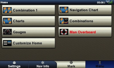
Garmin GPSMAP 741xs main menu
Pressing the Home button takes you to a main menu where you can choose the major functions. I only found one part of this screen confusing. Occasionally I would look for Nav Info or Settings on the main part of the Home Screen, and those were instead spread across the bottom. From the home screen, you can choose Chart, Sonar or a combination. Other options may show up on the home screen if you have accessories attached such as XM weather, an interface to engine diagnostics or other sensors. From the home screen you can drill down to the specific function that you require. After you choose Chart for example, then you can choose a conventional top down chart or a 3D chart view.
The Home menu can be customized by adding some of your favorite screens and reorganizing the order. This will help alleviate drilling down through the menus to find your favorite screen. You can not delete any of the default choices from the menu that were included by Garmin. In the above screen shot, I added “Combination 1” to the default list. The combination screens can be renamed to make them more logical.
The touch screen makes creating waypoints and routes a very simple affair. Simply touch a point on the chart and you can create a waypoint at that position. Once you use an on screen numeric keypad for manually entering lat/lon’s and the on screen QWERTY keyboard to name waypoints and routes, you’ll wonder how you ever got by without a touch screen in the past. While out on the water during testing, I received a mayday call from a sailboat that was taking on water. I was able to quickly enter the lat/lon and determine the exact location and my distance to that location.
As easy as the touch screen makes programming in calm water, it can make programming that much of a challenge to use while underway in a heavy sea. With rubber hardware buttons you can rest your hand on the button before you commit to a button press. With a touch screen, you don’t have that luxury. Trying to enter waypoints while getting bounced around in heavy seas proved to be complicated and fraught with accidental button presses on the screen. Please consider the type of seas that you frequently or even occasionally travel before committing to a touch screen device.
Garmin GPSMAP 741xs full screen chart
On the Chart Screens there was always a row of buttons across the bottom of the screen. The display is “landscape” orientation and those buttons take away quite a bit of real estate from the bottom of the chart. Unfortunately these buttons can not be configured to run down the right side or be configured to disappear. Which makes for a somewhat awkward aspect ratio to the full screen chart.
Wireless Connectivity
The newly added feature that excited me the most about the GPSMAP 741xs was the wireless connectivity. I already had Garmin BlueChart Mobile installed on both my iPhone and iPad. It was very simple to use the GPSMAP 741xs to create a wifi network and connect my iOS devices to that network. Please be advised, while the iOS device is connected to the boat’s wifi you are not able to connect the iOS device to the internet via wifi at the same time, but you can connect your iOS device to Cellular internet.
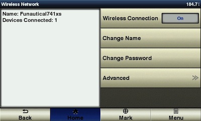
Garmin GPSMAP 741xs wireless setup screenshot
Garmin BlueChart Mobile allows you to easily create waypoints and routes on your iOS device. After I had a few waypoints and routes created, it was extremely simple to transfer the waypoints and routes from iOS to the GPSMAP 741xs. It was also very simple to transfer any waypoints, routes, and tracks back from the GPSMAP 741xs to the iOS device.
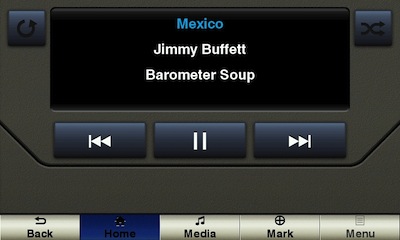
Garmin GPSMAP 741xs music control via Bluetooth
The GPSMAP 741xs also allows Bluetooth Connection to audio devices such as smart phones and digital music players. Currently the only profile that is supported is AVRCP. That means you can use the GPSMAP 741xs to see what song is currently playing. You can also pause, play and advance to the next track. This remote control is not limited to controlling iTunes only. Remote control seems to work with any music playing app, including iTunes Radio (streaming), Songza and others.
Wired Connectivity
The industry standard NMEA 2000 connection will allow the GPSMAP 741xs to interface with a variety of other devices aboard a boat. This includes both Garmin and non-Garmin devices. Engine diagnostics, weather instruments, sail instruments, VHF/DSC, and AIS is a small list of available interfaces. There are many more NMEA 2000 devices yet to be released or even yet to be envisioned! The industry standard NMEA 2000 interface will make it simple for boaters to connect up the GPSMAP 741xs to obtain the full functionality of DSC.
All mariners are advised to connect their GPS to their DSC capable VHF radio and register their MMSI. If a DSC distress call is made with no MMSI transmitted, no GPS Lat/Lon, and communication can not be established with the distressed vessel, the USCG will classify the call as an uncorrelated distress call and suspend the SAR case until more information can be collected.
The industry has developed standard connectors among all manufacturers that build NMEA 2000 certified devices. This means that you can connect the GPSMAP 741xs with other certified NMEA 2000 devices without splicing wires or doing any soldering. Hooking the GPS 741xs into an existing NMEA 2000 network is about as simple as plugging in a USB mouse into a computer. Creating a NMEA 2000 network is slightly more complicated, but should not be a problem for most amateur installers.
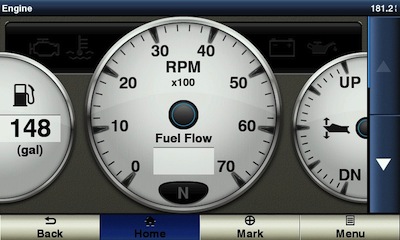
Fuel flow and engine diagnostics shown via NMEA 2000 connection
After connecting The GPSMAP 741xs into my existing NMEA 2000 network, it immediately identified my two Garmin GMI 10’s and also my Volvo EVC-D engines. All the information provided by the Volvo EVC-D bus was flowing into the GPSMAP 741xs, including fuel flow and all engine diagnostics. The GPSMAP 741xs was also giving the Volvo EVC-D bus certain GPS information including speed and distance traveled. This permitted both the GPSMAP 741xs and the Volvo Display to calculate fuel economy expressed in MPG or NMPG. (note: the internal GPS antenna in the GPSMAP 741xs was the only GPS sensor on the NMEA 2000 network during the testing)

Wind speed and direction from NMEA 2000
While NMEA 2000 is industry standard, apparently there are few manufacturers that have some different ideas how things should work. I happen to have a NMEA 2000 Bennett trim tab level indicator kit on the network (the NMEA 2000 interface was apparently manufactured for Bennett by Lowrance). The GPSMAP 741xs would not indicate the trim tab position (neither will my Garmin GMI 10‘s). Apparently the only way to get the trim tab position to show up on the Garmin Displays is to use the Garmin GBT-10.
The back of the GPSMAP 741xs also has a RJ-45 ethernet port. This port is only used to connect Garmin Radar. This port can not be used with any other devices on the Garmin Marine Network. This is a real shame since even the ultra high end 8000 series do not include wifi. The GPSMAP 741xs would make a really nice edition to a flybridge or cockpit of a larger boat that has a Garmin Marine Network installation, while also adding wifi capability to that network. I did not have a RADAR to test with the 741xs, so I was not able to test features such as MARPA.
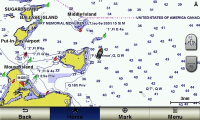
Nautical Charts Display
The GPSMAP 741xs includes preloaded charts of the U.S. Coastal waters and the Bahamas in internal memory. The charts in internal memory allow a Perspective 3D view that includes the same bottom soundings and land masses that are on the normal 2D chart view. Additional charts can be purchased and loaded using the dual MicroSD card slots on the front side.
The pre-loaded charts are very easy to read and have great detail of the entire U.S. Coastal area, including the Great Lakes. Keep in mind these charts are U.S. & Bahamas waters only. They do not include charts of our nearest neighbors such as Canada and Mexico.
The spot soundings are easy to read and very clear. The shoreline detail and land masses are clearly marked and labeled. All Navaids are simple to identify. Especially with the touch screen, you can tap near a navaid and then bring up additional details about that aid.
3d Mariners View requires g2 Vision Bluechart card
If you load an optional MicroSD card with Garmin’s Bluechart G2 Vision charts, then the 3D MarinersView and 3D Fishview become available in the menus. The Marinersview and Fishview attempt to draw a 3d representation of the bottom contours similar to a bathymetric chart and they use some different colors to represent danger areas on the chart. You can adjust the safety depth as it applies to your own vessel. The colors displayed on the chart will also adjust so that safe water is easily identifiable.
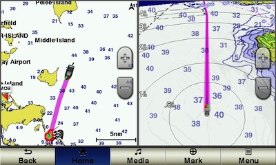
Garmin GPSMAP 741xs split chart view and perspective 3d
The charts can also be split with other chart views. The screen shot above shows a conventional top down (North up) chart and also a Perspective 3d chart with a navigation route activated. The last screen shot below shows a large scale navigational chart next to the RADAR screen. I did not have a RADAR unit to test the RADAR functions, the screen shot is from the demo mode. I also included a few data fields on the right side of the screen.
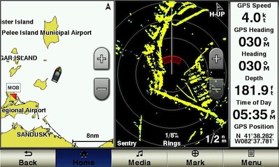
Split view showing chart, radar and data fields
Navigation
Once a recreational boater gets their GPS programed with waypoints and routes, many boaters are comfortable with the highway screen as a graphical means to following those waypoints and routes. Garmin seems to have dropped that highway screen nomenclature from the menu structure, even though that same GUI concept is alive and well. The screen that is the most similar to the highway screen is now under the Chart menu and it is called Perspective 3D. This screen now includes chart data.
Waypoints and Routes are easily found using the Nav Info menu item from the Home Screen. The Waypoints menu shows a list of all waypoints starting with the nearest, ending with the furthest. In addition to Waypoints, Routes and Tracks, the Search by Name menu also includes Offshore Services. This is POI data that allows you to search for various service that you may require on the water, services such as Fuel, Repairs, Grocery, Restrooms, Boat Ramps, Marinas, etc. The data is pulled from the pre-loaded Bluecharts or from data that is contained on a optional chart card.
Keep in mind that if you navigate to any of the POI’s or waypoints, that the GPSMAP 741xs will take you on a straight line to that point. That straight line may take you over dangerous water or even over land. If you choose a point from the POI database, the GPSMAP 741xs will show you the chart screen with the position of the POI that you selected. It will then ask you to enter additional Turns to get to that point. It’s very simple to add waypoints to plot out a safe route through safe water using the pre-loaded charts. However, this is not something that the GPSMAP 741xs calculates automatically out of the box.
If you add a Garmin Bluechart G2 Vision card, the GPSMAP 741xs will perform auto guidance. This allows you to choose a waypoint or POI, and the GPSMAP 741xs will calculate a safe path through deep water to that point. If you use this feature, I highly recommend that you exercise extreme caution. I have seen auto guidance create questionable routes, that I would not follow. Keep in mind that charts are not always accurate, especially if they are not up to date. Careful consideration should be given to any route calculated by auto guidance.
Sounder
Be advised that Garmin has recently had a change to their cabling. The new transducers come with an 8 pin wire harness, which fits perfectly into the GPSMAP 741xs. Many older transducers use a 6 pin wire harness that will not plug into the GPSMAP 741xs.
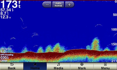
Sounder screenshot
All my testing was completed with my existing thru hull Airmar B60 transducer. Unfortunately I was not able to test any of the new CHIRP capabilities since I was lacking a CHIRP transducer.
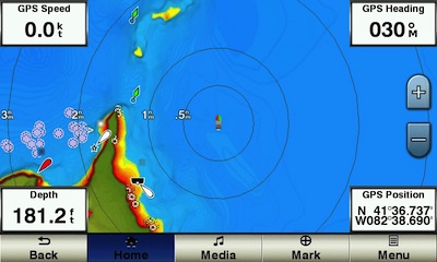
The sounder was able to see the fish and also determine the approximate bottom composition. The sounder was able to maintain bottom lock all the way up to the maximum speed of my boat at 52mph. The sounder has many different options for zooming, gain, and varying frequencies. That should give any angler a great advantage over the fish. One new feature of the 741xs is Sonar Recording to the SD card. The sounder screen is also able to be customized to show other information including a compass tape with CDI. So you can monitor the fishfinder while navigating to a Waypoint. You can also split the screen to show the sounder along with a top down chart or the Perspective 3d chart.
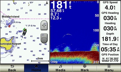
Sounder shown in split chart mode
Mounting
The GPSMAP 741xs offers a few different options for mounting to your boat. Included is a mounting bracket that can be affixed just about anywhere. The mounting bracket allows for articulation up and down only, there is no left to right articulation.
The GPSMAP 741xs has a trim ring that pops off the front and exposes mounting holes for surface mounting. The GPSMAP 741xs is attached from the front which is much more simple than many of Garmin’s previous surface mounting methods. One small complaint is the cutting template has some gentle curves to match the curves of the back of the GPSMAP 741xs. It would be so much more simple to cut the hole if the template had straight lines on all four sides.
An optional flush mount kit is also available from Garmin. This will result in the front edge of the GPSMAP 741xs being completely flush with the surface that it is mounted into. It’s an extremely finished look that I am sure many OEM boat builders will use with this model.
Garmin GPSMAP 741xs pros
- Wifi connection to BlueChart Mobile
- Ease of use, simple menu navigation
- Very bright screen
- Pre-loaded U.S. coastal & Bahamas charts
- Built-in sounder module
- NMEA 0183 & NMEA 2000 connectivity
- Touch screen
Garmin GPSMAP 741xs cons
- Screen goes black at extreme angles with polarized sunglasses
- Incompatible out of the box with older transducers
- Not compatible with Garmin Marine Network
- Touch screen
Garmin GPSMAP 741xs conclusion and recommendation
The latest from Garmin excels in many categories and only has a few drawbacks. I can recommend this to any recreational boater or angler.
More Garmin GPSMAP 741xs reviews
- Consumer-authored Garmin GPSMAP 741xs reviews have been posted at WestMarine
We’ll be posting more hands on GPS reviews as they appear, but in the meantime, here are some…
Other Garmin GPSMAP 741xs resources
- The Garmin GPSMAP 741xs owners manual
- Garmin GPSMAP 741xs FAQs
- A Garmin Fishfinder/GPS combos comparison tool
- The official Garmin GPSMAP 741xs
web page
- A video view of the 741xs:
Compare prices on the GPSMAP 741xs at these merchants:
- Check the current Garmin GPSMAP 741xs w/ 7in WVGA Touchscreen Display
price at Amazon
- Get the Garmin GPSMAP 741xs from GPS City
- Buy the Garmin GPSMAP 741xs

I bought one of these units, it was recommended to me by a “expert” in a chandlery shop. He said it far exceeded the Lowrance version. the Garmin unit is the biggest most expensive piece of rubbish I have ever bought. I hate it!!
What don’t you like about it?
I purchased a garmin radar HD and the 741xs and wow, what navigation ease that is… Dense fog at the north of Vancouver island, allowed us to navigate on a split map/radar/data screen. As any software product, there are some bugs and minor user interface issues but overall it is a very intuitive use.
All nmea 2000 and 183 devices are flawlessly receiving and sending information to and from the 741.
I would love to have a repeater down below at the chart table. Any suggestions? the Ethernet port perhaps?
Regards
Roel
.
You can connect a ipad or android tablet, control and see exactly what is on the 741sx display.
It used the Bluetooth or wifi connection
how do I get my tracks to another garmin that I am buying for my new boat