 When I was on the road doing GPS mapping demos, pitching my book, it became clear what things confused people over and over again. So today we’re going to take a look at one of those and inaugurate a new category — FAQs (I’m going to dig through the archives and add at least one other post to the category).
The issue today is routes vs. tracks. What is the difference? A route has the following characteristics:
- It is used in the field to guide you from waypoint to waypoint.
- It uses straight-line, as the crow flies, navigation. For highway navigation, the term "route" has a slightly different meaning.
- It is about where you are going.
A track, on the other hand, has the following defining characteristics:
- Tracks are about where you have been.
- They are a record, created by your GPS, which is constantly recording your location. Many people like to use the analogy of an electronic "bread crumb trail," ala Hansel and Gretel.
- They more accurately reflect the shape of the trail or road you have taken than the straight-line segments representing a route.
- They can be downloaded to your computer to create a record of your trip.
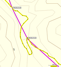
We can see the route in the image above, represented in pink, showing straight-line segments between waypoints. The track, shown in yellow, more closely resembles the shape of the trail.
Now many new GPS users don’t like this. They want their receiver to guide them at every turn of the trail. But think about it–you don’t need your GPS to tell you there is a bend ahead in trail. You just need it to guide you to critical waypoints–trail junctions, campsites, etc.
There is much more to say about both routes and tracks, but I hope that this will give you a basic understanding of the difference.

Thanks very much…. this is the only place I could find this information on the net. My software, topo USA 5.0, also has trails. What’s the difference between and track and trail or a route and trail?
Paul,
On most mapping programs, creating a route between waypoints on a trail will give you the straight-line, as the crow flies segments mentioned above. On DeLorme Topo USA, you can actually route along the trail, giving you an accurate estimate of the distance you will travel. Which doesn’t help much in anything other than trip planning or creating a map. However, DeLorme’s GPS PN-20 can route along trails in the field. It comes bundled with Topo USA 6.0.
Love your photos BTW. Spent some time in the Palouse when my wife was at WSU.
With a Garmin oregon 300 the distance from waypoint to waypoint is as “a crow flies in a straight line”. This gives a very deceptive distance. The “as a crow flies” will be 4 miles. In reality, the ACTUAL distance traveled could be 7 miles. When planning a 7 day backpacking trip on the CDT it is very important to know ACTUAL distance from start to finish! This will give the person a REALISTIC distance, thus they know how fast/slow they will have to travel to get from start to finish and a very good estimation of how much TIME it will take. The Delorme pn-40 will allow you to do this. A huge difference when planning an extended backpacking trip that covers 20-100 miles.
A track is necessary, vs. a route, when navigating in Bush Alaska. A straight line between waypoints could get you killed by dropping you into open water, in the winter or run aground in the summer.
Thank you for explaining all this. It does not answer my problem though. I am not walking with GPS, i stick to asfalt so i do want my route to correspond with my track. If i would want my navigator to tell me where to go when i am on my bike i don’t want to go as the crow flies. I have outlayed a track in my computer, but i don’t seem to be able to get it into my navigator unless it is a route.
But this site is for (off road) hiking? So you use it differently i think. I will continue to search for an answer on the web. Thank you so far.
What kind of navigator do you have?