Yesterday I posted about being able to convert National Geographic TOPO (.tpo) track files to .gpx using GPSBabel. This is something that will excite quite a few people, as it overcomes what (IMHO) is TOPO’s biggest disadvantage. Let’s take a look at the whys and hows.
When I first discovered GPS and mapping software, I went wild mapping trails in our area. I mountain bike with my wife every weekend, but the area we ride is private land, and there are no good trail maps. My first software purchase was National Geographic TOPO! Not only did I record tracks of rides, I started adding logging roads that show on aerial photos, trails that only showed up on 1:100,000 scale maps, etc.
 In an effort to build a complete map of the area,
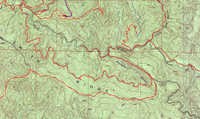
I kept adding data to the same map file, but I ended up with a mess; a relatively clean section of map is shown at left. To make matters worse, when I used the same trail again to access a new area, TOPO layered GPS tracks on top of one another, which caused all sorts of problems. If the track was fairly accurate, you couldn’t even tell this unless you deleted the top layer.
As my mapping got more sophisticated, I wanted to extract tracks for clean printed maps and to load to my GPS. But extracting tracks in TOPO was a pain until the recent update of GPSBabel. But once you extract the tracks, then what do you do?
I chose to extract them in the .gpx file format, since it’s become something of a universal standard. The TOPO file I extracted tracks from contained over a hundred track segments, but when I opened the .gpx file, there was only one track.
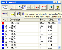
 I then turned to OziExplorer and imported the .gpx file. (BTW, I believe you can do everything I’m describing here in Ozi’s trial versions.) Using the Track Control dialog, I chose the button
that says "Use mouse to draw a box around a track point. All track points in the same track section are made active." (See image at right). Then, under "More options for active track points," I selected "Save active track points to a file." Ozi forces you to save this in their .plt format, but Ozi can also convert it back to .gpx.

<Tangent>Just to check it out, I tried converting the .tpo file to Ozi’s .plt format using GPSBabel. It put over a thousand files on my desktop, so if you’ve got a bunch of data, you might want to stick to .gpx files, or at least create a separate folder.</Tangent>
The end result? Beautiful clean tracks (example at left) ready for use in your GPS or favorite mapping software!
Brief commercial message: There are separate chapters in my book, GPS Mapping – Make Your Own Maps, on National Geographic TOPO!, OziExplorer and many other mapping programs. You can check out the table of contents here.
Technorati tags: GPS

I am trying to convert TPO files from MapXchange (http://maps.nationalgeographic.com/topo/search.cfm) using GPSBabel, but it gives the message that it can only convert tracks, not routes or waypoints. So I am out of luck.
Zack,
It seems to work for me with some files, and not others, and on some it mangles the waypoint names. There is a GPSBabel forum at https://lists.sourceforge.net/lists/listinfo/gpsbabel-misc. Maybe someone there could help.