Sunday, March 18, 2012

MapQuest To Continue Deal with TomTom

2mapquest

TomTom, the Dutch navigation and mapping company, has announced that it has expanded its deal with the GPS navigational software company MapQuest. The original deal, which was first struck in 2012 and has been extended since then, allows MapQuest to use TomTom’s extensive map database for its digital platforms. But this year, some additional things were added.

According to the press release, MapQuest, a subsidiary of AOL, has also brokered access to TomTom’s traffic information, leading speculation that MapQuest will soon be offering better traffic options. Currently, MapQuest already offers some traffic information for drivers, although it is not always accurate. However, this partnership may mean some big things for MapQuest. read more

Indoor Location Technology on the Rise

sirfusion_indoor_location_android

CSR has announced that they have perfected their indoor location technology and will be offering it to Android developers in the form of an SDK in the first quarter of 2015. This technology uses a combination of real-time WiFi signals, satellite positioning information, pedestrian dead reckoning and the company’s cloud-based CSR Positioning center to calculate accurate indoor location for consumers inside of complex building structures. read more

Garmin Introduces Hunt View Maps

hunting

When you are hunting, there are a lot of things that you have to be aware of to ensure your hunt is legal and now, with Garmin‘s new Hunt View Maps, you’ll have one less thing to worry about. This series of preloaded microSD cards contain essential map data showing public vs private land so you don’t ever have to question where you are. The maps also contain satellite imagery, 24K TOPO mapping and routable roads. The maps are currently only available for Colorado, Idaho, Montana, Wyoming and Utah.

The maps are $80 each and are available for purchase on Garmin’s website now. Each map comes with information for the entire state and provides borders and boundaries for public and private land as well as rural roads for better navigation. The card also supports turn-by-turn navigation for rural roads to help hunters navigate in unfamiliar country. read more

Strava Wants to Turn Your Smartwatch into A GPS Watch

stravaA GPS running app has been updated to allow a sleek and sexy smartwatch to replace your clunky sport GPS watch or your plastic oddly-colored fitness tracker. The Strava Running and Cycling GPS app has been around for a while, and recently announced compatibility with android wear smartwatches in an effort to get in on the new fad and take over for your GPS. The app requires using your phone’s GPS which, as we all know, isn’t nearly as reliable for positioning as a dedicated GPS device. However, unlike a dedicated GPS device the app is free (with a premium option, of course). read more

Garmin Upgrade for GTN Provides Features, Better GPS

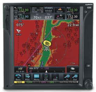
GTNGarmin has announced an upgrade will provide additional features to their GTN touchscreen avionics. New features include Connext cockpit connectivity, which allows for wireless flight plan transfer between the TGN 750/650 series navigators and Garmin Pilot (which also recently received an upgrade). Connext will also provide better GPS position data and the option to display weather, traffic and altitude information. This upgrade will include database syncing capabilities, FastFind to make searches easier and more streamlined,  airspace altitude overlay, WireAware to help avoid wires and more. read more

Google Maps Working to Dominate Mapping Industry

Google UpdateGoogle has been in the process of taking over the internet and the mapping business for several years now. A recent presentation by Ed Parsons, Geospatial Technologist at Google Research in London gave some pretty interesting statistics about the prevalence of Google Maps that might make some GPS companies a little nervous.

According to this spreadsheet, Google map tiles are available for 209 out of 218 countries. For those 9 countries not covered by Google maps, only three do not offer driving directions (Cyprus, Kiribati and North Korea). And, while many dedicated GPS devices have similar map coverage, Google Maps doesn’t require a separate unit and is completely free. And, as of July 17, Google Maps on Android updated to version 8.2 which allows for hands-free voice commands (although they seem a little limited) that many dedicated GPS units enjoy as well as elevation measurements for mapping bike routes. Google also now allows for maps to be saved for offline use, although it does not map routes without a connection. read more

Microsoft Announces Retirement of MapPoint Software

MapPoint

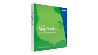
Microsoft has announced that they will be retiring their MapPoint Software, a Windows-only mapping and navigation software developed in 1999. This once-popular mapping program will likely go out with little fanfare, as Google Maps and Bing Maps have pretty much taken over the market of online mapping programs. AutoRoute and Streets & Trips will also be discontinued at the end of this year. According to Microsoft’s farewell page, they will continue online support of these programs until at least July 2015. read more

Endomondo App Syncs with Pebble Watches

ENDOMONDO LOGO

Endomondo, the popular social fitness network, has introduced a new smartphone app that syncs with Pebble and helps users meet their fitness goals. This free app from Endomondo allows users to start, pause or stop a workout while exercising and can display up to three configurable data metrics, such as distance traveled, heart rate and workout duration – making it one of the most advanced fitness tracking apps for Pebble.  Additionally, the app vibrates Pebble smartwatches for each mile or kilometer completed, and will briefly display a performance summary. read more

Garmin Pilot Goes Global With New Update

Garmin Pilot

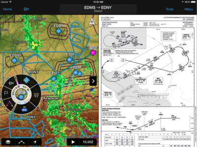
Garmin today announced worldwide coverage of the Garmin Pilot application for iPad and iPhone. The application, available from iTunes, is an excellent app for aviation, providing flight planning capabilities, comprehensive weather information and navigational aids. However, prior to the 6.2 update, it was only available in the U.S.. Garmin has clearly stepped up to the plate and is attempting to make a name for themselves on the international aviation market with this update.

New features include FliteCharts, SafeTaxi airport diagrams, FastFind, Smart Airspace and fully customizable 3D maps of ground, water, terrain and other features necessary (and convenient) for pilots flying in international and overseas airspace. read more

Wherigo Combines GPS with Computer Games

Computer games have become more and more popular over the years, and according to the ESRB, roughly 67% of all households play video games. In fact, video games have become so prolific, it can sometimes be hard to convince the  kids (or even your spouse) to get off the couch and go enjoy the great outdoors–and that’s where Wherigo comes in. read more