Last week I posted about preparing my GPS and maps for a mountain biking vacation around Lake Tahoe, and it’s high time for a trip report. My wife and I got in four good rides, and here are the highlights and GPX track files for each:
Tahoe Rim Trail (TRT) and the Flume
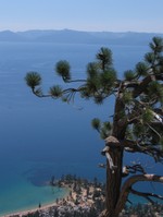
We were a little nervous about topping 8,000 feet our first day, but there was only a thousand feet or so of climbing, so what better way to acclimate to elevation? We took the Mt. Rose shuttle, and had a great deal of fun on top of the ridge on the TRT, even though we were feeling the elevation. The Flume Trail portion was a bit disappointing, and not nearly as scary as we had been warned. Then again, we were riding it on a weekday, so there was little traffic coming at us. The photo at right is a shot of Sand Harbor, from the Flume Trail.
Hole in the Ground
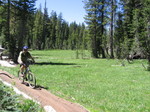
Next up was Hole in the Ground, a fairly demanding loop. This is where I broke my RAM mount and scratched up my new Garmin 60CSx. It was a fun but grueling ride, on a very well laid out trail. 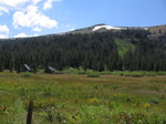 Highly recommended for technical riders. On the left is a nice meadow shot.
Tahoe Rim Trail (TRT) via Round Lake to Meiss Meadows
It seemed like the rides just got better and better. This ride had a nice backcountry feel to it, with great challenges like the granite steps you climb near the start (the cause of my wife’s worst injury of the trip). The ride (a loop plus out and back spur) terminates at the Pacific Crest Trail in the idyllic Meiss Meadows, pictured at right; note the historic cabins. Unfortunately, on the way down, I took a tumble and lost my mojo, and I struggled with even the easiest of obstacles for the rest of the ride.
Downieville Downhill
 Ah, the coup de grace — a 4,000′ descent. We caught the shuttle to the top. (Now I know what you’re thinking — shuttle the first ride, shuttle the last ride, taking the easy way
 out up. Would it help if I said some of our rides involved climbs of almost 3,000′? Hey, if you can do the 4,000′ climb required to make this one a loop, you can think whatever you want. My helmet’s off to you!) Ahem, where was I?
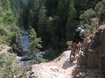
There were some rough cobbly sections early on, and I was still shaky from the last ride, but before we got too far down the fast and fun singletrack, I had found my groove. And man, was it fun. The Third Divide trail is definitely a fast and smooth classic. Our route finished on the First Divide trail, which had at least one precarious section — the photo on the left shows my wife picking her way through it.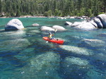
Kayaking Lake Tahoe
We didn’t actually ride everyday, and we did take one day as a rest day, going on a short kayak trip at Sand Harbor (see top photo for the view from the Flume). The image to the right shows how clear the water is, and how badly I can fake paddling.

Thanks for posting the Mt.Rose to Spooner track. We’re doing it next week and it be great to have in the GPS unit!
Gary
You’re welcome. It’s a great ride. The top part was actually my favorite portion of the ride. The Flume was cool though. Be sure to stop and check out the views once in a while. And the ride ends with a fast downhill!