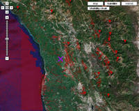
Though I live by the sea, I’m a mountain lover at heart. There’s nothing more exhilarating for me than peak-bagging, and once I’m there, there’s nothing as fun as looking off to the horizon, and figuring out what peaks I’m seeing. Well that just got easier, thanks to a new Google Maps mashup titled Hey, what’s that?
Plugging in your favorite peak is easy. Simply go to the New Panorama tab and navigate via the map interface to the peak of your choice. A planned future addition is to have peak names show up on the map interface to help you navigate once you get close. For now, you can use the map, satellite imagery and the Contours button. Once you get close, there is a button that allows you to fine tune your location, automatically choosing the nearest high point. After that, all you really have to do is name your map, which you can make public. That’s what I did with Cahto Peak, California.
When viewing a panorama, you’ll see a profile on top and a list of peaks to the right. You can click the red triangles on the profile or the peak name to show the peak on the map. Click a triangle on the map to reveal the peak name.
Be sure to check out the visibility cloak. This feature turns a portion of the map red (see above), indicating what can be seen from the peak. Hmm, what else? Did I say that it works in Google Earth too? Or that you can get peak lists generated by phone or email? How cool is that?
Create waypoints of peaks to send to your GPS
As if that weren’t enough, I contacted the developer and asked if he could add the ability to generate .gpx files from the peak results, using GMaptoGPX. And he did! Imagine, just download all the waypoints, head out to climb a mountain and, once on top, use your GPS to figure out the peaks.
Via Google Maps Mania.

So, in a related question…. How do you convert a point in Google maps, or more likely, a point in Google earth [KML or KMZ] to a waypoint for my GPS [Garmin in this case] I’m always finding cool peaks, creeks, some place in a field, that I’d rather just save as a waypoint and then imput into my GPS…
thanks,
dave
Dave,
You can convert KML files to GPX format using GPSBabel (http://gpsbabel.org). Your GPS will accept GPX files.
Second internet tool topo http://www.geocontext.org/publ/2010/04/profiler/en/?
Thanks Baikal!