UPDATE: Read our Garmin Colorado 300 review, Garmin Colorado 400c review and Garmin Colorado 400t review.
Early last month, we let the cat out of the bag on the Garmin Colorado handheld series. I’m expecting the official announcement no later than tomorrow, but here’s a sneak preview for you, replete with specs and lots of eye candy for you geocachers and other outdoor enthusiasts out there. I’ll have more to say next week after meeting with Garmin at CES.
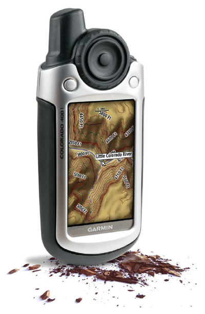
Garmin International is pleased to announce the Colorado, the newest member of the premium handheld line. This rugged unit with a high-sensitivity receiver offers innovative features such as a new Rock ‘n Roller™ wheel for one hand operation as well as the ability to exchange waypoints, tracks, routes and geocaches wirelessly between units. In addition, you can customize your Colorado with five different user profiles: automotive, marine, recreation, fitness or geocache. The SD card slot on the bottom of the unit makes it simple to load optional maps for different types of adventures. The Colorado has a rugged, metal-look and a sleek, slim profile. The Colorado’s detailed mapping and high-resolution color display enhance any outdoor adventure, whether on land or water.

The Colorado is offered in four different variations: Colorado 300, 400t, 400i and 400c.
The Colorado 300 features a built-in worldwide basemap with shaded relief for incredibly enhanced map presentation on the unit. Optional detailed maps can also be loaded using the SD card slot or the 384 megabytes of internal memory built into the Colorado 300.
With the state-of-the-art 3D elevation perspective and preloaded topographic map data of the U.S., the rugged Colorado 400t is the perfect companion for your outdoor adventures. It gives you all the tools you need for serious climbing, hiking or hunting.
The Colorado 400i is your all-purpose guide to outdoor fun. Built-in U.S. Inland Lakes and navigable river maps provide boaters and anglers with shoreline details, depth contours, boat ramps and mile markers for thousand of lakes.
Saltwater mariners will love the built-in detailed BlueChart g2 coverage for the coastal U.S. and the Bahamas in the 400c. The chart detail includes shoreline, depth contours, navaids and port plans.


Availability and expected retail price:
- Garmin Colorado 300 – January 2008, $499.99
- Garmin Colorado 400t – February 2008, $599.99
- Garmin Colorado 400i – February 2008, $599.99
- Garmin Colorado 400c – January 2008, $599.99
Product Features and Specifications
- High-sensitivity GPS receiver
- Innovative Rock ‘n Roller input wheel
- Wireless sharing of user tracks, waypoints, routes and geocaches between units
- SD card slot for optional mapping and user data storage
- User configurable profiles: automotive, marine, recreation, fitness, geocache
- Unit dimensions: 2.4”W x 5.5”H x 1.4”D
- Display size (H x W): 2.55” x 1.53” (3” diagonal)
- Display resolution (W x H): 240 x 400 pixels
- Display type: Transflective Color TFT
- Weight: 7.3 oz with batteries
- Waterproof standard: IEC 60529 IPX7
- Battery type: 2 AA Alklaine or NiMH batteries
- Battery life: 15 hours
- Electronic compass, altimeter, temperature sensor
- Compatible with heart rate monitor and speed/cadence sensor (GSC 10)
- JPG image viewer can display pictures from the SD card
- Supports Geoching.com GPX files for complete cache descriptions and hints

Wonder if scanned and screenshot maps can be calibrated and used? How user friendly is it to accomplish the calibration?
What chipset does it have?
New Garmin…
Ok while having nothing to do with 680 traffic or my daily commute. This does and will fill the gapping hole that my lost garmin MAP70s let when (like an idiot) I left it on the cruise ship when we
Vidar,
Doesn’t look like it but I have to wonder what the cGPSmapper folks can do with this. I don’t know what chipset its using yet.