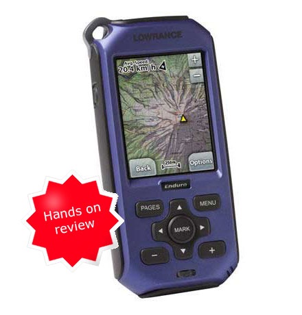
 The Lowrance Endura Sierra
 is the high-end model in the recently introduced Endura product line. It includes preloaded Accuterra™ “high-resolution” topo maps, a trails and POI database and NAVTEQ® roads for the 48 contiguous United States. Turn-by-turn routing is available as an add-on purchase. The Sierra includes a tri-axial electronic compass, barometric altimeter and 4 GB of internal memory. All three Endura models utilize a 2.7” color touchscreen.
The mid-range Safari model uses a standard two-axis electronic compass and drops the internal memory, as well as the Accuterra and NAVTEQ maps, in favor of “detailed hill shading, topographic contours, primary and secondary roads and key POIs.” Contour intervals are 100’ on the Sierra and only 500’ on the Safari! Like the Sierra, the Safari has an MP3 player, video player, picture viewer, headphone jack and built-in microphone for voice notes.
Compare prices on the Lowrance Endura Sierra
On the low end, the Out&Back drops the electronic compass, barometric altimeter, topo maps, and multi-media features (though it does retain the picture viewer).
Lowrance Endura physical characteristics
As you can see in the image below, the Endura series is a bit bulky compared to other new models. Dimensions are 5.1” H x 2.4” W x 1.2” D. The unit weighs in at a relatively heavy 8.1 ounces with batteries. Compare this to 7.0 ounces for the Garmin Oregon 400t.
The unit feels sturdy in terms of construction, and the battery compartment seems well-sealed. There is no wrist-strap included, but there is an attachment point on the upper left corner of the device.
The model I tested was a pre-production unit, running firmware v 1.0.75655 NA Sierra (you can get firmware info by holding down the menu button). My preproduction unit differed in one respect from the final model — “one modification was made during final production to improve the seal on the rubberized cover to the USB and power connections on the bottom of the unit.” Underneath the flap on my unit was a mini-USB port and micro-SD card slot. The power button is on the left and a headphone jack is under a protected flap on the right side.
 Touchscreen visibility and battery life
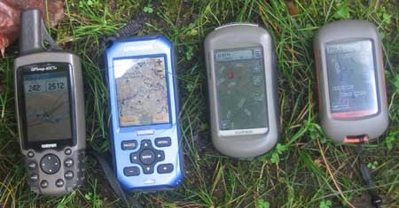
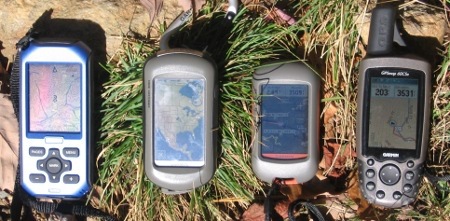
All of the new generation high-resolution GPS receivers suffer from similar visibility problems, although the Lowrance has the brightest backlight of any of them. Of course, that comes at a cost, that cost being battery life. It’s hard to get a real feel for this in a photo, but the image above attempts to compare the Sierra to several other units under light shade. All have their backlight on. The Garmin 60CSx beat them all, but the Lowrance was brighter than the Garmin Dakota or Oregon.
And here’s a photo under bright sunlight…
 I powered up the Lowrance and left it under light canopy one morning to test battery life. It lasted for about 9 hours. This differs quite a bit from Lowrance’s estimate of 15 hours! (EDIT: Okay, the website now says 10-15 hours, and I’m told this is with lithium batteries.) Testing was done with fully charged 2,000 mAh Eneloop NiMH batteries. A red LED flashes at the base of the controls when the battery is nearly exhausted. While this seems like a good way to drain the remaining power, in reality LEDs don’t consume much, so I don’t see it as a big issue.
The battery indicator on the main menu is small and it can be difficult to discern what level of battery life it is reporting.
Lowrance Endura Sierra interface
The Sierra is, well, sluggish. From startup (a full minute) to satellite lock (another 25 seconds) to delays after selecting a menu item (up to several seconds), these patience-trying waits bring not so subtle irony to the name Endura. It was so slow at times that I thought it had locked up, which it actually did twice during my testing.
Hybrid interface
Besides the touchscreen, the Endura series has physical buttons for Pages, Menu, Mark, Zoom in, Zoom out, and four scrolling arrow keys. After using this and the Magellan Triton, I have to say that I’m not a big fan of the hybrid interface, where a unit has both buttons and a touchscreen. I’m sure I would get used to it, but it is quite confusing early on – when to use buttons and when to use the touch screen. There are certain items you can select with the touchscreen, but to take the final step, you must use the “mark” button. Very confusing.
Intuitive and easy access to some functions
Touching the map brings up zoom in and zoom out buttons, as well as options and back buttons. I do like the fact that you can get the options button for any of the main screens by simply tapping the screen. This gives you easy access to key functions such as switching from track up to north up. Other than the noted exceptions, I found the interface relatively intuitive and straightforward.
Backlight
You can control the backlight level by tapping the power button, and you can re-activate the backlight by tapping the screen. Unfortunately, this always engages some function, such as bringing up the options, back and zoom buttons on the map screen.
Data entry
The first time I tried to name a waypoint, I used my fingernails on the keypad with miserable results. Once I stopped doing that and used my fingertips, I had no problems. Characters stay highlighted until you hit the next character, which helps alert you to any mistakes.
Data fields
 Data fields can be customized, but can be difficult to read on some screens. And some items are conspicuously absent — for example, while there is an ETA at Next option, there is no ETA at Destination. Nor is there a total elevation gain option (even on the altimeter screen).
A few other complaints
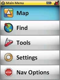
- The Tools main menu item just gives access to MP3 player, photo explorer, video player, which are likely to be of little use to most owners, though I’m sure they would soon learn to ignore this item
- Tracks show up as a double track, which looks like a 4WD road, contributing to the often cluttered look of the map screen
Screenshots courtesy Lowrance
Lowrance Sierra Endura video
The video below goes over use of the map screen:
Tri-axial compass
Thanks to the tri-axial compass, you don’t need to hold the unit level while navigating. You can calibrate it by tapping the compass screen and selecting “calibrate compass.” It then says “rotate compass in all 3 axes until complete,” but (for me) it said “compass calibrated” within a second, so I never had the opportunity to calibrate the compass!
Waypoint, route and track management
It’s easy enough to connect the Endura series to a computer and add waypoints and tracks by dragging .gpx files to the GPX folder. That’s where the simplicity ends though, as there is no compatible desktop software made by Lowrance for the Endura series. Some third-party programs work though, as I had partial success with both TopoFusion and Garmin’s MapSource. These programs might do better once Lowrance issues a fix for their broken GPX files.
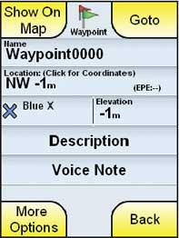 When creating waypoints, you are given the option to add voice notes. This is a nice feature. The first time I used it I was at a signed USFS trail junction, and I was able to add quite a bit of information in the voice note. If you use this feature, speak up, because the built in playback speaker is pretty weak. Other waypoint options are limited; you cannot average, reposition or project waypoints.
You can access / edit current track information by touching the track on the map screen. This allows you to save the track and edit the name. One of the options is to save the last 24 hours, which is nice if you forgot to reset trip info. There is no option to change the appearance or color of a track. Track time data is given in GMT.
Routes are, by default, named sequentially (e.g., ROUTE0002), instead of with beginning and ending waypoint names, although the route name can be edited. Route options are what you would expect – the ability to reverse a route, add points, resequence, etc.
Geocaching with the Lowrance Endura
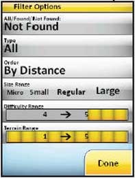 The paperless geocaching features are one of the best things the Endura series has going. Just like most paperless units, you’ll get the description, recent logs, hint, etc. But Lowrance has added something new – built-in geocache filters. You can filter for found, not found, cache type, size range, difficulty range or terrain range.
You’ll need a workaround to send individual caches from geocaching.com, but the best way is to send a bunch with a pocket query .gpx file (premium membership required). Field notes can be logged at http://www.geocaching.com/my/fieldnotes.aspx.
GPS receiver performance
The Lowrance seemed accurate in tests against my Garmin 60CSx. Once warmed up (and that takes awhile), it demonstrated even less “spidering” than the 60CSx. But it takes a long time for initial lock (1 minute, 25 seconds) and a long time to settle down.
I’ve seen reports that the Endura series will fail to update your position on the map occasionally, even though it maintains satellite lock, and I experienced this once myself.
Lowrance Endura maps and POIs
The Lowrance Endura Sierra includes points of interest (POIs) for restaurants, etc. The more important (for a handheld GPS) geographic features database seemed a little light though. On the Appalachain Trail, with plenty of peaks and other interesting features around me, the nearest geographic POI was a mountain 5.7 miles away.
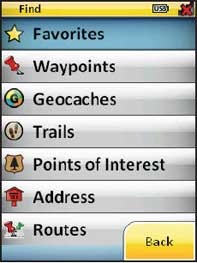 It is nice to have built-in maps though. Yet I should add that it only has 100’ contour intervals – not exactly the “high-resolution topographic maps” promised. It does seem to have a pretty good trails database though. Aerial imagery is only available when zoomed out to 30 miles or more.
As I was wrapping up this review, the MapSelect Online map Store went live. From the site, you can download “imagery,” “eTopo” and “BLM” maps. The cost is $5.00 per product for an area that appears to be about 8 square miles. I did not have time to try these out and, after an unexpected (and unrelated) hard drive wipe (!), I received the message “The serial number attached to your request is already in use.”
Lowrance Endura Sierra pros
- Large screen, relatively bright for a touchscreen
- Pre-loaded topos
- Tri-axial compass
- Voice notes
- Sturdy construction
- Relatively intuitive
- Easy to access options for each main screen
- Good keypad makes for error free data entry
- Paperless geocaching features
- Excellent geocaching filter mechanism
Lowrance Endura Sierra cons
- 100’ contour intervals
- Bulky and heavy
- Short battery life
- Sluggish
- Hybrid interface (buttons and touchscreen) can be confusing
- Cannot turn backlight on without engaging a function
- Some common handheld GPS data fields are not available
- Tracks show on map as double track , contributing to screen clutter
- Tri-axial compass calibration did not work for me
- No desktop software
- Weak speaker
- Track management options very limited
- Slow startup and satellite lock
- Data field font can be difficult to read, especially against white background
Recommendation
I’m not able to recommend the Lowrance Endura Sierra for most users. In a lot of respects, this unit just isn’t ready for the market. Future firmware upgrades could significantly improve the feature set, but that remains to be seen. The only folks who should really consider this are geocachers, and the paperless features (especially the filters, which are not currently found on any other brand) are compelling. You have my caveats though, so you should have a pretty good idea what to expect.
More Lowrance Endura Sierra reviews
- Consumer-authored Lowrance Endura Sierra reviews
are being posted at Amazon
- More Lowrance Endura Sierra reviews have ben posted by consumers at GPS City
- Darren Osborne reviews the Lowrance Sierra
- Another consumer review of the Lowrance Sierra has been posted at CNet
I’ll be posting more hands on GPS reviews as they appear, but in the meantime, here are some…
Other Lowrance Endura Sierra resources
- A PDF version of the Lowrance Endura Sierra owners manual
- Here are a couple of Lowrance forums
- The official Lowrance Endura Sierra web page
Compare prices on the Lowrance Endura Sierra at these merchants:
- Check the current Lowrance Endura Sierra
price at Amazon
- Get the Endura™ Sierra – 10% Off Red Tag Sale! Price shown reflects 10% discount.
at Boaters World
- Find the Lowrance Endura Sierra
for an amazing price on eBay


I’ve owned the sierra for around a month now. Actually, I’ve owned two. The first one needed servicing after a couple days…However, Lowrance customer service is amazing; they’re very easy to work with and don’t talk in circles. They had a new unit to me in less than two weeks. I’ve been geocaching with it and the paperless features are great once you figure them out. The only thing I don’t like is after you upload your field notes to geocaching.com and delete your field notes from the unit, the geocaches saved in your unit which you’ve already found revert to showing as though you haven’t found them. Then you have to go in and delete the found geocaches manually. Perhaps there is a better way to get around this which I’ll discover in the future but for now if that’s my only con, I can definitely live with it. Oh yea, the user manual could use some more info, it’s pretty skimpy. Through previous knowledge and searching the internet I’ve done alright.
Thanks for sharing!
Sucks. Zero support. No real map or navigation abilities loaded.
Look elseware.
You must buy this map chip, and then that map chip. Almost $100 a chip. The tiny mini SD cards get lost in my carpet, and not realistic to change out in the car.
Sounds like a reply from someone with no experience with a GPS unit. I feel for you, this is not a unit for those who have not owned one before. However, this unit does come with all and more options and software than you need. Perhaps you need a little more time to figure it out, as it seems you haven’t been able to tap in to all it’s capabilities yet. Good luck.
I agree that its not a good unit for noobs, but if I’m not mistaken, their map prices ARE quite high.
They sure are, but I’ve yet to find a cheap option by any manufacturer.
I got enough information here that I couldn’t get from their website. I intend opening a business contact with Lowrance to serve my country. Thanx for this enlightenment.