 Garmin barely met their March deadline for rolling out BirdsEye aerial imagery. It showed up late yesterday in the form of updates to their BaseCamp software and firmware updates for eligible units — the Colorado and Oregon series; there remains some question about whether both Dakota models are compatible – the Dakota 20 is for sure (more on that below).
EDIT: We’ve learned that Garmin decided not to support BirdsEye imagery on the Dakota 10, due to its lack of an expansion card slot.
To get started, run WebUpdater and download or update BaseCamp. Once you start BaseCamp and connect your unit, you should get a message asking if you want to create BirdsEye imagery for your device. You can download a low-resolution demo for free or pony up $29.99 for a year of downloads.
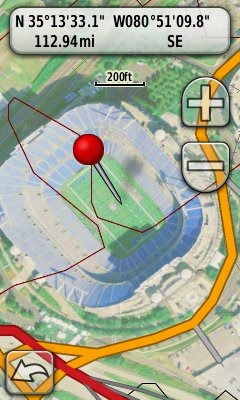
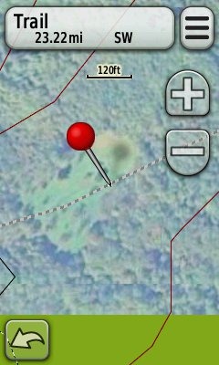
I’m posting a couple of images here. I haven’t used them out in the field yet, but they appear washed out on the screen of my Oregon 400t. The one at left is Panther Stadium in Charlotte; below is a high elevation bald in the Rocky Fork tract, a new 10,000 acre public land acquisition near the NC/TN border. The resolution available for that area does not allow me to pick out forest roads, limiting its usefulness. This is an early test though; other areas may have higher resolution imagery available. In more open terrain (e.g., western US), you might be able to pick out trails and 4WD tracks, even at this resolution.
 I’m still left with some questions and I’ll try to find answers to them. One, as mentioned above, is whether the Dakota 10 is compatible or not. It’s not listed as such, though the Dakota series was mentioned in the original news release announcing BirdsEye imagery, so hopefully it’s just an oversight on Garmin’s part. I’d also like to know the resolution of the imagery in meters/pixel.
Chime in and let us know what your experiences are with BirdsEye imagery.


I’m liking this. The imagery in my area is better than that found in Google Earth. However, I do wish that it used a tile selection method instead of a free-form box selection. It would make it easier to grab areas beside each other, without overlapping selections, and wasting valuable disk space.
Just noticed, occasionaly, Image tiles don’t line up. In one case that I can see everything shifts west about 23m at one point (right around W110 47.000. I’m seeing it around N50, but it appears to run on for quite a long time), leaving a black gap between images. It’s too bad, because for the most part the imaging lines up pretty good with the map data.
Good catch. Hadn’t noticed that. I agree that tiled selection would be nice.
When I click on Birdseye my Basecamp says “no supported device was found”, but I’ve a updated Dakota 20 and is listed on the left of the program…
Now it work!
It’s really cool!
oh soooo new… there have been FREE apps that have been doing this for the garmins for a while now. sure you have to learn how to use them, but nothing new except maybe the area size. been using G-Raster for a while now and very happy with that solution PLUS, I make the map and can send it to all my hiking buds to load so maps are not locked to units. google g-raster garmin
Yes, G-Raster is a great option. Here’s the link in case anyone is interested…
http://moagu.com/?page_id=155
People can read more about the custom map options at http://gpstracklog.com/tag/garmin-custom-maps
forgot to add, you think the image is washed out… using the avail tools, you can load the map into photoshop, adjust contrast and SHARPEN then make the map… cant do that with birdseye. by the way, am i the only one that thinks the logo looks like a ticked off Partridge Family logo bird?
Are there any limitations on the size/coverage area for Birdseye Imagery? In other words, does it bypass the 100-tile limit for Garmin Custom Maps? Can you have both Custom Maps and Birdseye Imagery loaded in your unit at the same time? Can you turn them off independently?
Leszek,
I’m unsure about the 100 tile limit. Yes, you can turn on/off all BirdsEye images and custom maps images independently. They reside in two different folders.
Looks nice but after using it for a while I’m not so impressed. Undoubtedly things will be improved in the future, but for now, the only program that can use such images, BaseCamp, is in its Alpha stage. Never mind what Garmin says, the program isn’t ready for consumers yet. Sluggish and slow, takes for ever to do anything, and this is on an i7 CPU.
(Have been a Nuvi 350 owner since they came out. Trying a new TomTom 730.)
After paying the subscription fee, I tried downloading some BirdsEye images to my Dakota20. Everything seemed to work, according to BaseMap, but I can’t actually see anything on it, or on the Dakota. The unit gives me an error message “Invalid jnx file”.
Overall, I’m not that impressed with BirdsEye. Or the Dakota 20. Or Garmin.
If you go into Setup > Map > Map Information – Select Map, do you see a box for BirdsEye imagery? Is it enabled?
In mass storage mode, can you see a Garmin/BirdsEye folder?
Yes, the BirdsEye folder is in the unit’s file system. In it is a 16KB (!?) file called BirdsEye Imagery 1.JNX. This is on a Mac.
No, there is no box for BirdsEye imagery in the map list. I do have some other free topo maps installed, but there is lots of room for the tiny BirdsEye maps I’ve tried to add. I can’t even see the BirdsEye maps in BaseCamp, even though it says they have downloaded correctly, and my Dakota is registered for them.
It’s a mystery, and I have an email in to Garmin Support.
Thanks anyway. You have a very nicely laid-out site.
Thanks!
You might also try asking here…
https://forums.garmin.com/showthread.php?t=5895
Email support at Garmin can be frustrating, and not work as well as calling them, but you might want to try going direct to this address…
[email protected]
If you figure it out, I’d love to hear back if you get a chance.
OK–figured it out. The files were downloading, but wouldn’t write to the folder (error 1002). Looks like FIleVault on the Mac interferes. Maybe Garmin tries to write directly to the drive instead of following standard procedures.
The imagery is of variable quality, with some good ones. Try Naramata, B.C. for a not-so-good one. Still, nice to have such easy access to satellite pics.
I gather the images stop working if my subscription expires?
Glad you got it sorted out. The imagery should continue to work for that unit, even after the subscription expires.
is birdseye compatable with macs??
Yes, it’s an option of Basecamp, which works well on Macs, except for the Filevault bug.
I downloaded a bunch of images for my Dakota 20 for a trip out west, but found that the small screen and washed out image made them not very useful in the field. They were great back home on the computer though, for planning purposes.
That’s disappointing.
The firmware version 3.30 added brightness adjustments for BirdsEye. have you tried that?
I didn’t get the update until I got back, but yes, the brightest setting does help a bit.
The quality of map images does vary–the poorer ones are near-useless. I think the small screen size and pixel count do hamper use in the field somewhat. Waiting for retina display, here.
BTW,aAfter trying TomTom’s offering, I’m not as down on Garmin after all….