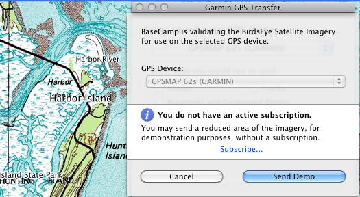
I’ve accumulated quite a few Garmin map downloads over the last few years. Some, like City Navigator or Rails to Trails maps, can be downloaded for a year from the purchase date. Others, like BirdsEye imagery, are offered as an annual subscription. Many of us were reassured about the latter when Garmin told us that “imagery downloaded to your device or a micro-SD card does not expire if your subscription lapses.” Ah, but the devil is in the details.
How to transfer Garmin map downloads after your subscription expires
Garmin BirdsEye Satellite Imagery
Garmin BirdsEye Satellite Imagery is a $29.99 annual subscription plan (though downloaded imagery does not expire) that allows you to transfer satellite imagery to compatible Garmin devices. At this point, the following series are compatible:
Garmin BirdsEye Topo US and Canada
UPDATE: It’s now live and available, and I’m enjoying the hell out of it!
UPDATE 2: How to transfer Garmin map downloads after your subscription expires.
Yesterday morning, I noticed there was a new product, Garmin BirdsEye Topo US and Canada, on the Garmin website. Pretty sweet – for thirty bucks, you can load USGS and NRC topos to newer Garmin handhelds for a year. I’ve been expecting and wanting this for awhile, so I subscribed right away, thinking I’d put it on my 62s and grab a few screenshots for this post. It didn’t quite work out that way, but let’s go over the product details before I get into my experience with it…
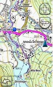
Most topos for handheld GPS units are vector maps; they are made up of lines and points, and look nothing like the USGS topos we know and love. BirdsEye maps are different. These are raster imagery, actual image files, that put USGS topo map images right on your Garmin. Up till now, you’ve had to use Garmin’s custom map process to do this, which can be a hassle, and then there’s that limit of 100 tiles (images) too.
Garmin BirdsEye Select brings raster topos to Europe; US to follow?
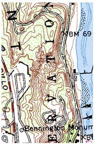
 Well, well. I think I missed the story in Waypoints when I said BirdsEye goes international. What’s new is not the international coverage; it’s the BirdsEye Select products that bring detailed raster topo imagery to Garmin handhelds.
The UK has had such imagery for awhile, and I’m not sure what all the differences are between the Garmin GB Discoverer series (which offers both 1:50K and 1:25K scale maps) and the Garmin Select product at 1:25K. Perhaps some of our friends across the pond can chime in.
What’s interesting to me though, is this bringing us closer to seeing a quality USGS topo product from Garmin. At least I’m hoping that’s the plan.
Improved map controls for new Garmin handhelds
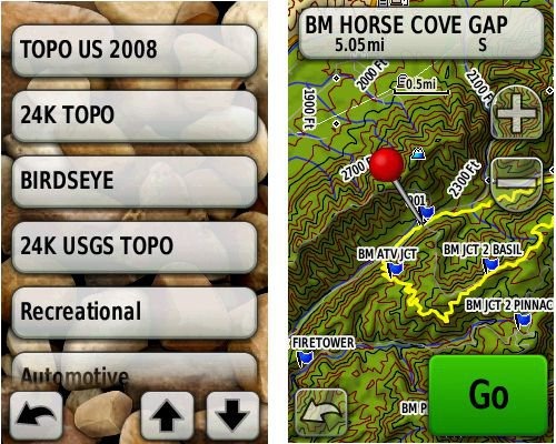 Garmin rolled out several new updates yesterday for the Colorado, Dakota and Oregon series. There were a few fixes, but I want to concentrate on them adding BirdsEye control to profiles. I’m not really sure if you could do this with other map types before; regardless though, I want to point out the granular map controls now available to users of these units, allowing you to easily switch between map types.
Garmin BirdsEye aerial imagery now live
 Garmin barely met their March deadline for rolling out BirdsEye aerial imagery. It showed up late yesterday in the form of updates to their BaseCamp software and firmware updates for eligible units — the Colorado and Oregon series; there remains some question about whether both Dakota models are compatible – the Dakota 20 is for sure (more on that below).
EDIT: We’ve learned that Garmin decided not to support BirdsEye imagery on the Dakota 10, due to its lack of an expansion card slot.
To get started, run WebUpdater and download or update BaseCamp. Once you start BaseCamp and connect your unit, you should get a message asking if you want to create BirdsEye imagery for your device. You can download a low-resolution demo for free or pony up $29.99 for a year of downloads.
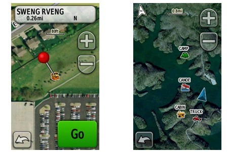
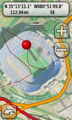
I’m posting a couple of images here. I haven’t used them out in the field yet, but they appear washed out on the screen of my Oregon 400t. The one at left is Panther Stadium in Charlotte; below is a high elevation bald in the Rocky Fork tract, a new 10,000 acre public land acquisition near the NC/TN border. The resolution available for that area does not allow me to pick out forest roads, limiting its usefulness. This is an early test though; other areas may have higher resolution imagery available. In more open terrain (e.g., western US), you might be able to pick out trails and 4WD tracks, even at this resolution.
More on Garmin BirdsEye aerial imagery
 The BirdsEye aerial / satellite imagery subscription program for the Garmin Colorado, Dakota and Oregon series is now official. EDIT: I’ve learned that Garmin decided not to support BirdsEye imagery on the Dakota 10, due to its lack of an expansion card slot. I have a few tidbits to add to my post from last week:
- The $29.99 subscriptions will be available starting this March
- Imagery will include “0.5 meter per pixel resolution in many areas of the United States”
- There is no mention of world-wide imagery in today’s news release, though it was mentioned on the Garmin BirdsEye imagery product page last week, which is unavailable right now
- Another BirdsEye web page has been announced, though it too is currently unavailable
- Image packets will be delivered in multiple resolution levels to avoid pixilation when zooming
- In response to a question, a Garmin PR contact told me “we have nothing to announce re: USGS maps at this time”; my take on that – it’s coming!
Garmin BirdsEye Satellite Imagery coming
 EDIT: I’ve learned that Garmin decided not to support BirdsEye imagery on the Dakota 10, due to its lack of an expansion card slot.
It looks like Garmin is getting ready to announce a BirdsEye satellite imagery subscription program for owners of the Colorado, Dakota and Oregon handheld series. Similar to DeLorme’s Map Library, the BirdsEye program will let you transfer an unlimited amount of satellite imagery and aerial photos to a compatible Garmin handheld for $29.99 per year. Imagery will be locked to one device per subscription; you’ll need Garmin’s free BaseCamp software (version 3.0.0+, yet to be released) and a myGarmin account. I hope to update this post soon with details on when the program will be up and running.
