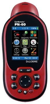
 The DeLorme Earthmate PN-60
 updates the PN-40 with improved battery life, expanded internal memory, and activities (similar to Garmin’s profiles). Power management is one of the biggest improvements, as short battery life was a common complaint with the PN-40.
Other related models
- The DeLorme PN-60w is slated to allow wireless communication between units, following a promised firmware update
- The PN-60w can be paired with the SPOT Satellite Communicator to allow you to send messages from the field via satellite
Note: Much of the following is adapted from my hands on review of the DeLorme PN-60w.
DeLorme PN-60 hardware
The form factor of the unit remains unchanged from previous generations, as you can see at the top of this post. I’m not a fan of the battery compartment thumb screws found on the rear, but fortunately, improved battery life means you don’t have to mess with them so often. The data cable connection is proprietary (bad), but it avoids possible waterproofing issues caused by a mini-USB port (good). Inside the battery compartment is a full-size SD card slot.
The improved battery life results from power management changes such as use of an ambient light sensor to control the screen backlight, and letting the accelerometer sense when the device is not in motion, allowing GPS tracking to be temporarily minimized or disabled. These two features are enabled by placing the device in Power Saving mode.
DeLorme PN-60 interface
The interface remains very similar to previous models, though I believe the main menu has improved graphical elements…
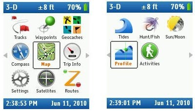
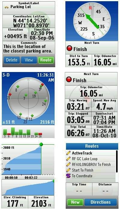
Here are some other sample screens:
Maps and imagery
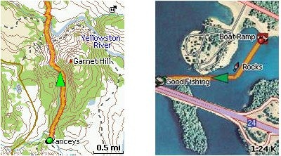
The PN-60 comes with a set of disks containing TOPO USA 9.0 (vector) maps of the US and Canada. It’s now very easy to pick a region and install it to the device. To download raster imagery such as aerial photos and USGS topos to the device ($29.95 annual subscription required), you still have to process them through the TOPO USA software. I covered this in more detail in my PN-40 review. Here are USGS topo and aerial imagery samples (courtesy DeLorme):
 Other improvements to the PN-60 series
Other changes since the PN-40 include:
- 3.5 GB of internal memory (vs. 500 MB in the PN-40)
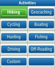
- Activity profiles (Hiking, Cycling, Geocaching, etc.)
- Screen rotation (lets you flip the device upside down; does not work in landscape mode)
DeLorme PN-60 performance
NOTE: The following refers to my field tests of the PN-60w.
I tested the DeLorme PN-60w against either the Garmin GPSMAP 60CSX and 62s on various trips. Most testing was done with the units mounted on the handlebars of my mountain bike, although some testing was also done while hiking. All tests consisted primarily of out and back segments; each track from the devices was examined for track separation errors – how far each track varied on the way out compared to on the way back. I prefer this type of test because it (mostly) removes issues related to satellite constellation variability, aerial photo registration accuracy, etc. It’s merely testing the device against itself, to see how well the track matched up on the way in and then back out a short time later.
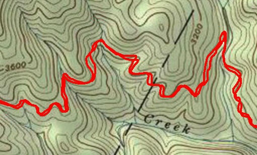
Performance was generally comparable to that of the other units. Sometimes the PN-60w performed better, sometimes one of the Garmin units. I routinely saw track separation errors of 100’ or more when biking, where high downhill speeds often produce greater errors. When hiking, errors maxed out around 40’. I think it would be overkill to post all the tracks here, but to give you an idea what I’m talking about, here is a blown up typical section of a PN-60w track…
In terms of altimeter accuracy, the PN-60w’s Elevation Climbing data field generally recorded total ascent around 10% higher than what was expected based on USGS topo maps.
I did notice occasionally delays of a second or so in response to button presses. It wasn’t often enough to be extremely annoying, but it was certainly enough to notice.
Paperless geocaching with the PN-60
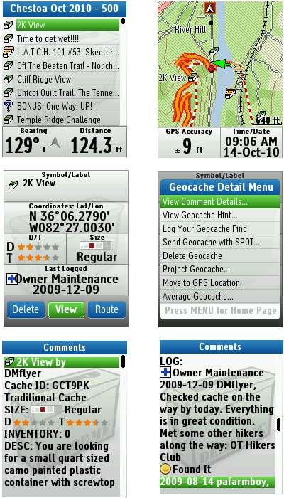
To load caches, you can transfer a single geocache directly from geocaching.com, use DeLorme’s Cache Register widget, or transfer a pocket query via Topo USA. I found the PN-60 series to be as accurate as my Garmin 62s, settling down just as quickly.
Shown below are some geocaching screenshots. Unfortunately you have to scroll down to get to the logs; there is no separate menu item to access them. Perhaps a bigger downside is that there is no ability to filter caches on the basis of difficulty, terrain, size, etc., a feature found in many recent models introduced by Lowrance, Magellan and Garmin.
 PN-60 data management
The PN-60 utilizes a file system for data management. This has advantages and disadvantages. You can have waypoint files for specific areas and track files for specific trails, and only load the ones you need.
 On the downside, you cannot load a file of waypoints and a pocket query file of geocaches at the same time. So you can’t be navigating to a waypoint and see nearby geocaches on the map. There are ways to combine data sources, and get them all into one .gpx file, but then you’re talking about extra prep time.
And you can only load one track file at a time, so if you have trails for a given area set up as one trail per track file, you cannot see all the trails. Again, with data manipulation in Topo USA, it is possible to overcome this.
 Navigating with the PN-60
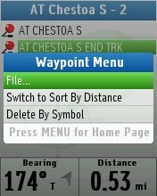
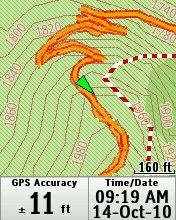
Navigating to waypoints and geocaches, and following routes, functions pretty much as expected. I’ve been spoiled by Garmin’s advanced track navigation feature though, and was disappointed not to be able to display the distance to waypoints along a track. The image at right shows a track being navigated. You can display the distance to the end of the track, but not to waypoints along it. I am told that there are improvements on the roadmap in this regard, although I’m not sure exactly how those will be implemented.
On the road
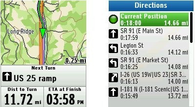
One advantage the PN series has is the built-in ability to do highway navigation. Unfortunately, this is compromised by the small screen, difficulty entering an address, and limited database. I would not suggest using this as your primary auto GPS, nor would I depend on it to get me to a job interview in a strange city. However, hikers, geocachers and others may find it useful for getting them to the trailhead locally. It is probably best used in conjunction with POIs, waypoints or geocaches on the device, as opposed to addresses you have to enter. Don’t expect to be given directions to a specific address either; in looking up an address with a street number of 789, I was given a 10 block range (414-1498) as the best choice for a destination. Screenshots below…
DeLorme PN-60 pros
- Improved battery life
- Bright screen
- File management system allows you to selectively load your data
- Can load aerial imagery, USGS topos and NOAA charts (subscription required)
- Topo USA vector maps easy to load
- 3.5 GB internal memory
- Uses a full size SD card, rather than a micro
- Built-in highway navigation capabilities
DeLorme PN-60 cons
- Small screen
- Battery compartment thumb screws are a pain
- Limited track navigation functionality
- Proprietary cable
- File management system limits you to one file (per type) open at a time
- Weak highway navigation capabilities
- No geocache filtering for difficulty, terrain, etc.
Conclusion and recommendation
Highly recommended for previous DeLorme Earthmate owners looking to upgrade. The PN-60 is a powerful device, with an extensive feature set and capabilities. Nevertheless, I find myself reluctant to recommend it beyond this, partially due to its small screen. I also have concerns recommending it for first-time handheld GPS owners. It isn’t any more complicated than earlier Garmin units, but that company has made some strides with their Dakota/Oregon/62/78 series interfaces. Nevertheless, folks upgrading from a different brand shouldn’t have too much trouble learning the PN-60.
More DeLorme Earthmate PN-60 reviews
- Consumer-authored DeLorme PN-60 reviews
have been posted at Amazon
- Geocacher reviews of the PN-60
- Engadget’s lead editor grows to like his DeLorme PN-60
I’ll be posting more hands on GPS reviews as they appear, but in the meantime, here are some…
Other DeLorme Earthmate PN-60 resources
- The DeLorme Earthmate PN-60 owners manual
- The DeLorme PN-60 message forums are excellent resources
- My DeLorme RAM mount review (this is the mount I used for testing the PN-60 series)
- The official DeLorme Earthmate PN-60 web page
Compare prices on the DeLorme PN-60 at these merchants:
- Check the current DeLorme Earthmate PN-60
price at Amazon
- Get a great deal on the DeLorme Mapping Earthmate PN-60 2.2″ Handheld GPS
at J&R Computer/Music World
- Check out the deal on the DeLorme Earthmate PN-60 GPS
at REI.com, where satisfaction is guaranteed and members get 10% back on eligible purchases
- Get the DeLorme PN-60 at Cabelas.com


I was all set to buy a PN-60 but was told (on another forum) that only Garmin has the ability to have 24k quality VECTOR maps loaded to their units. That the 24k maps available with subsciption from Delorme were all raster.
My understanding is that the with the vector maps the quality at high zoom is better and that you can pull data such as elevations right from the vector maps.
Is this true and can you elaborate? How could there not be 24k quality vector maps compatable with Delorme units? Finally in your review you speak of Garmin’s advanced track navigation, is the distance to waypoint feature available on PN60 and does it really matter if you are importing routes from TOPO software anyhow? Can you explain?
The PN-60 comes with very good quality vector maps. Vector maps technically have no scale, since they can zoom continuously. However, I’d be very surprised if the DeLorme maps were’t based on 24K scale data.
The DeLorme PN-series will not allow you to show the distance to the next waypoint in a multi-point route. But it can dispaly distance to the end of a track or distance to a single waypoint. If you haven’t seen it, this might help…
http://gpstracklog.com/2010/07/navigating-tracks-on-the-new-garmin-handhelds.html
I have been using the DeLorme Topo for about 4 years now. I have Topo 7. The interface can be a little intimidating, but once you get the feel of how it works, the frustration factor goes way down.
I bought this software at a time when it was quite a novel idea to be able to load Satelite images, USGS maps, etc, to your map files. For a yearly subscription, you can load all the data you want.
With all that said, I prefer to use DeLormes maps to all my others (I have subscription to National Geographic for my Magellan, Mapsource for my Garmin, National Geographic TOPO for researching trails.
I do not have the new Garmin 24K maps. The DeLorme maps and Interface is simply superior ot Garmin, and NG TOPO there I said it.
I usually import my Garmin and Magellan tracks to the Delorme maps using Easy GPS software to convert to .gpx format. It is free and it works.
I have come so close to pulling the trigger on the DeLorme PN units more than once, but that screen is simply too small.
All that boring stuff said, to make the point: I really wish DeLorme would develop some new hardware! I think that DeLorme Topo is the best value for mapping software out there for the GPS user, especially the avid hiker.
DeLorme’s Topo product is very powerful. I can see why it is appealing. And oh boy, do I agree that they need new hardware with a bigger screen. Their engineers seem to struggle with power consumption, which may be why they haven’t gone there yet. Plus, as a small company, they are doing good to bring out one major release per year.
With the new products from Magellan and Garmin, it is difficult to see how DeLorme hardware can compete.
I am itching to update my old Vista HCx, but I am not excited about $400.00 – $500.00.
That is why the new Etrex 30 interests me. In truth I am leaning toward the Magellan Explorist 610, Garmin 62s, and the Etrex 30.
Dumb Question time: I’m retired and volunteer at a NGO funded by government agencies to monitor Indian (NM) sites for damage etc and also to submit findings to BLM etc. The GPS info is in UTM and I’ve used a jury-rigged system (Of my own design) CE3, old PDA, Holux (which is really nifty). Anyway I’m not the dumbest or smartest banana on the bunch. Will the PN-60 suffice for desert work–sand, extremely Bright Sunlight, UTM info, decent batteries?
I’ve built my own (and family and friends) computers for years and do read the manuals. So I can handle complex instructions. I want a durable, unit with offroad maps, since we tramp around the NM desert to monitor the ruins. I’d like one that stays in communication with the ‘birds, while in my pocket or backpack. I’d like a fairly fast warm-up. I’m okay with carrying an extra battery.
Like I said, any advice will be appreciated greatly.
DeLormes have a reputation for short battery life, though they did make some improvements in the PN-60 series. Most handhelds will display UTM, and I’m sure the DeLorme is no exception. Personally, I prefer Garmin units over DeLorme, due to the availability of larger screens and more intuitive desktop software, among other reasons.
I haven’t used the DeLorme units myself. However you might also consider the new Garmin Montana. The screen is spectacular, much larger and higher resolution than the PN series. I’m finding it looks its best in the intense sunlight. No backlight is needed in the sun so you should get good battery life and a dual power system – included rechargeable pack or your own AA batteries.
Rich posted links to some more Montana info in this week’s “Waypoints”.
I’m heading out on my second deployment to Iraq. I’m looking for a GPS unit that I can take with me in the event things go sour and am debating between the 62s, PN-60W and waiting for the eTrex 30 (I have the time to wait until the end of 3Q 11). Of course whatever unit I purchase has to have Iraq and Afghanistan map support. Additionally, my wife and I have gotten into geocaching with friends so the unit would get used as soon as I returned. As THE expert on these things, I’d value your opinion.
I don’t even know about being an expert, much less THE expert, but I’ll hazard an answer anyway.
Generally speaking, you’ll find a broader range of international maps for Garmin products. Here are some free ones:
http://gpsfiledepot.com/maps/country/iq
http://gpsfiledepot.com/maps/country/af
And some that will cost you:
http://www.globalmap1.com/16/
http://gpstracklog.com/2010/10/topo-afghanistan.html
I really like my 62s a lot, and think it will likely be at least a bit more intuitive than the new eTrex models. Here’s a current deal:
http://bestgpsdeals.net/garmin-gpsmap-62s-for-329-99/1281/
Hope this helps. Let me know if you have more questions. And thank you for your service.
Thanks for the sound advice (and other tidbits). After thoroughly reviewing your Oregon 450 and 62s posts I decided to pull the trigger on the 62s. I’ll let you know how it works out for me. Again thank you so much for your support!
Glad to help! Looking forward to hearing your thoughts on it.
I don’t see all the fuss about DeLorme Earthmate PN-60.It has everthing you need I think.This is my first time with a GPS of any kind I did a lot of research before I got this unit.I did have to go buy a new computer to be able to load it up.My little AspireOne was just to small to get the job done.I am very happy with my Earthmate PN-60 as far as the screen being small I don’t think it is. I have mine mounted on my Big Dummy Bicycle.I may get to do a trip to Bangor Maine this spring and this GPS should help out a lot getting there.I did look at the Garmin 60s but did not like it.And I look at other Garmin units as well.My trip if I get to do it is over 2000 miles should be a blast too.
Does this unit have a newer rival?
Not from DeLorme.
KDC1956
I have the PN-60 for a short while I don’t think it can be beat my self I use it on my Surly Big Dummy Bicycle and I also use it in mt Ford truck for off road its great for the HWY use it still works great for me and I have not use any of my FREE up load to it I don’t need more than it has on it from the box setup.If I ever need to buy again I will buy the PN-60W next time around but my PN-60 I would not sell it for what I could buy two for I use it most weekends trips I take.
hi!,I really like your writing very so much! percentage we
communicate more approximately your post on AOL? I require
an expert in this area to solve my problem. Maybe that is you!
Looking ahead to see you.
Does anyone in this community have any suggestions for repair of the PN-60, now that DeLorme has been bought out by Garmin? I love the general system of interaction of my PN-60 with my laptop computer running Topo North America 10.0, and refuse to give up on it without a fight. Frankly, I highly resent that Garmin has exterminated the low cost access to large amounts of information for one comparatively low price that DeLorme provided.