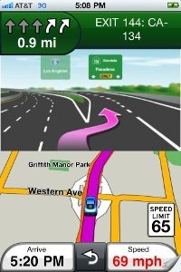
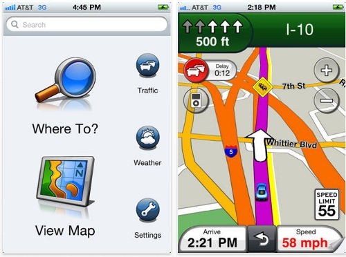
 Garmin has announced their long awaited iPhone navigation application, dubbed the Garmin StreetPilot app (iTunes link), and it is available now! As you can see from the screenshots at left and farther down this post, the interface will be very familiar to any nuvi owner.
The app will retail for $39.99 and include free traffic alerts, lane assist, junction view, and speed limits. According to Garmin, the maps are off-board, delivered over the air, assuring you of the latest maps. They also say that the app will integrate well with iTunes and contacts, allowing you to control music and take a phone call while navigation continues in the background.
Hit the jump for more pics.
Here’s the full news release.


Is there any indication if this software will accept maps available for other units, such as garmin mobile xt previously available on other smartphone platforms?
Not as far as I know, but I expect we’ll see reports if not full reviews in the next few days. I think we can also expect to see apps that utilize other types of Garmin maps, though they may make it hard to load third party maps like those from http://gpsfiledepot.com.
I wonder if the map graphics scale well on an iPad? Are the map updates or traffic update services going to cost like regular stand alone GPS devices?
They are vector maps, so you would think so. But it does say that it runs in compatibility mode on the iPad. Maps are over the air, and traffic is included, so there shouldn’t be any additional cost.
i downloaded garmin streetpilot6.5.2 for my i phone 3gs but it keeps saying searching for satellites or awaiting satellites what is the problem please help
On Android phones, a simple reboot will often help. I came across this recently, which may assist you…
http://www.brighthub.com/mobile/iphone/articles/99689.aspx
I think this App has promise, I believe for being out just under two months, they are on the right track. I do think it needs work though.
THE BIG:
ON-Demand maps: yes, this is similar to the Maps app that comes with the phone that only gives you maps with a cell or wifi connection…kinda. Maps are cached to a point, for the most part if you lose signal, you will still have your overview map(to a point). BUT if you do lose signal WHILE DRIVING, the last thing your going to do is try and hand view any gps map, even if its pre-loaded. What garmin does do, is leave the text directions for viewing with no signal (click the next marker icon on the top left of the screen to view, list directions.) This is really the case with any GPS even with preloaded maps. (This happens to me constantly with my nuvi in the city of chicago on over cast days inbetween tall buildings) and with the cached maps, on my route, I really didn’t notices a difference between this and pre loaded maps, we do have pretty good 3G out here though.
My SOLUTION- I can think of two great options that Garmin could offer here. 1. With Garmin’s older maps and models. States where broken up into smaller sections(since SD cards where much more expensive and rather small) for detailed maps. This would be a great option instead of having a 1.5GB download for the US 48. 2. Two buttons when setting a destination. First is simply ‘GO’ which is exactly how it acts now. Second is ‘Cache & Go’ allow the phone to download a complete detailed map of the current route with a 1 mile radius around the route.
THE EASY FIXES
Spell Check – Garmin decided to use the iphone spell check here, even for street names. This needs to be removed. Wabash and Halsted are not real words, but they are real streets, I shouldn’t have to tell Garmin how to spell. I’ve notices that on newer models that Garmin has really up there game on auto complete, It’s not even available here. What it does have is the option to type a city and zip BUT based your search on just the street address give you results rather quickly, which is rather accurate with a rather big BUT here. I would bet that 99% of uses typing in an address are looking for that specific street closest to them and if not, they will defiantly be typing in the ‘city’ how gamin decided that the street I’m looking for is 116 miles away, when 7 address down the list, there is one 15 miles away, I don’t know. This is fixed very simply by sorting searches by distances (which all current nuvi’s do).
Get it and Go, Less is more –
1. ‘Where To?’ 2. Contacts 3. Joe Smith 4. Search 5. Address 6. Select 7. Go….This is WAY to many menus to go through for an address I already had in my contact list. Seven menu before I even can start moving. As soon as I type in my address if it only matches one place then just GO, if theres 13 Maple Ave. because I didn’t type in a city, in the area give me a list, but I don’t then need to see a map JUST GO!
Favorites – If I put something in my favorites, I know where it is and its there for a reason. If I click it JUST GO, don’t show me a map, I know where it is, it’s one of my favorite places. These are my FAVORITE, put this button on the main screen, no reason this should be buried in menus.
Where did the Detour button go?
Time & Trip data – I enjoy the fact that on my nuvi I can chose to either know what time I will arrive or how long it will take me to arrive.(There are more options, but these are the two I use, I think it can display elevation as well) Also Trip data, average speed, distance to destination, average speed. All this info was available at a push of a button, something so simple, but so useful. All this I’d believe this is an update away, but right now it’s not there.
Let me download custom POIs…I need to know where those RedLight camera’s are 🙂
Map Text size – Not only am I zooming in to see the roads better, but also the street names. If I’m all the way zoomed in, get that texted enlarged, I shouldn’t have to un-mount my iPhone just to read the the street names.
THE GOOD
Google Search is great, nothing I hated more then having to use my Garmin to search for something, it was terrible on the Garmin’s i’ve used, Google knows search and it’s done correct here.
2D Portrait view / 3D Landscape view – I think this was implemented correctly, as much as I like the 3D view, I was never fond of not being able to see side streets when I wasn’t it route mode. In 3D view you can only see names of streets that where perpendicular. Where in 2D mode, you can see the name of all surrounding streets. Great job
I’m a fan of the traffic, my current garmin only has the FM traffic receiver and it works, but mostly only when you don’t have time to make the arrangement to detour.
Voice nav is great, I can see I came into this late, that it was an issue, but I don’t believe so anymore.
Visuals are crisp and clear, same as the current nuvi’s.
LOVE the search bar on the Home screen, I don’t even bother with the “Where To?” Button…just give me the fav button too.
Yes this thing is a battery hog, but I would mention, you can turn off the screen and still receive voice directions. If you have 72 miles till your next turn, I don’t really care what the gps says, just give me a heads up when I’m close, which is does.
It needs work, no doubt about that, but give the developers a chance, it’s been under two months, but as long as Garmin gets in the game, this is turning out to be a superb app…just not yet.
As far as my own experiences, my nuvi has been in the glove compartment for about a week now, and so far I haven’t found a reason to pull it out over the iPhone, it’s one of those the grass is green ideas…I know how to current nuvi is, so i’m looking for that, but since it’s for iPhone, I want more.
Personal Observation – I can see myself 10 years ago getting out of my car in a well populated parking lot. I would first grab my case of CDs and lock them in the trunk. Unmount my GPS and throw it in my bag. Finally grab my phone and clip it to some part of me, cause it was a little big to fit in a pocket. TODAY, I detach my iPhone, slip it into my pocket, and go…I hate to be the barrier of bad news Garmin, but your about to become a software and Map(If you don’t start licensing it from google) company. If I have the option to carry One device (iPhone) rather then Three devices (Cell Phone, mp3 player, GPS) I’m going to. The less I have to worry about, the better. Please don’t look at this app as a side project, but as your future main product.
Great review! Thanks for taking the time to share it.