Earlier this year, Magellan announced a new partnership with National Geographic to bring USGS topo maps to Magellan handhelds. I’m currently testing the eXplorist 510 so I thought this would be a good time to check out the new map downloads.
Like Garmin’s BirdsEye Topo, this is an annual subscription-based plan that runs $29.99 per year for these raster maps (if you aren’t familiar with that term, it’s explained towards the end of this post).
The signup and download process was relatively straightforward, although I have seen cleaner ways to do things with less steps. Still, it worked. You have to use Magellan’s VantagePoint program to download the maps though, and it’s PC only.
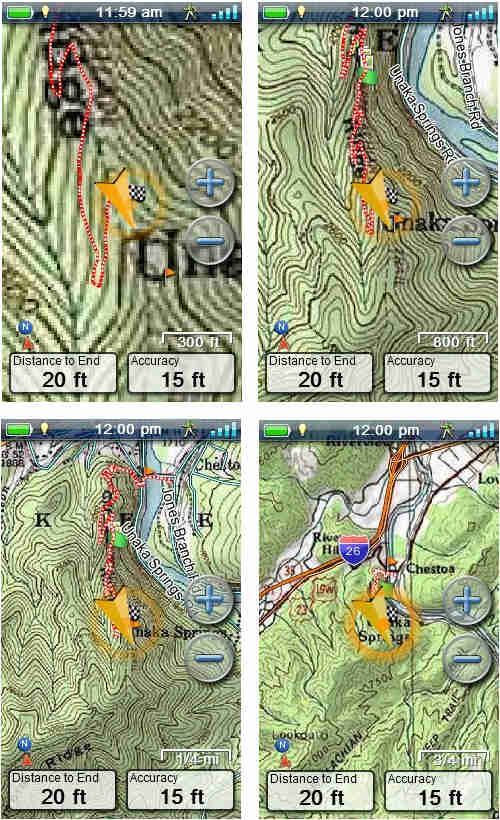
The nice thing about these maps is that they basically put USGS topos on your screen. Combined with an identical paper map, it makes it pretty hard to misjudge you location!
Here are a few images, stepping from the tightest zoom level where these maps are available (300′) to a mid-range zoom, before getting to the farthest out 1:24,000 scale map (1/4 mile), after which it jumps to a 1:100,000 scale map (bottom right)…

Tech talk: Raster vs vector
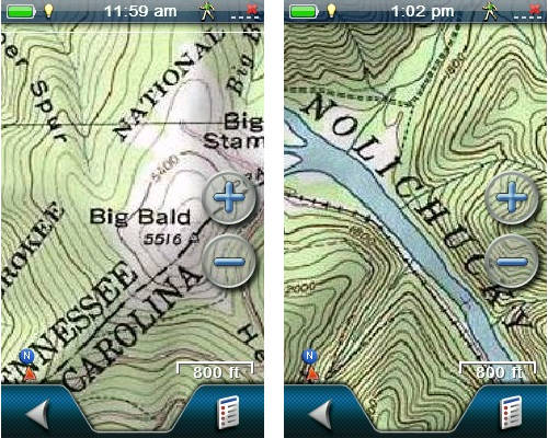
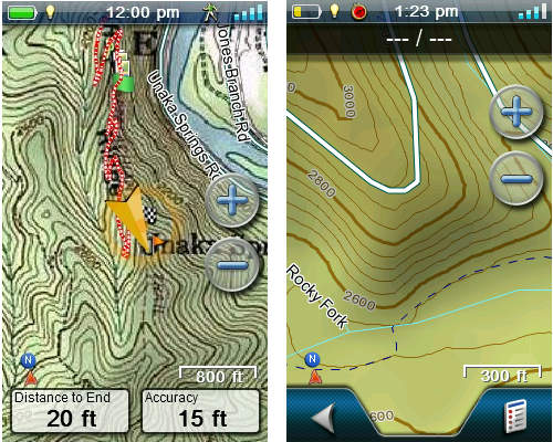
Let’s step back and look at two different types of maps. Raster maps, like the National Geographic TOPOs we are discussing today (screenshot at left below), are made up of images. Because of that, they take up a lot of memory. They are also limited by the fact that you can only zoom in or out so far before the image becomes fuzzy.
Vector maps, like the Magellan Summit Series (screenshot below at right), are made up of data, which show up on your screen as lines and points. Because the files are data and not images, they take up very little memory. They also have an advantage in that you can zoom in and out very far without any blurring.
If you bought a Magellan bundled with the National Geographic TOPO maps, this video will help walk you through how to use the coupon code.
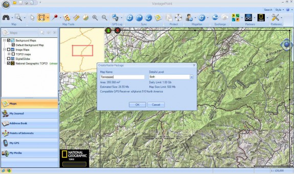
Here’s a screenshot of VantagePoint while downloading maps. Click for a full-size image…
Maps can be saved to the device, an SD card or your hard drive.
Sound off Magellan owners! Have you ponied up for a subscription? If so, what do you think?


How up-to-date did you find the maps for your area? For me, in the LA- San Bernardino area, the map shows huge areas that are now flat and built up with houses as green hills far away in the bush. It looks like a map from the 70s.
I think that is just the way things are with USGS maps.
I’m interested in reviews between Garmin, National Geographic, and Delorme Topo. The most important part of my adventure is planning, and I give the software the top priority. The GPS device is just a way to get me there, and mark some points of interest (ideally with a GPS camera).
I have the Delorme Topo. Wish it did custom maps, and wish it would use free imagery from Google Maps or Bing Maps. It isn’t very fast, and don’t really like the layout. Wish it was better at documenting my adventure.
Hoping for something better.
I haven’t used VantagePoint enough to say, but I strongly dislike DeLorme Topo’s interface. Garmin BaseCamp isn’t ideal but I find it much preferable to DeLorme. They also have good video tutorials for it… http://www8.garmin.com/learningcenter/training/basecamp/
I have Nat Geo Topo installed on my computer and really like the map quality. I am getting ready to replace my Magellan Meridian Gold and have been looking at the Garmin Oregon 450 and also eXplorist 510 because of the ability to load Nat Geo Topo.
While the Topo software looks great on a 21″ computer monitor your screen shots are making me wonder if it is worth having Nat Geo Topo on a GPS.
As of right now I am leaning towards the Garmin.
Thanks for the review.
With either brand, the USGS topos aren’t perfectly clear, but they do put your position on a USGS topo map. That’s the advantage. If you want an attractive, cleaner looking map, go with a vector map.
I find a huge advantage to having both vector and raster maps. Raster maps are the authoritative source and contain all the information available, which might be missing on vector maps. I’ll see old logging roads on my raster maps, but not on the vector maps. If you want to count road/trail curves, raster will be more accurate. When you don’t need all the information, the vector maps are cleaner and nicer to look at.
I typically preoload a lot of vector map information so I have something available. Then I load quads and aerial for specific areas. With today’s technology, I don’t see a disadvantage of raster maps storage requirements.
I like having both raster and vector. Aerial/satellite is great for planning, but not used on my portable GPS device.
Magellan’s screenshot has me concerned. I don’t have the blurry problem on my Delorme PN-40 device. Maybe Magellan will fix that.
My choice comes down to: raster, vector, software.
Good points. Thanks for sharing!
My Triton 500 just konked out, and I am thinking of replacing with an Explorationist 610, I have the Nat Geo State Series downloaded on my Triton. I found they were accurate and easy to read without any distortion. My State Series won’t download to the Explorationist Series, but my saved waypoints will. I have not worked with the NG Topo Series that you have to use now, but I suppose they should be comparable to the State Series. For 30 bucks I can download a lot of custom maps per day for a year.
Hi, I found this post and had a few q’s about my explorist 310…I’m trying to decide on a map, whether it be US SUMMIT Great Lakes, or NG topo subscription. I live in Ohio, I fish, kayak fish/explore, and hike. I also do the same mainly in Michigan and upper Michigan. I like to visit the islands around my area as well. My 310 came with “world map” preloaded. Is there a map between these two that would be best? Details of water would be nice, too. How much data would it be able to hold on any given moment, would it like a whole state? thanks in advance
I’m not familiar enough with the eXplorist maps to fully answer your question, but there is a third option to consider — aerial imagery — which can be very helpful in allowing you to see exact shorelines for islands, coves, etc. Also note that these and NG topo maps may load slower than the Summit series.
I just received an Exporist 510 and have used it and found it very user friendly in comparison to my Garmin. But I would like to have a mapping software that will do what my Garmin would do. It needs to have ATV trails on it and be capable of up loading maps to my Magellan or down loading tracks from the last trip to the computer so I won’t overload the memory or so I can plan future trips. I live in and ride mostly in Utah. There seems to be a couple of possibilities, but my computer skills are weak so I would lean towards the more user friendly program. thanks for your help,