Sunday, March 18, 2012

GPS App Helps Those in Need

donafy

Smartphones aren’t just for Instagram and bird-related games. A smartphone app creator in Philadelphia wants to encourage you to use your device for micro-philanthropy to help the needy. And, all it requires is the push of a button.

This week, the app Donafy–a play on the words ‘donate’ and ‘notify’–debuts on iTunes for the Philly area. Created by a tax attorney in the city who wanted to give people an easier way to help the needy and those on the street, Donafy is meant to make doing your part to help as simple as pressing a button. read more

HERE for Android Adds Indoor Maps

HERE

We’ve talked a lot about indoor location and navigation in the last few months. Undoubtedly, it’s one of the main movements in GPS right now, and there are dozens of companies that are working towards finding a solution to helping people find their way inside of large buildings.

One of the newer names to the indoor location scene, Nokia, announced earlier this month that it will be including indoor mapping of more than 11,700 locations in 76 different countries as part of its HERE Maps app, available for Android. The company hasn’t released a whole lot of information about the indoor mapping or how it works, but from what I’ve seen, it looks pretty decent. Maps are 3D digital renderings of buildings, and users can swipe, swivel and probably even zoom to their hearts content while searching for directions. read more

App Provides Navigation Inside Stores

gpsindoor

Imagine it: you walk into the store with a short grocery list in mind. You input the items in your phone and an app immediately maps out the most efficient route to each item on your list. You follow the flashing blue dot from one item to the next, and the phone vibrates on occasion, alerting you to coupons and advertisements for relevant products as you walk past. This might be the indoor GPS of the future, and it’s available now. read more

GPS App Provides Location to 911 Dispatch

bluelight logo

While not directly related to the kinds of GPS articles we normally write, location accuracy in emergencies is a pretty hot and important topic in the world of GPS and is definitely something worth talking about. This topic has actually been in the news several times in the last year, as it was discovered that 911 emergency calls made from cell phones don’t provide the same location information to dispatchers as landlines.

As it turns out, cell phones really only provide a three to four block radius for possible location to dispatchers, requiring them to either try and figure out where a caller is vocally or to simply search for the person. However, an app has been recently released that utilizes GPS to provide better location to dispatch during emergencies. read more

GPS App Takes You on an Audio Tour


Detour app

Andrew Mason, one of the founders of the popular group coupon app, Groupon, recently launched a new app that utilizes GPS and interesting historical facts and annotations to create audio tours to take locals and visitors to little known locations with local history. The app is very new and is currently only available on iPhones, with Android support expected soon.

“Most of the audio tours that exist today are about what’s popular inside museums,” Mason told US News. “What we are trying to do is turn the world into a museum.” read more

New GPS/Nav App Provides 3D Views

iphone-en

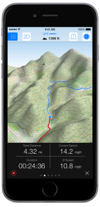
If you’re looking for off-road navigation then you probably have a dedicated GPS device that you use instead of a smartphone. Even with off-network capability, these apps aren’t incredibly helpful most of the time when you’re backpacking in the middle of nowhere, or trying to find your way through a rural area. And, while I’ll never try and sell you that smartphones are better than GPS (they aren’t) if you have an iPhone, this new app might be something worth looking into.

Maps 3D Pro costs about $5 on iTunes, and is actually designed for hikers, cyclists, skiers and outdoor enthusiasts. Not only does it give you terrain and altitude details and download to your phone, but you can actually select what kind of map you want based on where you’re going. Maps 3D Pro draws maps from NASA satellite views, 3D topographic maps, Open Street Maps (for city navigation) and USGS maps just to name a few. You can look at the maps in regular 2D or in beautifully rendered 3D, depending on your needs. You can even zoom and rotate around the 3D version–sort of like a Google Earth for your phone. If nothing else, it’s kind of pretty to play with. read more

New App Replaces Latitude/Longitude with Words

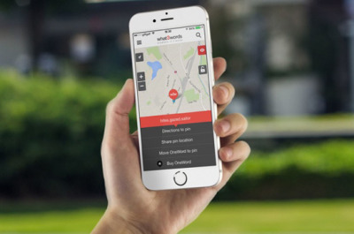
There is no such thing as a foolproof addressing system. Lattitude/Longitude coordinates are extremely accurate, but most people are just confused by the string of numbers. Physical street addresses are easier to understand, but also harder to find in unfamiliar places and often inaccurate. Now, a new startup company is attempting to revolutionize the way we give directions and discover new locations.

The company what3words has taken the entire globe and divided it into a grid of 3 meter by 3 meter squares–a total of 57 trillion squares. Each square is then assigned three random common words to identify that particular spot. The ingenious thing about this mapping system is the level of accuracy without the need for special equipment or any additional knowledge (which is often the case for latitude/longitude). read more

App Helps Navigate Using Pictures

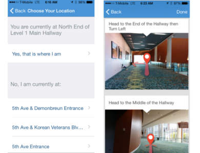
They say a picture is worth a thousand words. And maybe, just maybe, a string of pictures is worth more than a map when trying to navigate indoors. At least, that’s the thought behind a new app platform developed by Ziiio. This wayfinding app takes interior navigation down a different route that, to me, seems like it will be bit more useful in complicated buildings like hospitals or conference centers.

Using Bluetooth technology placed in hallways throughout the select building, the app is able to tell where the phone is and compare it to where the user wants to go. Then, using real pictures of hallways, the app will give literal turn by turn directions to any location inside that building. It doesn’t involve GPS, WiFi or any new technology and it’s so simple, I think it’s genius. read more

Telenav’s Scout GPS App Gets Social Upgrade

scount screenshot

It seems like more and more, GPS mapping and navigational apps for smartphones are getting social integration in an attempt to be even more plugged into our lives. While I’m personally not sure that I approve of this—I mean, do people really need yet another reason to be distracted by their phones while driving?—it seems worth noting regardless.

Earlier this week, Telenav’s navigational app Scout received yet another upgrade designed to push the app to be used as not only a navigational aid, but also as something of a social meetup app. These new features will offer real-time location and ETA sharing within groups, much like Glympse does. Users can also message each other from within the app (which seems like a horrible idea). read more

Map Your Runs and Give To Charity at the Same Time

charity miles

Sure, mapping your daily runs is awesome, and can really help you track your fitness progress and goals. But what if you could do some good as well (I mean, it IS the season for that sort of thing, after all)? Well, a new app released for Android and iPhone (with Windows Phone coming soon) is designed with that idea in mind. Called Charity Miles, this app will track your run, walk, or bike ride and help you earn money to donate to the charity of your choice.

read more