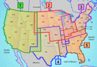
Garmin has released Inland Lakes mapping software for the U.S., described by Garmin as follows:
"From small, local lakes to large ones, this software contains highly detailed data for lakes of almost every size in the continental United States. With exceptional detail — including amazing contour lines on most inland lakes plus high-definition shoreline, river and creek channels, islands, boat ramps, campgrounds, rivers, streams, tide stations and predictions, U.S. Coast Guard aids to navigation, a wrecks and obstructions database, and road data…"
Unlike other recent releases, Inland Lakes is to be made available on SD cards, micro-SD cards and DVD, though the DVD version is not available yet. Five regions, shown at left above, are available on individual cards, or you’ll be able to buy the full set of five on DVD. The list price for the individual regional cards is $116.65. No word yet on the cost of the DVD. More detailed information on the regions is available here.
