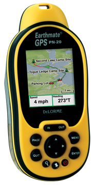
Hands on with the DeLorme Earthmate PN-20
UPDATE: There are now two newer models in this series, the DeLorme PN-30 and PN-40.
Finally, a GPS that displays aerial photos. The DeLorme Earthmate GPS PN-20 does just that, and displays USGS topo maps too. It is incredibly cool to be carrying a GPS that shows your position on an aerial photo. Having said that, DeLorme clearly has some improvements they need to make, and I hope they do, because this is one nifty device. Before we get into the details, let’s get up to speed on aerial photos, and why other GPS receivers lack this capability.
Aerial photos on the DeLorme Earthmate PN-20
Most GPS receivers utilize vector files — basically data files consisting of lines and points. The DeLorme PN-20 differs in that it can also accommodate images, such as aerial photos and USGS topo maps. The technical term is raster imagery, and they eat up much more memory than vector files. For a more detailed explanation of raster versus vector imagery, see What kind of maps can I put on my GPS (and what do you mean by raster and vector)?
Vector lines are redrawn, and therefore appear sharp, at every zoom
level. Aerial photos and USGS topo maps, on the other hand, will only
appear clear at one zoom level. DeLorme probably uses aerial photos
supplied by USGS which are available at multiple resolutions – 1
meter/pixel, 4 meters/pixel, 16 meters/pixel and 64 meters/pixel.
DeLorme appears to be utilizing the one meter/pixel imagery.
