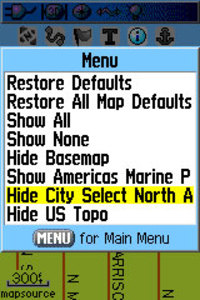
Oftentimes, handheld users will load both highway and topo maps to their unit. Garmin handhelds will show the highway maps by default. The highway map (City Navigator or City Select) for an area must be turned off before you can see the topo map. This is especially problematic when you have a lot of maps loaded and you don’t know the name of the map for your current location.
In the past, I’ve laboriously scrolled through long lists of highway maps, deselecting each one until contour lines appeared on the map. But there is a simple solution. The instructions below are for the Garmin 60CSx, but I’m hoping this works for the eTrex series too. Perhaps someone can verify that and comment below.
From the map screen, press Menu, then Setup Map, and scroll over to Map Setup – Information. You’ll see your list of loaded maps with a check mark next to each one. But rather than de-selecting them one by one, press Menu again and you’ll see two choices – Hide City Select (or Navigator) and Hide US Topo, as shown in the image. Pretty cool, huh?
Thanks to Hogrod on Groundspeak for this tip.

Nice! It works great on my Vista Cx! Thanks for the tip.
A>
Very nice! Thanks a lot
Hi all,
I am not that much of a GPS newbie, I can pretty much find my ways around, but it is my upgrade time now from my nuvi 755T to my 2595LMT. I need help just enough for me to grab the new changes and find my ways around them. I am currently having north america CN which I will remove or disable and load the South African maps. I read on the garmin website that the topo, which I like using in case of my off road trail driving, is not compatible with my 2595LMT. could someone explain why? I also read on some threads that it is possible to have both streetmaps and topo both installed and enabled, by changing the priority of the topo to 31. I understand the whole concept but isn’t there a link or could someone give me a comprehensive step by step to do so including the software I can use to change the drawing priority? (as I understand the topo map is already transparent)?
Thanks a lot in advance for your help guys. Cheers. Mo
Answered at http://gpstracklog.com/2009/09/free-gps-topo-maps.html/comment-page-2#comment-252881