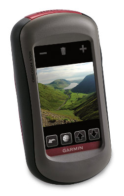
Hands on with the Garmin Oregon 550t
UPDATE: It appears that newer production runs of the 550 series models are now getting the brighter screen first introduced in the Oregon 450 series.
UPDATE 2: The Oregon series is compatible with Garmin’s new BirdsEye aerial imagery.
UPDATE 3: This model has been discontinued and replaced by the Oregon 650t.
The Garmin Oregon 550t is the top of the line unit in Garmin’s touchscreen Oregon handheld line, adding a 3.2 megapixel, 4x zoom, geotagging camera and tri-axial compass to the Oregon 400t’s feature set. It also comes with a battery charger and two AA NiMH batteries.
Like the 400t, this unit is preloaded with 1:100,000 scale topo maps of the US.
Related units
- Step down to the Oregon 550 and you’ll lose the preloaded topo maps
- Or choose the Oregon 450t if you don’t need the camera
- To see how the 550t stands up against other Garmin models, check out my Garmin handheld GPS comparison chart
I’ll jump right in with one of the main attractions of this unit, which is the…
Geotagging camera
 To operate it, you select Camera from the main menu, and you’ll get a screen that looks like the one at right.
It’s a little difficult to see in this image, but there are three icons at the top – zoom buttons and a sun symbol that allows you to switch to a low light option.
You can press and release the camera icon to take a quick auto-focused shot, or hold it down. If you do the latter, a white focus frame appears, which turns green when the scene is in focus.
Using the main menu’s Photo Viewer, you can choose to view photos by Most Recently, Near a Location or On a Specific Date. Choosing near a location lets you select from photos near a Recent Find, a Waypoint, your Current Location or a Map Point.
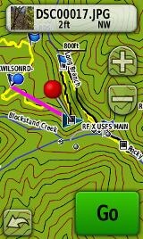 One of the things that interested me was linking photos to waypoints. The process is a bit cumbersome, but here it is:
- Take a photo as described above
- A thumbnail shows at the bottom center of the screen (you can see this in the image above)
- Tap the globe icon on the next screen
- Tap the file name at the top of the next screen (e.g. DSC0017.jpg), as shown at right
- Tap the mark waypoint icon that appears at the bottom of the next screen
- Tap “OK” when it tell you the location was saved as DSCxxxx
- Tap the Edit icon at the bottom of the next screen
- Tap Change Name and give your waypoint a name
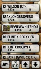 Now Garmin can do better than that, and hopefully they will streamline this process in a future firmware version. But after all your troubles, you get a nice photo waypoint, as shown in the waypoint list at left.
Viewing geotagged photos on your computer
I did not try this with a lot of different applications, but I will share what my experience was. I found Google Earth awkward to use. Once I added a photo, it would retain that lat./long for subsequent images, unless I shut down the application and restarted it. I had much better luck with Picasa and I’ve posted a gallery with a few shots.
Before I leave the camera, I should add that (a) I’m not that great of a photographer and (b) I just grabbed some quick shots – I didn’t take a lot of time and I wasn’t trying to test camera quality, etc. You’ll probably get a better feel for quality by checking the Picasa gallery than judging from the resized image below.

Portions of the following text are adapted from previous reviews of similar models.
Oregon 550t tri-axial compass
Having a tri-axial compass means you don’t have to hold the unit level while navigating. The downside is that the calibration process is more complicated than that for a two-axis electronic compass. It’s the same procedure that is used on the Dakota 20 — here’s a brief video I shot of it. The compass should be recalibrated every time you change the batteries in the unit. Like most GPS receivers with an electronic compass, the 550t also includes a barometric altimeter.
 More maps for the Oregon 550t
While the Oregon comes replete with 1:100K topo maps of the US, why stop there? GPS File Depot is a great source for free 1:24,000 scale topo maps, and they area available for most of the US.
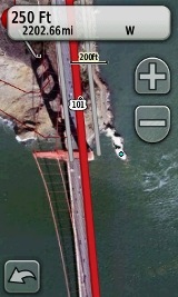
Then there is the recent introduction of Garmin custom maps. Basically, this allows you take any map image you find and put it on your Oregon. Found a park trail map online? Add it to your GPS! The image at right shows a custom map I made from an aerial photo of the Golden Gate bridge. You can read more about this feature by checking out my posts on Garmin custom maps.
Oregon 550t touchscreen display
All of the newer generation high-resolution GPS screens suffer a bit when it comes to visibility, and the 550t was reported to have been improved in this regard. While it does seem a bit brighter and more legible than my Oregon 400t, it is not a dramatic improvement.
My take on the Oregon series visibility issues can be summed up as follows:
- If you are using it as a handheld, you will intuitively tilt the screen for the best view; this sort of use is not a problem
- If you are comparing it to a bright low-resolution color unit like the eTrex series or 60/76C series, you’re going to be disappointed
- I do not recommend the Oregon series for fixed-mount, non-powered use, such as for mountain biking; the visibility just isn’t that good (the Dakota series seems good enough for this use though)
- I do recommend it for powered fixed-mount use (car, ATV, boat, etc.)
Garmin Oregon 550t Interface
Handheld GPS receivers typically offer lots of options, and can be overwhelming for a first-time user. Even so, the Oregon is about as intuitive as they get, and I love the touch screen menus. The main menu is spread across five screens (as shown below); these can be customized, so if you don’t need Man Overboard, you don’t have to display it. 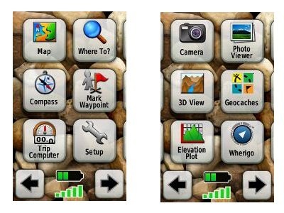
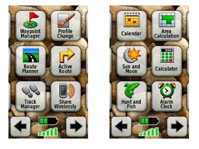
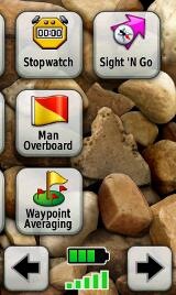
Take the time to do some additional customization and it gets even better. Here are some tips:
- Use profiles – There is a “Change profiles” item on the main menu, and you can create a new one via Setup > Profiles. Tap the new profile to give it a name. Now start changing various preferences. Want track up when geocaching and north up when biking? No problem. The possibilities are nearly endless.
- Rearrange the main menu – Set this different for each profile. I make extensive use of the Track Manager, so that gets moved to the first main menu screen for my hiking and biking profiles.
- Create sun and shade profiles – A great use of this tool is to create a sun profile (perhaps even one for each activity). Create this profile and then go to Setup > Maps > Advanced Map Setup. Set Shaded Relief to Do Not Show to enhance visibility in bright light. If you’re in an area with lots of national parks and forest, you can also improve visibility by getting rid of the green background. Go to go to Setup > Map > Advanced Map Setup > Zoom Levels > Land Cover and set it to Off. Credit GPS Fix with originating these tips for sun / shade profiles.
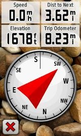
Shown below are the compass and trip computer screens. The data fields can, of course, be customized, as can the background. The trip computer screen can be also switched to show fewer (but larger) data fields.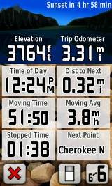
Finally, here’s a random interface tip… When you select a location on the map, a push pin appears. You can now slide the map around underneath the pin, and zoom in as needed, to fine tune the selected location..
Route, Track and Waypoint management
 The Oregon series has excellent route, track and waypoint management tools, including:
- Waypoints – The ability to project a waypoint, and to reposition one at your current location.
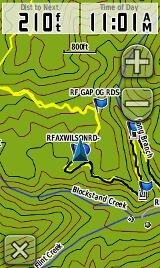
- Tracks – You can choose to hide or show tracks on the map and give them a custom color (17 colors are available). The image at the right shows a track in yellow (a record of a previous trip).
- Routes – You can view a map of the entire route, edit the route, reverse it and view an elevation plot.
Geocaching with the Oregon 550t
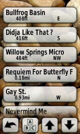
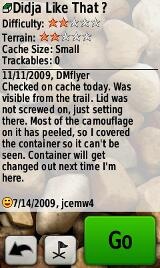
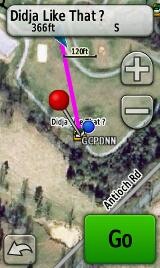
The Oregon is set up for full paperless geocaching support, meaning you can see the description, logs, and hint, and you can log your attempt (find, DNF, etc.) for later transfer back to geocaching.com. Speaking of which, full access to these features requires a premium membership at geocaching.com. Shown below, clockwise from top left: Closest geocaches, geocache description, menu for a specific cache, and custom preview map made from an aerial photo…
Wireless data transfer
The Oregon 550t is capable of wireless data transfer with other compatible Garmin units. You can transfer waypoints, tracks, routes and geocache summaries (paperless caching details cannot be transferred).
Garmin Oregon 550t pros
- Built-in geotagging camera
- Tri-axial compass
- Barometric altimeter
- Great touch screen interface
- Ability to customize display and menus using profiles
- Excellent track management tools
- Paperless geocaching support
- Availability of free maps
- Accepts Garmin custom raster maps
Garmin Oregon 550t cons
- Much poorer sunlight visibility than eTrex and GPSMAP color units
- Ability to modify photo waypoint name needs improvement
Recommendation and conclusion
Recommended. The Oregon 550t is a great workhorse for those who can afford a high-end handheld. The Oregon interface is very user friendly and it has a lengthy feature set. It is an excellent choice for geocachers and hikers, and works well for fixed mount use as long as there is an external power source (ATV’s, boats, 4WD’s, etc.). I don’t recommend it for non-powered, fixed-mount use, such as for mountain bikes. For those looking for a unit with more visibility, or one lighter on weight or the wallet, I heartily recommend the Dakota 20.
More Garmin Oregon 550t reviews
I’ll be posting more hands on GPS reviews as they appear, but in the meantime, here are some…
Other Garmin Oregon 550t resources
- A PDF version of the Garmin Oregon 550t owners manual
- GPS Fix is a blog that focuses on the Garmin Oregon and Colorado series
- A Garmin Oregon message forum
- This tool will show you how the Oregon 400t compares to other mapping units
- The Garmin Oregon wiki has an Oregon FAQ
- Garmin Oregon training videos
- The official Garmin Oregon 550t web page
Compare prices on the Garmin Oregon 550t at these merchants:
- Check the current Garmin Oregon 550t
price at Amazon
- Get the Garmin Oregon 550t at GPS Now, where shipping is free on orders over $99 (and the upgrade to overnight shipping is dirt cheap!). Order by 5 p.m. Central Time for same day shipment
- Check out the deal on the Garmin Oregon 550t GPS
at REI.com, where satisfaction is guaranteed and members get 10% back on eligible purchases
- Get the Garmin Oregon 550t
for an amazing price on eBay


I have a 550, so this most likely works the same way as the 550t.
There’s already a more streamlined way to associate a photo with a waypoint than the way you outline it here. At least I think it’s more streamlined.
Get into the Camera app. Take your photo. Get out of the camera. Mark a waypoint. Click Save and Edit. Edit the name. The next button in line is to associate a photo. Touch that. On mine, the photo I just took is always the lower left one. Touch that photo. Confirm if the preview is acceptable. That takes you back to the waypoint edit menu, where your next button is to change the symbol…
I will have to try it your way. I didn’t know it could be done that way.
It would be nice if I could actually TAKE a photo from within the Waypoint editor. Or generate a waypoint from the photo, since it’s geotagged.
Oh, another neat thing:
The Trip Computer screen can be skinned.
The little icon at the bottom of the trip computer screen 2nd from left. Kinda looks like a slider switch. Touch that and you get a screen that says Select Dashboard. The Geocaching Dashboard has a pic of Signal the Frog and a pointer to the nearest geocache from where you are. Even if you’re not Navigating to one.
Just remember that the Dashboard selected is tied to the Profile you’re in, so if you get out of the geocaching profile and into the Automotive, then your dashboard may be different.
One last tip.
I used mspaint on windows to create a solid black jpg. I copied it onto the unit. It shows up as a photo when selecting wall paper.
I couldn’t find a way to not select any wallpaper, and the black seems, to my eyes, to make some of the visibility improve.
The 550 and 550t both send the full cache descriptions when sending geocaches to another compatible units.
@Mark – Thanks for the tips. I’d love to see you compare the number of steps for a photo waypoint and report back!
@BBosman – So you get the description including terrain and difficulty, but not recent logs?
I’m not sure about logs and don’t have a second GPS handy to test it with, but description including terrain and difficulty, and also the hint are available.
Ok, how did you get that map to look like a satellite photo?
http://www.garmin.com/garmin/cms/cache/offonce/us/onthetrail/custommaps
Nice review of the 550 – though I don’t agree with the “Not for bike use” recommendation. Agreed there are brighter units available, but I use my 400t on my mountain bike all the time – but in order to make best use of it I have 2900 mAh rechargeable AA’s installed, and backlight set to permanently on. Doing this the view from the handlebar mount is just fine in direct sunlight, and after 6 hours of not being turned off there is still plenty of battery left.
Ah, guess I should order some 2900 mAh’s. What brand are you using?
Just found this informative review and I am curious if 6 months later anybody that actually has used one has anything positive or negative to add to the consideration of a Garmin Oregon 550t ?
or something better to consider…
thanks in advance.
Despite the lower product number, the Oregon 450 is newer and has a much better screen. But no camera.
http://gpstracklog.com/2010/04/garmin-oregon-450-review.html
Do you have to pay extra for boat maps for this unit? How much would that cost? What boat maps does it come with? Thanks
It doesn’t come with any. How much they would cost depends on what you want. Inland lakes are cheaper than the coastal charts…
http://www.garmin.com/garmin/cms/us/maps/onthewatermaps
For on the water use, I’d look at the Oregon 450, which will be much easier to read in the bright conditions you’re likely to encounter. Another good choice would be the GPSMAP 78sc. It has no touch screen , but does come pre-loaded with some coastal charts.
Thanks Rich! Do you know which type of marine maps from the Garmin list that the 78sc comes with? Might be barebones maps that are too basic to do boating with. Thanks again
The specs say BlueChart g2. Beyond that, I’m not sure.
Why it is not recommended for mounting it on a mounting it on a mountain bike?
thanks
Because the visibility isn’t that good. A better choice is the Oregon 450, though that model’s improved screen is supposedly being incorporated into new production runs of the 550 series.
Too many choices! I’m a day hiker who would like to download topo’s and trails from my Mac to the GPS and maybe upload after the hike. I don’t need a camera. Do you think the Oregon 450, the Dakota 20, the GPSMAP 62s or something else? A lanyard might be ok but the carabiner sounds better. Thanks for your help.
They are all good units. For hiking, I’d go with the Oregon 450 or 62s. This post may help…
http://gpstracklog.com/2010/07/garmin-gpsmap-62s-or-oregon-450.html
How much is this in the Philippine Market?
How much is Oregon 550t in the Philippine market?
No idea.
do any of this price range units have 911 call button ?we hike, mtn bike, mtr cycle, kayak…have found a couple used units at a good price, just wondering…fyi im 64, partner is 52 both female:) tks!
I am at my wits end and I am hoping you can help me with an issue I have had for years with my 550t. I use it to horseback ride in the national forest. My routine is to turn it on while I am saddling and let it lock on to satellites. Once it is on and satellites locked, I go to setup then to reset and then hit reset trip data and clear current track. I then to to my trip computer and make sure everything is zeroed out. However, within a minute or so, the trip odometer starts moving and I have not taken a step yet. In addition to that, when I go to the map to view our tracks, there is a solid line going from the cursor back to my home and it adds that distance (as the crow flies) to my track! So if our trailhead is 21 miles from home and we do a 6 mile ride, the trip odometer says we rode at least 27 miles plus additional movement when we aren’t even moving. Sometimes it says we have riden 43 miles and since we only rode 2 hours and horses walk at an average of 3 mph, it should be reading 6 miles. I have searched the Garmin website and cannot find anything on this topic. I have done software updates several times and it continues to do this. Are you familiar with this issue? Is there a troubleshooting website for my unit I can go to? Or a GPS wizard out there that can help me? I would appreciate any help you can offer.
I am at my wits end and I am hoping you can help me with an issue I have had for years with my 550t. I use it to horseback ride in the national forest. My routine is to turn it on while I am saddling and let it lock on to satellites. Once it is on and satellites locked, I go to setup then to reset and then hit reset trip data and clear current track. I then to to my trip computer and make sure everything is zeroed out. However, within a minute or so, the trip odometer starts moving and I have not taken a step yet. I go back to setup and clear it again and multiple times and once in a while it works but mostly it does not. In addition to that, when I go to the map to view our tracks, there is a solid line going from the cursor back to my home and it adds that distance (as the crow flies) to my track! So if our trailhead is 21 miles from home and we do a 6 mile ride, the trip odometer says we rode at least 27 miles plus additional movement when we aren’t even moving. Sometimes it says we have riden 43 miles and since we only rode 2 hours and horses walk at an average of 3 mph, it should be reading 6 miles. I have searched the Garmin website and cannot find anything on this topic. I have done software updates several times and it continues to do this. Are you familiar with this issue? Is there a troubleshooting website for my unit I can go to? Or a GPS wizard out there that can help me? I would appreciate any help you can offer.