 A year or so ago I changed my tracklog settings to one point per second, which gave me more accurate trail mileage and ascent numbers. The problem is that most tracklogs are limited to 10,000 points, which means it rolls over to your archives in less than three hours. So you get home, try to download your track, and find that part is in the active track and part is in the track archives.
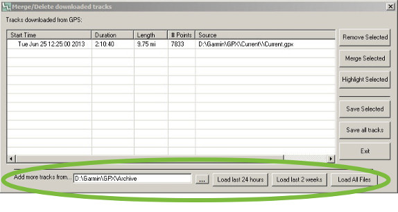
Now there are many ways to handle this, including manually merging tracks, but here is the simplest solution I’ve found. It’s no secret I’m a fan of TopoFusion (which has a fully functional free version), and even though I switched to a Mac a couple of years ago, I still keep a Windows laptop around for TopoFusion — I like it that much. One of the reasons is its awesome track download dialog, where I recently noticed the “Add more tracks from” section circled above. Note that it’s already showing the current track as downloaded.
Once you choose a part of the archive to download, they’ll also show up in the dialog, as shown below.
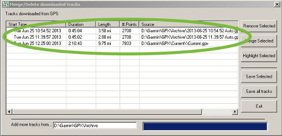
Archived tracks have been added to the download tracks dialog.
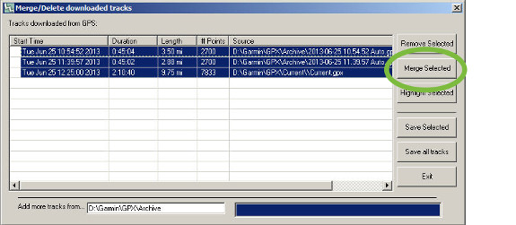
Now all you need to do is highlight the tracks you wish to join and choose Merge Selected. Click Highlight Selected to view the merged track on the map and then click Save Selected to save it.
Merging current and archived GPX track files
Are you using a one second tracklog interval? How do you handle this issue?


Interesting! I also use TopoFusion occasionally, and I have never seen this menu, as I simply drag and drop my GPX files and edit them on the screen.
I was a huge fan of the software initially, but have become less enchanted as many of the available maps are poor quality or simply do not work. (Yes, I have the most recent version)
Hi Atlas,
You have a fair point. Right now there’s an issue with the Nasa server — which TF uses to download both Landsat and elevation tiles. It seems to have gone away, so I am working on a replacement.
It takes constant work, but we try to provide as many map servers as possible (like 3 topo map servers, 3 color aerial) so that whenever one or two are experiencing difficulties, there are always other choices.
Anyway, thanks for the comment.
Scott (author of TF)
Gave this a try as it looks like it could be a better approach to combing tracks. No go for me. The “Add more tracks from” dialog doesn’t appear at all. The free version isn’t exactly fully functional either as there is a 3 file limit.
Hi Steve,
Which GPS are you using? Only some GPS units archive data in the way that TopoFusion can pull and combine. Almost all newer Garmins should have those buttons enabled. Older ones, and Magellan units are not supported in this way, though.
Thanks,
Scott (author of TF)
I have a Garmin 60csx. I keep a folder full of all the archived GPX tracklog files going back to the day I bought it though.
Steve,
Right, the 60CSx uses the old Garmin proprietary protocol to transfer tracks, rather than the Current.gpx and such that newer units use. The track archiving feature (to the SDcard) was added as an afterthought, in a firmware update.
I think if you have the SD card with an archive of tracks you should see the “Add more tracks from…” dialog, albeit with a few less options, but it should be there.
Scott
Scott, thanks for taking the time to respond to comments. Keep up the great work!
I use the Join Tracks function in MapSource. Think BaseCamp can do as well, but who uses that?
I create tracks and roads for RG Philippines, a voluntary group creating GPS maps for the Philippines, we use GPSMapedit for editing the data, which is great for joining and splitting tracks. It also allows us to match our tracks as against Google Earth and Bing maps.
I am currently using a Nuvi 765 gps for creating tracks, and the secret buttons to allow 1 sec tracks. It is getting old now due to the heat and climate here, so I am looking for a replacement GPS, but also which allows the 1sec tracking with reasonable accuracy. Any suggestions please?.
I did read about the car vent mounting for the GPS, it is our experience here that due to the climate again, this mount severely increases condensation into the unit, which does mean an early death on the electronics internally for the GPS.
Thank you for reading, and hopefully you can give me some good advice and guidance.
John
I don’t know if you can do that with newer nuvis or not. Any Garmin handheld will do it, but most won’t function like a nuvi.