 There is a wealth of Geographic Information System (GIS) data available on the web — everything from public land boundaries to international contour files. It is amazing what you can find. A few examples:
- I live in an area dominated by private timber lands. I found private timber company boundary files offered through this website.
- Looking around for public land boundary files, I discovered that the California Department of Fish and Game owns a series of ecological reserves. Not only did I learn about this little known treasure, I found boundary files as well.
- I was fortunate to be able to visit Ecuador a year ago. I used files from the GIS Data Depot to create a contour map of the country, that I was able to load onto my GPS receiver. I was able to find other sources showing roads, streams, cities, provincial boundaries and major volcanoes
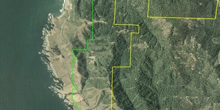
GIS files are most commonly found in either .shp (shapefiles) or .e00 formats. Unfortunately, few consumer-level GPS mapping programs allow you to utilize GIS files. OziExplorer is my favorite program for working with GIS files. Using it, you can convert these files to tracks and points, and even display this info on your GPS. Another program, ArcExplorer, is a free GIS viewer, but it lacks GPS compatibility. The image, to the right above, was captured from OziExplorer. It shows public land boundaries in green and private timberlands in yellow, superimposed on a color aerial photo.
It’s worth doing an online search for GIS data for your favorite areas to explore. Many counties, and probably all states, have GIS sites online. Try searching for "place name" combined with either GIS, shp or e00. Here are some other places to start looking:

Not sure if you’ve seen this – http://web.295.ca/gpz550/OziToGoogleEarth/
But it’s a tool for going from Ozi or a Garmin GPS to Google Earth. I don’t have either, so I haven’t tried it out. Seems interesting though.
By the way, enjoy the site immensely.
Thanks DT. I haven’t tried the Ozi to GE converter yet, but it looks useful. Hey, I love the “About the site” quote on your blog. I’m with ya on that one.