Sunday, March 18, 2012

Imagery sources for Garmin custom maps

Garmin-custom-map-DC There are a lot of new map makers out there now that Garmin has opened the door to custom maps on their latest generation handhelds.

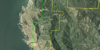
And the results are cool. Just don’t expect those people standing around the Jefferson Memorial to be in the same place when you visit!

The process for adding aerial photos and topo maps is simple enough, once you find the imagery. To get you up and running faster, I’ve posted a list of sources for aerial imagery and various types of maps below. But first, let’s look at some of the acronyms and terms you’re bound to come across as you delve into this…

read more

Source for U.S. Forest Service topo maps and vector files

USFS topo map
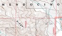
A decade ago, B.G. (before GPS, at least for me), I lived in a part of the Southern Appalachians surrounded by National Forests. I loved exploring the area by mountain bike, and while I wasn’t yet into GPS, my love of maps was already deeply ingrained.

Not yet to the point of filling my hard drive with maps, I instead had a wall full of USGS topo quads, the collars cut from them, detailing a mosaic of the regional landscape. But one day my good friend, fellow biker and map junky, Sparrel, told me about U.S. Forest Service (USFS) maps.

The image above shows a portion of a map near my new neighboorhood, the Mendocino National Forest. Note that the map is brown and white, even though this is a heavily forested region. Unlike USGS quads, these maps don’t show vegetation. What you gain though, are Forest Service road and trail numbers, gate locations, and more legible boundaries. Sometimes these quads are even more up to date than the standard USGS 7.5’ series. Once I discovered these, I was well on my way to acquiring a second set of topo maps for the region!

I recently discovered a great portal for USFS maps and vector data. I stumbled across this via the OziExplorer message forum. They don’t have all the USFS topos, but you might want to check it out to see what they have for your favorite stomping grounds.

read more

NAIP aerial photography

Naip_aerial_photo_mendocino

The Map Room recently covered the National Agricultural Imagery Program (NAIP). Now don’t be confused by the Agriculture part of the name, because the NAIP is of value to a much broader audience. NAIP offers very recent, natural-color aerial imagery of almost the entire U.S., at a relatively high resolution. Full county mosaics are $50. For my county, there is a 2006 image with a resolution of 2 meters/pixel, and a 2005 image at 1 meter/pixel. The image at left, of the Big River estuary and Mendocino, CA, is supposed to be 2 meter resolution. The resolution doesn’t look quite that sharp to me, but nevertheless, I can make out recent changes in logging roads in the area I frequent for mountain bike rides. The image to the right below, shows a 3-D view with waypoints, that I created using OziExplorer.

Ozi_3d_with

The color county mosaics are in MrSID format. You can use OziExplorer to work with these files, and the NAIP website lists several viewers. Quarter quadrangles are available in GeoTIFF format. Here’s the latest (2005) aerial photo coverage map for color county mosaics.

Unfortunately, we’re dealing with the feds here, so ordering is a pain and delivery is slow.


Using GIS Data with GPS

Aerial photo with GIS boundary filesThere is a wealth of Geographic Information System (GIS) data available on the web — everything from public land boundaries to international contour files. It is amazing what you can find. A few examples:

  • I live in an area dominated by private timber lands. I found private timber company boundary files offered through this website.
  • Looking around for public land boundary files, I discovered that the California Department of Fish and Game owns a series of ecological reserves. Not only did I learn about this little known treasure, I found boundary files as well.
  • I was fortunate to be able to visit Ecuador a year ago. I used files from the GIS Data Depot to create a contour map of the country, that I was able to load onto my GPS receiver. I was able to find other sources showing roads, streams, cities, provincial boundaries and major volcanoes

GIS files are most commonly found in either .shp (shapefiles) or .e00 formats. Unfortunately, few consumer-level GPS mapping programs allow you to utilize GIS files.  OziExplorer is my favorite program for working with GIS files. Using it, you can convert these files to tracks and points, and even display this info on your GPS. Another program, ArcExplorer, is a free GIS viewer, but it lacks GPS compatibility. The image, to the right above, was captured from OziExplorer. It shows public land boundaries in green and private timberlands in yellow, superimposed on a color aerial photo.

read more