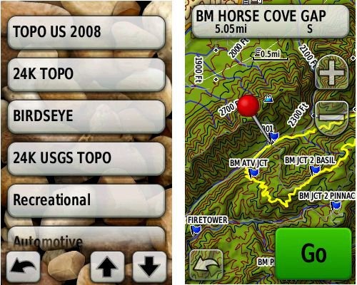
 Garmin rolled out several new updates yesterday for the Colorado, Dakota and Oregon series. There were a few fixes, but I want to concentrate on them adding BirdsEye control to profiles. I’m not really sure if you could do this with other map types before; regardless though, I want to point out the granular map controls now available to users of these units, allowing you to easily switch between map types.
You can see from the image above that I’ve created profiles for the following map types:
- Topo US 2008 – This is Garmin’s 1:100,000 scale topo map, pictured above at right
- 24K Topo – For this I’m using free maps available from GPS File Depot
- BirdsEye – This is Garmin’s new aerial imagery
- 24K USGS Topo – I’m using TopoFusion Pro to send these to my Oregon; they are created as Garmin Custom Maps
You can create custom Profiles on the Oregon series via Setup > Profiles > Create New Profile, then tap the new profile to edit the name. Then enable the profile and go to Setup > Map > Map Information. Enable the map you want for the profile and disable the rest. On your main menu, you may want to move Profile Change up. Do this by going to Setup > Main Menu; tap Profile Change and then tap an icon to trade places with.
Links for the new firmware and a discussion of the update can be found at Groundspeak.
Related topics:


Yes, you could create map profiles with different map types selected before. That was one of my big uses for profiles. The Auto profile would activate city navigator. Hiking profile would activate the topos.
Yeah, I was thinking that might be the case. Guess they just forgot to enable that for BirdsEye, huh? It seemed like a good thing to remind people about though, especially with so many types of maps and imagery available now.
I just wish there was an easier way to change maps WITHOUT changing profiles. When I’m hiking I like to keep all my settings the same but I change maps often. Using this method I need to make sure all the profiles have the same setup.
I think that when you create a new profile, it inherits everything from the one you were in. So you could set one up the way you want, then create new ones and just change the maps/imagery.
My question is, by using the City Navigator in SD format (and for the purpose of biking) can I still download cue sheets to my Oregon 450? And when I simply just go biking and trace a route as I ride it, can I uplaod it to my computer along with all the data of my ride?
What format are the cue sheets in? GPX? If so, they should work fine. And yes, you can transfer your ride data back to your computer.
Maybe I am missing something here with activating different maps? From what I can see when you use MapSource to load maps you have to select all of the maps that you want to have in your Garmin (mine is GPSMaps 78s ver 2,80 firmware) at a given time since it erases previously downloaded maps. When I do that and pick “Setup Map” then “Select Map” I only see 3 possible maps to enable. Two are the pre-loaded maps and the third is the entire collection of maps I downloaded with MapSource. I don’t see how you are able to separately enable the Topo or Ibycus maps for example as it seems to be all or nothing with the group of downloaded maps. I am using the internal memory not a mini-SD card for my downloads at the moment. Is there something different I should be doing in MapSource to get each map listed separately so I can enable them one at a time?
Transfer a set of maps and then, while connected to your computer, navigate to the Garmin drive. Change the name to something else, like TopoCanada.img. Now you can transfer another set of maps and rename them. And so forth.
That was quick! Aha! Now I understand and tried it out, works perfectly. Thank you very much, now I can cycle through some of the free maps you have pointed out.
Glad to help!