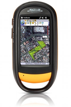
 A little over two years ago, MiTAC purchased the consumer products division of the old Magellan Navigation company. The latter went on to become known as Ashtech, continuing to sell professional grade GPS receivers under the MobileMapper brand. I don’t know if there was a two-year non-compete clause or if that doesn’t apply in this case, but MiTAC’s Magellan GPS is back in the game as of today, announcing the Magellan eXplorist PRO 10.
It appears to use a hardware platform based on the consumer-grade eXplorist 710, a device that I thought had a great interface. Hardware is where the similarities end though, as the PRO model will be running Windows Mobile 6.5. Don’t expect sub-meter accuracy either, though the PRO 10 does include Bluetooth allowing you to connect a high-accuracy GPS receiver. Any bets on how long it takes Garmin to enter this market?
Here is the full news release in case you’re dying to know more.

Looks like some great tools at a reasonable price. My first thought was, well the MobileMapper (first on the meridian hardware Platform and then on the Triton Platform) units have been out for a while now and Garmin never bit. The gamechanger here is price. For a little bit more than the Top end Garmins you get a non proprietary platform and all of the tools and features for true field data aquisition (albeit non sub-meter). If the street price is lower than the retail after a while I may sell my cadre of Garmins in favor of this apparently sweet receiver.
Rich – Any prospects of a review?
I don’t really think I have the bandwidth for it. Would you have any interest in doing a guest review if I can get you a loaner?
I’d be available to do a guest review if indeed you could manage a loaner. My main interest in a unit like this would be to 1) view geospatial data in the field (raster and vector) and 2) create shapefiles in the field and perhaps perform some minor geo-analysis. Until they post a manual, it seems impossible to tell exactly what features and tools will be available without getting your hands on one.
I think what most GPS consumers should know is that primarily these units are meant to be used with GIS software packages which allow you to load, edit, and create geospatial data. The screenshot is a view from within ArcPad, an ESRI product. And if you know anything about ESRI you know their software isn’t cheap nor is it designed for the novice.
Without a review, it would be difficult to know what free apps or map viewing options are available for consumer grade users and how they work and what they offer. My inclination is to believe that while the pricepoint may garner alot of attention from business and agencies looking for savings on professional field data collection tools, the vast majority of average GPS users would have no reason to use the Pro 10 over any standard, high end, consumer grade GPS.
I agree, and I have a little reluctance about covering it here. But it sounds like you’ve got a pretty good perspective on the “prosumer” segment (albeit small) that might actually be interested in such a device. I’d expect such folks would want to know about using raster imagery, loading shapefiles and how well it plays with reasonably priced mapping applications. Let me check in with Magellan and see about getting one. I’ll follow up by email.
I’m interested in this as well. What is the accuracy if you connect to a Trimble R8? I’d like to know how it would work mapping fenclines, roads, gates etc. How does the Magellan software import points? Can you label linetypes in the field? I’d love to do a guest review if possible.
This does look like an interesting product, but if I’m understanding the info on Magellan’s site, all you get is the Explorist hardware platform and Win Mobile. You then have to purchase any apps (for the device as well as PC) separately. Looks like ArcPad cost about $700, so if you add that it will be about $1,400 which is what I see the Ashtech MobileMapper 6 going for (bundled with ArcPad).
Well, I guess it would make a nice platform for OziExplorer if you want something inexpensive. It runs very nicely on my Trition 1500 under Windows CE for example.
Yeah, I’m not sure the value is there, unless you can easily add raster imagery without having to buy an expensive software package.
OziExplorer CE will let you add raster imagery and even build your own custom interface with their screen designer program. Their ozfx3 file format is very efficient when it comes to storage and also provide decent map drawing performance. Using their mapmerge utility, you can combine smaller raster images into multi-gigabyte files. I think Ozi CE costs about $50: http://www.oziexplorer3.com/ozice/oziexplorerce1.html
I posted some screenshots of Ozi CE on the Triton awhile ago:
http://stephencreek.com/gps/triton002.jpg
http://stephencreek.com/gps/triton-001.jpg
But, as the name implies, it was designed to run on Win CE and doesn’t really need the additional features that Win Mobile offers (although they would be nice, since Win CE is missing some really basic things, like the ability to adjust screen brightness for example).
But this isn’t a GIS program, it’s just moving map software for raster imagery.