 That’s a question that keeps coming up, so here is another handheld GPS FAQ. I’ll break this down for folks who need topo or highway maps, and we’ll explore aerial imagery as well…
Topo maps for Garmin handheld GPS
The free option
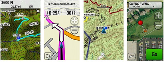
There are plenty of high-quality, free 1:24,000 scale topo maps available at GPS File Depot, along with some very good instructions onhow to install them. A sample screenshot is shown below, at left.
Garmin BirdsEye Topo US and Canada
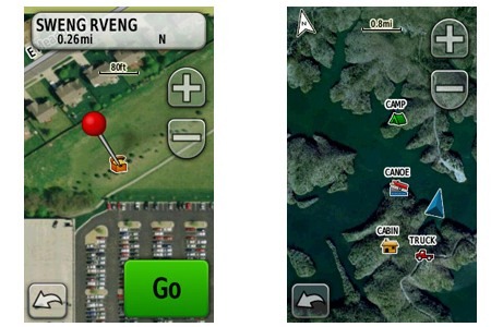
Want USGS style topos on your Garmin? Then BirdsEye Topo (shown above at right) is for you. It offers an all you can download subscription plan for $29.99 per year, but if you’re smart about it, you can download whatever you want the first year and not have to pony up again unless you upgrade to a new GPS. Available direct from Garmin.
Tech talk: Raster vs vector
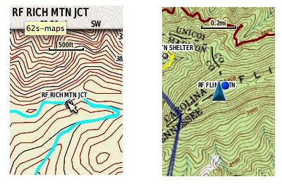
Before we go any further, I should explain the difference in these two types of maps. Vector maps, like the ones from GPS File Depot and Garmin’s new 24K series (discussed below), are made up of data, which show up on your screen as lines and points. Because the files are data, they take up very little memory. They also have an advantage in that you can zoom in and out very far without any blurring.
Raster maps, on the other hand, are made up of images. Examples include Garmin BirdsEye Topo and BirdsEye Satellite Imagery. Since they are image files, they take up a lot more memory. They are also limited by the fact that you can only zoom in or out so far before the image becomes fuzzy.
In the images above, a vector map example is show at left and a raster map on the right.
Topos and Roads: Garmin 24K series
Want the best of both worlds? Garmin’s new 24K topo series offers detailed topographic maps along with routable roads and trails. Highway and points of interest coverage seems to be nearly identical to the City Navigator maps found in their Garmin nuvi products.
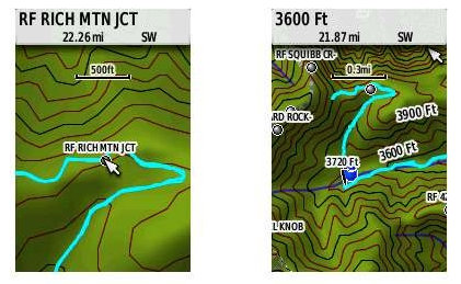
Routable roads allow you to use a compatible handheld GPS to navigate to a trailhead waypoint, making this one of my favorite map products. Another advantage is that these maps come with a digital elevation model, giving you shaded relief (although the darker images can reduce visibility on touchscreen models such as the Oregon series). These are available direct from Garmin, and various online merchants, such as Amazon
, REI
and GPS City. Screenshots below…
Why you should avoid the “t” models with preloaded topos
The “t” model Garmins, like the Oregon 450t come with preloaded 1:100,000 scale topos. I say don’t buy them, going for a version with just a basemap instead. First of all, you can get better quality 1:24,000 scale maps for free (see above). Second, the 100,000 scale roads appears to be based on TIGER data, which is notorious for misplacing roads a hundred feet or so. The primary reason to buy one of these units is if you travel the country extensively and don’t have time to load 24K scale maps. Just know what you’re getting.
 Highway maps only
City Navigator
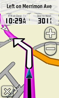
Urban cacher? Want pure highway maps? Garmin City Navigator (shown at right) is the way to go, with options as low as $59.99. Just make sure you have a compatible device capable of turn-by-turn routing. Touch screen units work best for this, and it’s ideal to have a mount and a power cord for your car.
OSM: The free option
Open Street Maps produces crowdsourced maps that can be downloaded for free from sites like garmin.openstreetmap.nl and downloads.cloudmade.com. You will get a similar map to the one shown at the right, although road and points of interest coverage probably won’t be as good as with purchased Garmin products.
Aerial imagery
For urban explorers and folks living in the open landscapes of the American West, Garmin’s BirdsEye Satellite Imagery (shown below) can make a big difference. Just like BirdsEye Topo, the price of admission is $29.99 per year, and while you can still access it once the year is up, with aerial imagery changing all the time it may be worth keeping a current subscription. Available direct from Garmin.
International options
I won’t go into detail about them here, but I have written a couple of posts on this subject before:
Related post
Other questions?
Did I miss anything?


Each map source has its pros and cons and you will likely have to use different sources for different trips and possibly multiple sources for a single adventure. New roads, parks, and trails are constantly being created while older roads and trails are rerouted due to overuse. Sometimes the most informative map of an area is a not-to-scale sketch map by a local authority. Though you can load these into a Garmin GPSr with the Custom Map feature, they won’t be any good there since the features are simplified for clarity and not drawn to scale. Thus, even though I have several paid and free electronic map sources installed on my GPSr, I often find myself exploring a new park with only a park brochure and a trail-less USGS topo to guide me. When this happens, I make sure to collect clean GPS tracks and add as much as I can (sometimes a whole park) to OpenStreetMap and Google Map Maker so others (including my future self) will have the convenience of an electronic source.
On the subject of paper maps, I don’t consider my GPSr to be infallible, and always carry a backup paper map, whether it’s a 24k topo from the National Forestry Service, a 63k NatGeo Trails Illustrated, or just a printout of the best electronic map of the area from Garmin’s BaseCamp software. I’m also never without a plain old magnetic compass.
As far as the electronic map sources go, though, Garmin’s 24k tends to have the best coverage of National Parks in my area (NC), but is lacking trails in state parks and smaller. OpenStreetMap has most all of these in my area, but lacks the elevation data. As such, I keep both Garmin’s 24k and OSM on my GPS receivers. I download fresh (routable) OSM archives every month or so to reflect new changes and contributions.
I happen to find researching maps to be fun. Not as much fun as actually go out in the woods, but still fun. Others might prefer more of a “set it and forget it” solution, but that is difficult to find for many areas and activities.
First let me say, after using my Garmin GPSmap76S for 8 years, I broke down and bought the Montana 650t. I am very pleased with the strong satellite reception and the entire GPS. I did not read your advice about not purchasing the “t” series before buying the unit. My questions: Can you load the 24k topo program, the city navigator and the Aerial imagery all into one unit or would that be too much. I am a farm, ranch and recreational land real estate agent and use my device extensively. I also geocache quite a bit and use my GPS in the outdoors for recreation. Having all in one unit would certainly be great. By the way, I started geocaching just to learn how to use my GPS better. It worked and I fell in love with it. Thanks for your time
Sure, as long as there is enough memory or you add a microSD card. It depends on how large of an area you are trying to cover. This might also prove helpful: http://gpstracklog.com/2011/09/on-the-road-with-the-garmin-montana.html
Glad you’re enjoying the Montana!
Thanks for the info. Montana is great. It locks on to satellites extremely fast and accuracy is phenomenal even in dense foliage. Much better than the old map76S. I still carry it out of “I don’t really know”, I guess I’ll ust have to ween myself. Thanks for a great publication.
Quick question I can’t seem to find an answer for. I’ve formatted an sd card for my new eTrex 20. Now do I need to create special folders for geochaches, custom maps, etc?
Yes, create a Garmin folder for regular .img maps. Inside the Garmin folder create a GPS folder for geocaches and a CustomMaps folder for any true custom maps.
Thanks! I got my replacement from Amazon and am headed to York, Me for the weekend. Got some topo maps and geocaches loaded and ready to go!
“What kind of maps do I need for my Garmin handheld?”, really closed the loop for me. I’ve had the Garmin TOPO 24K maps and just subscribed to the Birdseye TOPO and really enjoy having the best of both worlds in my Montana 650. Per your past writing on the subject I purchased the Montana 650 without the t earlier in the year when EMS had a great sale on Garmin. I like the extra information on the USGS maps in combination with the Garmin TOPO. What a treat.
I was wondering if you would consider doing a sort of comparison chart for Garmin maps. I hate to say it but all the different offerings are kind of overwhelming to me. What I think would be helpful would be a side by side comparison of the different formats and what you can and can’t do with each one. For example, you can use preloaded SD cards in any device, but not DVD or Downloads. Some can be stored and viewed in Basecamp, but some need the host device connected. Some can be backed up to your hard drive, some can’t. Birdseye Topos can be saved for use after subscription lapses. Some maps have POIs and routable roads, some don’t. Some can be updated, some just have to be replaced with new, etc, etc. Whew, sounds like a lot of work! Anything like that a possibility in the future? Thanks for all your great info and time!
I’ll put it on the long list of possible things to do. 🙂
It sounds like you actually have a pretty good handle on the differences, but I could see how this would be helpful to others. Are there any specific things that you have questions about?
Well, I’m thinking of getting the 24K topo series and subscribing to the Birdseye topos as well. Do any formats of the 24K topos allow for updates? And are the Birdseye topos something that could be printed out as a hard copy? Thanks for the info and I’m looking forward to that chart!! 😉
I don’t believe there is anyway to update the 24K maps. But yes, you can print BirdsEye topos. Hope that helps!
Rich, I just received my new montana 600 and would like your advice on the type of map I should purchase for “paved backroading” through the North East, in a sports car. (Gave up my bike…Getting too old; But still love winding roads.) Have a Great Day… T
The Garmin 24K topo includes City Navigator roads, but if you want voice prompts, you’ll need the non-topo City Navigator, and a special mount… http://gpstracklog.com/2011/09/on-the-road-with-the-garmin-montana.html
Thank you Rich, for your fast reply. I guess all I really want, is a map, with the ability to apply way points to a given location. I’ve looked into the Garmin ” birds eye” and will probably go with that. I would never “dash mount it”. Thank you and have a great day..T
I received a 450 for Christmas and am just getting into it. There are several pre-loaded maps but I can’t find any information on them or which one is being used. This statement is from the Garmin site about the 450:
“Oregon 450 comes with a built-in worldwide basemap with shaded contours. Simply touch the color screen to navigate. Its digital elevation maps show you shaded contours at higher zoom levels, giving you a big picture of the surrounding terrain.”
I don’t see and shaded contours only a road when I zoom in. I want to use this mainly for hiking and know I need to download topo’s but are the pre-loaded maps any good or should I delete them for space? Also, how do I select the map I want to view?
Also while checking it out I creacted a waypoint of my current position. When I zoomed in it had a black line scribbled all around it, like tracking was turned on but I didn’t turn it on, or don’t think I did. Do you think that’s what it was?
Thanks!
The basemap is pretty worthless although it will give you shaded relief when combined with other maps. It doesn’t take that much space so I would not delete it.
Assuming you’re in the US, there are good free topo maps available at http://gpsfiledepot.com.You can enable and disable maps under Setup > Map > Map Information.
Tracking is enabled by default.
Hope this helps.
Hi,
We downloaded the birdseye and downloaded the map area onto the Garmin 600t Montana. We cannot open the map. Could you tell me how to do this. It is in our maps on the handheld unit.
Thanks,
I want to use my Garmin 10 for geocaching, but can’t figure out how to get maps downloaded and which maps to use. Can anyone help?
Rich,
I have an Oregon 650 and have been trying to find some topo maps for Arkansas. There are a few on gpsfiledepot but not exactly what I am looking for. Most of them I have found only have part of the state and while I can use that I also need the other part. So I have looked at the Garmin 24K maps or even bridseye topo and a seemingly new product Hunt by onXmaps. Do you know anything about onXmaps products? They look good and interface with Garmin and basecamp. I would love for you to do a review on the Hunt by onXmaps. Your reviews and other information have been so very helpful.
Thanks,
Tom
Forgot to include the link.
http://www.huntinggpsmaps.com
I am using Garmin GPSMap 62 for Geocaching and what I love is that I can import the paper tourist maps (we have plenty of them with high details) and then go according to them – I am using this way: https://www.youtube.com/watch?v=w86HWsCxGyM . The areas that can be imported are much bigger then of the images created in the Google Earth.
I have the TOPO 24k map on my laptop. I have an Oregon 600t and can’t download the 600t waypoints onto the TOPO map. Can i download the new Garmin 24k topo map on both my laptop and the 600t? If so would I then be able to move waypoints between the two?
I am wondering whether there are any written instructions for using the Garmin 24K Topo map downloads on a handheld. I have the eTrex 20x and I have no idea how to input a park name as a destination. The software allows one to input theme parks (for example) but not parks. Anybody got an idea?
I’m a 63 year old lady and I lead a walking group twice a month by reading the instructions of a walk or by map alone. We usual walk on footpaths and only walk for two – three hours. I find I don’t enjoy the walk as much as the other ladies who rely on me not to get them lost, as I am always referring to the map. I’ve been looking at the Oregon 600 or 650. I’ve been to a couple of retailers which wasn’t helpful as they just referred to your online spec. 1st question: if I didn’t want a camera on my GPS should I still go for the bigger memory so I can keep my personalized walks on the GPS? 2nd Q: Which map will I need TOPO, 1:25k or 1:50k? 3rd: Can I plug in the GPS to the computer so I can plan a walk?
Excellent site you’ve got here.. It’s hard to find high quality writing like yours nowadays.
I honestly appreciate people like you! Take care!!
Please let me know if you’re looking for a author for
your blog. You have some really reat posts and I feeel I would be a good asset.
If yyou ever want to take some of the load off, I’d love to write some content for your blog in exchange for a link back to mine.
Please shoot me an email if interested. Regards!
Nice Post, thanks!
I have a new Garmin 62s and would like detailed USGS detail to show me old logging roads. What do you recommend?