I’ve accumulated quite a few Garmin map downloads over the last few years. Some, like City Navigator or Rails to Trails maps, can be downloaded for a year from the purchase date. Others, like BirdsEye imagery, are offered as an annual subscription. Many of us were reassured about the latter when Garmin told us that “imagery downloaded to your device or a micro-SD card does not expire if your subscription lapses.” Ah, but the devil is in the details.
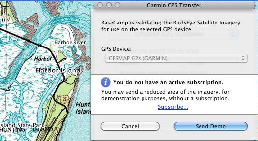
It’s true that you can keep using imagery or maps already on your device. But it turns out that once your subscription expires, you can no longer transfer those files from BaseCamp to your unit. Fortunately for you, we’ve got a work-around…
The trick is to back up those files to your computer. Just download all the imagery and/or maps to your device or microSD card and then copy them to your hard drive. I’d encourage you to do this for BirdsEye satellite imagery, BirdsEye Topo, Rails to Trails maps, City Navigator maps that you may have bought for your handheld, and any other Garmin map downloads. Remember, these maps are still locked to a single device, but this will give you the ability to manage the device memory and move things back and forth. Here’s my current Garmin backup folder…
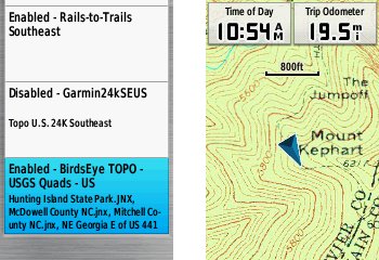
My BirdsEye Topo subscription expired on May 29 and I’ve since verified that I was able to send those maps back to my 62s, as shown below.
Special thanks to Boyd for his tips.


I want to see a demo or some actual birds eye view screen shots, where can I find them?
Here’s what Garmin says, but I couldn’t get it to work on my Mac yesterday.
First and foremost, thank you for the great site, it has been the most helpful and informative resource in my quest to pick my first GPS. I ended up with the Oregon 450T for $249.95 on sale at Cabellas’ today after a week of comparing and am confident I made the right choice. Confused & overwhelmed by the lack of clear instruction with regard to software & maps but the device itself is solid and intuitive. I went ahead and purchased the Birds Eye Topo,s & Sat imaging when I got home figuring it ‘s the best value for some one getting started. I just ran across this thread seeking more info and want to make sure I have the work around correct…
When backing up the Topo/Sat files just copy them into a folder from the SD card in an Explorer window and copy them back when needed(copy &paste)? Externally from Base Camp?
Do you think it’s possible to make multiple SD cards with downloads on them and switch them as needed?
I thought I read somewhere amongst the hundreds of threads I’ve been through that for performance reasons I shouldn’t use a SD bigger than 4 gigs in the Garmins???
Being as I’m mostly interested in the West Coast States would just buying the DVD of the 24k’s have been a better option?
There are so many good and bad reviews on every product associated with all GPS’s and accessories it’s just mind numbing.
Any help or direction would be greatly appreciated as to where to find good set up advice for a new like myself.
Thanks,
John
Yes, that is how you back them up. They should have .jnx file extensions.
Switching microSD cards is a pain and I definitely wouldn’t try to do it in the field! You can fit a lot on one card. But yes, it is possible.
You can use up to 16GB, maybe 32GB. See H4 here… http://garminoregon.wikispaces.com/Hardware
The 24K Garmin maps are nice because they have routable roads, but there are plenty of free 24K topos (without routable roads) available at http://gpsfiledepot.com
Thanks Rich,
I hadn’t stumbled into the Oregon wiki yet. I see myself spending quite a bit of time there…
Is it possible to back up and remove the 100k map the same way?? Or should I leave what came on the device alone(for risk of bricking this thing). I ask this because I downloaded the two counties I spend the most of my time in from Birdseye Topo, the down load was like 860ish ?? Mb, but it won’t fit on the space left because it seems to expand when transferring to the device and ended up being over a gig. I’m pretty disappointed with the 100k maps but expected as much which is why I originally planed on acquiring the 450(not 450t) but as it turns out because of a sale it was cheaper. My intended uses for the GPS are hiking trails and navigating wilderness (and eventually geocaching) so the 24k maps seem better to me.
Iv’e so far found posts that state I can remove the 100k but details are are a little sketchy as to exactly how and how to restore it (if it was ever necessary)… I should probably just forget about the extra memory but I know it’s there and my sd cards are in the mail.
You *should* be able to by removing the [drive]:\Garmin\gmapprom.img file, but I would back up the entire unit to a computer first. There are a couple reasons to keep them though. If you ever travel on short notice, you’ll at least have 100K maps. Also, by leaving the 100K basemap there, you’ll have shaded relief available for any 24K maps you install.
That Sounds like the most logical thing to do(leaving it that is)… there’s only <3 gigs of memory to gain. I must say I'm glad I got the down load subscriptions. Those combined with the gpsdepot and OSM streets are all I'll ever need for this thing.
Thanks again and Happy Holidays to you.
Hi Rich, I was wondering if this site and your help is still active. I have read many helpful things here and have questions of my own.
Hello,
62 year old Michigan / Vermont Ruffed Grouse hunter and former forester, surveyor and military / Coast Guard pilot – so I am quite familiar with various forms of geo-referencing, charts, maps, navigation. Since the early 1970s, for hiking and hunting I have been partial to using the ol’ 1 :24K folded quadrangles, a Silva, a stubby pencil and the sun to complete my “A to B to C to D etc. and return “hunt plans”. I would like to more accurately execute these planned maneuvers, moreover, know exactly where I have actually traveled. So, I am looking for a / the very best 1:24K display (not necessarily large, but sharp detail) that provides a “dotted trail” or some reference to exactly where I traveled. Can you recommend the best handheld GPS that provides such?? I am also partial to using Lat / Long in the degrees, minutes, decimal minutes format as my primary geo-reference. Thanks!