This week in GPS is a weekly link roundup of (mostly) GPS related odds and ends, from GPS Tracklog and other places around the Web. To get a few of the biggest stories as they break, follow me on Twitter. Our lead video is a celebration of two million geocaches, a milestone due to be passed this coming week (via Not About the Numbers).
From GPS Tracklog
Our posts from the past week:
- New TomTom RIDER for motorcycles
- Logging Caches With GSAK’s ‘Geocaching.com Access’ Feature
- Garmin nuvi 52LM review
- TomTom for Android (brief) review
- I’ve also posted a new GPS deal this week on the Garmin nuvi 3490LMT
Driving recorders, asteroids and meteors, oh my
- I’m not sure how many of you caught videos from driving recorders capturing a meteorite yesterday, but I felt compelled to share the video above on why there are so many Russian dash cams (via @mcwetboy)
- Reconstructing the Chelyabinsk meteor’s path, with Google Earth, YouTube and high-school math
- USA Today erroneously reports that asteroid 2012 DA14 came closer to Earth than GPS satellites
Garmin
- A transatlantic nuvi with voice command; Thanks Dick!
- Thieves steal Garmin team’s bikes so they train instead of racing
- Garmin launches short film adventure series to promote the fenix
- In marine news – New glass helm GPSMAP series; Panbo’s take
- GB BikeHike map for your Garmin GPS (here’s a BaseCamp version)
- Greece and Cyprus Garmin Compatible Map
Geocaching
- Getting started geocaching; via Geocaching Journal
- Geocaching Tips: How to get a FTF
- Was a geocache mistaken for a bomb or did someone lose their GPS?
- Geocaching Art
- Travel Bug Races; via GeoGearHeads
- Geocaching version 5.1 for iOS
- Geocaching Love Stories
GPS in the news
- Arsonist’s GPS rats him out
- Urban GPS Navigation Improved 50-90 Percent; implications for connected vehicles and autonomy
- Researchers See Ionospheric Signature of North Korean Nuclear Test
- Product Defeats the Threat of GPS-Spoof Attacks on Financial Trading Firms
- How to Use GPS to Make a Valentine:
A GPS valentine
Satellites and such
- Brief primer on the Next Generation of GPS Signals
- Test Confirms EGNOS + Galileo = Safer Skies
GPS tracking
- Cool science project using SPOT: Hello Kitty in Outer Space (see video above)
- Police: GPS tool will make chases safer
- ACR ResQlink 406 Personal Locator Beacon Review
- 11 defendants on GPS monitoring charged with violent crimes in past year in D.C.
- Some may just be too dumb to know what a GPS tracking device is
- Spot relaunches social media platform
- World’s rarest antelope GPS collared for first time:
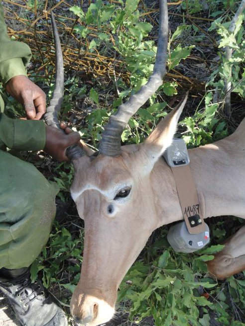
Ever wonder what a wildlife tracking GPS collar looks like?
The business of GPS

What a TomTom/TeleAtlas mapping van looks like
- GPS Fitness Watch Market to Grow 50% in 2013
- Facebook to focus on fitness in 2013
- Trademark on “Geocode” Prompts Removal of Term at OpenStreetMap Wiki
- New GPS lobbying group: GPS Innovation Alliance
- TomTom fourth quarter and full year results
- Reaction from Bloomberg and GPS Business News
- Welcome to the mapping business! Apple Maps Blamed For Inaccuracies In Australian FireReady Bushfire App; here are some quotes:
The FireReady app was forced to use Apple Maps, CFA said, but the maps were inaccurate and “Macedon and a number of other Victorian towns are located incorrectly”…Users report that towns are located on their maps at the centre of the district rather than on the actual township itself…This makes it very difficult to quickly determine the exact location of fires once alarm calls are being received.
Updates
- Software updates this week: Garmin dezl 760, Magellan eXplorist GC, Magellan Switch series
- Magellan Active API v 1.5
- Magellan Active Website v 1.6
Just geo
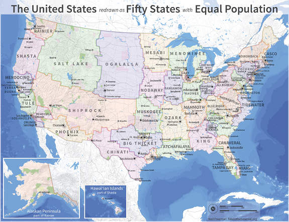
A better electoral map?
- If our 50 states had equal population (see image above); via Jonathan Crowe
- 19 Maps That Will Help You Put The United States In Perspective
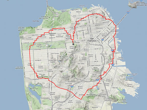
- Know your city’s neighborhoods (or create a map of them); via All Points Blog
- A map showing pollution caused by ships; via @maproomblog
- Put Tibet back on the map
- Building by building extent of Hurricane Sandy flooding; via @GPSGIS_Eric
- Were a wealthy married couple murdered after Google maps led hitman to the wrong address?
- Checkerboarding (an all too common western US land ownership pattern):
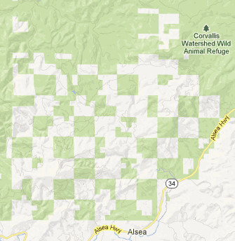
Checkerboard BLM lands
All the news that doesn’t fit
- GPS receivers interfere with avalanche beacons in search mode
- State Laws Could Ground Even Hobbyist Drones
- Cool Magellan contest
- More info on the BluTracker
Updated GPS reviews
I’ve updated these review and resource pages with the following links:
- Garmin Edge 800 – My Orange Brompton reviews this GPS cyclometer
