
Hands on with the Garmin GPSMAP 547xs
The Garmin GPSMAP 547xs is an all new marine chartplotter recently introduced by Garmin. The GPSMAP 547xs has a 5″ diagonal color screen and an all new look from Garmin. The traditional silver bars at the top and bottom of the case have been removed for a very stylish all black trim ring. The major upgrade over the previous generation is wireless capability (WiFi and Bluetooth) and the sounder module was upgraded to include CHIRP technology.
The GPSMAP 547xs comes pre-loaded with United States Coastal Charts and also has dual MicroSD card slot for additional charts. A MicroSD card with Inland Lakes is included in the box which gives enhanced details. The dual MicroSD card slots are used for adding enhanced charts and for transferring waypoints, routes and tracks.
Related Models
- Drop down to the 527xs for wordwide basemap only
- Drop down to the GPSMAP 547 to remove the sounder module
- Drop down to the Echomap 50s and you lose NMEA 2000, CHIRP Sounder (it has Echo HD-ID sounder), and 3D Chart views
- Move up to the GPSMAP 741xs to get a touch screen interface and a larger 7″ diagonal landscape display with higher resolution; the 741xs relies on its touch screen alone and drops all hardware buttons
Garmin GPSMAP 547xs Display
The display is a 5″ diagonal, with 480 x 640 pixel resolution. The display was extremely bright and easy to read in direct sunlight and while shaded. The display is also very bright and easy to read when viewed straight on with polarized sunglasses, but goes almost entirely black when viewed at an angle with polarized sunglasses. The resolution is good for the screen size and all the chart items are clear to read. Garmin has added a feature that automatically adjusts screen brightness to the ambient light. The automatic adjustment seemed to have a very broad range, and it was surprisingly much better then I had anticipated. Even late at night, the display went all the way down to a very comfortable brightness level.
Garmin GPSMAP 547xs Interface
If you have used any of the more recent devices from the higher end of Garmin’s Marine line, the interface and menu structure will be very familiar. While it seems that the interface was designed for a touch screen, it is also very simple to navigate with the arrow keys. All the screens and information are very well laid out and the menu structure is intuitive.
Pressing the Home button takes you to a main menu where you can choose the major functions of the GPSMAP 547xs. From here you can choose Chart, Sonar or a combination. Other options may show up on the home screen if you have accessories attached such as XM weather or Engine Gauges. From the home screen you can drill down to the specific function that you require. After you choose Chart for example, then you can choose a conventional top down chart or a 3D chart view.

Garmin GPSMAP 547xs menu structure
The Home menu can be customized by adding some of your favorite screens and reorganizing the order. This will help alleviate drilling down through the menus to find your favorite screen. You can not delete any of the default choices from the menu that were included by Garmin.
Wireless Connectivity
 The newly added feature that excited me the most about the GPSMAP 547xs was the wireless connectivity. I already had Garmin BlueChart Mobile installed on both my iPhone and iPad. It was very simple to use the GPSMAP 547xs to create a wifi network and connect my iOS devices to that network. Please be advised, while the iOS device is connected to the boat’s wifi you are not able to connect the iOS device to the Internet via wifi at the same time, but you can connect your iOS device to cellular Internet.
Garmin BlueChart Mobile allows you to easily create waypoints and routes on your iOS device. The touch screen of the iOS device makes it very simple to place waypoints, and legs of a route. After I had a few waypoints and routes created, it was extremely simple to transfer the waypoints and routes from iOS to the GPSMAP 547xs. It was also very simple to transfer any waypoints and routes back from the GPSMAP 547xs to the iOS device. The only part that disappointed me was that you apparently can not transfer tracklogs from the GPSMAP 547xs to BlueChart Mobile. At the end of every season, I like to transfer all the tracklogs from my plotter and file them away. It’s permanent record everywhere the boat has been all season. It was disappointing to me to see that feature lacking from this setup, with every other part of it being so simple and effective.
UPDATE: It turns out that you can transfer tracklogs from the GPSMAP 547xs into BlueChart Mobile. Using the GPSMAP 547xs, you must first save the tracks. After they are saved with an appropriate name, they can be transferred.
The GPSMAP 547xs also allows Bluetooth Connection to audio devices such as smart phones and digital music players. Currently the only profile that is supported is AVRCP. That means you can use the GPSMAP 547xs to see what song is currently playing, play, pause, and advance to the next track.
NMEA 2000 Connectivity
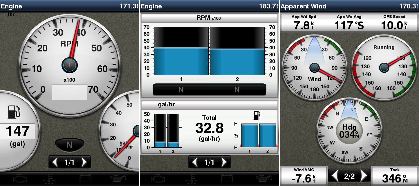
Using NMEA 2000, I was able to quickly interface the GPSMAP 547xs into my NMEA 2000 network. The GPSMAP 547xs immediately identified my two Garmin GMI 10’s and also my Volvo EVC-D engines. This allowed the GPSMAP 547xs to report GPS speed to the Volvo EVC-D display and also allowed the Volvo hardware to report fuel flow and all engine data back to the GPSMAP 547xs. (Note: the internal GPS antenna in the GPSMAP 547xs was the only GPS sensor on the NMEA 2000 network during the testing.) Both the Volvo engine display and the GPSMAP 547xs were able to show fuel efficiency (nmpg/mpg) based on information provided from the other. GPS speed, RPM, engine temp, oil pressure, volts, fuel level, fuel flow, and lots of other information was flowing back and forth. If you know how to plug in a USB mouse into your computer, that’s about how easy it is to plug the GPSMAP 547xs into an existing NMEA 2000 network. Creating a new NMEA 2000 network is just a bit more complicated, but it is something that can be handled by an amateur installer.
While NMEA 2000 is industry standard, apparently there are few manufacturers that have some different ideas how things should work. I happen to have a NMEA 2000 Bennett trim tab level indicator kit on the network (the NMEA 2000 interface was apparently manufactured for Bennett by Lowrance). The GPSMAP 547xs would not indicate the trim tab position (neither will my Garmin GMI 10‘s). Apparently the only way to get the trim tab position to show up on the Garmin Displays is to use the Garmin GBT-10.
The back of the GPSMAP 547xs also has a RJ-45 Ethernet port. There is no mention of this port in the manual or how to use it. Garmin must be planning something in future with a firmware update? It will be interesting to see if this port is ever used and how it is used. With the current firmware, the GPSMAP 547xs will not interface with the Garmin Marine Network.
Preloaded Charts
The GPSMAP 547xs includes preloaded charts of the U.S. Coastal waters in internal memory. A MicroSD card with inland lake charts was also included in the box. The charts in internal memory allow a Perspective 3D view that includes the same bottom soundings and land masses that are on the normal 2D chart view. Additional charts can be purchased and loaded using the dual MicroSD card slots on the front side.
The pre-loaded charts are very easy to read and have great detail of the entire U.S. Coastal area, including the Great Lakes. Keep in mind these charts are U.S. waters only. They do not include charts of our nearest neighbors such as Canada or the Bahamas.
UPDATE: Charts of the Bahamas are included in the pre-loaded charts.
The spot soundings are easy to read and very clear. The shoreline detail and land masses are clearly marked and labeled. All Navaids are simple to identify. The complaint that I had with chart clutter on the GPSMAP 541s is still present on the GPSMAP 547xs. It is very difficult for the algorithm in the plotter to decide how much information should be displayed on a chart. Too much data, and everything is jumbled together in a big mess. Too little information, and you may miss important features. The GPSMAP 547xs allows you to increase or decrease the chart clutter under the chart setup menu. For all screen captures, I had Chart Detail set to Normal. I had a situation where I was navigating across Lake Erie in a very familiar area. There was a shoal ahead that I knew was there. At the particular zoom level that I had chosen, the shoal was not indicated on the chart. Note the two screen captures below:
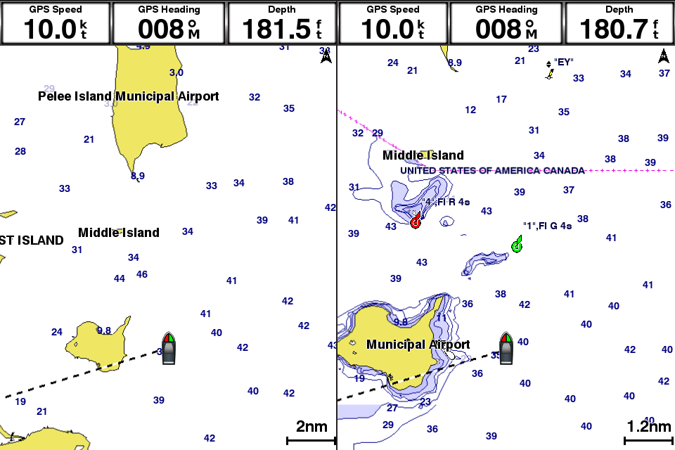
These screen captures are only one zoom level apart. At the 2nm chart scale, there nothing but empty white space where the shoal is located just to the north of my position. Bump the zoom one level to the 1.2nm scale and the shoal becomes apparent on the chart along with a navaid that helps indicate the shoal position. I wish the navaid would have showed up on the 2nm scale chart in the empty space. Or it might be nice if the clutter algorithm that is used, indicates the most shallow depth sounding in the area on the 2nm scale chart. Either option would at least get your attention that something significant might be there, and would prompt you to zoom in to investigate. At the 2nm scale, the chart is definitely not too cluttered to indicate the shoal. Notice at the 2nm scale, there are no depth contours on the island just to the East of my position. On the 1.2nm scale, the depth contours and bottom shading become evident. That is a visual cue that important data is missing. Increasing the Chart Detail in the chart setup did make the shoal appear at the 2nm chart scale. It might just take a little practice in a familiar area, to familiarize yourself with the level of detail you would like to display. This example also illustrates why mariners should also reference paper charts. Sometimes a 5” window into the world is simply not large enough.
If you load an optional MicroSD card with Garmin’s Bluechart G2 Vision charts, then the 3D MarinersView and 3D Fishview become available in the menus. The Marinersview and Fishview attempt to draw a 3d representation of the bottom contours similar to a bathymetric chart and they use some different colors to represent danger areas on the chart. You can adjust the safety depth as it applies to your own vessel. The colors displayed on the chart will also adjust so that safe water is easily identifiable.
The charts can also be split with other chart views. The last screen shot below shows a large scale navigational chart and also a real time NEXRAD weather map overlay on top of a small scale map. The NEXRAD weather map requires one of the optional weather attachments along with subscription to the service.

Navigation
Once a recreational boater gets their GPS programed with waypoints and routes, many boaters are comfortable with the highway screen as a graphical means to following those waypoints and routes. Garmin seems to have dropped that highway screen nomenclature from the menu structure, even though that same GUI concept is alive and well. The screen that is the most similar to the highway screen is now under the Chart menu and it is called Perspective 3D. This screen now includes chart data.
Waypoints and Routes are easily found using the Nav Info menu item from the Home Screen. The Waypoints menu shows a list of all waypoints starting with the nearest, ending with the furthest. You can scroll through a large list of the waypoints faster using the +/- buttons to page your way through the list. In addition to Waypoints, Routes and Tracks, the Search by Name menu also includes Offshore Services. This is POI data that allows you to search for various service that you may require on the water, services such as Fuel, Repairs, Grocery, Restrooms, Boat Ramps, Marinas, etc. The data is pulled from the pre-loaded Bluecharts or from data that is contained on a optional chart card.
Keep in mind that if you navigate to any of the POI or waypoints, that the GPSMAP 547xs will take you on a straight line to that point. That straight line may take you over dangerous water or even over land. If you choose a point from the POI database, the GPSMAP 547xs will show you the chart screen with the position of the POI that you selected. It will then ask you to enter additional Turns to get to that point. It’s very simple to add waypoints to plot out a safe route through safe water using the pre-loaded charts. However, this is not something that the GPSMAP 547xs calculates automatically.
UPDATE: If you have a BlueChart Vision card, the GPSMAP 547xs will do auto guidance. If you select a Waypoint or POI, you can have the GPSMAP 547xs automatically calculate a safe route through sufficiently deep water to that point. You should configure the Auto Guidance Safety Depth in settings menu, before you use this feature. This functionality only works if a BlueChart Vision card is inserted.
Sounder
Be advised that Garmin has recently had a change to their cabling. The new transducers come with an 8 pin wire harness, which fits perfectly into the GPSMAP 547xs. Many older transducers use a 6 pin wire harness that will not plug into the GPSMAP 547xs. I had some trials and tribulations getting my old 6-pin transducer to work with the GPSMAP 547xs, but I did get it to work finally. Garmin offers an 8-pin to 6-pin adapter cable (010-11612-00) for about $16 that will not work! It goes the other way. It will adapt an 8-pin transducer to a 6-pin sounder. Garmin also offers an 8-pin wire block adapter (010-11613-00) that runs $69.99. This is the adapter required to use the GPSMAP 547xs with a 6-pin transducer. You need to cut the 6-pin connection from the end of the existing transducer wire, strip back the insulation, and then attach each of the wires to the terminal block inside the 8-pin wire block adapter. Here is where another wrinkle suddenly came up. After I connected the wires per the included instructions, the transducer did not work. I fired off an email to Garmin Support. The next day, I received a response that the instructions included with the wire block adapter were incorrect. Attached to the email were the correct instructions. After making the corrections to the wiring, the transducer and sounder worked together flawlessly.

All my testing was completed with my existing thru hull Airmar B60 transducer. Unfortunately I was not able to test any of the new CHIRP capabilities since I was lacking a CHIRP transducer. The sounder was able to see the fish and also determine the approximate bottom composition. The sounder was able to maintain bottom lock all the way up to the maximum speed of my boat at 52mph. The sounder has many different options for zooming, gain, and varying frequencies. That should give any angler a great advantage over the fish. One new feature of the 547xs is Sonar Recording to the SD card. The sounder screen is also able to be customized to show other information including a compass tape with CDI. So you can monitor the fishfinder while navigating to a Waypoint.
Mounting
The GPSMAP 547xs offers a few different options for mounting to your boat. Included with the unit is a mounting bracket that can be affixed just about anywhere. The mounting bracket allows for full articulation left right up and down. The bracket has a disc shaped base that attaches with three screws. I wish the left to right pivot adjustment grabbed a little bit better. After tightening the thumb screw as tight as I could get it, the GPSMAP 547xs could still swing left and right a little to easily for my tastes.
Another alternative is surface mounting the GPSMAP 547xs. There is a trim ring that pops off the front and exposes mounting holes. The GPSMAP 547xs can be attached from the front which is so much more simple then many of Garmin’s previous surface mounting methods. One small complaint is the cutting template has some gentle curves to match the curves of the back of the GPSMAP 547. It would be so much more simple to cut the hole if the template had straight lines on all four sides.
An optional flush mount kit is also available from Garmin. This will result in the front edge of the GPSMAP 547xs being completely flush with the rest of the helm. It’s an extremely finished look that I am sure many OEM boat builders will use with this model.
Garmin GPSMAP 547xs pros
- WiFi connection to BlueChart Mobile
- Ease of use, simple menu navigation
- Very bright screen
- Pre-loaded U.S. coastal charts
- Included inland lakes charts MicroSD card
- Built-in sounder module
- NMEA 0183 & NMEA 2000 connectivity
Garmin GPSMAP 547xs cons
- Screen goes black at extreme angles with polarized sunglasses
Can’t transfer tracklogs to Garmin BlueChart Mobile- Incompatible out of the box with older transducers
- Incompatible with Garmin Marine Network
Garmin GPSMAP 541s conclusion and recommendation
This is a very nice fixed mount chart plotter that has great features and also many good qualities. I can recommend this unit to any recreation boater or fishermen.
More Garmin GPSMAP 547xs reviews
It looks like we’re the first to review the 547xs, but we’ll try to update this with links to other reviews as they appear online.
Other Garmin GPSMAP 547xs resources
- A set of 547xs FAQs
- The official Garmin GPSMAP 547xs
web page
Compare prices on the Garmin GPSMAP 547xs at these merchants:
- Check the current Garmin GPSMAP 547xs 10Hz GPS/GLONASS Receiver with Transducer
price at Amazon
- Get the Garmin GPSMAP 547xs at GPS City
- Buy the Garmin GPSMAP 547xs

Great review on the Garmin GPSMAP 547xs. I am in the market and have been looking at this chartplotter. Thanks for taking the time to share the information. As for the screen blacking out at an angle with wearing polarized sunglasses, I think that will happen with most screens, just my opinion
Excellent review. Good information on connectivity and tips how to operate safely. A lot of good details that I wouldn’t have seen on Garmin’s site.
Thanks!
Great review, good to read information about real world use, not just marketing info.
What transom transducer (CHIRP) would you recommend for the Garmin GPSMAP 547xs and what is the cost. Thanks
I have not tested any CHIRP transducers, so I can’t recommend any one in particular. Mounting method, (ie: in-hull, thru-hull, transom mount, etc) and the depth where you are using your transducer will largely influence the best model for you. You might want to review this guide:
http://www8.garmin.com/transducers/d/Garmin-Transducer-Selection-Guide.pdf
CHIRP transducers are definitely more costly then others.
I have this plotter and a BlueChart Vision card. Do I still have to buy the map for my iphone as well? I would have thought that while connected via wifi to the plotter that it would have recognized the card and enabled the mapping on the phone. Maybe I am just dreaming?? This will get further testing this weekend on our Labor Day weekend trip so maybe something will change. I was thinking that the phone would duplicate what was on the screen of the plotter but I have not seen that happen yet.
Sorry to ask this here but I have not seen the answer any place on the Garmin site. Thanks.
You will need to purchase the charts in the BCM app, to see the charts on your iOS device. The good news: if you have multiple iOS devices (iPhone, iPad, iPad mini, etc), you only have to buy the charts one time and you can see them on all devices. Same with the premium weather, you only have to buy it once. I really enjoyed using my iPad with the GPSMAP 547xs. I love the speed at which I could enter waypoints on the touchscreen of the iPad. I eventually found myself never transferring waypoints to the GPSMAP 547xs. Especially now that BCM has lists to keep your waypoints and routes organized better. I was just using the iPad to activate the route or waypoint, and it would become active on the GPSMAP 547xs without having to transfer it. I left the iPad Zoomed out for a big picture of the chart around me in North up orientation, and used the 3d screen on the GPSMAP 547xs to keep my cross track error down as I navigated. They seem to be a great combination.
I have just installed the 547xs and will use on the Texas coast inland shallows.
I only have the GPS hooked up to navigate the shallows and channels.
I noticed on the initial run that the tracking was off maybe 30′-40′ compared to actual location.
Is this a common problem or is that the best satellite position I can expect? Or should I check with Garmin tech?