http://youtu.be/VWunJOorE6Q
This week in GPS is a weekly link roundup of (mostly) GPS related odds and ends, from GPS Tracklog and other places around the Web. To get a few of the biggest stories as they break, follow me on Twitter. This week’s lead video is a humorous one from Garmin.
From GPS Tracklog
Our posts from the past week:
- Garmin Oregon 450, 550 series discontinued
- Garmin HUD+ Android and Windows apps use Navigon interface
Garmin
- Changing screen sensitivity settings helps the Oregon 6xx series
- This video gives a pretty good overview of the feature set of the 2014 nüvi Essential series
- Now shipping from Amazon: Garmin nüvi 65LM
and the 66LMT
; GPS City also has the nuvi 56 and the 65LMT
- Garmin updates this week: Forerunner 220/620, GLO, VIRB bEdit, zumo 3×0
- Last week’s mystery device may be the Approach G8
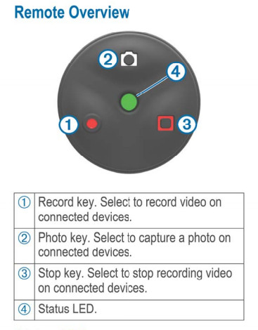
- And speaking of mystery devices, is this part of the Garmin gobi or just a VIRB remote?…

Is this a remote for the VIRB or a forthcoming Garmin gobi?
TomTom
- TomTom MySports mobile app now available
- And of course DC Rainmaker has all the details
- More on it from TomTom
The business of GPS
- Telenav Acquires skobbler, the Leader in OpenStreetMap-based GPS Navigation
- TechCrunch‘s take; and here is what GigaOm has to say
- Apple to tackle fitness market?
- Without A Buyer, TomTom’s Route Is Unclear
- Apple patent: Find you parked car with GPS
- Are Fitbit, Nike, and Garmin Planning to Sell Your Personal Fitness Data?
GPS in the news
- Justin Bieber GPS Records Show No Drag Racing
- Former Saint says he can’t navigate New Orleans without GPS
GPS tracking
- Justice Department: Feds to Pay for GPS Trackers for Autistic Kids
- GPS helped unravel Plant City police chief’s affair
- Reporter gets it wrong; RFID is not GPS
- Geo-tracking your vehicle’s license plate
- Sygic launches Job Dispatch; via Pocket GPS World
- Use of GPS technology cuts costs for fleets
- Judge: NYC can use GPS to track cabbies
- GPS tracking app helps kids catch the school bus
- Kenyan rangers fit lions with GPS to prevent them from being slaughtered
Geocaching
- Geocaching 101: Getting Started with Profile & App
- Stashers and Cachers: Geocaching reality TV show to begin filming soon
- Laser Caching Tutorial
Make Way for Tortuga from Andrew Schaffer on Vimeo.
Satellites and such
- Lockheed Martin Powers on Second GPS III Satellite in Production
- Who Carries the Gold Standard Now?
Drones
- Applanix Conducts Successful Test Flight of Professional Mapping UAS
Just geo
- U.S. map showing amount of snow needed to cancel school by county
- The top ten rail trails in Florida
- Aerial maps – A short history
- Building a Story Map
- The Slow Death of the Google Maps API
- The Top 10 Uses of Street View
- New U.S. Topo Maps for Idaho, New Mexico, Feature Public Land Survey System
- One reason why aerial images and maps are inaccurate:
Coordinates are somewhat ambiguous if you associate them with a precision (which few do). Flat pictures of a non flat object (surely we’ll agree the planet isn’t flat…) are subject to distortion.
