Garmin BirdsEye Satellite Imagery is a $29.99 annual subscription plan (though downloaded imagery does not expire) that allows you to transfer satellite imagery to compatible Garmin devices. At this point, the following series are compatible:
- Astro 320
- Colorado series
- Dakota series
- Edge 800
- eTrex 20 and 30
- GPSMAP 62 series
- GPSMAP 78 series
- Montana series
- Oregon series
- Rino 6xx series
Is BirdsEye right for you?
IMHO, BirdsEye is most helpful for folks using it in urban/suburban areas (geocachers), other open landscapes (parts of the western US), and on lakes and rivers. I find it less useful in my area, under the dense canopy of the Southern Appalachians.
Things to know
- BirdsEye imagery is downloaded and transferred to your device using Garmin’s free BaseCamp program
- These are large files and downloads can be slow, especially at peak times (like the start of the weekend)
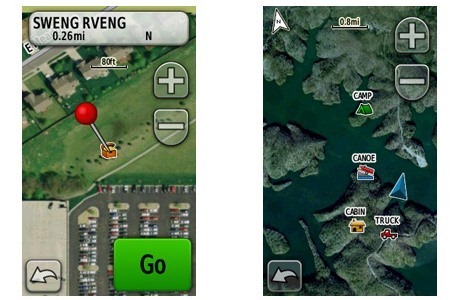
- If you have vector maps loaded, some features such as roads and contour lines will show as an overlay on top of the BirdsEye imagery (seen above, at right)
- BirdsEye subscriptions are sold on a per device basis; imagery cannot be transferred to another unit
- Imagery can be loaded to internal memory or a micro-SD card
- You can try BirdsEye imagery out before buying a subscription
- Imagery downloaded to your device or a micro-SD card does not expire if your subscription lapses (but it cannot be transferred from BaseCamp)
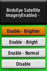
- You can adjust the brightness level (see screenshot above at right); on my 62s this is found under Setup > Map > Map Information/Select Map > BirdsEye Satellite Imagery
- A new product, BirdsEye Topo US and Canada, will let you put USGS and NRC topos on your device
- UPDATE: How to transfer Garmin map downloads after your subscription expires
- UPDATE: This page includes a BirdsEye tutorial
Sound off!
Your turn, readers. What has your experience been with BirdsEye? How do you use it? Is it helpful? What have I left out?


Here are a few things I’ve learned along the way that might be helpful. Be sure to register your GPS before purchasing Birdseye. When you do, Garmin will send you a code to use for a 10% discount on any purchases, including Birdseye. If you’ve got any old Garmin products lying around, you can register them and get another discount code also.
Even though subscriptions are specific to each GPS, the you don’t need to download the files again to use them on another unit. Just send them from Basecamp to the new unit. If you have more than one subscription, Basecamp will ask which unit you want to unlock it for. I just did this on my Montana with 14GB worth of imagery that I had previously installed on my Oregon. But you will need to transfer the files directly from Basecamp to unlock them. Just copying the .jnx files from another unit gives an “invalid birdseye file” error.
Don’t assume that the imagery won’t be useful out in the woods. In my area, it shows pretty much everything since the orthophotography was done in the Winter when the trees were bare. 🙂
Thanks Boyd. Good tips! I appreciate you taking the time to share them.
HI,
Any idea where I can get a preview of what imagery is actually available on birdseye? I live in Malawi, Africa and after getting the subscription I have noticed that High res imagery is not available every where. Just like in Google earth where in this part of the world some of the coverage is not that good.
I have looked everywhere on the web for this, but have so far hit a blank!
Looking for a birdseye specialist/expert!
cheers,
Mick
Do you have a compatible GPS – Oregon, Dakota, Colorado, GPSMap 62, etc? If so, then just connect it to your computer and run Basecamp. You can then download all the imagery you want for free and use it on your computer. You don’t need to pay unless you want to unlock it for the GPS itself.
Otherwise, I don’t think it can be done (although I suspect a hack might be pretty simple) 😉
Yes, do have an Oregon 300.
The issue is that with limited bandwidth, I need to download an area before I can see the imagery quality. I followed the link form Guido below (thanks Guido!)
http://dgl.us.neolane.net/res/dgl/survey/Oracle_Coverage.jsp?deliveryId=6206936&id=
And discovered that the imagery for my part of the world is largely 15-30 meter resolution. Which is pretty useless to all intents and purposes. A pity as I love the idea of downloading the imagery for my use.
cheers,
Mick
I guess I don’t understand what you want then. If you have an Oregon 200, just connect it to your computer and run basecamp. Choose a small area with which you’re familiar and download it. You can then see exactly what you get with the subscription. It will even allow you to send a small sample to your Oregon for free – IIRC it is about 1 mile x 1 mile at the center of the are you have downloaded.
Your question was “Any idea where I can get a preview of what imagery is actually available on birdseye? “. And the answer is YES – just do as I have described. You can choose a very small area to download and let it run all night (or whatever). However, if your connection is really slow, it may not work well for Birdseye. It seems like the procedure I have described would also be a good way to find out whether it’s even practical, aside from any image quality issues.
I have been downloading birdseye since it was available. As written above it is not very usefull in a woody surrounding.
But when in a desert of water or even city it can give a lot more info for just a small price.
Coverage is differant thrue out the world. See also http://dgl.us.neolane.net/res/dgl/survey/Oracle_Coverage.jsp?deliveryId=6206936&id=
With the latest firmware you can see the differ in brightness ( http://www.gps-info.nl/garmin_birdseye.php#3 in dutch)
I Also tried birdseye select with give a lot more info, but there is a maximum of square km to download. Download is done by credit.
My oregon was replaced, the birdseye subscription was transfered. It is possible to load the images again thrue basecamp.
guido
If the BirdsEye subscription was transferred, yeah, I woud think you could reload them. See Boyd’s comment above.
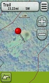
I find it useful to get a better idea of the vegetation and terrain. Sometimes I can see trails, roads, and objects that are not on the map.
I use Delorme, and wonder how they compare?
I believe they are using the exact same imagery. Can anyone verify that?
I live in a rural area in the mountain northwest and use Birdseye quite often. Working in natural resources I’m contantly using birdseye to pick up wetlands and small ponds that no other maps do either because they were recently created (beaver) or USGS just hasn’t mapped them. I also hit a few rivers in the summer and if you’ve been out there you know that vector representations of river channels are often not as accurate as one would like. With BirdsEye, you can see if that braid reconnects to the main channel, which way to go at a fork, has the river migrated from the old USGS survey, etc. Great for floaters!
I’ve learned not to trust most vector road maps, especially in rural areas, because they are often quite lacking and innacurate. Dirt roads, two tracks, and most trails are unmistakable on a BirdsEye aerial photo.
Hunters sholdn’t be without BirdsEye either. Knowing what kind of habitat is just over the ridge or around the bend (meadow, forest, clear-cut, wetland, etc) has proven to be invaluable in attempting to strategize a hunt. For $30 it’s plenty worth the extra advantage it gives me when up in the hills.
I’ve found that Birds Eye imagery downloads incredibly slowly. As a matter of fact, unless I rename the download constantly to jumpstart the download process every 1% or so, it never downloads. Just stalls forever. I’m on a 66Mbps/16Mbps connection, and it takes me several hours to download the simplest of map areas.
I’ve been using BirdsEye topo more than the aerial imagery recently, but when are you doing it? Peak load on their server may be weekends, especially Saturday mornings. Peak load for your ISP is likely prime time Netflix viewing hours.
Hello guys/gals,
I recently ordered a Garmin eTrex 20 to supplement my Garmin gps 12 (15+ yrs. old).
I’m pretty excited about it, as obviously this unit is a tad more advanced than my old one 😉
Regarding Birdseye Satellite imagery maps. Would you recommend loading directly to the internal memory of the unit or should I buy a micro sd-card? Internal memory is 1.7 gigs I think.
If saving to internal memory, can you delete the file if need be, and reinstall it later from your computer?
Congrats!
Either will work, although if you load it to a memory card, you don’t have to worry about the subscription expiring…
http://gpstracklog.com/2012/06/how-to-transfer-garmin-map-downloads-after-your-subscription-expires.html (I think this will help answer some of your questions.)
First let me thank Rich for his great blog as well as everyone else for putting up great questions and comments. I am looking at buying the Birdseye Satellite subscription however have a few questions first. It seems you have to have the gps connected to Basecamp in order to download the files. However, can you view the satellite views that were previously downloaded on Basecamp even when the device isn’t connected? If so I plan on downloading to my Montana but using it with a new Rhino 655t for real time tracking with my laptop. Is that doable?
Yes, that should work fine. Also, if you have more than one Rino, check out the BaseStation portion of this post… http://gpstracklog.com/2012/08/more-on-garmin-adventures-basestation-and-tempe.html
Oh, and of course, the imagery will have to be loaded to your hard drive and not just the Montana…
http://gpstracklog.com/2012/06/how-to-transfer-garmin-map-downloads-after-your-subscription-expires.html
I recently purchased the garmin astro 320 and downloaded the basecamp program then loaded to birdseye maps. after downloading them to the device, when i turn it on it says invalis jnx. Anyone know what the problem is and how to fix it?It would be much appreciated!
Do you have a BirdsEye subscription for the Astro 320?
Hi
I spent a very frustrated day yesterday trying to download sattelite imagery to my new garmin etrex 30 without success.
I have a laptop running on windows vista. I downloaded base camp. I connected my etrex30 (which I put an 8GB micro sd card into) and tried to select an area to add Birdseye sattelite image to, and it told me there was not enough space! Base camp only seemed to recognise the internal memory of the device and not the sd card. It would not let me select the sd card of the device to download to either.
How can something that sounds so simple to do be so frustratingly difficult?
Please tell me what I did wrong and how to get the sattelite imagery onto my device!
Also, I have another query (dreamt up overnight) I also have the garmin navigate sd card (for uk and Eire)…is it possible to get this onto base camp and overlay it with the Birdseye sattelite imagery and transfer it back onto my 8gb sd card to use?
I bought the etrex30 for two reasons…1 to try geocaching with my family (we’ve not done that before and this is our first GPS device so were not familiar with either)
The second reason is that I like to go exploring with the kids in their school holidays, we often use the trains and get off at random stops to find out what’s there..I had been using google maps on my android phone to help find our way (nearest restaurant, places of interest, cash point, way to the beach etc) but this really sucked the battery life out of the android phone (if out a whole day) so I figured the garmin etrex could take over this role too, leaving my phone enough battery to work as a phone, and hopefully being accurate as having GPS and glonass sattelite use.
Are you following these instructions?
You may need to create a Garmin folder on the card first.
I’m not familiar with the Garmin navigate card. If it is a Garmin card (and not something you loaded onto the card), you can’t transfer it off the card. But you could possibly overlay BirdsEye imagery that is on your internal memory.
Thank you for your reply Rich, that does help a bit. I will try to make a garmin folder on the sd card and then follow the above instructions.
I don’t have enough internal memory on the garmin etrex 30 to put the entire British isles in birdseye sattelite imagery on there to use in conjunction with the road mapping on the garmin navigate sd card unfortunately.
Would it work if I had the garmin navigate info in base camp (as a download rather than using the garmin sd card…in other words I’d need to buy it again as a download)…do you think then I could combine it with Birdseye sattelite imagery onto my own sd card to use in my device?
I received a Garmin Etrex20 for Christmas, I’ve been having fun with it but feeling that I’m wasting my time strugging with Basecamp and Birdseye Imagery. In my region I am finding Birdseye imagery is very poor compared to the images from GoogleEarth. I am in Southern Ontario Canada, I assumed Birdseye uses the same images as GoogleEarth but even the Highest level detail selected, it doesn’t come close. GoogleEarth will recognize my Etrex20 and show my paths, with out extra downloading and great detail, I’m thinking I wasted my money on Birdseye Imagery too. With less time invested doing a quick search on the interenet I found this out.
I had the same expierence. Depending on your area the subscription could end up being a waste. Here is a cool tool that may work for you. Caltopo.com has USGS and Google Earth exports as a kmz file. you can try to export the map files and load onto the gps. Although it didn’t work on my Rhino it may on the etrex. You can also export USGS topo maps into google earth. pretty nice site. here is the blog with instructions http://caltopo.blogspot.com/
Nice resource. Thanks!
Hi there, I’m looking at purchasing a gps for tracking and hunting, to be used in Uruguay and Chile, both in South American, does Garmin or any other devices such as Magellan provide mapping for these countries and areas.
Many Magellan handhelds have a worldwide NAVTEQ map that *may* have very good road coverage for those areas.
For topo maps, it is more common to find maps for Garmin units, and street maps are definitely available.
im a coon hunter and a one finger typer. ive had a astro320 for 2 weeks and have got birdseye and birdseye topo and cant figure how to download the stuff. wher can I learn about this stuff nin regular englishy?
Hi
I purchased the imagery for my Oregon 650 after reading your blog. Each time I try and connect through base camp i get the following error message
“You do not have an active subscription for this product on this device. You may preview a limited version of BirdsEye for free.”
I have a receipt for my payment and myGarmin account says I have paid for it? What gives
Thanks for any advice
I just purchased aastro320.down loaded base camp &puchased birds eye.have down loaded some imagery.it shows that it has been put in my collections,and transferred to my astro 320.but when I turn it on all I see is roads no imagery. I checked to make sure the maps r on.what is goin on this is very frustrating.please help,,,,,,thx
The most recent image available (just downloaded 2 weeks ago) for my hunting land and cabin is from 2010 or earlier because the cabin was built in 2010. When I contacted BirdsEye support, they told me they just updated their software in 2014. I replied that the image I downloaded was 2010 or earlier. They replied that their software was updated, not their images. In fact, they have no idea when their images were captured. When I complained that both Google and Bing have very current images, BirdsEye support replied that they don’t get their images from servers but directly from the satellites. What an inane and ridiculous answer! How stupid do they think we are? Directly from the satellites? Only every five years? Come on! I won’t renew and pay for obsolete images!
I also read elsewhere that when my BirdsEye subscription expires (they won’t refund unused pro rata), all images I have downloaded will become unusable!