Sunday, March 18, 2012

Use GPS to Discover Local Art

appoet-trans

GPS has been used for a lot of really cool things over the years, but this idea has to be, by far, one of my favorites. Imagine this: you’re walking along through the park, when you see a beautiful memorial statue sitting under some shady trees. In your pocket, your phone buzzes and you pull it out to discover a poem written about that very statue by one of the many local poets in the area.

While you read the poem, you are surrounded by the exact same scenery and imagery that inspired the rhyme on your device. It’s almost like the poet is standing right next to you. Now imagine that you can do the same with messages, music, photography—-the sky is the limit. You can connect almost anything to a GPS coordinate to create your own puzzles, messages and secrets right in the open. It’s genius, and you can do it right now. read more

Pinit App Combines GPS With Social Media


logo present

There is something about photos of vacations that just stirs the mind and always brings a smile to my face with each captured memory. While there are plenty of ways to share these moments with friends and family, most traditional social media is so cluttered with junk—be it videos of cats, quizzes, games or other distractions—that such important moments tend to get lost. However, UK teen Tyler Ball is looking to change the way that people share their travels and photos with his new app Pinit.

Created to act almost like a digital travel diary, Pinit allows users to geotag photos and place a ‘pin’ on a location connected to a photo or status, and a memory. Over time, users can create their own world maps with pins showing all of the places they have visited. Friends and families can follow each other and comment an even ‘like’ photos and statuses. read more

Smart Tracker Blows Through Crowdfunding Goal

20150406015145-SmartTracker

I am always a little hesitant to write about anything that gets funded through Indiegogo, as the site is slightly less reputable than Kickstarter. And while all tech startups are a little risky, ones on Indiegogo seem to be even more so. However, all of that aside, today I discovered this cool little GPS tracker that does, well, everything. The flex funding campaign gives me a bit of pause, but with more than three weeks left in the campaign, it has already surpassed its goal and is barreling towards the stretch goals.

The Smart Tracker, honestly, almost sounds too good to be true. With an expected delivery date of August of this year, the device costs around $180 on Indiegogo (there are still some Early Birds left for $130), and I wouldn’t be surprised for it to cost quite a bit more once the campaign ends. However, in the world of GPS trackers, a sub-$200 device really is pretty cheap. read more

Game Golf Launches Free GPS Tracking App

198723

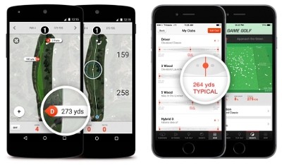
In the world of golfing, GPS can play an integral role to better understanding the game and improving with every swing. While there is no shortage of expensive wearables for golfers to choose from, sometimes it can be hard for casual players to justify the additional expense. Well, GPS GOLF announced a new free GPS GOLF Tracking App today that will give players a glimpse of how GPS can help better improve their game.

“If you don’t truly understand your game it’s hard to improve. The free GAME GOLF Tracking App allows golfers to see their shot performance in real-time, something which many amateur golfers will never have had access to before,”John McGuire, CEO of GAME GOLF said in a statement. “Further, it affords everyone access to the GAME GOLF platform to gather stats, collect data and share their game with friends, family, coaches and instructors.” read more

See History through GPS and Augmented Reality

pivotapp

Imagine walking down a boulevard on your vacation or even in your home town. You see a building with a sign saying it was built in the 1800s, so you pull out your smartphone, launch an app and point the screen at the building. Instead of the building infront of you, you see a photograph of the street and the building facade, showing what it looked like 75 years ago along with historical information on the building. Well, with the app Pivot, that’s exactly what you’ll be able to do.

Using GPS and augmented reality, Pivot is designed to act almost like a time capsule, allowing users to peer into the past and learn significant and interesting facts about historical locations. Using geotagged images and GPS technology, the app will allow users to pull up images of sites and allow users to peek into the past. This isn’t the first app to do this, but it’s still a cool idea and a neat way to use GPS technology. read more

TomTom GO Mobile Launched for Android

TomTom GO Mobile

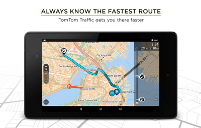
While no one can deny that dedicated GPS devices are more reliable when it comes to directions and navigation, smartphones are just so convenient many consumers have a hard time justifying the additional expense on a separate device. Well, in order to stay on top of consumer trends, TomTom announced earlier this week that it was debuting a new mobile app for consumers to replace the old TomTom Navigation App.

This new app is called TomTom GO Mobile and like the old TomTom Navigation app, includes almost exactly the same features as you would find on a dedicated TomTom device including traffic, points of interest, offline maps, 3D imaging, quick searches and more. The app is free to download on Google Play but an iTunes version has not been released. The app is available in a range of countries. read more

GPS App Helps Those in Need

donafy

Smartphones aren’t just for Instagram and bird-related games. A smartphone app creator in Philadelphia wants to encourage you to use your device for micro-philanthropy to help the needy. And, all it requires is the push of a button.

This week, the app Donafy–a play on the words ‘donate’ and ‘notify’–debuts on iTunes for the Philly area. Created by a tax attorney in the city who wanted to give people an easier way to help the needy and those on the street, Donafy is meant to make doing your part to help as simple as pressing a button. read more

HERE for Android Adds Indoor Maps

HERE

We’ve talked a lot about indoor location and navigation in the last few months. Undoubtedly, it’s one of the main movements in GPS right now, and there are dozens of companies that are working towards finding a solution to helping people find their way inside of large buildings.

One of the newer names to the indoor location scene, Nokia, announced earlier this month that it will be including indoor mapping of more than 11,700 locations in 76 different countries as part of its HERE Maps app, available for Android. The company hasn’t released a whole lot of information about the indoor mapping or how it works, but from what I’ve seen, it looks pretty decent. Maps are 3D digital renderings of buildings, and users can swipe, swivel and probably even zoom to their hearts content while searching for directions. read more

App Provides Navigation Inside Stores

gpsindoor

Imagine it: you walk into the store with a short grocery list in mind. You input the items in your phone and an app immediately maps out the most efficient route to each item on your list. You follow the flashing blue dot from one item to the next, and the phone vibrates on occasion, alerting you to coupons and advertisements for relevant products as you walk past. This might be the indoor GPS of the future, and it’s available now. read more

GPS App Provides Location to 911 Dispatch

bluelight logo

While not directly related to the kinds of GPS articles we normally write, location accuracy in emergencies is a pretty hot and important topic in the world of GPS and is definitely something worth talking about. This topic has actually been in the news several times in the last year, as it was discovered that 911 emergency calls made from cell phones don’t provide the same location information to dispatchers as landlines.

As it turns out, cell phones really only provide a three to four block radius for possible location to dispatchers, requiring them to either try and figure out where a caller is vocally or to simply search for the person. However, an app has been recently released that utilizes GPS to provide better location to dispatch during emergencies. read more