UPDATE: DeLorme has discontinued the SPOT Satellite Communicator in favor of their own product, the DeLorme inReach, which offers two-way communication and works as a standalone device or can connect with the PN-60w or with the iPhone or Android smartphones.
A serious tool for backcountry adventurers
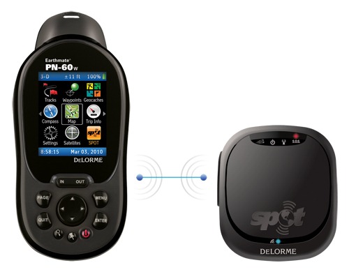
Call me crazy, but I love all day mountain bike rides where I go so far back that I’m unlikely to see another human; the more isolated and rugged, the better. I prefer to do these with my biking partner (the most wonderful wife in the world), but all too often I’m out there solo. What’s a crash-prone, wilderness-seeking, aging mountain biker to do? Get the Delorme Earthmate PN-60 with SPOT Satellite Communicator, that’s what. This combo (the two separate units are shown above) is the first consumer product to combine a GPS receiver with the ability to compose a custom message in the field and send it via satellite.
Disclaimer: Be Safe
Having said all that, I feel compelled to add that this device is no substitute for common sense, preparation, proper gear, map reading and survival skills, and general wilderness savvy. Be safe out there!
Note: I’ve decided to break this review up into two parts. Today’s installment will focus on the ability of this device to send messages and location information in areas with no cellular coverage.
A full review of the PN-60w itself will follow in a few weeks.DONE: Here’s my DeLorme Earthmate PN-60w review.
SPOT Communicator basics
Here are the first things you should know about the SPOT Satellite Communicator:
- It will allow you text friends, send an SOS, and post to Facebook and Twitter, even where you don’t have cellular coverage
- The SPOT also allows you to share a track progress Web page, either publicly or privately (password protected)
- It requires a subscription plan for these capabilities, priced as follows:
- $99.99/year for Basic services (minimum service level), including SOS, Check-In/OK, Send Pre-Canned Messages
- $49.95/year for 500 Type & Send text messages ($0.10 per msg)
- $29.95/year for 100 Type & Send text messages ($0.30 per msg)
- $0.50/msg for A la Carte Type & Send text messages (individually priced)
- $49.95/year for Track Progress
I’ll discuss message types shortly, but you can easily get by with the $99.99 plan, unless you want to post your adventures live to the Web.
Shown below is a coverage map:
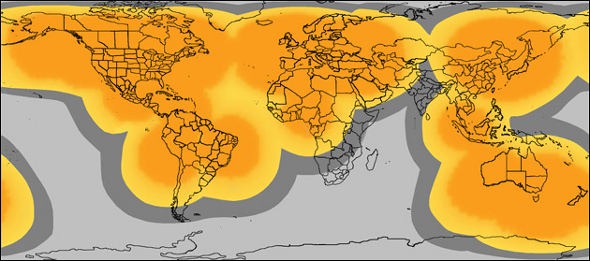
The darkest orange color represents areas with a 99% or better chance of sending a message within 20 minutes. In the lighter, yellow color, this drops to 96-99%. Dark grey is reduced or no coverage, while there is definitely no coverage in the light grey areas.
I’ll also note that, while coverage is extensive, you can currently only activate the SPOT with a credit card bearing a US or Canadian billing address.
Spot Communicator Setup
I had a little trouble out of the gates, but not too much. When I tried to pair the devices initially, I got a message that both needed a firmware update. This was done via Topo USA (mapping software included with the PN-60w) Sync. You also have to go to findmespot.com to set up your account, contacts, etc., and export device settings, which requires a plugin. It wouldn’t work for me in Chrome, but I had no problem in Firefox.
SPOT Communicator performance
The first thing I learned in testing the SPOT is that it tries to send texts, Twitter and Facebook updates three times (once every ten minutes over a 20 minute period). When I interrupted it after the first or second try, the messages typically weren’t received. The second thing I found out is that the SPOT isn’t a multi-tasking device. You can’t send texts while having the unit post your coordinates to your track progress page. It’s one or the other.
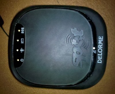
Also be aware that placement of the Communicator module is important. I typically test in mountainous terrain, under canopy, on a mountain bike – a good testing environment for a GPS receiver, so I was curious how the SPOT / PN-60w combo would perform. The manual says it needs a clear view of the sky, and is “not reliable…in very dense woods.” It also suggests that you orient the Communicator so that the logo faces the sky and keep it at least 12 inches away from other GPS devices.
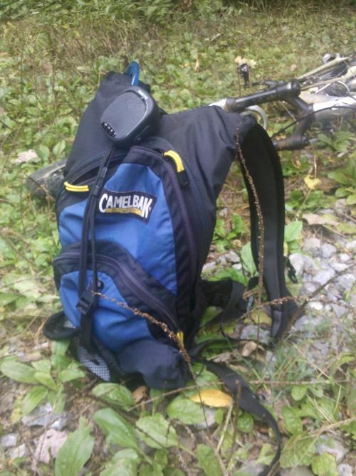
On my first outings with the device, I clipped the SPOT module to the mesh pocket on the back of my CamelBak pack. The performance was very disappointing though, and I was afraid I would need to rig a handlebar mount or put a rear rack on my bike. But I took an intermediate step and moved it to the top of my pack as shown below. This was all it took to get a decent level of performance.
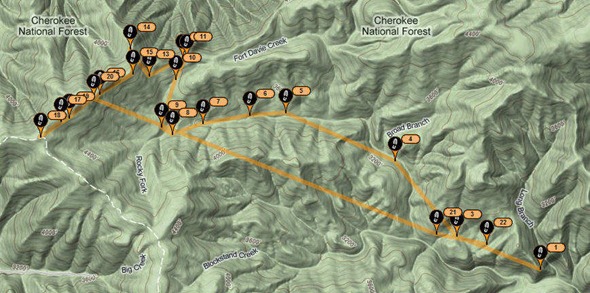
The screenshot below shows the track for one ride (an out and back), with waypoints for each position the SPOT Communicator transmitted:
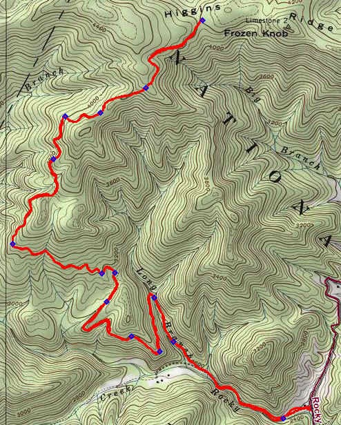
Pretty darned accurate, I’d say. And SO much better than the first generation SPOT Satellite Messenger.
Performance hiccups
I saw only minor issues in terms of data transmission:
- Sometimes it seemed like there were server delays in transmitting data, but I never saw a delay of over an hour.
- An out and back track on the findmespot.com page (pictured below) reveals trouble tracking in some situations. The slow uphill was no problem at all, but the faster downhill through a deep cove resulted in no points being received for several miles. Judging by the uphill track though, had I crashed and not been able to move, the unit should have been able to accurately relay my location.
- On one outing, the SPOT device stopped tracking me after changing the batteries in the PN-60w (even though the PN-60w reported messages were being sent); the next time I needed to change batteries, I rebooted the SPOT and had no problems.
I’ll also mention that, while you should be able to see the last 30 days of my testing on my “Track Progress” page, findmespot.com is showing only the last week of data, despite me changing the settings to 30 days, so it may be gone by the time this gets posted. You can however, export trips to a SPOT Adventures page, and you can see a recent trip there.
Custom messages FTW
(That’s “for the win” for those of you who don’t live in social media land – it’s a good thing.) Beyond its ability to send messages sans cellular access, another killer feature is the custom messaging capabilities. Unlike personal locator beacons (PLBs) or even the standalone SPOT devices, you can type a message (up to 41 characters) and say exactly what is going on: “Hurt leg but can get out; will be late.” No longer do you have to choose search and rescue (SAR) or nothing. Of course, one fear is that folks who should call SAR will ask friends for help first, possibly endangering themselves and others. This is counterbalanced by several obvious advantages though. For one thing, you can include a text with an SOS and let SAR know some details – are you lost or hurt, is it life-threatening, etc.
In the first screenshot below at left, you can see options to post to Facebook and Twitter. In the middle screen, I show a drop down of pre-defined groups that you can send messages to. You can set these up at http://findmespot.com, and have them go to email and/or text.
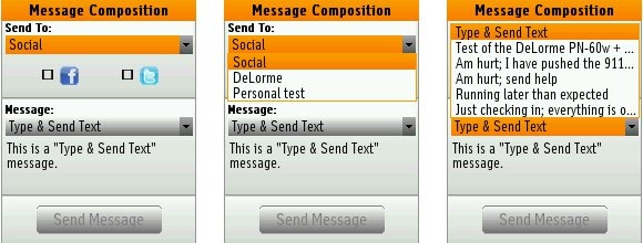
In the last image above, you can see custom messages I set up at findmespot.com. You can set up as many as 14 of these, with up to 111 characters per message. These are included in the basic service plan, so you may be able to get by with the ala carte type & send pricing, referenced earlier.
Here’s a quick video showing the interface (still working on my video technique!):
Hardware notes
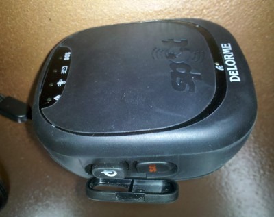
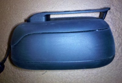
The SPOT Communicator device can be operated independently of the DeLorme PN-60w, for sending an SOS. The SOS button is located under a cover to prevent accidental engagement (see image below).
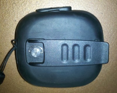
One other note before I wrap things up; the clip on the back of the device is quite tight and secure (see images below). Even so, I looped the lanyard for extra security, but I doubt that this thing is going to pop off of a pack strap.
Conclusion
Awesome. The DeLorme PN-60w with SPOT Satellite Communicator is almost a must have for those of us venturing far off the beaten track. The more risky your adventures (off-trail, solo, etc.), the harder it’s going to be to pass this one up. I’m not prepared to make a recommendation until I complete my PN-60w review, but I expect that I’ll be ponying up for one myself (the tested unit is a loaner for review). For obvious reasons, it may be easier to convince my wife of the value of this than some of the other GPS receivers I’ve purchased recently!
Compare prices on the DeLorme PN-60w at these merchants:
- Check the current Delorme Earthmate PN-60w
price at Amazon
- Get a great deal on the DeLorme Mapping Earthmate PN-60W Handheld GPS with SPOT Satellite Communicator
at J&R Computer/Music World
- Check out the DeLorme Earthmate PN-60w GPS with Spot Satellite Messenger
at REI.com, where satisfaction is guaranteed and members get 10% back on eligible purchases
- Get the DeLorme PN-60w + SPOT at Cabelas.com


Succinct yet comprehensive; based on my experience with the Spot Communicator and the PN-60w I concur with your take (and can’t think of much to add). I’ll comment that I’m a little surprised at how well your transmissions were received given the forest canopy under which you were riding–those are challenging conditions for the Spot. If I have a message to transmit, I’ve found it worth my while to search out some open sky (even a bit helps the probability of a successful transmission). Your reported experience is a good example of the importance of orientation…the Spot is pretty direction-sensitive.
If the track you showed was taken from the PN-60w, the accuracy (or should I say the match-up) of the transmissions is to be expected, as the Spot relays the coords supplied by the GPS–it only transmits its own coords when operated by itself.
Looking forward to your PN-60w follow-up.
Thanks Max. It’s funny how it takes weeks to do a succinct review!
And yeah, I was a bit surprised at the transmission success. In many places the aspect is north. I’ve seen reports that the ideal is southern exposure; rare in the place I was testing.
It takes weeks to do comprehensive. It takes years to do succinct. 8)
Nice review Rich. I’m actually surprised how well your tracklog recording worked. I’ve been using a SPOT II all summer and I’ve found the tracking feature to be almost useless even with the unit mounted right up on top of my shoulder similar to what you did on your c-back. Do you know if this SPOT is somehow improved over the SPOT II?
-Scott
I don’t. It may very well have improved transmission capabilities. I’m assuming your trouble is that you aren’t seeing messages sent (as opposed to inaccurate coordinates).
It could be that reception won’t be as good when hiking. I’m a bit crouched on my bike, so the Camelback may have a better view of the sky then. I’ll be testing it soon on some hikes.
That’s correct, I’ve gone on several 5-10 mile hikes and I’ll end up with only one or two track points. I’ve had better results with “I’m Okays” the “Pre configured message” but as you suggest it may be as a result of the better orientation when I remove the SPOT from my pack and hold it flat.
Looking forward to the rest of the review.
-Scott
Nice review. I have something to learn for writing one up.
I hike in the PNW under heavy canopy and exrreme slopes, most recently in th Washington rain forests and my experience is much the same as yours. The Spot/PN dynamic duo tracks very well under these conditions. I’m finding as long as the GPS has a relatively good signal, chances are pretty high I can get a Spot message out. Two maps I saved:
Hoh Rain Forest
http://i1231.photobucket.com/albums/ee520/TotemLake/Spot2.jpg
and
Baker Lake
http://i1231.photobucket.com/albums/ee520/TotemLake/Spot1.jpg
Nice! How are you carrying the SPOT? On your pack? Shoulder strap?
Also, I’d like to link to your PN-60w review. Is there any way to get a static link to that page, or is it all flash, or…?
Thank you for the honors. I had to build a separate page instead of the mini-page you read. Please feel free to use
http://www.wix.com/totemlake/hotm/pn60w
As for carrying the Spot, I toyed with two styles. I carry the PN on one shoulder strap, so the Spot was clipped and tethered to the other shoulder strap during the Baker Lake hike. On the Hoh River hike, it was inside the top pouch of the overnighter pack I was carrying. Storage slop was the reason for the poor positioning for the first two hours on this hike. With a little judicious packing, there was one less item I had to worry about getting hung on branches.
Didn’t mean for you to go to any trouble! I’ll link to it from the (forthcoming) full PN-60w review.
I’m glad to see others are getting good results, and that my success wasn’t a fluke!
No worries! I had a chance to learn something new. I’m looking forward to reading your comments about the 60!
Nice review as always! I’m looking forward to part 2, because the PN-60W is half the paired system with the SPOT device.
Well from the looks of the map I hope no one is planning a trip to Hawaii…or India…
Yep. Interesting that someone got a tweet off from the Everest summit the other day though…
http://twitter.com/ELexplore/status/27418932143
I just purchased a PN-60w with spot to get rid of my EPIRB.
You mentioned that the spot device needed a firmware upgrade? I updated the firware in the PN-60w but can’t figure out how to upgrade the SPOT.
Maybe that’s why I’m having trouble sending messages…
The firmware upgrade was for the GPS device only; nothing yet for the SPOT. I’d recommend bouncing your problem off the PN-60w users at http://forum.delorme.com in the PN-60w section.
In case I’m wrong about the firmware update regarding the SPOT (see Rich’s comment below; I concur that if anything has been updated on the SPOT it’s via the PN-60w), take a look at Setup/About this device. The installed firmware versions will be listed.
If not currently paired, it will show something like “3.1.563103 / na”
When paired, mine shows “3.1.563103 / 1.16 / 1.9
The first number is the GPS firmware version, the second is Spot-related firmware for the GPS, and the third is the firmware on the Spot itself. I’m not exactly sure about those last two, but I know they are Spot-related.
I got an early message (first use) saying both devices needed firmware updates. This appeared to be done when I synced the PN-60w via Topo USA. I’m assuming it handed off the firmware update to the SPOT the next time they were connected. I could well be wrong about this though, so if it doesn’t work this way for you, I’d certainly follow up on Max’s suggestion.
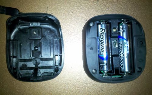
I contacted Delorme, and they said there is no firmware upgrade for the SPOT right now, but that if there is, it goes in through the mini-usb connector between the batteries.
I also asked them why the satellite led doesn’t always blink green when the message is sending, and they haven’t replied. My experience is that unless the satellite icon blinks green when sending a message, the message doesn’t get sent. I’m wondering, maybe it’s better to “point” the spot towards the part of the sky where the satellite is? How does this system work? Are there multiple satellites up there? If I’m in the southwest US, is “my” satellite above the middle of the country? I’m still deciding whether to keep this unit as my emergency signaling device, since I go off road frequently without cell coverage by myself. I carry an EPIRB, but would rather use this, I just don’t know how well it works…
Yes- gps works by aquiring signal transmissions from multiple satelites – the more satelite “in view” by the device the more accurate the location will be. Satelites revolve around the earth and are continually moving across the sky. There are different qualities of gps – survey grade being the highest and modern units incorporate “corrections” for errors from changes in the orbits of the satelites, earth’s rotation etc. etc. Pointing to the centre of the country will not help – although pointing to where current satelite locations are may. Some gps devices had a screen which will show you a overhead skyview and shows how many satelites may be above you at the given time. In the U.S you should have no issues with having enough satelites overhead at any time during the day. If you are going into northern Canada or other countries the number of satelites available may vary – and hence your connection – but should still work.
I’m sure of what I saw. Just wish I had a screenshot!
Later on, I did see that the SPOT has a mini-USB connection in the battery case, which could be used for updates.
On the DeLorme forums there is a thread on orienting the SPOT south, but I never had to do that. It does take a while to get used to the SPOT and the way it works. I think I did two trips before I even got a single message off.
So here’s the Million-Dollar-Question…
When your lying there with a compound fracture in the middle of nowhere, will it work as reliably as a GPS enabled 406 EPIRB?
I wish I could find out. I guess I’ll test it in the next few weeks, I think I have 30 days to return it if need be…
Yep, keep testing. I became pretty confident of its abilities, but it took quite a few trips to get there.
So doing a little more research, a PLB (handheld EPIRB) transmits at 5 watts to a moving weather satellite. How much power does this little spot put out, I wonder?
Have you completed your full review? Whn do you think it will be published? Can you incorporate the PN-60 WITHOUT SPOT in your review?
If all goes well, it will be posted tomorrow (Tuesday, 11/2) morning. And yes, the PN-60w review will be more about the receiver itself, sans SPOT.
Great. Your site is excellent. The best I have seen. I am looking to upgrade my old Garmin. I am down to the Garmin 62st or the Delorme PN-60. Do you have a preference? It would be primarily for hiking and hunting. What would you recommend?
I’d get the PN-60w + SPOT if you do a lot of solo stuff that could get you into trouble. Otherwise, I’d go for the Garmin 62 series for the better interface, free maps, improved track navigation functionality, etc.
Hello Rich,
I am really interested in acquiring the PN60W, but I still have some doubts. If you could help, I will greatly appreciate:
So, the thing is. I am an Adventure Racer and I am going to compete in the Patagonian Expedition Race in the coming february. My idea is to take the PN60W so that people can follow my team’s race progress, not only with location, but also with some short messages of what is going us with us. My questions are:
– Do you think this will work as far as Patagonia?
– I am a resident of Brazil, but have friends in US. Is a credit card with american address all I need to make the system work around the world?
– Will the batteries last for 6 days straight?
– Do the PN60w comes with world wide maps? What kind and with what resolution?
Well, I appreciate with you could help with these questions.
Kind regards from Brazil.
Marcelo
Adding to Rich’s comment below: if you were to use AA lithium batteries, you might get two day’s operation per set, perhaps more with power saving enabled. The SPOT itself should get by on a single set.
SPOT coverage looks iffy to me, too…it would appear that you might do OK in northern Patagonia, but poorly in the southernmost region.
Maps look like the biggest problem. DeLorme does have a world-wide data set that is prohibitively priced for individual use. They have mentioned an intent to sell more affordable regional sections, but there is no word as to when these will be available.
I took a look at the Patagonian Expedition Race web page photo gallery. That is some of the most spectacular scenery I have ever seen!
It looks like SPOT coverage there could be iffy. My understanding is that A US credit card will work. The PN-60w batteries will not last for six days. You would probably need to change them daily if you want to have them going for 10-12 hours a day. There is no map coverage for that area. There may be Sat-10 aerial imagery, but I’m not sure about that.
Thanks Gentlemen,
I will call DeLorme directly and see if the PN60w is a viable tool to carry along at the Patagonian Expedition Race so that people can follow us. After all, Expedition Adventure Races lack support mainly due to the fact that people cant really follow a race with real time information. I truly hope new technologies such as GPS/SPOT could evolve and help out with the sport, which is just so great.
Thank you all so much for the atention given,
And if you feel like it, follow our team through the race at FaceBook, Xingu Aventura or Tweeter @xinguaventura,
Cheers from Brazil,
Marcelo
Team XINGU
Hi Marcelo,
I am with DeLorme and would be happy to try and help you. As Max stated, we do have worldwide maps but have not yet made those available for consumers (only for the US Govt, NATO, and other HADR agencies). But I think we could set you up if the live consumer service is not ready in time for your trip. I don’t want to publish my phone number and email here so instead please contact me on Facebook on my personal page. I am the Caleb Mason in the Portland Maine network. Just send me an in-box private message there and I’ll see what we can do. Thanks.
Team, I currently have a garmin 60csx. I am thinking of buying a Delorme pn-60w / spot. I carry my gps in my chest pack while I am backpacking. In this position, the garmin antena is pointing straigt up. On ridge and scrambling routes…the track log is very acurate. My question is, will I get a similar accurate track log with the Delorme pn-60w in this position? I can not carry the delorme “FACE UP” while I am on the go. Is there any truth to the fact that the delorme antena has to be “face up” to be accurate? If so, this will be a deal breaker for me. I already own a SPOT II, so this combination (garmin / spot II) works fine. I just would like the capability of the free-form text message.
Thank You.
Rich
Rich, I’d say the answer to your question is yes and no. The 60csx has a quadrifilar antenna, whose optimal receptive orientation is vertical, as you described. The PN-60w has a patch antenna, whose optimal reception is horizontal…but the key word is “optimal.” In common use, I find my PN-60 works just fine for accuracy thrown into a jacket pocket. But for marginal receptive conditions (e.g., heavy foliage), reception will be better face-up.
Most of the time I don’t worry about it, but if I’m in a situation where I want maximum accuracy (e.g., recording a track to mark a trail on a map), I secure the PN-60w to the top of my pack strap. Another alternative I sometimes use is an external antenna (one needs a re-radiating antenna because there is no external antenna jack). Although that works for me, I realize not everyone will see those solutions as acceptable.
REI has the PN-60W with SPOT on sale today for $350
Actually, it’s $369.99…
http://bestgpsdeals.net/rei-com-winter-gps-sale/914/
But that’s a pretty damned good deal!
Just ordered a Oregon 450t but want to get a spot unit as I hunt solo and my wife would like me to have a spot. I will be using this unit mostly for hunting but also hiking with my family. Can I down load free maps like you can for the garmin unit. Thanks
No, but the DeLorme units come bundled with Topo USA.
Would one unit be better than the other for backcountry navigation. Which unit would be better for following trails in Nation Forests?
Thanks
Thinking I might take back the Oregon and get the DeLorme PN-60w with SPOT, but I really like the bigger screne?
IMHO, the Oregon is better. But only the PN-60w lets you communicate from the backcountry. Very tough choice.
I’ll add… I think the Garmin is easier to use, and I really like the advanced track navigation feature… http://gpstracklog.com/2010/07/navigating-tracks-on-the-new-garmin-handhelds.html
Otherwise, the DeLorme is just as good for backcountry navigation.
Hi Rich,
Nice review. I noticed a number of negative comments regarding the lack of tracking messages when moving downhill. On a mountain bike I have to think this would be 15-20 mph. Would the unit function at all on a quad moving 30-60 mph? I still like the message feature, but tracking may not be possible. How is the “bread crumb” feature on the PN-60w map screen in general? We travel to very remote areas in a hurry and often need help finding our way back out.
Todd, I don’t think speed is a problem in and of itself (from Rich’s observations, I’m not sure about it being a factor in certain conditions). I have put the SPOT Communicator on the dashboard of my car for road trips, and it’s good about transmitting position at 10 minute intervals for map display on the web site. Going 65-70 mph on the open freeway works just fine.
Tracking is good quality, letting you specify a time or distance interval of your choice. The only thing missing that I have seen in other GPS models is an autotracking mode, in which trackpoints are not recorded so long as a straight line of movement is maintained, but rather only when curving off to one side or the other. This would be nice for conserving the limited number of trackpoints for each track. With the ability to record as many tracks as you want and save them in SD memory, though, it’s a bit of a moot point.
I expect that the environment will play a big role. Will you be in a tight canyon, under dense canopy or in a fairly open landscape?
As far as the PN-60 series tracklogs, I saw no significant problems during testing. It was basically on par with other units. You can read about it in the performance section at http://gpstracklog.com/2010/11/delorme-earthmate-pn-60w-review.html
If you push the tracking button on the PN-60w, and later turn of the PN-60, with the SPOT keep sending its tracking messages?
thanks
Yes, although you can’t just turn off the PN-60w. There’s an option on the PN-60w’s SPOT screen to pass off tracking to the SPOT.
Thanks Max. It’s always a big help when other folks chime in and help answer questions. I appreciate it.
Hello I’m a rockie preparing for the Tour Divide Mountain Bike Race this coming June. I’ve never used a hand held mapping gps or a spot ll but am told both are recommended in addition to the maps provided by Adventure Cycling Association.
I am considering the Garmin 62ST and the Oregon 550T and the seperate Spot ll.
Can you make a recomendation..
Thanks for your site.
I’d take the 62st over the Oregon, since its easier to change screens on the fly. This may help…
http://gpstracklog.com/2010/07/garmin-gpsmap-62s-or-oregon-450.html
Nice review. I’ve seen the SPOT website that discusses “Spot Connect” which is able to connect to an Iphone. Does the Delorme version of the SPOT allow you to connect to an Iphone or other Bluetooth device?
Thanks
The SPOT Connect and the SPOT Communicator appear to be nearly identical in appearance and function, but they use two different wireless protocols. The Connect communicates via Bluetooth and the Communicator uses some low-powered wireless protocol (I can’t remember the name…I keep wanting to say ISBEE but google doesn’t agree with my recollection). Whatever it is, it’s not Bluetooth.
Thus far I am very dissapointed with the spot communicator. after 3 seperate tests I have yet to recieve a communicator message. as far as I can tell this device gives a false sense of security.
Is the logo on the SPOT facing directly up? It took me quite a few tries to get it working.
I have been using it quite reliably. I keep it fastened to the top of my backpack, and in tracking mode it sends a signal every 10 minutes, even while riding my dirtbike at speed. After the ride I can see all of those points on a map…
Hey guys. I could use some advise for buying a gps
Location: mountains and deserts in china china, usually no dense forest.
I need the gps to discover and map new hiking trails. Other guides should be able to hike my trails. The gps should be able to be able to make contact with the outside world in case of emergency.
Which GPS would be best suited an can deliver the most accurate topo maps?
Thanks very much for your advce
fred
I’ll see if I can squeeze in a reply here since I’m a little late to the game.
DeLorme does offer selections from their World-wide Base Map for a penny per 100 sq. km. that can be used on the PN-60. (Read here: http://forum.delorme.com/viewtopic.php?f=181&t=27532 ). I’ve not bought any of this coverage, but it seems to include rivers, main highways, and some topo data. It might be suitable for your use, but it’s called Base Map for a reason–as Rich implied in his response, it’s not as detailed as the North America coverage.
Good luck getting topo maps of China. Garmin is probably a better bet for that, but they’ll still be very limited.
This is the only current unit that does emergency communication, but check out the coverage map. You may have issues in far western China.
Thanks for the advise guys,
I had a look at the delorme base map. they only show higway, railway and rivers. So It’s not to much use for me. A friend did give me a realy good topo map from a large part of the moutains around beijing. He gave it with a program that’s called ozieexplorer.
You think this map will be compatible with delorme or garmin units?
You can create a Garmin custom map (newer Garmin units have this capability) from OziExplorer maps. I believe you can use MAPC2MAPC to convert it…
https://forums.garmin.com/showthread.php?t=2841
You can probably do something similar with the DeLorme, but I believe you’ll have to pay for their pro software to do it.
I know little about the Garmin side of things, so I can only expand a bit on what DeLorme has to offer.
(1) The topo contours don’t show up in the WW Basemap preview, but they’re there when one downloads it. You can see some examples on the first and second pages of this thread:
http://forum.delorme.com/viewtopic.php?f=133&t=27523&start=0
I’d suggest talking to a DeLorme rep about your needs to verify whether it would be up to your needs, though…it’s hard to tell until you can actually see it. I couldn’t find any info about the scale other than a claimed horizontal accuracy of +- 50 meters. That may rule it out for you right there.
(2) I’ll confirm Rich’s belief about the need to buy DeLorme’s XMap Pro software package to do conversions of third party maps for PN use. To soften the blow, they have had an informal offer to sell the package to PN owners for 50% off the $199 price.
Addition: it appears from those example screenshots that the WW Basemap has 50′ contour intervals.
50′ isn’t too bad. Is their world-wide coverage that good?
I’m making an assumption that the sample applies to the population…which might not be the case. I haven’t yet had the benefit of an trip abroad to justify trying this imagery out. That’s one of the things I would check out with a DeLorme rep.
Hope I’m not just replying to my own comment…I didn’t see a reply button on your comment, Rich.
Team, I am using Topo NA 9.0 and I am trying to get the timestamp to show up on my tracklog. I logged a recent local hike on my PN-60. I have imported the track log into TOPO NA and I can see the track form the DRAW tab. But, the file contains many points (over 1000) and times stamps for each one. At least that is what I can see from a GPX export of the same file. I would like to display a few of these timestamps on the draw layer so I can see the progress of the hike throught out the day. I can create a waypoint from the same TAB, but it creates it with the current date time stamp. I would like all (or some) of the track poins to show up or at lease I would like to convert a few of them to actual waypoints. Is this possible?
Thank You,
Rich O
If you hover over a track point, does it display the time? And can you highlight and copy that info and create a waypoint from it?
Otherwise, you can always export it as a .gpx file and open it in a text editor and do it. Copy a trackpoint like this…
paste it back into the file and change trkpt to wpt and time to name so that it reads
Oops, that didn’t work. WordPress saw it as code. Let’s try again. I was saying …
Otherwise, you can always export it as a .gpx file and open it in a text editor and do it. Copy a trackpoint like this…
paste it back into the file and change trkpt to wpt and time to name so that it reads
Aargh! Sending you an email with it.
Thanks Max. The Reply thing is a little weird. I think it will nest 5 replies and then you have to go to the comment box at the bottom. Otherwise, you’d end up with very narrow columns after awhile, since replies are indented.
Rich,
Thanks for the great review. Do you actually have to buy the PN-60 and the Spot units together? It seems getting them individually at Amazon is cheaper, or can they only be linked if purchased at the same time?
While you mention that one can get by with only the Basic plan, that wouldn’t really let you do any tracking, which probably would be useful as a safety feature, did I get that right?
Thanks much.
Looking at the DeLorme pages, I’m not sure you can buy them separately. Also, beware that you need the PN-60w, not the PN-60, to work with the SPOT Communicator (which in itself is different from the SPOT Messenger and SPOT Connect).
Yes, tracking is a nice safety feature that would come in very handy in the event you were so incapacitated that you couldn’t press the 911 button.
Another thing to watch out for besides the Messenger/Spot distinction is that the Spot Communicator comes in two flavors: one pairs with the PN-60w and the other pairs with a smart phone. I don’t believe the Spot Communicator is capable of pairing with both devices. I only took a quick glance at the Amazon pages, but I think the standalone device you saw offered is probably the smart phone version.
On the other hand, any Communicator that is capable of pairing with a PN-60w can pair with any PN-60w. If you can come across the devices separately at a better price than purchasing together, go for it. Just be sure you’re ending up with the right Spot device.
I said “Messenger/Spot,” I meant “Messenger/Communicator.”
…a-a-a-nd one other clarification. The Spot device that pairs with a smart phone is called the Spot Connect. So if you see a device called a Spot Communicator, that should be the one to go with the PN-60w.
Sorry if I introduced an entirely superfluous confound. The devices do look very similar, though, so it’s an easy place to go wrong if you don’t read the fine print.
Thanks Rich and Max for your quick responses. I certainly didn’t notice the “w” and after looking at the SPOT website it appears that the Spot Communicator would require the PN-60w (I guess for wireless), while the Spot Connect seems to connect to Smartphones use bluetooth.
From one of the other posts I take that the PN-60 isn’t necessarily the first choice as a hiking GPS so maybe getting the Garmin GPSMAP 62 or the Oregon 450 and a separate Spot unit (either the Connect and using a smartphone if personal messages are important or just the Personal Tracker) might be a better choice. Does this make sense or are there other advantages of the DeLorme/Spot combination that would I overlooked?
Thanks much.
I would go with the SPOT Connect, a smartphone and one of the Garmins, but there are DeLorme fans who would differ.
Another option, the DeLorme inReach is due next month…
http://gpstracklog.com/tag/delorme-inreach
Thanks Rich, that seems to make sense. I am looking forward to your detailed review of the delorme inreach, which I guess will come some time after they have released it. Fortunately I am not under a lot of pressure to go out and buy stuff right now, except reading a lot about it makes you itch to get one and try it out. Thanks much again.
Hello, It appears you were testing the DeLorme PN-60w with SPOT Satellite Communicator two years ago. Considering the fast pace in technology, I wonder if you may have discovered a different device that you liked better then this for traveling in the wilderness to communicate with loved ones back home or getting help, should the need arise. I like some of the features you mentioned in your review better than the SPOT, so I would like to continue exploring available devices.
Yes, I definitely like this better (there is also a PN-60w version):
http://gpstracklog.com/2012/02/delorme-inreach-for-android-review.html
I’ve used the older orange stand alone Spot for several years and it works great allowing me to solo for a week+ in the wilderness and keep the wife happy. I have an (way) older GPS (Garmin etrex Legend I believe) that has many years of waypoints in it; I think I’ve maxed it out and am erasing old waypoints with new ones. I want to transfer the data to a new system and make trails etc in an organized library on real topographical maps and satellite photo imagery on my computer. I imagine this is doable right? I bought a cable for this old GPS to connect to the computer now I just need to get the software so I can transfer the waypoints. From what I have seen the Delorme system is the only one I can do that with. It would be nice to merge or share the data with google earth so I could view it there.
I have been studying the new GPS’s and Delorme is the only company that shows “true” topographical maps that I am aware of. What I mean by “true” is they show both trees (green on the map) and barren ground (white on the map) like a real topo map does, whereas all the other GPS company’s maps show green everywhere – even where there are not trees. For mountian biking this might be ok, but not for me since its not reality. When I am off-trail hiking it is nice to know when I am in a meadow or next to an open rock slide and to see it on the GPS matching with what I am seeing there. I imagine I could download actual satellite photos to replace the maps with the other GPS systems. Do you know if that is so? Are there any reviews on the Delorme “inreach” system and do you know if you can buy it separate and have it work with a PN-60w that is working with or built for the Spot Communicator to replace the Spot Communicator or use either one?
There are many mapping applications that you can use to export the waypoints as a .gpx file. Examples are Garmin’s MapSource and BaseCamp programs, DeLorme’s Topo USA, and other program like TopoFusion and ExpertGPS.
You can display USGS topos on newer Garmin units using BirdsEye Topo:
http://gpstracklog.com/2011/05/garmin-birdseye-topo-us-and-canada.html
Ditto for aerial imagery:
http://gpstracklog.com/2011/07/garmin-birdseye-satellite-imagery-2.html
My inReach for Android review:
http://gpstracklog.com/2012/02/delorme-inreach-for-android-review.html
There is also a PN-60w compatible model.
The PN-60w is the most frustrating piece of equipment that I have ever owned (out of an estimated 11 computers – desktops & laptops, iPod, audio recorders, video and still cameras etc.). I has spent hours trying to get Topo North 9.0 and the thing to simply follow a trail – whether already in the DeLorme database or added from GPX. I believe it’s a capable device, though I have never been able to see that. Certainly its capabilities are buried in poorly documented, overly complex software. The software in the device itself is the most non-intuitive, user-unfriendly that I have ever encountered, including when I learned machine language – at least that was logical and predictable. Topo North America is not much better. DeLorme has to start over and spend some time, effort and dollars on this because I think the programming is junk and it handicaps the device. Whoever leads the software team needs to part from the company.
I didn’t find the PN-60w interface so bad, but I loathe Topo USA for it’s unintuitive interface.
Always nice reviews. The posts are also very insightful. I would like to ask of the GPS receiver that would be recommended for military operation (Nigeria) considering the terrain of their operations and the versatility of the features so required?
Your recommendations would be appreciated, folks.
Just for off road use? You’re not looking for a two-way communications device like the SPOT?
Rich,
Yes, for off road. Just for the military to find their ways in the thickest part of the bush and other non-friendly areas. With no two-way communication, but should be rugged enough and able to accommodate maps other than America’s & Canada’s.
Awaiting your response Rich
Your best bet for international maps will be Garmin units. The new eTrex 20/30 use GLONASS+GPS, and could have an edge in difficult terrain. My other favorite is the GPSMAP 62s.
You posted this review a long time ago, but hopefully you can answer it. I have an opportunity to upgrade to a PN-60w with SPOT (I currently own a PN-40SE). I would like to put the spot on my motorcycle for those long solo trips. I sometimes (not always) have my PN-40 mounted so when I’m on dirt trails vs the street, I know the terrain. I borrowed a standalone SPOT recently for a trip and decided it’s worth the piece of mind for my family. If I opt to leave the PN-60W at home, can I use the SPOT in the PN-60w/SPOT bundle in a standalone mode? Can I start the unit up, press the tracking button, and send out 911 emergency calls if needed?
Thanks!
You can send an SOS, but I don’t believe you can track without the PN-60w. This model has been discontinued BTW. I’d suggest looking at the PN-60w + DeLorme inReach instead.
Thanks Rich. Yes, I know it’s been discontinued, but the price point for SPOT vs. inReach for folks like myself who aren’t out in the woods every weekend is much more appealing. Now if inReach would get their pricing to be somewhat competitive with SPOT (I know it’s really not apples to apples comparison and bit unfair in comparison), I might consider that option. Maybe I’ll just look at a standalone SPOT instead. Thanks for the reply to a very old thread.
Hopefully this is still being monitored and you still own a pn-60w with the spot module? I do and after digging it up today with the mind to reactivate service I can’t find my device on http://www.findmespot.com anymore. I realize it’s been discontinued but has service been killed as well? Thanks for any help!