
Hands on with the Garmin eTrex 20
The Garmin eTrex 20 is the mid-range model of three new units that bring a long-awaited update to the popular eTrex series, which now offers paperless geocaching, new customization options and BirdsEye aerial imagery capability.
I’ll get into all the details in a moment, but first let’s look at what separates the eTrex 20 from the other models in the series…
Related units
- Step up to the eTrex 30 and you’ll add a triaxial electronic compass, barometric altimeter, wireless data sharing and Garmin chirp compatibility
- Going the other direction, drop down to the eTrex 10 and you’ll get a monochrome screen and lose the ability to add maps
- To see how the eTrex 20 stacks up against other models, check out my Garmin handheld GPS comparison chart
Garmin eTrex 20 hardware
Buttons
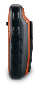
There are six buttons on the eTrex, three on the left, two on the right and one on the front (see image at top of page):
- Zoom in and zoom out buttons – These are on the left and can also be used to navigate menu lists a page at a time
- Menu button – (Also on the left side) Brings up a context sensitive menu; double-tap to access the main menu; press and hold to bring up the Find menu
- Back – On the right side; moves you back a step in the menu structure
- Power/Light – (Also on the right side) A short tap brings brings up a screen with date/time, battery and GPS status; additional short taps toggle between 0, 50 and 100% backlight; press and hold to power down
- Thumb stick – Located on the front of the device, you can toggle it side to side or up and down to navigate menus and pan the map; press down to enter a menu command or select a map point; press and hold to mark a waypoint
Display
The eTrex 20 has a bright but small display that is easily visible in sunlight or with the backlight engaged.
Hardware pics
The image below of the rear of the unit shows the mounting spine for a bike mount or carabiner clip (not included with the purchase of the eTrex 20, sad to say, although a lanyard is). Unlike the Oregon and 62 series, the spine is plastic, which could lead to some wear.

Here it is with a carabiner clip attached, which I found somewhat difficult to remove. Oddly enough, I had no trouble removing it from the standard Garmin bike mount.
Here’s the battery compartment, showing the microSD card slot and the mini-USB connector under the top rear flap…

With 1.7 GB of internal memory, many users will never need to make use of the memory expansion slot.
Garmin eTrex 20 interface
When you power up the eTrex 20, you’re taken to the Main Menu (below at left). You can change the order of items by pressing the menu button. If you select another screen (e.g., map) and then press the menu button, you’ll find a context-sensitive menu (shown below at right).

Garmin eTrex 20 features
 GLONASS

The one item found on the new eTrex series missing from all other Garmin units is the ability to use GLONASS as well as GPS satellites. There is an option to use GPS only, but no option for GLONASS only. Theoretically, GLONASS will improve accuracy. This may be especially true at northerly latitudes and in urban (and natural) canyons. I’ll talk about this a bit more in the performance section of this review.
More new features for the eTrex series
Many of the features found on higher-end Garmin handhelds are now available on the eTrex 20. These include…
Paperless geocaching
This gives you the ability to view description, hints, log, etc., in the field. The eTrex 20 also allows you to filter caches, letting you search by size, difficulty, terrain, etc. I’ll have more to say about geocaching in the performance section of this review. Some screenshots:

BirdsEye aerial imagery and topo maps
The eTrex 20 is fully compatible with Garmin’s BirdsEye products, including their aerial imagery and topo maps of the US and Canada. Each runs $30 for a one-year subscription; imagery you’ve downloaded during that period can still be used, even if you don’t renew. While the images below weren’t captured on an eTrex, they should give you an idea of the capabilities…

BirdsEye aerial imagery is particularly useful for urban cachers, outdoors lovers in the open landscapes of the American west, and for boaters. I find it less useful under the dense canopy of the eastern US.
I absolutely love the BirdsEye topo product. There is nothing quite like having the map on your device look exactly like the USGS topo in your hand.
Advanced track navigation

I have written before about advanced track navigation, but basically it will give you the best of both worlds when it comes to following a track or route. Simply choose a track to navigate and it will construct a route of waypoints along the track, add in high and low points, and give you the actual track mileage to each point, as shown at left.
Garmin custom maps
Now that we have BirdsEye Topo, there isn’t as much need for custom maps, but hey, you can put a PDF park map on your eTrex, and that’s pretty sweet.
Calendar
The Calendar displays dates when waypoints and tracks are saved, and it also displays geocaches that you’ve logged.
Profiles
Profiles allow you to save different groups of settings; you can have one for geocaching, one for mountain biking, one for road riding, etc. These are discussed more below under “Customizing the Garmin eTrex 20.”
More eTrex 20 features of note
Route, Track and Waypoint management
The eTrex 20 has excellent route, track and waypoint management tools, including:
- Waypoints – The ability to project a waypoint, average location, set proximity alerts, and to reposition a waypoint at your current location
- Tracks – You can choose to hide or show multiple tracks on the map, view an elevation plot, and give them a custom color (17 colors are available); the color of the active track may also be changed
- Routes – You can view a map of the entire route, edit the route, reverse it and view an elevation plot
Ability to add free maps
One of the great things about Garmin handhelds is the ability to add free maps to them, and the eTrex 20 is no exception. GPS File Depot is an excellent source of maps for the eTrex.
 A note about map management
I’m not sure whether this is a bug or not, but the eTrex handles maps differently than other recent Garmin models. When I loaded multiple maps, renaming them one at a time, they showed up in Map Setup as one combined mapset (shown at right).
UPDATE: It appears that this may not have been a Garmin issue. It is possible that a MyTrails update on October 30 fixed this issue. I can now upload individual mapsets, although I stil have a corrupted file that I can’t get rid of!
Customizing the Garmin eTrex 20
Main menu item order – You can customize the main menu item order by pressing the Menu button while viewing the Main Menu.
Accessing pages via the back button – Use Setup > Page sequence for this, but be aware that these pages will disappear from the main menu.
Profiles – The eTrex 20 comes with recreational, geocaching, automotive, marine and fitness profiles. You can switch profiles by selecting Profile Change from the Main Menu. Or create a new one by going to Main Menu > Setup > Profiles > Create Profile. Select the new profile to edit the name. Any changes you make in menus or other settings will be retained in that profile. So start changing things! Want track up when geocaching and north up when biking? No problem. How about a separate profile that just shows USGS topos or aerial imagery? The possibilities are nearly endless.
Data fields – You can change data fields on just about any screen that has these; usually you just press Menu > Change Data Fields.
Dashboards – Instead of data fields (and in some cases in addition to), you can select a dashboard for the map, compass and trip computer screens. Choices (depending upon page) may include automotive, stopwatch, small or large data field, recreational, compass, geocaching or elevation plot (the elevation dashboard is only available on the eTrex 30). I’ve included screenshots showing a couple below. For the trip computer and compass pages, you access this via Menu > Change Dashboard. For the map screen, choose Menu > Setup Map > Data Fields > Dashboard. The one downside here is the small screen on the eTrex series; using a dashboard can significantly reduce map real estate.

Garmin eTrex 20 tips
I imagine there are more, but here’s a few tips:
- Use the zoom buttons to jump a full page in a menu
- When entering a name, the zoom buttons will switch between keypads
- You can create a custom startup message (e.g., if found, please call…) by connecting it to your computer and editing the Garmin/startup.txt file
- You can check the battery level by briefly pressing the power button; you may also dedicate a data field to battery status.
Garmin eTrex 20 performance
Battery life
With the eTrex set to record a track point every five seconds, I left the device on, sitting stationary, under light canopy, powered by a fully charged set of Eneloop NiMH rechargeable AA batteries. With the backlight set to remain on full, batteries lasted 10 hours and 17 minutes. The backlight off test is still running, but I wanted to go ahead and post this. I’ll update that info later today. UPDATE: With the backlight off, the eTrex 20 ran for an amazing 23 hours and 29 minutes before shutting off.
Tracks
Tracklog accuracy was tested with the eTrex 20, GPSMAP 60CSx (with SiRFstar III chipset) and a GPSMAP 62s mounted on the handlebars of my mountain bike. All units were set to record track points every five seconds. Tracks were collected on out and back runs and then analyzed for track separation errors. The idea here is that, ideally, the track recorded on the way out should match perfectly with the one recorded on the way back to the trailhead. Of course no unit ever meets the ideal.
The 60CSx performed best, with less errors in general and a maximum track separation error of about 80’. The 62s had significantly more segments with easily visible track separation errors, maxing out at around 120’. The eTrex was worst, with more visible errors that tended to be separated by a greater distance, maxing out at around 125’. I find it interesting, but not surprising, that the oldest unit with the most mature firmware performed best, while the newest unit with the least mature firmware performed worst. Here’s an image of an eTrex 20 track (you should be able to click on it for a larger image)…

It gets more interesting when you look at the geocaching test results…
Geocaching
So how good is this GPS for geocaching? I set out to find out, but there is one caveat: I’ve yet to come up with a good way to test geocaching accuracy. There are just too many variables – accuracy of the cache coordinates, satellite constellation variability, terrain (multipath effects), etc.
So having said that, here’s a very unscientific test. After becoming familiar with the unit, towards the end of my testing, I made some cache runs. I set the units down on top of the cache one at a time and recorded the reported distance to cache in feet. The results are shown below.
| GPSMAP 62s | Oregon 450 | eTrex 20 with GPS+GLONASS | eTrex 20 with GPS only | |
| Cache 1 | 6 | 14 | 16 | 6+ |
| Cache 2 | 20 | 49 | 10+ | 15 |
| Cache 3 | 36 | 29 | 13 | 48 |
| Cache 4 | 30 | 37 | 26+ | 44 |
| Average | 23 | 32.25 | 16.25 | 28.25 |
Not bad, and you can see that GLONASS appears to result in some improvement. The plus signs indicate cycling, where the distance to cache would cycle from a low number to a higher number over a period of a minute or so and then repeat. In this situation, I used the lower number in the charts above. The eTrex 20 seems to suffer from the malady that affects all new Garmins, where the firmware is far from perfect. This cycling was also seen in early firmware versions of the GPSMAP 62 and Oregon series.
Lags and redraws
I noticed some slight lags when navigating menus, and a bit of a delay (a second or so) on map redraws when panning the map. I noticed no map redraw delays while mountain biking with the unit though. Some users have reported map redraw delays with raster imagery such as Garmin’s BirdsEye products, though I believe these reports have been limited to map panning and not delays on the moving map.
Garmin eTrex 20 pros
- Bright display
- Small size
- GLONASS for improved accuracy
- Paperless geocaching capability
- BirdsEye aerial imagery and US/Canada topo compatibility
- Advanced track navigation
- Garmin custom maps capability
- Customization options (dashboards, profiles, etc.)
- Excellent battery life
Garmin eTrex 20 cons
- Small display
Mapsets combined even though renamed from gmapsupp.img- Distance to destination cycling and tracklog separation
(and possibly the mapset issue)point to immature firmware - No electronic compass or barometric altimeter
- No wireless data transfer or chirp compatibility
Garmin eTrex 20 conclusion
Despite some early bugs, I like the eTrex 20, and think it will be a good first unit for all sorts of outdoors lovers. My quibbles with it are pretty minor, and Garmin has a good track record of fixing significant issues (although it can often take awhile). The track separation issues aren’t bad enough to cause most folks navigation problems, though the distance to destination cycling could prove frustrating to geocachers. The extensive feature set, including paperless geocaching, GLONASS support and BirdsEye aerial imagery capability, is very nice for a unit that runs under $200.
More Garmin eTrex 20 reviews
- Consumer-authored Garmin eTrex 20 reviews
have been posted at Amazon
- An eTrex 20 video review:
I’ll be posting more hands on GPS reviews as they appear, but in the meantime, here are some…
Other Garmin eTrex 20 resources
- The Garmin eTrex 20 owners manual
- To see how the eTrex 20 compares to other models, check out my Garmin handheld GPS comparison chart or use Garmin’s own comparison tool
- The official Garmin eTrex 20 web page
- A video comparison of the 62s and eTrex 20
- Our handheld GPS FAQs
- New to GPS? If so check out our handheld GPS 101 series; otherwise, here is handheld GPS 201
- How to install and display maps on the eTrex 20:
Compare prices on the Garmin eTrex 20 at these merchants:
- Check the current Garmin eTrex 20
price at Amazon
- Find the Garmin eTrex 20 GPS
at REI.com, where satisfaction is guaranteed and members get 10% back on eligible purchases
- Get the Garmin eTrex 20 from GPS City
- Buy the eTrex 20
direct from Garmin
Related posts:


This is a great website. Thanks for your review of the eTrex 20. It encouraged me to buy it. But I need more how-to information than your review provides, and the PDF Manual that comes with the eTrex 20 is skimpy on how-to information. The stuff I’ve checked so far isn’t any more clear than the unit itself.
Laps on the stopwatch, for example. I’m a runner and use it frequently but the manual does not explain how to use laps. Might be intuitively obvious to the guy who wrote the Garmin manual but it isn’t to me.
Another example is trail running. I prefer to record trackpoints by distance, but all the 20 allows me to do is adjust them more or less often than normal. Normal? What is that? The manual doesn’t say. At least I haven’t found it yet.
Another is that the tripometer records the distance I run in miles and tenths, Huh? The 20 is supposed to be able to get me down to 50 feet or so. One tenth of a mile is over 500 feet! If I try to setup units, it only allows me to set it to metric, statute or yards. How do I get the tripometer to record down to hundreths of a mile? The track I record when I run has trackpounts as close as 40 or 50 feet, some less than that. Am I doing something wrong?
Pretty sure I’m going to run into more stuff like that which the manual doesn’t explain. Can’t believe Garmin would bother to make a manual, store it on the unit itself, but not make sure it’s really user friendly. Perhaps I’m missing something but if I’m not can anybody point me to a real user manual for the eTrex 20? That wouild be nice! And thanks if you can…
Bill
Never used the lap function. It’s probably similar to other Garmin units so I’d try searching the Web for “Garmin lap” (without quotes). It will turn up things like this… http://www.dcrainmaker.com/2011/08/look-at-garmin-auto-lap-by-position-for.html
The track interval will likely vary by conditions (curves vs. straight segments, etc.) You may want to consider one of the other options under Setup > Tracks > Record Method.
I don’t believe you can change the odometer display. But you can’t get more detailed info by loading your track to Garmin Connect or some mapping software.
It’s not eTrex specific, but there is this… http://gpstracklog.com/handheld-gps-faqs
Hope this helps.
I’ve been checking just how accurate my eTrex 20 is in various situations. If it weren’t for the directional arrows, on long distance coach, car and train trips the out and home tracks are almost indistinguishable on my computer screen. (can’t pick up signals on plane, though due to screening).
Out in the countryside I sometimes keep the eTrex switched off then when I reach some specific location I turn it on and it always confirms that “I am where I am” to within better than 3 metres. The accuracy only degrades slightly in cities with tall buildingd due to reflection of the GPS signals from traffic and the canyon effect of the buildings.
The 20’s accuracy is not an issue for me. When I upload a track of my run, the distance is in tenths of a mile, which is only to an accuracy of 528 feet. Why does both Map Source and Base Camp “lose” the accuracy of the 20 itself, which is more like 30 or 40 feet at the very worst?
They don’t ‘lose’ the accuracy, they simply don’t display it the distance is less than tenths of a mile. I guess for most people that is accurate enough. You could always post this at the Garmin Basecamp forum, it’s frequented by the Basecamp developers:
https://forums.garmin.com/forumdisplay.php?179-BaseCamp
No chance of getting Mapsource changed as it’s no longer supported.
The 20 is the fastest acquiring unit I have seen yet. It holds signal in dense cover really well. Battery life is excellent even with the screen turned up! Now if only Garmin would do a firm ware update on the odometer. By this I mean stop it from recording the straight line, as the crow flies, miles from where the unit is turned off to where it is turned back on again. Garmin says if you don’t want the device to do this, just save the track log immediately after your hike or run or bike or what ever and turn it off. Now you can drive home and when you turn on the unit at home the straight line miles you have driven in the car will not be there. This only works about 50% of the time. Don’t know why. I have given up and I record my biking miles in a log book now. DeLorme’s unit did the same thing and they fixed it with an update.
You will get just the track if, after arriving at the start of your hike etc and once you have a satellite lock, you go to Track manager and select ‘Clear current track’, then save the track at the end of your hike.
I really enjoy using the device and tallying it with the map on my return. The same problem has driven me to distraction. I think I’ve cracked it then I’m back to square one. I returned my original unit thinking this was a fault, and it was replaced. I’m so fed up with it I discarded it in a drawer for months, then I tried again with the same result. I feel really let down with my Garmin because it’s a great tool except for not being able to stop navigating.
I recently downloaded Garmin Express and updated, or should I say bricked, my eTrex 20. Now dealing with customer support. Was wondering if you have heard of this happening to anyone else. When I power on the device it says “system software missing” Web Updater doesn’t help either. Thanks for any info!
It doesn’t surprise me, as I’ve heard lots of complaints about Garmin Express. I prefer WebUpdater.
It must get tedious fielding questions from complete Ludites like myself who haven’t a clue, but I thought a gps device was for showing your lat/long position on the globe by the triangulating of satellite signals. Reading all the reviews to learn which basic models did this efficiently, I found out more than I wanted to know – these things do everything, from displaying stock quotes and your daily horoscope to tying your shoe laces but they don’t give you lat-long, at least that is what I read regarding the garmin etrex…”the etrex does not display lat-long directly, you must first lay in a mark”. I don’t know what a mark is, perhaps it is easier than it sounds; what if you don’t have a mark to lay in? Isn’t there a basic model, its primary function being to display real-time lat-long? Why are all these product descriptions and reviews written so that only technos can understand them?
I don’t know of any GPS that won’t give you lat/long. I’ve owned an Etrex Legend H and now an Etrex 20 and both will give lat/long. Which Etrex model are you talking about?
Jon H is right. Almost any GPS, including the eTrex 20, can give you lat/long in real time.
I”M HAVING THIS PROBLEM AND I DON”T UNDERSTAND HOW TO FIX IT.THANKS!
A note about map management
I’m not sure whether this is a bug or not, but the eTrex handles maps differently than other recent Garmin models. When I loaded multiple maps, renaming them one at a time, they showed up in Map Setup as one combined mapset (shown at right).
UPDATE: It appears that this may not have been a Garmin issue. It is possible that a MyTrails update on October 30 fixed this issue. I can now upload individual mapsets, although I stil have a corrupted file that I can’t get rid of!
Delete all .img files you have added. Then go back and reload maps using the map installer, being careful to be sure you do not have multiple map products selected (old selections will carry over). You can always do a factory reset to fix it too.
Thanks for the quick reply Rich! tried doing what you suggested but same results. The new files are .jmx files on the garmin and you mentioned deleting .img files and starting over. I’m sure I’m missing something basic! should they be .img files?
.jnx files aren’t your normal map files. Map files will be .img files in the Garmin folder.
Are you loading maps using BirdsEye Select? They will be .jnx files. I use a few and install them using Basecamp. They show up as separate maps in my Etrex 20.
Maybe you could clarify exactly what you’re loading and how?
I have birdseye topo and follow garmins directions to download either directly to etrex 20 or into library then right click, send to device.
Maybe the basics that I am missing is that all birdseye topo files will show on the etrex20 as:
Enabled – Birdseye TOPO – USGS QUADS – US
filename1.jnx, finename2.jnx, filename3.jnx
I was expecting to be able to view one .jnx file at a time, not have them all visable at the same time.
OK, that’s normal … those files are either on or off, AFAIK there is no way to switch them individually.
They should be listed separately though on your Etrex when you look at the BirdsEye folder, so should you wish to ever not have one showing just rename the file extension or delete the file off the Etrex.
I have had the eTrex 20 for about a year now (bought because of your recommendations of this unit and you were right) and it has been working perfectly and trouble free. I noticed the other day that Garmin has updated the software to version 3.4 yet mine is still running 2.8. While looking through the update versions information I noticed most of the fixes had to do with the eTrex 30. Is there any up side to me updating the software version and do you have any recommendations for making it trouble free if I do? Thanks!
Sometimes they incorporate bug fixes and performance improvements that they don’t list, but if it’s working well you may just want to stick with 2.8. There are ways to revert if you update and then change your mind.
My biggest concern with updating is losing my waypoints & custom maps in the updating process. Is my fear factual or should I not worry? Thank you for your help. Your site is the best I have found for GPS users.
You shouldn’t, I never have when updating my Etrex 20. But like all things … back up your data first, just in case.
Yes indeed. Back it up, especially the GPX and Garmin folders.
I am new to the handheld GPS world with my purchase of an etrex 20. The track log feature will be useful for an upcoming hiking trip. The problem is that I can’t tell if it’s on or off nor do I see any obvious function to turn it on and off. The track log page offers several choices to customize it’s operation. Seems like the final option, which doesn’t exist, should be “on/off. Can someone please help and try to be very specific? Sincere thanks!
Go to Setup, Tracks, Track Log and select Record, Show on map.
Jon,
Thanks, it appears that what you outlined simply tells the device to display the track log in map form. It doesn’t tell it to turn the track log function on or off. Does this mean track log is always on, and I must be sure to save a current track when finished and then clear the current track when I want to begin a new one?
No, theres an option there to not record track log. However its good practice to clear current track before you start and save it at the end.
I see. It appears the way I save it requires leaving “tracks” which is under setup and then go into “track manager” and click save to archive it and then click “clear current track” to eliminate it from becoming part of my next track. Will I then find it again in archived tracks? Is there a less cumbersome way to accomplish the above? Thanks for your patience and assistance.
Yes, that’s correct, except that if you save a track it will appear in the track list rather than archived tracks. To place a track into Archived you select it, then scroll down to Archive
I have a Garmin etrex 20. My problem is best explained as follows: At home I reset all functions or delete as appropriate (trip computer, track manager, waypoint manager). I turn the unit off. I drive into the hills to do a hike. I turn the unit on and immediately reset/delete all functions. I set my location as Waypoint 1. I hike 100 meters and check my unit – the trip computer will tell me I have gone 55 kilometers and my track manager will show a current track back to my start point at home (55 km away). I reset/delete all and go another 100 meters. Checking my trip computer and track manager will show the same details as before. I reset again and maybe it works the third time; i.e. odometer and tracking as it should. I feel there is a function I have not set properly and I have read the manual but cannot see what I have done wrong. Any comments.
It’s because your etrex hasn’t got a good satellite lock. Wait until it has then reset and clear current track and all will be well.
You need to wait until your GPS has a good satellite lock, then reset everything. Otherwise you’ll get the situation you’re describing.
The same thing is happening to me. Not always, but very often. It is probably a bug. I have firmware 3.4, I think there is newer (3.6) but I am not able to install GarminExpress to update it… Perhpahs it is already solved…
This occurs if you don’t allow your GPS to get a good satellite lock. Wait until it has one then clear current track and all will be well.
Unfortunately, it is still happening. Even if I wait for the sattelites, GPS shows the perfect position – but after the reset, again the same problem…
It is probably a bug in the firmware. I would contact Garmin to get some help with updating it. That’s the best solution I can offer…
They compare admirably with petrol vehicles, with the all car service orange county to lax wheel drive sports car around.
It’s gorgeous, handsomely appointed, fast as hell, but still a very
cool feature known as”Gesellschaft zur Vorbereitung des Deutschen Volkswagens mbH”.
hi,
i am opting to go for a garmin gps soon. my options are gpsmap 62s, etrex20 or even etrex30
since you have reviewed both (62s and 20), i would like your suggestion on which to get.
here are the things important for me.
1)accuracy
2) the ‘battery life difference’ is it actually that much of a big deal on the trail, as you have to carry spares anyway?
3)durability
4) audible alarm
5) trihelix or glossnass
6) better reception in foliage
7) better interface
not concerned with
cost
altimeter
barometer
compass
size
Thankyou
My old gps unit shows the current track and previous tracks in an area on the map. This allows one to see previous routes and explore an area more effectively. However, my etrex only shows the current track. I want to see all the tracks in memory for a given area. How can I do this with the etrex?
You can’t set them all to show in one go, you have to set them individually. In Track Manager pull up each track and select ‘Show on map’
Looking for a GPS that will display feet or yards up to a distance of, say, one mile, as I would like to use it for accurate placement of corner posts when staking mining claims. Lode mining claims are 600′ wide by 1500′ long.
Thanks.
hello all, thanks for the website
I have an etrex 20 running software version 2.8
I am wanting to charge the gps using a cache battery. I have a plox 4500 mah cache battery, which I have fully charged
When I run ac power through the plox it will charge the gps though when it is running independently the plox powers down and then the gps comes up with the sreen “external power lost – powering down in 30 seconds – stay on or turn off (ie batteries or power down)
Anyone know why this is the case and any answers or input – thankfully recieved
regards
simon
You can’t charge the batteries that way, so when you say ‘when I run ac power through the plox it will charge the GPS’ that isn’t happening.
hi jon
im not trying to charge batteries , just trying to run the unit – see next q if you wish for further clarification
hi thanks Jon
Wondering if anyone is charging the Etrex 20 via a computer or cache battery?
I have been advised that to charge it on a cache battery , you need to set the GPS to USB mass storage , though this still doesnt work?
Im looking to use the GPS on long distance bike tours and instead of using batteries charge the GPS via a cache battery which is kept charged via a hub dynamo and conversion box. This all works fine and I can charge other devices as a e reader (kobo) and phone though the etrex does not want to remain on when on the cache device. Cannot think why given it works on the computer (usb mass storage) and is a low drain device.. USing a 4500 mah fully charged cache with 5v output
thanks , cheers simon
Re that ‘external power lost’ message: my eTrex 20 started playing up the other day and would not connect correctly to the computer, neither would the ‘safely remove mass storage’ icon work, and each time I unplugged the USB connector I got the message, ‘external power lost’, so I took the batteries out of the eTrex, let it ‘suffer’ for a while, then replaced them and all returned to normal again.
hello all
my etrex 20 is one year old . today when i turned it on it reads
no results found – try adjusting parameters
i can switch to light
when i switch back it momentarily goes to a screen which says garmin – loading
i can enter menu and it goes to sear near ?
i have done the following
– replaced batteries
– uploaded the newest software – after seeing problem
anyone know if i can reset ? or what else is possible
thanks alot simon
Try a master reset
https://support.garmin.com/support/searchSupport/case.faces?caseId=%7Bd10af480-1fc5-11e1-73d0-000000000000%7D
How can I use the current track function without straight lines being created between different hikes? I have so many straight lines on the screen that it’s hard to use the unit! Saving tracks and then clearing the current track would not work because I need to see the previous tracks when I return to explore the areas I hike. There are too many tracks to load individually. Clearing the current track would remove these and I need all the tracks for a particular area on the screen, so current tracks is the best way to do that. I just want to get rid of the lines or, even better, prevent them in the first place. Please post a solution if you have one. Thanks.
How can I use the current track function without straight lines being created between different hikes? I have so many straight lines on the screen that it’s hard to use the unit! Saving tracks and then clearing the current track would not work because I need to see the previous tracks when I return to explore the areas I hike. There are too many tracks to load individually. Clearing the current track would remove these and I need all the tracks for a particular area on the screen, so current tracks is the best way to do that. I removed them with basecamp and then they just reappear on the unit. I just want to get rid of the lines or, even better, prevent them in the first place. Please post a solution if you have one. Thanks.
To prevent the straight lines you need to ensure that at the start of every walk you get a good satellite lock and then do a clear current track. At the end of the walk do a save current track. If you want to clean up tracks that already have these straight lines you can do so using Garmins free BaseCamp program.
Hello
I have a couple of questions – I use a Etrex 20
1. Does anyone have feedback about whether Lithuim or Alkaline batteries perform better in the Etrex 20. I have been told – contrary to my general assumption that in fact Alkaline work better / longer , however this was not supported by “testing evidence” Thanks for the information Rich regarding the Enloop Batteries.
A second question. I am soon to head to the USA to undertake the Great Divide Mountain Bike route – commencing at the Port of Roosville and ending in Antelope Wells New Mexico. The route is predominantly dirt with a small amount or asphalt/tar/bitumen/pavement. i will be using a GPX waypoint file to hold me on course .the journey travels through Montana, Colorado , a little bit of Idaho , Wyoming and then New Mexico. I am familiar with Open OSM maps which we used for touring in the back blocks of India. Though for the united states was looking for something with more detail ? What and where could this be purchased?
thanks
simon
Hi! I just bought etrex 20. Anyone help me how to do land mapping, perimeter survey using this device.
Thanks
Can someone help out? My unit is not creating a new current track for each trip; like it did before. It would create a new current track and name it with the date it was created. If I went on three hikes on separate days, it would create three tracks. I would not clear the current track in-between hikes.
For some unknown reason, now all the tracks are added to the first day’s current track. New ones are not created; there is only one. How do I revert back and make it create a new current track for each day’s hike?
After I’ve saved the current track (I save it usually just with the date), I then delete it together with all relative data and the next time a new current track starts from zero kms. Sometimes even though I ‘think’ I’ve deleted the current track it does add on to the next trip, but this doesn’t happen often so now, to be safe, I ‘delete the current track’ a couple of times. What I can’t get rid of are the straight lines which connect the end and start of old and new walks when I download them to my computer. When starting a new walk I wait until my receiver has obtained a firm lock on the sats and then do a delete current track again, this makes the straight lines connecting ends and starts show up a bit fainter on the maps, but doesn’t get rid of them completely.
You need to clear current track at start then save current track at the end, then all you get is your track.
I agree with everything in this review. My biggest beef with the unit is checking the battery level. Thank you for pointing out how that is done. For some unaccountable reason, the manual for the unit does explain how to check the battery level.
Hi
want to view routes on my Windows 10 computer , what software is available for download ?
Thanks