The Garmin Montana 650t is one of three models in Garmin’s newest handheld series. With it’s huge 4” touchscreen, I had initially thought the Montanas were targeted to the motorized crowd (ATV’s, etc.), but after spending over a month with one, I’m convinced that a lot of hikers and geocachers will be attracted to it as well. Before we get into the details, here’s some info on the rest of the series…
Related units
- Drop down to the 650 and you’ll lose the 650t’s preloaded 100k scale topo maps
- Further down the line, the 600 drops the 650 and 650t’s 5MP geotagging camera
- Note that all three Montana models have a tri-axial electronic compass and barometric altimeter
- To see how the Montanas stack up against other models, check out our Garmin handheld GPS comparison chart
About those maps
I do not recommend paying the extra for the 650t; I suggest getting the Montana 650 instead. The 650t includes preloaded 100K scale topos, but you can get much more detailed 24K scale topos for free at GPS File Depot. The 650t might make sense if you tend to travel around the US a lot though.
NOTE: Much of the following is taken from my hands on review of the Montana 600.
Garmin Montana 650t hardware
Display
The Montana’s 4” display, and the features that the expanded screen real estate allows, are some of the prime factors making this an attractive device. The screen is recessed, giving it an extra bit of protection. BTW, that 4” display offers almost twice the viewing area of the Oregon series (45.19 sq. cm. vs. 23.94 sq. cm.), and more than twice that of the 62 series (19.8 sq. cm.)
Visibility is better than the Garmin Oregon x50 series, thanks to a slightly lower resolution screen (relative to screen size; 2889 pixels per sq. cm. vs. 4010 pixels/sq. cm. for the Oregon series), which means significantly more light can be reflected back to Montana users. Personally, I don’t find it to be a huge difference, but it is still another incremental improvement, making it somewhat better than the Oregon 450.
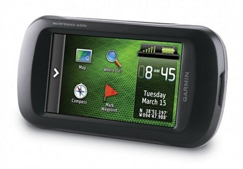
The screen rotates automatically between landscape and portrait views. Interestingly enough, it only rotates three ways, not four. In the image above of another model in the Montana series, it doesn’t matter if the “Montana 650t” text on the body of the device is at the top or bottom in landscape mode, but in portrait mode, the “Garmin” text must be at the bottom; the screen will not rotate 180 degrees from this position. One thing I found as a result of having landscape mode available – I can see all of long waypoint names. Nice!
Screen rotation is generally fast, taking just a second or two as long as the unit is being held at an angle approaching vertical. Hold it horizontally, flip it, and it can take quite a while to figure it out, even if you then incline it vertically. In actuality, this takes some getting used to, since many users tend to hold the device at an angle closer to horizontal than vertical.
Camera
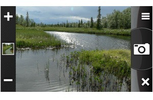
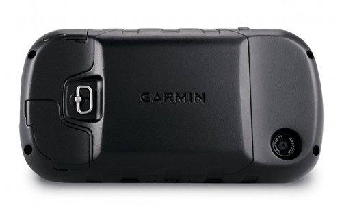
While I did not test a model with a camera (the 650 and 650t have this; I tested the 600), I have included a picture of the camera screen and one showing the rear of the unit with the camera lens below.
Dual-use
When combined with a Garmin mount that features an external speaker, and City Navigator maps, the Montana can deliver spoken turn-by-turn directions, calling out street names. I have yet to pony up for that combo (though I do plan to test it in the near future), but I have been using the Montana with Garmin’s Topo US 24K, which includes routable roads. I only get a beep, but I am getting turn-by-turn directions, using maps that aren’t locked to a single unit.
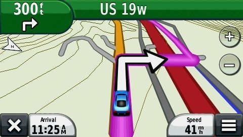
As you can see above, there is a “nuvi” mode, which will definitely give you a very nuvi-like experience. It is a true joy to be able to navigate to a cache or trailhead by car, using your handheld. Gone are the days of having to load waypoints to two units.
UPDATE: Here’s a more in-depth look at setting up the Garmin Montana for highway use.
Interface improvements
Here’s a brief video showing some of the improvements:
I covered the items below in my “first looks” post, so feel free to skip ahead if you’ve read this already.
This is where the Montana really shines. The interface brings the best of both worlds, offering the ease of touchscreen input found on the Oregon series, and the easy access to menu items from the 62 series. But that statement doesn’t do the Montana justice; its access to features is light years ahead of my 62s.
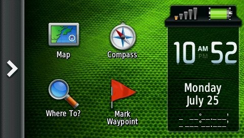
Here’s a look at the Montana’s main menu, which is the screen you’re always greeted with upon startup.
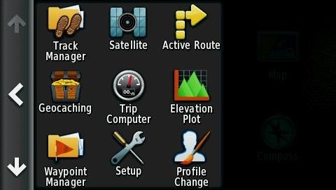
Tap the arrow icon on the right to open the App Drawer.
You can drag apps between the App Drawer and the Main Menu.
If you add more than nine, you’ll lose the names and just have icons. Items in the App Drawer can be rearranged as well.
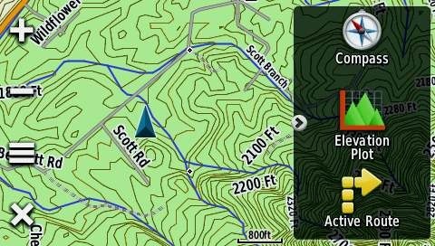
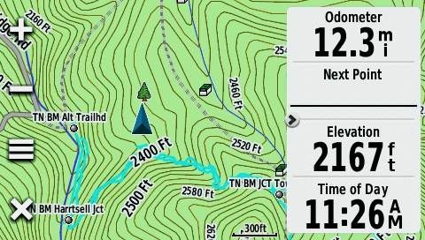
Also new is a Favorites dashboard, shown below. You can have more than three installed; they will scroll within the dashboard.
Note also the arrow icon at the left of the Favorites dashboard above. Tap it to have the dashboard slide out of sight and get a full screen view of the map. Tap the arrow again and the dashboard slides back into view. Nice!
A Shortcuts feature is available from the Setup menu (also from the Favorites dashboard menu). Shortcuts can be added to the Main Menu, App Drawer or Favorites. This feature is a little buggy, with many shortcuts not working. I did manage to place a working shortcut to the display settings on my Favorites dashboard. Once Garmin works the bugs out of shortcuts, you should be able to access just about any feature with a couple of taps.
One of the big improvements is also one of the simplest, the addition of the menu icon (the icon with the three horizontal bars below at left).
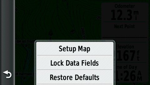
Tap it on the map screen and you’ll see this…
A simple thing, but two less taps than it takes on the Oregon.
Here’s another menu tip.
One other note – you know how you can tap the power button on most Garmins to adjust the backlight, see the signal strength, time of day and battery status? Well you can add a dashboard there as well. My personal favorite is Shortcuts. So now I can tap the power key and get access to a few functions that would push me past nine apps on the home screen – items like Display setup that allows me to enable screen shots. Very nice indeed. Hat tip to Boyd for turning me onto this possibility.
Other recent features
I recently posted five six reasons to buy one of the newer Garmin handhelds, and the Montana series has all of these capabilities. Follow the link above for more details on each:
- Garmin BirdsEye aerial imagery
- Garmin BirdsEye Topo US and Canada
- Garmin custom maps
- Advanced track navigation
- Paperless geocaching
- Profiles
Garmin Montana 650t pros
- Large, bright screen
- Extensive customization options
- Garmin’s best dual-use unit
- 5MP geotagging camera
- Li-ion battery (relatively long life and you don’t have to open the battery cover to recharge)
- Much quicker access to menu items than on Oregon series
- Accurate odometer and tracklog readings
- Screen can be viewed in landscape or portrait orientation
- Easy to hide dashboards to get full screen map view
- Preloaded 100K scale topo maps
Garmin Montana 650t cons
- Relatively bulky and heavy
- Additional maps and mount required to make best highway use of device
- No carabiner clip
Conclusion and recommendation
The Montana series has some great features – a larger and somewhat brighter touchscreen that can rotate between portrait and landscape orientations, an interface that makes it much easier to access settings and switch functions, and a dashboard that can slide out of the way to give you a full screen map view. The ability, at additional cost, to set it up for a nuvi-like highway routing experience is another big plus. I love not having to send trailhead waypoints to another unit.
Garmin has done a pretty good job with this rollout. They were some bugs early on but those are slowly but surely being fixed. In the short time it’s been out, we’ve seen firmware versions 2.60, 2.70, 2.80, 3.00, 3.10 and 3.20.
I’m still not 100% sure what I think of the size of the device, but it really hasn’t seemed too big in my hand. And I’m still waiting on a RAM mount (which is due out any day now) so I can try it on my bike; I’ll be doing a new post on that subject once I’ve tested it.
Most men shouldn’t find the Montana too big; women will smaller hands might be another story, nor is it likely to suit lightweight hikers and backpackers. Yet it should appeal to some other hikers and geocachers, and certainly the motorized crowd (ATVs, snowmobiles, 4WDs, etc.). I guess the clearest statement I can make about size for now is this – if you’re attracted to the feature set, the benefits may well outweigh any concerns about size.
More Garmin Montana 650t reviews
- Consumer-authored Garmin Montana 650t reviews
have been posted at Amazon
- Consumer reviews of the Montana 650t are also being posted at GPS City
- PC World New Zealand gives a 4-1/2 out of 5 star rating in their Montana 650t review
- PC Pro gives a 5 out of 6 sar rating in their Garmin 650t review
- A first impressions review from someone who upgraded from a 60CSx
- A New Zealand-based look at the Montana 650t
I’ll be posting more hands on GPS reviews as they appear, but in the meantime, here are some…
Other Garmin Montana 650t resources
- The Garmin Montana 650t owners manual
- To see how the Montana stacks up against other models, check out our Garmin handheld GPS comparison tool
- A Garmin Montana wiki
- The official Garmin Montana 650t web page
Compare prices on the Garmin Montana 650t at these merchants:
- Check the current Garmin Montana 650t
price at Amazon
- Get a great deal on the Garmin Montana 650t at GPS City
- Check out the deal on the Garmin Montana 650t
at REI.com, where satisfaction is guaranteed and members get 10% back on eligible purchases
- Find the Garmin Montana 650 for a great price at Eastern Mountain Sports


Hi
Have you tried it on your bike?
Which one for MTB? GPSMap 62 or Montana?
Regards
Daniel
Yes…
http://gpstracklog.com/2011/11/garmin-montana-series-ram-mount.html
Tough call. Many of these points still apply…
http://gpstracklog.com/2010/07/garmin-gpsmap-62s-or-oregon-450.html
The main advantage of the 62s is that you can change screens without looking. But the Montana has incredible customization features, a huge screen and works as well as a nuvi once you load City Navigator.
I see your point! 🙂
Thanks for the reply!
Regards
Just one more thing, and in toughness and satellite reception? Equal?
I’ve heard concerns about wear on the button labels on the 62s. And while the Montana has a much bigger screen, it is recessed, whereas the 62s screen is flush.
Generally speaking, reception improves on all these units (with subsequent firmware updates) the longer they’ve been out. Both units exhibited some problems initially, though the Montana’s were minor. The 62s may have a bit of an edge, having been out longer, but I doubt that there is really any significant difference between them. I covered performance near the end of my Montana 600 review BTW…
http://gpstracklog.com/2011/08/garmin-montana-600-review.html
And for FWIW, I’d recommend the 650 over the 650t, unless you travel around the country a lot. The free 24K maps at http://gpsfiledepot.com are much beter than the preloaded 100K maps found on the 650t.
Thanks for the quick reply! 🙂 I have all my country, Portugal, in 24k maps so i can make my own.
Keep up the good work on the great reviews you put up!
Ah, I should check IP addresses before I make a US-assumption! Enjoy whichever you get. And if you get a chance come back and let us know what you think.
Thank you for your excellent review. I owned a Garmin Oregon 400, but saw a 650T on Craigslist that I just couldn’t pass up.
For me, the number one advantage of the 650T is being able to zoom out without losing trails.
As far as being too big? I wore the Oregon on my wrist, and even do so with the 650T. GizzMoVest makes great protective covers for each, and I added a wide velcro strip to them to fasten to my wrist.
I like that I can move and view the screen at the same time, this is very helpful when trying to follow trails that are snow covered.
Thanks and keep up the great work!
How detailed is the marine mapping that comes with the 650t and does it cover the west coast gulf islands area of British Coumbia, Canada. Can more detailed charts be added if necessary and is maps for life available?
Thanks
John
I don’t think there is any marine mapping – just shoreline. These are US topos so it won’t cover Canada either. You can add marine maps, though not all Bluechart features will work on the Montana…
https://buy.garmin.com/shop/shop.do?pID=75228#onTheWater
I *think* you can buy City Navigator and then add a lifetime map subscription for it.
In this case, Probably better for me to buy the 650 (not 650t) and then buy topo Canada and marine blue chart sdcards?
Thanks
John
Yes, I’d say so.
While this FAQ (link) is about the 62/78 series and Bluechart, it probably applies to the Montana as well.
You may also find BirdsEye aerial imagery helpful along the coastline…
http://gpstracklog.com/2011/07/garmin-birdseye-satellite-imagery-2.html
Thanks for the review. I am the proud new owner of a Montana 650t. I just downloaded and installed city navigator maps and a number of opencaching.com caches. I have a RAM mount I used for other devices. RAM mounts work great for me on Motorcycle as well as vehicle, but make sure you get RAM brand and I get the 1″ rubber ball mounts. I also purchased this great case with a RAM mount integrated I got it from amazon and it is made by gizzmovest here is the link http://www.amazon.com/gp/product/B006RY0HVA/ref=wms_ohs_product I am extremely pleased with the quality of the case as well as the GPS.
If you use this mount in a vehicle you can just use the headphone jack to connect to the AUX input on your car stereo, or when I am on my motorcycle I use earbuds and cable extensions.
I was able to go hiking with it already before I had the city maps loaded and the elevation tracking was really cool. I may go for the heart rate and cycle monitor sensors at some point. This unit replaces both my nuvi 765 and an older (1998?) magellan handheld and mounts nice and stable (and waterproof!) to my handlebar on my harley.
So far I give a rating of 4.25. The only issue being the size/weight. Although it does fit nicely in my my hands. For hiking I think the features outweigh the “cost” of the size and weight.
–Doug
Hello Rich,
Please advise me how to save my Montana 650 ‘s Internal Files as a Read-only back-up in my HD.
I have read how to do it at somewhere else . But I couldn’t find it now though I search again.
Thanks in advance.
sai
You just attach it to your computer and copy everything over, but you need to be sure you get any hidden files. Basically it’s the same as a nuvi, see the third post here…
http://forums.gpsreview.net/viewtopic.php?t=21019
Hi,
A Question re using the 600 series as a NUVI device. Can you find, for example, a store/business from database -or type of store with phone number and address if you install the NUVI map/software?
Thanks,
Jay
Yes. It can do this if you load City Navigator maps or Garmin’s newer 24K topo series.
Just showing from what information I have been reading up on the 650t, it is fully compatible with Bluechart G2 maps. You can get one that encompasses the entire lower 48 and the entire west coast up to Alaska mostly for ocean, and great lakes from what I can see though. Also you can get a Canada one which covers the great lakes and East into Canada. Lake Master chips for lakes, and also it does come with a little carabiner clip(Just saying). Just not a carabiner lol. It certainly isn’t all that different from the 650 you hit it on the head, but I got it for a steal, $445 bucks on sale at gander. Chips brand new on sale at Amazon way cheaper then everyone else for the most part. Saw one page with the same 72.50 for topo 24k northern plains, but had shipping charges as well so Amazon is the smart choice.