UPDATE: This product has been discontinued. Read my review of Garmin’s new nationwide Topo US 24K maps.
One of the frustrating things about backcountry use of GPS is having to live with "as the crow flies" routing. That’s not so bad when you’re off-trail, but on trail, I’d prefer my GPS tell me that its five trail miles to the destination rather than three "as the crow flies" miles. The crow can fly, but I can’t.
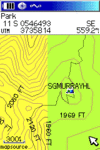
On one of my last outings, I had a chance to try out Garmin’s US TOPO 24K which shows contour intervals closer to USGS 1:24,000 scale maps than their USA TOPO (1:100K) product, hence the name. During one outing, I happened to be on the dividing line between these two coverages, as captured in the screen shot to the left.
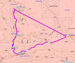
Clearly, this enhanced level of detail is desirable, but having routable trails excites me just as much. I couldn’t trick my GPS into capturing a screen shot of a route,  but the image to the right comes from the MapSource desktop. You can see that the software routed along the highway and a trail, but that it had to do "line of sight" routing where one trail was not on the map. It was really nice to know just how far I had to go to the next junction.
The formal name of this product is US TOPO 24K – National Parks, and you can purchase it for the eastern, central or western U.S. But as I discovered on this trip, it covers more than just national parks. The images shown here were not captured in national parks, but in the San Bernardino National Forest.
You can go to Garmin’s coverage map for the east, central and west package to see what areas are covered, and to see which Garmin receivers are compatible with this software. For a detailed look, check out Garmin’s MapSource Map Viewer, which allows you to see exactly what will appear on your GPS screen for any given area, for any of their products.
Find the best prices on Garmin US Topo 24K at these merchants:

This article implies that Garmin has a whole 24k US Topo, and that it’s routable. But as you mention barely, and as an afterthought, the product is for National Parks, east, mid, and west, and you say it covers more than just National Parks, but not MUCH more. Whether it’s routable or not, I can’t speak on.
Update: they now do have a whole USA 24k Topo product, but it’s only available on an SD card, and not on a DVD, which means that you can’t load it into Mapsouce, and if you own the CityNav or their 100k topos, or have couple of the spectacular free 24k topos out there, you’re outta luck if you want them all at the same time, because you can’t transfer the maps from the card to your computer, and if something happens to the SD card, which is easy for something that small and delicate, you’re outta luck!
Hey Duke. I just moved back east after ten years in Mendocino County!
BTW, the new 24K regional topos have City Nav data built into them.
?? ??? ?? ??? ??? ???? ??
?? ? ???? ?? ?? ? ??? ??? ??? ??? ?? ??? ??? ???.
?? ???? ?? ?? ??? ???.
???? ????? ??? ????? ?? ??????,
??? ??? ?? ??? ??? ?? ?? ???? ??? ??.
??:???? ?????!
I have the Garmin GPSmap60csx and Topo24K Northwest. Can anyone tell me how to use the routable trails feature? I’ve tried on several trails and can’t make it work. Always calculates an “as the crow flies” route. Thanks!
Ryan
Try Main Menu > Setup > Routing and under Guidance Method, select Prompted or Follow Road.