My posting frequency has been down a bit lately, as I just returned from a “working vacation” – how’s that for an oxymoron? Nevertheless, my wife and I had fun exploring New Mexico and a bit of Colorado, but our outdoor adventures were mostly in Southern New Mexico. I like describing and posting tracks of our hikes and bike rides (and how I prepped our GPS receivers for them), so if it’s your cup of tea, read on. If not, regular programming will return following this post!
My wife (who is also my partner in outdoor adventure) is five months pregnant, so this won’t be a report of crazy adventures, filled with mountain bike crashes and off-trail adventures in canyons. This trip was comprised of relatively sedate hikes. In addition to those listed below, we also did shorter jaunts in Petroglyph National Monument (Albuquerque, NM) and Garden of the Gods (Colorado Springs, CO), but the tracks there aren’t long enough to be of much use to anyone. So without further delay…
Trip preparation
I had very little time for trip planning, but here’s what I did. I grabbed a few guide books from the library, noting interesting trails that were within the realm of what we wanted to tackle. Once I had some trail names, I used my GPS data search tool to look for waypoints and tracks. Unfortunately, I only found data for one of the planned hikes, but that led me to a track on National Geographic TOPO!’s MapXchange. I don’t have the New Mexico TOPO discs, so I used GPS Babel to convert it to a .gpx track.
I’m currently doing some extended testing of a DeLorme PN-20, and I have Topo USA 6.0, so I used that to print maps of the hikes. I included trailheads and other key waypoints, along with the one track I was able to download. I transferred that track to our GPS receivers as well, in order to display the trail.
Baylor Pass
Baylor Pass is located in the Aguirre Springs National Recreation Area, just east
of Las Cruces, New Mexico. This hike was 4.57 miles long and, according to my Garmin 60CSx, we did over 1800 feet in elevation gain. That was a bit of a surprise since the trail descriptions I saw said 760 feet of gain. Of course, any of you who have been doing this for long know what happened. The trail description cited the overall change in elevation, from low point to high, while the Garmin recorded all the ups and downs. I’ve found my Garmin’s barometric altimeter to be very accurate on bike rides, but I wonder if the slower pace of a hike may have led to some exaggerated readings. Regardless, there were some ups and downs, so I don’t think it was off by that much.
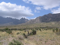
Highlights of this hike were outstanding views of the Organ Mountains (above), a rattlesnake on the approach road, cacti in bloom and near gale force winds at the pass!

Gomez Peak
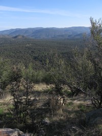
Originally, we were going to do the Catwalk, but our plans changed and we opted for something much closer to Silver City, New Mexico, where we were staying. Located just inside the Gila National Forest, this is a jewel of a trail a few short minutes from town. It was probably the most enjoyable hike of the trip, perhaps due to the near-dawn departure. I can’t quite finger anything exceptional about the hike really, though I always enjoy peak bagging and the views that go with it. The accompanying photo shows the view from the peak into the Gila National Forest to the north.
A sign at the trailhead mentioned that Mexican Gray Wolves had been reintroduced into the area as part of an Endangered Species Act recovery plan. On the trail we ran into someone who told us they were being threatened by control efforts managed by the NM Department of Game and Fish. She urged us to stop in town later where an information / letter writing station was being set up. The station was managed by Michael Robinson of the Center for Biological Diversity (CBD). An email update I received from Michael this morning said in part…
"The federal government is flying over the Gila Wilderness this week and next, trying to shoot the alpha male of the Saddle Pack of Mexican gray wolves. He’s wearing a radio collar, no escape from the eye-in-the-sky, but he was nearby when a younger pack-mate was gunned down from the air last month. Will he know to stay out of open areas, to run for a forested canyon at the first sound of a distant engine?"
If you want to help, follow this CBD link to learn more about protecting the Mexican Gray Wolf.
