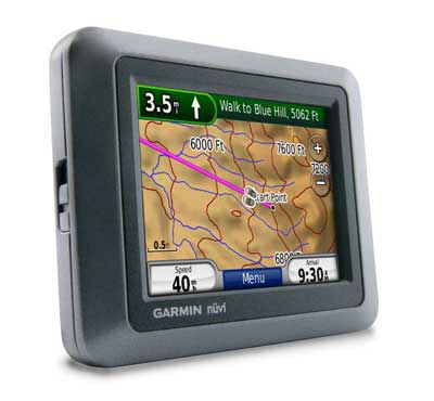
Hands on with the Garmin nuvi 500
The Garmin nuvi 500 represents Garmin’s foray into the “crossover” GPS market, aiming for a device that functions well whether used for driving, hiking, cycling or boating. This review will take a hard look at how well Garmin pulls that off, but first let’s get some basics out of the way.
UPDATE: Here’s a post I did about dual-use GPS, and how well they work for both road and trail.
The 3.5″ touch-screen nuvi 500 comes pre-loaded with City Navigator and topo maps of the 48 contiguous United States, Hawaii and Puerto Rico. The other model in this series, the Garmin nuvi 550, offers highway coverage of the entire U.S. and Canada but drops the topo maps. Neither unit has text-to-speech, so you’ll hear “drive one-half mile, then turn left” instead of “drive one-half mile, then turn left on Main Street.”
Compare prices on the Garmin nuvi 500
There are some other nice features found on the nuvi 500 series though. Based on the nuvi 2×5 platform, the nuvi 500 offers:
- A redesigned map screen with an extra data field showing your current speed
- Speed limit display
- Tracklog display
- Recent cities and streets can be accessed from search screens
- Where am I?
- Photo navigation
- Terrain modeling
- MSN Direct or FM/TMC traffic (optional)
You can read about these features in more detail in my Garmin nuvi 205W review.
There are also a couple of features found on the 500 and 550 that are not present on the 2×5 series nuvis — multi-destination routing and a removable, li-ion battery rated at up to 8 hours.
Garmin nuvi 500 usage mode
From the main menu, tap the icon in the center of the top bar (the walking icon is shown in the image below).
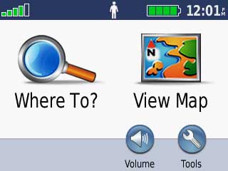
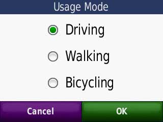
This brings up the screen below, allowing you to select the usage mode. Note that boating is not listed as an option unless you have a BlueChart® g2 or g2 VisionTM map loaded.
Unless you check “don’t ask me again,” you’ll first see the following screen overlay.
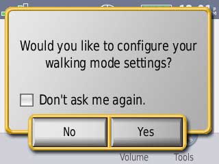
If you change modes often, you may want to leave this box unchecked, as it will bring up options to select your map view and routing preferences.The options presented are as follows:
- Driving -Chose driving vehicle icon, map view (track up, north up or 3D), driving route preference (faster time, shorter distance or off road)
- Walking – Choose walking vehicle (defaults to boots), map view (track up, north up or 3D), route preference (on road or off road)
- Bicycling – Choose bicycling vehicle icon (defaults to bike), map view (track up, north up or 3D), route preference (on road or off road)
Garmin nuvi 500 driving mode
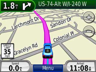
The nuvi 500 series has lost none of its automotive prowess; it performs just as well on the road as any nuvi with comparable features. As a result, I’m going to focus this review on it’s uses for non-automotive pursuits — geocaching, hiking, etc.
Garmin nuvi 500 as a handheld
With any “crossover” GPS receiver, compromises must be made, and it appears that Garmin made them all on the handheld side of the equation. First, what they got right…
The unit appears to be well designed in terms of being waterproof. Battery life also seems good; it is rated at 8 hours. If you need more than that, it has a user-replaceable battery so you can always buy and carry a spare.
But there are more problems than not. Let’s start with the hardware. There is no lanyard attachment, and the unit is awkward to hold. It is pocket-sized, but there is no touch screen lock as there is with the Oregon series. The case seems a little fragile; I’d hate to drop it on a rock, and I definitely wouldn’t put it on a mountain bike.
Worse still, some basic handheld functionality is missing. While the 500 will display your track, and can “TracBack,” you cannot load even one track to the device. Nor can you reposition waypoints to your current location; not as important as loading tracks, but a pet peeve of mine.
Also note that you cannot change the interval or method for recording track points. The nuvi 500 records a relatively low number of track points when compared to other handhelds. It starts a new track segment when you change modes, or even if you search for a waypoint. Not only that, but it leaves a gap of up to several hundred feet in the tracklog when it does so.
Garmin nuvi 500 compass
The nuvi 500 does not have an electronic compass. It uses GPS signals to ascertain your direction, so you must be moving to get an accurate reading (that’s because the unit has no way of ascertaining which way you are facing if standing still).
That’s not so bad, but the manual says “…you must have a clear view of the sky” to navigate with the compass, and I’ve found that to be all too true. When under canopy, the compass is very slow to respond to a change in direction, sometimes taking 500 feet or more at walking speeds.
This is puzzling, because the distance to the destination was fairly accurate, steadily getting smaller even as the compass was telling me to go the opposite way at times. To further muddy the waters, comparing the track of the nuvi 500 to my 60CSx and aerial photos, the nuvi did very well, occasionally showing some error, but never more than 60 feet.
I’m left to conclude that the inability of the compass to guide under even light canopy may be more of a software issue than a problem with the antenna and/or chipset.
Perhaps this will be improved in a future firmware release, along with another compass / off-road navigation issue; the “Arrive in ____ ft” field below is
always blank.
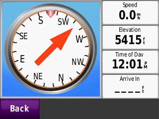
Until they get this fixed, the compass screen is largely useless. Fortunately, the map screen, when routing off road, shows the distance to next and direction in the upper left corner, as shown below. Tapping this field takes you to the compass.
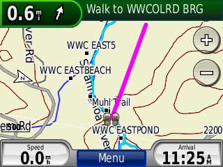
The arrow in this field doesn’t point you in the direction of your destination any better than the compass, but seeing the distance to your goal certainly helps.
That is if you’re within 500 feet of the destination. Above that, it only displays the distance in tenths of a mile, meaning you could walk 500 feet before figuring out that you’re going the wrong way!
According to the manual (which is less than clear), the compass is supposed to function as a course pointer in off-road mode. Therefore, it should indicate your relationship to a course line to your destination, rather than acting as a bearing compass, showing the direction to your destination. The image below is taken from the manual, which states, “when the red arrow points at the bug indicator, you are going directly to your destination.”
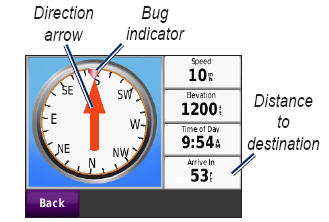
Despite this, in my field tests, the direction arrow seemed to point towards the destination, as if it were functioning in bearing mode. A call to Garmin tech support indicated that the manual may be in error. Note that there is no user setting allowing you to switch between bearing and course mode.
I cannot recommend using this device in the backcountry until the myriad compass issues are resolved. I found it very difficult to rely upon the nuvi 500 for off-road navigation.
Finally, if my notes on the compass are a little confusing, just know that it parallels the experience of using it!
Geocaching with the nuvi 500
Like the Colorado and Oregon models, the nuvi 500 series fully supports paperless geocaching, displaying the full description, cache size, difficulty and terrain ratings, as well as recent logs. Caches can be transferred directly from geocaching.com using the Garmin Communicator plugin or pocket queries can be dropped into the Garmin / GPX directory on the unit. You must be a premium member of geocaching.com ($3/month) to run pocket queries or transfer
the full information to the unit. Screen shots follow.
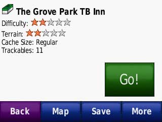
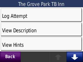
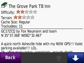

Paperless caching is great, but it’s not quite ready for prime-time on the nuvi 500, thanks to the compass problems mentioned above. Out of six cache attempts, I only found one without resorting to pulling out my 60Csx, which often as not I did just out of sheer frustration with the nuvi. The unit is pretty useless for finding caches unless they are right on the trail. It is definitely not a unit for someone just starting in the sport! Having said that, it could be a great geocaching unit once the compass is fixed.
Garmin nuvi 500 tips
- Quickly tap the power button to bring up an option to change the screen brightness; this is a nice way to prolong battery life when you leave your car to use the device as a handheld
- Hold the lower right corner of the screen while powering on the device to bring up a hard reset option (erases all user data)
- After you transfer routes from MapSource, select Tools > My Data > Import Route From File
Conclusion and recommendation
There is something very attractive about having one device for multiple uses. I have to say that I really like being able to load all waypoints to one unit, use it to drive to the trailhead and then use it for a hike. But many compromises must be made with this type of unit, and as I said earlier, Garmin appears to have made them all on the handheld side. They left all the nuvi auto functionality in, but seemingly did the minimum on the handheld side, without adequately testing it as well. It’s almost as if they didn’t even talk to their handheld folks in developing it.
Until the compass issues are straightened out, I cannot recommend this unit for geocachers, hikers or mountain bikers. Where you will be sticking to roads (road biking), or moving faster (4WDs and ATVs), it may be worth considering.
If you are seriously looking at a “crossover” type unit, you should consider a couple of things:
- What is your primary use going to be? Would you rather compromise on the auto or handheld side?
- Rather than spend $400 or $500 on this unit, you may be better off with a low end nuvi (like the 200 or 205
) for your car, and a basic (Venture HC) to mid-range (60Cx) handheld.
While Garmin may fix the compass functionality, the future might not bring many more improvements for the nuvi 500 series. Garmin seems determined to keep the nuvi platform simple, and I doubt that they will add the ability to load tracks, or any advanced handheld functionality. With luck though, they’ll use it as a learning experience for a new line in the future.
More Garmin nuvi 500 reviews
- The first consumer-authored Garmin nuvi 500 review has been posted at GPS Now.
- PC Magazine gave a 3 out of 5 star rating in their Garmin nuvi 500 review
- CNet also gave a 3 out of 5 star rating in their review of the nuvi 500
- There is a Garmin nuvi 500 review thread at GpsPasSion
- GPS Magazine has posted a Garmin nuvi 500 review based on a pre-production unit
- The Changelog reviews the Garmin nuvi 500
- A user review of the nuvi 500 has been posted at Singletracks.com
- A motorcyclist reviews the nuvi 500
I’ll be posting more hands on GPS reviews as they appear, but in the meantime, here are some…
Other Garmin nuvi 500 resources
- A PDF version of the Garmin nuvi 500 owners manual
- Confused about so many models and choices? Use this Garmin nuvi comparison tool or check out my own Garmin nuvi comparison chart.
- The official Garmin nuvi 500 web page.
- There is a dedicated Garmin nuvi message forum at GpsPasSion.
- And another nuvi forum at GPS Review
- How to access archived nuvi trip logs
- Five tips for nuvi newbies
- Yes, it really does appear to be waterproof:
Compare prices on the Garmin nuvi 500 at these merchants:
- Find the low price on a Garmin nuvi 500 at GPS Now, where shipping is free on orders over $99 (and the upgrade to overnight shipping is dirt cheap!); order by 5 p.m. Central Time for same day shipment
- Check the current Garmin nuvi 500
price at Amazon
- Get the
Garmin nuvi 500 Portable Multifunction GPS Receiver with U.S. Road & Topo Maps
at TigerGPS, where you get free shipping on orders above $250
- Find the Garmin nuvi 500 GPS
at REI.com, where satisfaction is guaranteed and members get 10% back on eligible purchases
- Get the Garmin nuvi 500 for an amazing price on eBay
- Check out our GPS deals site for current specials and rebates on a wide range of GPS receivers


Very helpful review–thanks.
I consider myself a typical target of this type of device–I do a lot of stuff outdoors (but am handy with a map, compass, and altimeter), and hate driving while looking at a paper map during the once a month time I go somewhere unfamiliar. In other words, a GPS would be nice to have in both realms (but not critical).
A dedicated road unit like the 205 might be too much for me and something like the Oregon is too expensive for the use I’d get out of it.
So, I wonder what unit you’d recommend that is primarily for backcountry, but could also mount on a dashboard somehow (doesn’t need to be pretty) and at least show a road map and my position (I could live without turn by turn directions)??
Jon,
My first choice would be a 60Cx or 60CSx. A 76 Cx or CSx model would work too and might be cheaper. But you need to add in the cost of a mount and charger, and you may want topo maps. Garmin’s Topo US 2008 is “unlocked” so you can get that on eBay or some such place at a significant discount.
The good news is that there are lots of free maps out there, though ones giving turn-by-turn directions are rare. Check this out…
http://www.gpsfiledepot.com/maps/
If the total cost of a 60 or 76 series unit and accessories is too much, take a look at the eTrex Legend HCx.
In researching this a bit more, I noted that a big issue for backcountry use is the quality of the maps. I saw your review on Garmin’s higher resolution maps covering National Parks / Forests (and these indeed do cover the area I normally hike in–White Mountain National Forest). But some people have said that the Delorme Topo’s have much more detail. Wondered what you thought about the upcoming PN-40 as an all-purpose unit?
I’m heading out the door right now, but I don’t *think* it will do turn-by-turn routing, should that prove desirable. And DeLorme’s road maps (Street Atlas) may not be compatible, but I don’t have time to verify that right now. I could be wrong; check out this thread…
http://forums.groundspeak.com/GC/index.php?showtopic=197213
There seem to be three choices in this category: this model, the Lowrance XOG and Magellan Crossover. I’ve read reviews elsewhere on each and seen, in particular, the Lowrance XOG has the widest range of map choices, including fishing maps, topo maps and aerial photos that can be downloaded to the device. The price for the Lowrance XOG is less than half what Garmin wants for the Nuvi, so what gives? I just don’t get why Garmin is so high!
Usually, Garmin’s quality is a bit higher than these other brands. But the nuvi 500 series has some definite bugs.
Do you care to kitchen furniture?
Could you pick the best grass seeds?
With over 100 species of domestic and hardwood lumber?
Well I have used my new Nuvi 500 a couple of times, and I must say I like it. I’m still working out the kinks of a mount, and ordered another tinned lead power cord. I’m using the 500 on my truck, and on the Polaris ATV when we get to the back country.
The display is easier to see than Magellan 1500.
It’s fairly easy to set waypoints. No real complaints. I have not used the backtrack yet, but your route is shown as a line (in a different color). MapScource is not very good, Magellan has them beat with VantagePoint. VP is easier to use, more intuitive.
They need to add an internal compass, relying on your movement for heading just doesn’t work out very well.
Over all I like it. And will use it for the next several years. Maybe Garmin will finally come out with a real ATV GPS!
I bought TopoFusion from one of the sites you told me about. Great program to make routes in. Excellent choices of Sat. pictures, topo maps, and seamless changing between them. You should get a cut from sending customers their way.
Now if I could just get the Nuvi to see these routes I uploaded, then I would be good to go.
On another note the Trition 1500 just died, and had to be sent back to Magellan.
Thanks for you help.
Yeah, there’s not one program that does it all. For now, I use TopoFusion for trip planning and logging, MapSource to create routes and NG TOPO for printed maps.
I just got an email from Garmin support: The 500 does not work with the current MapSource to upload routes. And they are working to solve the problem.
That is in direct conflict with the manual. The manual clearly states that you just upload and transfer from My Data.
No date or idea when this problem will be solved.
Huh. I wonder if it worked with previous versions, and if you could do a temporary roll back.
From what I am reading between the lines the problem lies with the Nuvi 500 programing. The routes are there, in the correct file, and are the correct file extensions, but the 500 never contained the programing to handle these routes.
That is in direct conflict with the owners manual.
But they tell me the Zumo would handle these routes, and they only cost at least twice as much as the 500!
FYI, the 500 and 550 now have text-to-speech capability. Not sure if it is (or ever will be) an out-of-the-box feature, but it is definitely available as a free software upgrade from the Garmin website.
I forgot my pin number for agarmin nuivi 200 how do I reset it
From Garmin’s web support site:
If you have a Garmin Lock on your nuvi, zumo or StreetPilot c5xx and you have forgotten your 4 digit PIN number you can unlock the device by returning to your Security Location. The Security Location is the location that you set when you first enabled the Garmin Lock on your device. Returning to the Security Location will unlock your device.
If you have forgotten your PIN and Security Location please contact Product Support for assistance. Please note we will require a copy of the receipt and there will be a charge to unlock the device as this issue is not covered by the warranty.
To contact Product Support in your area go to http://www.garmin.com/garmin/cms/site/us/support/supportcontact
The Garmin Nuvi 500’s back opens up and the expended battery can be swapped out with a fresh one. This is a HUGE benefit for anyone using a GPS in any place other than a car. Another nice feature for the urban tourist is that you can download photos from a special web-site and not only see them on the Nuvi it will give directions to where the photo was taken. Cool.
I was looking at your site, interested in getting a road/hiking gps for afghanistan…but i don’t know which one can do that, or where to get/how much the maps would be?
could you offer me suggestions? Im going out to live there and need one..(would like, too, one that mighte feature ‘find me”, that can send out an email/signal with my gps coordinates, in case i need it–do you know about this?)
I suggest a Garmin unit, because there are lots of free maps of Afghanistan. Sources include:
http://gpsfiledepot.com
http://downloads.cloudmade.com
http://mapcenter2.cgpsmapper.com
There is a new DeLorme PN-60w coming out this spring that will have the capability to send messages. Until then, you would need a second unit like the SPOT Satellite Messenger.
Let me know if you have any followup questions.
I’ve been looking all over the web and at your site for a GPS that makes the most sence for me. It will maily be used across 3 different vehicles. My Snowmobile, Boat, and Jeep in the backcountry of Michigan. I was looking for something that had a larger screen that the Etrex line. I was looking at the Oregon series, then stumbled acroos the Nuvi 500. Any thoughts. I’m going crazy with all the choices out there?
Thanks!
Bruce,
I’d go for the Oregon if you can supply external power for each source. Check this out and then let me know if you have follow up questions…
http://gpstracklog.com/2009/04/dual-use-gps-for-road-and-trail.html
Let me add that the Oregon might be better for snowmobiling (ability to load tracks, aerial images, USGS topos), but the nuvi would perhaps be better for the jeep.
Thanks!
I can supply a 12v source for all of my applications.
Do you by chance know what the Operating temperature range for the units are? I’ve looked through the Garmin site with no luck. I snowmobile in sub-zero temperatures (well not all the time), but it happens.
I checked the nuvi 500 and Oregon 400t. Both are rated to -4F (its in the appendix of the manuals). You might also want to ask at http://garminoregon.wikispaces.com/message/list/home. The person running the site uses the Oregon in New England.
I had a Nuvi 265 that worked wonderfully for finding caches. My 500 is awful. I would like to turn off the arrow and just see and follow coordinates to the cache. How do I turn off the compass arrow and just follow the coordinates?
I don’t know about turning off the compass, but you can get to the satellite screen and see coordinates by pressing on the signal strength bars in the top left corner of the main menu for a few seconds. Before you give up on the compass though, do you have the latest firmware?
I recently bought a Nuvi 500, but I am very disappointed with it, to say the least. I found it very slow while driving. I forgot that I went through a turn while the Garmin is still battling to go round the corner. I re-loaded the maps and updated the firmware, but without any success.
George
Do you have this lag all the time? How long is it in seconds or minutes?
Hi Rich,
Yes it is all the time. I would say it is about 15 seconds.
Wolfie
You could back up your favorites and then try a master reset…
https://support.garmin.com/support/searchSupport/case.faces?caseId={e377b090-0fa7-11dd-dc9c-000000000000}
Aargh! Link wrapped. Here’s what it says:
To perform a Master Reset on the nuvi 200, 205, 465, 500, 600, 700, 705, 1100, 1200, 1300, 1400, 1600, 2200, 2300, or 2400 series device:
Note: A master reset will erase all waypoints or Favorites and will restore your unit to the default factory settings. If you would like to back up your Favorites to your computer, you can find instructions to do so here.
Start with the unit OFF and unplugged from power
Touch and hold the lower right corner of the screen with an index finger or the eraser end of a pencil
Continue touching and holding the lower right hand corner of the screen then power the unit ON
Release the power button when the device powers ON
You will see a new message: Do you really want to erase all user data?
Remove your finger from the touchscreen when this message displays
Touch Yes*
The device will automatically reset. Follow the on screen prompts and then place your device in an area with a clear view of the sky until it acquires satellites.
*If the text language on your nuvi is not set to English, touch the button on the right.
Link Referenced In This Article:
https://buy.garmin.com/support/searchSupport/case.htm?caseId={51c35d50-3dbf-11df-e655-000000000000}
Hey,
I did a master reset, but there is no improvement. Maybe I should live with it.
Wolfie
If you recently bought it, it should be under warranty. I’d call Garmin. That’s too long of a delay. Something is wrong.