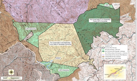
 I learned the other day about a new 10,000 acre tract of public lands near me. There are no trail maps of the area and I am dying to explore it (once all this rain stops). I’ll probably do another post on prepping my GPS for exploring there, but this one aspect warrants its own post.
A quick search turned up a PDF map of the area. This gave me a map of the boundary, but I wanted a way to place that boundary in mapping software where I could create waypoints, layer tracks, and transfer it to my GPS.
It turns out that TopoFusion has a “user calibrated maps” feature. It will only accept .jpg, .png and .bmp files though, so the biggest hurdle was converting the PDF. If you don’t have Photoshop or something similar, you can use a free online converter.
From there it was amazingly easy. One more tip before you get started – it’s best to size the TopoFusion map view as closely as possible to the area covered on the PDF.
If you’re following along with TopoFusion, you can get to this feature by going to Window > User Map Library. Once you add the map, you click on Calibrate Point 1. You can pan and zoom the map as needed. Find a point (I chose a benchmark in the upper left portion of the map) and click on it. The user added map goes away and you can then click the same point on the underlying TopoFusion map. In this case it was a USGS 7.5’ topo. Repeat for points two and three, spreading them apart as much as possible (I try to use points near opposite corners of the map).
With that done, I was able to use the track tool to trace the boundary lines and transfer those to my GPS. You could use this same process to trace trails shown on a PDF park map (though I’d search for actual GPX track files online before taking that route).
I’m sure you’ll be hearing more about how my Rocky Fork trail mapping goes. In the meantime, download the free demo version of TopoFusion and check it out. Get the Pro version, as this feature is not found in the basic version.
Related post:

You can also just take a screen dump of the PDF file, paste it into your favorite photo software (such as Irfanview) and then save the picture as jpg. Or print the PDF file and take a digital picture of it or scan it. I’ve done that even with trail maps carved on a large piece of wood in a park, then used the same procedure you described with Topofusion and I had a trail map on my GPS!
Amit K9CHP
I love the idea of converting a carved, wooden map for use on your GPS. Thanks for sharing!
Conversion from PDF to raster isn’t actually all that difficult. I do it all the time to convert government-published mapping (bedrock geology, surficial geology, etc) into a format our consulting company can use. GSView has been my tried-and-true app for this but I have recently been using PDF-XChange Viewer as a complete replacement for Adobe Reader and discovered that it has a built-in feature (functional even in the free version I’m using) that allows saving of a document into jpg. Another option is to use the latest version of Global Mapper (11), which isn’t free, but allows importing and rectifying of PDF’s directly (including the new GeoPDF format).
Thanks for the tips. Also, unless they’ve changed things, there is a free demo of GlobalMapper.
The free PDF print driver PDFCreator offers the option of “printing” to a graphic image (tiff, jpg, bmp, etc.). So you could open the PDF in Acrobat Reader, then “print” to a graphic file. You can set the output pixel resolution to whatever you want, to preserve the full details. I’ve used this to export the new USGS quads in PDF format to Tiff format.
http://freegeographytools.com/2007/pdfcreator
Also, you can load/calibrate the image, and create a track trace, using the free program OKMap:
http://freegeographytools.com/2008/okmap-gps-mapping-software-for-the-beta-adventurous
It’s improved quite a bit since the review above.
Good stuff. Thanks Leszek (and good luck with the server move).
Acrobat also supports a snapshot tool:
Tools>Select & Zoom>Snapshot Tool . Select the region and the region is copied to the clipboard where you can save it into a photo editor (mspaint works).
Not sure if all PDFs allow this tool to be used but it’s worked for most I’ve dealt with.
-Scott
There’s a free program that I’ve been using quite successfully. Get it here:
http://download.cnet.com/Office-Convert-PDF-to-JPG-JPEG-TIFF-Free/3000-10743_4-10900900.html
Bob
Thanks for the tip!
Raspberry pi and Adruino’s are my favorites.
Thanks for the advice.
Any one know of an app / collection of bodges & tweaks to make it possible to
1. Take an iPhone photo of a trail map as you walk into a national park, ski resort, zoo etc.
2. Then, with ONLY the iPhone, walk to 2 or 3 spots on the map and ‘teach’ the GPS where they are.
3. After that the GPS should be able to follow/locate you anywhere else on the map.
That’s what I am hoping to do – possible?
Thanks
Oh – forgot to mention.
iPhone is jailbroken so any solutions requiring jailbreak only tweaks & apps would work just fine.
Thanks again