I received an email the other day from a reader (Mike) looking for an automotive GPS he could transfer geocaching info to. He asked about doing this via POIs, with a possible goal of getting all U.S. geocaches loaded. I pointed Mike towards some resources and we corresponded a bit more. He ended up buying a Garmin nuvi, and I asked him to keep me posted on his quest. I heard back from Mike today and he’s given me permission to share his experience:
What kind of maps can I put on my GPS (and what do you mean by raster and vector)?
I received a PM from the Adirondack Forum today that said:
"…I just bought the Garmin 60CS. I have a question about the maps. Do I need the Garmin Mapsource United States Topo or… the one from National Geographics Topo that I think is better for hiking? If I don’t buy the Garmin Mapsource Topo, can I download maps in my GPS?…"
This question comes up so often that I felt obligated to post an answer here. The answer is no, you cannot load National Geographic TOPO! maps onto any GPS. You can however, create waypoints and routes with TOPO!, and transfer these to your GPS, but not the maps. Let’s look at why not, and what kind of maps you can load onto your GPS.
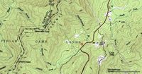
The National Geographic TOPO! maps look just like a paper map from USGS (example above, at right). That’s because they are scanned images, also known as raster imagery. Since they are scans, they have a pretty big file size. That’s why it takes 10 CDs to cover the state of California. And that’s one of the main reasons that GPS manufacturers have taken a different approach.
From the Mailbag
I occassionally get questions directed to my email, so today we inaugurate a new category…from the mailbag. The questions today come to us from Bill Macfarlane, a new geocacher who recently purchased a Magellan eXplorist 500.
"So far I have good luck with it, finding a few caches, but I really think I could be doing more. With this in mind I started to look at Magellan’s other offerings, Mapsend Directroute and Topo 3D, and trying to decide if they were worth the extra. I also have gone through many of the posts on Groundspeak regarding mapping which has added to my confusion…
…While Directroute seems simple enough to understand it usage, the whole sense of 3D mapping and Topo maps in conjunction with the GPSr still seems a mystery to me. Are these programs (Magellan Topo 3D, National Geographic TOPO, OziExplorer…etc) used to help your excursion into the great outdoors? Will they help me find trails that I might not know about in my area or perhaps rank them from a day trip with my Cub Scout group to the extreme hiker? Just where do these programs fit in?"
Read on for my answers…

