 Garmin has announced new pedestrian and public navigation features for their StreetPilot Onboard and Navigon apps, bringing CityXplorer-like features to your smartphone. With the new Urban Guidance (in-app purchase) feature, public transit options will be considered in pedestrian routing decisions, while the Last Mile Navigation feature (Navigon apps only) will automatically mark your location when you park your car.
Garmin mobile apps get CityXplorer features
August 30, 2012 By Leave a Comment
TomTom for Android set for October release
August 29, 2012 By Leave a Comment

EDIT: I’ve added a video after the break.
TomTom has announced that their long-awaited Android app will be released this October. While prices were not announced, we do know that lifetime map updates, text-to-speech, IQ Routes and advanced lane guidance will be included, while HD traffic and speed camera alerts will be available as in-app purchases. read more
TomTom updates their iOS apps
August 21, 2012 By Leave a Comment
 TomTom has updated their iOS navigation apps for all countries and regions this morning, adding improved navigation to contacts and the ability to stream all iPhone audio to the TomTom car kit or other A2DP Bluetooth devices. Read on for the change list: read more
Munzee – A scavenger hunt for your smartphone
August 8, 2012 By 1 Comment
 It seems every time you look there’s a new geolocation game on the market. Some of these are little more than thinly veiled behaviour tracking vehicles fighting for a place in an already crowded segment of the app market, but some of them are genuinely fun games offering something a little different. Munzee is one of the fun ones, sitting somewhere between traditional geocaching and smartphone based location-based games such as Foursquare. read more
iNavX Marine Navigation for iOS review
July 30, 2012 By 3 Comments
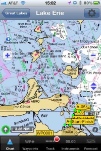
Hands on Review of iNavX Marine Navigation for iOS
The iNavX marine charting app is targeted for recreational boaters. This app allows navigation using NOAA raster charts and a few other proprietary vector and raster chart formats. Users can create waypoints & routes and also record tracks. read more
Garmin BaseCamp app coming to smartphones
July 11, 2012 By 21 Comments
![]()
UPDATE: Read my hands on review of the Garmin fenix.
I don’t know how I missed this little tidbit in yesterday’s Garmin fenix announcement:
A Basecamp mobile app allows users to transfer waypoints and tracklogs to view them on a more detailed map and larger screen of select smartphones.
Garmin GLO brings GLONASS to your smartphone or iPad
July 11, 2012 By 5 Comments
 Garmin has announced the Garmin GLO, a portable GPS and GLONASS receiver that connects to Android and iOS devices via Bluetooth. The company claims it is the first wireless receiver to feature both GPS and GLONASS capabilities. read more
Navionics Marine & Lakes for iOS review
July 9, 2012 By 6 Comments
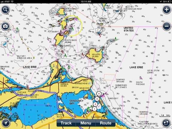
Hands on review of Navionics Marine & Lakes: US & Canada HD
The Navionics Marine Charting app is targeted for recreational boaters. This app allows viewing the proprietary Navionics Nautical Vector Charts on your favorite iOS device. Users can create routes and record tracks, which can be shared with friends using Facebook, Twitter, and email. The routes can also can be uploaded to certain fixed mount chart plotters that might be found on a boat. The Navionics app will function as a chart plotter displaying your position on the chart with the enabled route making it somewhat practical to use as a chart plotter while underway. read more
iOS 6 brings turn-by-turn navigation; Apple licenses TomTom content
June 12, 2012 By 1 Comment
 Apple has provided a sneak preview of iOS 6, letting us know that turn-by-turn navigation is coming to the next version of the iPhone and iPad operating system (click the image above for a larger view).
Garmin Smartphone Link review
June 11, 2012 By 32 Comments
 Update: Now available for iOS (compatible with 2013 Bluetooth nuvis).
I’ve been living with Garmin’s Smartphone Link Android app for a few months now, and there are a lot of things I like about it. I haven’t tested all the features, but I’ll walk you through the ones I have tried. read more
