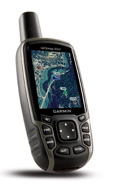
The following has been adapted from my hands on review of the Garmin GPSMAP 62s.
It’s finally here… The Garmin GPSMAP 62st brings a long-awaited update to the fabled and much-loved GPSMAP 60CSx, which has reigned supreme as the gold standard handheld GPS for more than four years. During that time, Garmin experimented with new interfaces, first with the Colorado series, and later with the Oregon and Dakota lines. These have been fine-tuned through many software updates, adding things like paperless geocaching and
the ability to add custom maps and aerial imagery.
With the 62 series (and the boater friendly companion 78 series, which shares the same interface), Garmin has married the best features of the 60/76 models, with many of the advantages of the Oregon line.
The problematic high-resolution screens found on the Colorado and Oregon lines did not make it to the 62 series (although I should note that this problem has largely been solved in the latest model, the Oregon 450). Before we get into the details, lets look at some closely…
Related models
- Step up to the GPSMAP 62stc to add a built-in 5MP geotagging camera
- Or drop down to the GPSMAP 62s and you’ll lose the 62st’s preloaded 1:100,000 scale topo maps, but with all the free maps available online, that may not be a big deal
- The entry-level model in the line, the GPSMAP 62 drops even more features — you’ll lose wireless data sharing, the barometric altimeter, tri-axial electronic compass and the micro-SD slot; even so, this one has enough internal memory to satisfy most people’s needs
- To see how the GPSMAP 62st stands up against other Garmin models, check out my Garmin handheld GPS comparison chart
The top of the line 62st is likely to appeal to folks who do a lot of travelling, and want to always have topo maps loaded. This model also brings shaded relief, which can be added to the mid-range 62s with Garmin’s Topo US 2008 or one of their new 24K regional maps.
Garmin GPSMAP 62st display
With transflective TFT screens, the greater the pixel density, the less light that can be reflected back to the user. In order to maintain the bright screen found on the 60/76 series, Garmin left the resolution (160 x 240 pixels) alone. Screen size remains unchanged too, at 1.6 x 2.2”. The 62 and 78 series do enjoy an increased range of colors that can be displayed (65,000 vs. 256 in the 60/76 series). The result is a bright display, not quite as large or as high resolution as the Oregon series, but with much better visibility in a wide range of conditions. I definitely noticed the lower resolution, but these are the tradeoffs you make. I found the 60CSX and 62 series displays to be comparable in terms of visibility in a wide range of conditions. After using an Oregon for a couple of years, I was a bit surprised that the screen size didn’t bother me. The only time it really seemed cramped was when I had a dashboard showing on the map screen (discussed more below).
Garmin GPSMAP 62st interface
Garmin hit a home run on the interface. They did an excellent job taking the best aspects of the Oregon series and making it work on a non-touchscreen unit. I think it is actually better than the Oregon except for when it comes to text-entry, where the touchscreen excels. The 62/78 series interface makes it much quicker to navigate main menu items.
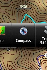 A Page Ribbon menu appears when you press the Page or Quit buttons (see image at right). Just like on the 60/76 series, these buttons advance through pages in forward or reverse order, respectively.
The Page Ribbon menu item that appears is the next screen in the sequence. After a second or two, that screen will automatically open. Or you can press Enter to go there right away, or continue pressing Page or Quit to advance to other pages in the sequence; stop on one and it will open. Page Ribbon items and their order can be customized. I prefer this interface to the old style, but you may not. In that case, you can set the unit to a classic style menu and get the old 60/76 series functionality, eliminating the Page Ribbon.
Newer features on the Garmin GPSMAP 62st
The 62 series inherited a number of features from the Colorado, Dakota and/or Oregon series. These include the ability to utilize Garmin custom maps and BirdsEye aerial imagery, a tri-axial compass, new customization options, advanced track navigation, wireless data transfer and paperless geocaching. None of these were available on the 60/76 series; I’ll explore each in more detail.
Custom maps and BirdsEye imagery
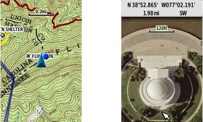
Garmin custom maps allows you to put just about any map image on the 62st. Found a PDF park trail map online? Add it to your GPS! The image at left below shows a custom map — a USGS topo (raster) image. You can read more about this feature by checking out my posts on Garmin custom maps.
With Garmin’s BirdsEye aerial imagery program, a $29.99 annual subscription allows you to add aerial imagery to the GPSMAP 62st. Since I don’t yet have a BirdsEye subscription for my 62s, I’m showing a Jefferson Memorial aerial image using Garmin custom maps, but hey, you get the idea.
Tri-axial compass
Having a tri-axial compass means you don’t have to hold the unit level while navigating. The downside is that the calibration process is more complicated than that for a two-axis electronic compass. It’s the same procedure that is used on the Dakota 20 and Oregon x50 series — here’s a brief video I shot of it. The compass should be recalibrated every time you change the batteries in the unit.
Customizing the Garmin GPSMAP 62st
The 62st offers lots of options for customization. I highly recommend you take the time to set up the following.
Page sequence – You can customize the page sequence by choosing Main Menu > Setup > Page Sequence. This will allow you to select which pages appear in the page sequence and their order. The Page and Quit buttons move forward and backwards (respectively) through pages. I usually put the map screen as my first page and the trip computer last; this way I can toggle between them with the page and quit buttons.
Profiles – The 62st comes with recreational, geocaching, automotive, marine, fitness and classic profiles. You can switch profiles by going to Main Menu > Profile Change. Or create a new one by going to Main Menu > Setup > Profiles. Select the new profile to give it a name. Any changes you make in menus or other settings will be retained in that profile. So start changing things! Want track up when geocaching and north up when biking? No problem. How about a separate profile that just shows USGS topos or aerial imagery? The possibilities are nearly endless.
Data fields – You can change data fields on just about any screen that has these; simply press Menu > Change Data Fields.
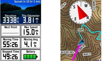
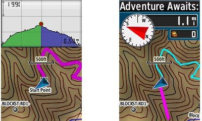
Dashboards – Instead of data fields (and in some cases in addition to), you can select a dashboard for the map, compass and trip computer screens. Choices (depending upon page) may include automotive, stopwatch, small or large data field, recreational, compass, geocaching or elevation plot. I’ve included screenshots showing the last four below. For the trip computer and compass pages, you access this via Menu > Change Dashboard. For the map screen, choose Menu > Setup Map > Data Fields > Dashboard. The one downside here is the small screen on the 62 series; using a dashboard can significantly reduce map real estate.
Track navigation
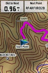 With the GPSMAP 62st, you can select a track to navigate and a route will be created. Waypoints are automatically generated for major high and low elevation points, and start and finish; these and any user waypoints along the track are added to the route. I’m a heavy user of track navigation. If I head out for a trail I’ve never traveled before, I do a search online for tracks (favorite search terms are .gpx, gps, trail name, and park name) and load the track to the device. One advantage of this new track navigation feature is that, unlike typical backcountry route navigation, you’ll get an estimate of actual trail distance rather than “as the crow flies” mileage. Screenshot at right.
Paperless Geocaching
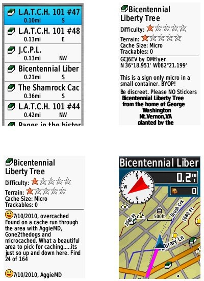
The 62 series is set up for full paperless geocaching support, meaning you can see the description, logs, and hint, and you can log your attempt (find, DNF, etc.) for later transfer back to geocaching.com. Speaking of which, full access to these features requires a premium membership at geocaching.com. Shown below, clockwise from top left: closest geocaches, geocache description, map with geocaching dashboard, recent logs.
Wireless data transfer
The GPSMAP 62st is capable of wireless data transfer with other compatible Garmin units. You can transfer waypoints, tracks, routes and paperless geocache details.
Other features of note
Most of the following aren’t that new, but they are worth mentioning anyway:
Route, Track and Waypoint management 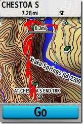
The GPSMAP 62 series has excellent route, track and waypoint management tools, including:
- Waypoints – The ability to project a waypoint, average location, set proximity alerts, and to reposition a waypoint at your current location.
- Tracks – You can choose to hide or show multiple tracks on the map, view an elevation plot, and give them a custom color (17 colors are available). The image at the right shows a track in red (a record of a previous trip). The color of the active track may also be changed. There’s a good thread at the GPSMAP wiki that delves more into track archiving and storage. The 2.44 beta firmware update brought additional archiving improvements; hopefully this will make it to a non-beta release soon.
- Routes – You can view a map of the entire route, edit the route, reverse it and view an elevation plot.
Ability to utilize free maps
One of the most awesome things about Garmin mapping units is the huge number of free maps available. My favorite site for these is http://gpsfiledepot.com where you can find 1:24,000 scale vector topo maps for most states.
Auto use
While I would prefer the Oregon 450 as a dual use unit, due to its touch screen (which is significantly larger too), the 62 series is capable of giving turn-by-turn directions when loaded with City Navigator maps.
Under the flap and inside
Under the protective weather cap is a mini-USB port and MCX external antenna connection. Just so it doesn’t trigger questions, I’ll mention that the item beside the antenna connection is a screw. Inside the battery compartment is a micro-SD slot for additional map and data storage. Note that the photos are of the 62s, and not the 62st.
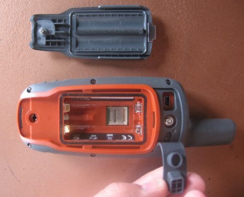
One hardware note here. The battery holders can be very tight with rechargeable NiMH batteries. I actually had to pry the batteries out of a 62s that I tested, though my wife could remove them with her amazingly strong fingernails! The batteries popped out of the other test units with a good slap, and I expect that even tight ones will loosen up over time.
Carabiner and mounting system
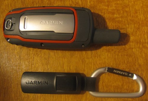
A rail mount on the back of the unit allows the included carabiner to slide onto the device (shown below on the 62s). This is the same system used on the Colorado, Dakota and Oregon lines so the related accessories are interchangeable. I’ve heard some people say they don’t trust the carabiner mount, but after using it on my Oregon for a couple of years, I can say that I’ve never had any problems with it. Personally, I really like it and find it very convenient for clipping onto my pack.
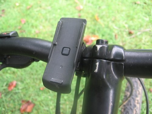
Garmin’s bike mount uses the same system, as shown below. I didn’t like this at first, since it’s just a zip tie system, but after a reader suggested using pliers (to pull the zip tie tight) and a screw driver (to press against the base of the zip tie slot), I’ve found that I can get it quite tight. I’ve never had a unit pop off the mount, though it is possible to slide it on incorrectly, so be aware of that. Also, low profile mounts such as this one seem much safer to the rider, in case of a crash, than ones that protrude.
Auto mount kits that utilize this rail mount connection are also available.
Garmin GPSMAP 62st performance
For a detailed look at the performance of the 62 series, please check out that portion of my GPSMAP 62s review.
Creaks and bugs
There have been a lot of reports on message boards about units that creak when pressed on opposite sides of the case. I have seen, um, heard this on each of the 62 series units I tested. On the first, you could hear it when powering the unit of and off. It wasn’t as bad on the other two I tested. Whether this portends other problems over the life of the unit is unknown.
With new handhelds, you can typically expect some bugs in the early firmware. The 62 series certainly has these, but many are minor or esoteric. One of the more common and unresolved complaints I’ve heard is that the reported battery level stays on full, and then drops to 3/4 charge shortly before the battery dies. Until this is fixed, when the battery level shows any drop, it’s nearly time to change to a new set!
Garmin GPSMAP 62st tips
I imagine there are more, but here’s a few tips:
- Use the zoom buttons to jump a full page in a menu
- When entering a name, the zoom buttons will switch between keypads
- You can create a custom startup message (e.g., if found, please call…) by connecting it to your computer and editing the Garmin/startup.txt file
- The 60 series header showing battery status is gone; you can check the 62 series battery level by briefly pressing the power button, but you may also want to dedicate a data field to it.
Garmin GPSMAP 62 pros
- Excellent menu system; fast access to features
- Bright screen
- Ability to load Garmin custom maps and BirdsEye aerial imagery
- Paperless geocaching
- Tri-axial compass
- Extensive customization options
- Advanced track navigation
- Pre-loaded 1:100,000 scale topo maps
- Wireless data transfer with compatible units
- Accurate total ascent readings
- Generally accurate tracklogs, especially with latest beta firmware
Garmin GPSMAP 62st cons
- Small, low resolution screen
- Text entry more difficult than on a touchscreen Oregon
- Relatively heavy (compared to Oregon series)
- Most units seem to sport a creaky case
- Firmware still seems a bit immature
Conclusion and recommendations (updated)
Updated to reflect my testing of production (non-beta) firmware version 2.50.
Recommended. Garmin has nailed the user interface, and the improved performance under the 2.50 firmware has eliminated my previous reluctance about tracklog accuracy. Is it as good as the 60CSx under any and all conditions? Possibly not, but it does show a lot less multipath error when standing still. And it seems to settle down a lot quicker. Those two factors alone could make this a great unit for geocachers.
The 62 series models are some of the best handheld units available today. If you’re sitting on a 60CSx and have been wanting to get a Garmin with new features like BirdsEye aerial imagery, custom maps, advanced track navigation, and paperless caching, it’s probably time to pull the trigger. The performance of the new models is pretty darn close to the 60CSx. You might want to wait for the price to drop a bit, but if you’re holding out for firmware nirvana, I can almost guarantee that when (and if) that day comes, there will be something newer and shinier waiting in the wings, with all the troubles we typically see on new units.
More Garmin GPSMAP 62st reviews
- Consumer authored Garmin GPSMAP 62st reviews
have been posted at Amazon
- The Geocaching Podcast crew does an early test of the Garmin 62st, comparing it to several other receivers
- Geocacher reviews of the Garmin GPSMAP 62st
I’ll be posting links to more hands on GPS reviews as they appear, but in the meantime, here are some…
Other Garmin GPSMAP 62st resources
- A PDF version of the Garmin GPSMAP 62st owners manual
- This chart will show you how the Garmin GPSMAP 62st compares to other Garmin handhelds
- A Garmin GPSMAP 62 series wiki
- The official Garmin GPSMAP 62st web page
Compare prices on the Garmin GPSMAP 62st at these merchants:
- Check the current Garmin GPSMAP 62st
price at Amazon
- Check out the deal on the Garmin GPSMAP 62ST GPS
at REI.com, where satisfaction is guaranteed and members get 10% back on eligible purchases
- Buy the Garmin GPSMAP 62ST Rugged High Performance Handheld GPS Receiver w/ U.S. Topo Maps
at Tiger GPS


Great review – I’ve just ‘upgraded’ from the 60CSx to the 62st – checking the software revision on the unit it states v2.4 – I go onto the Garmin web site and it says v2.44 beta. Where can I get the v2.5 unit software?
Download WebUpdater at http://garmin.com/webupdater and run it to get the latest software. And let us know how you like the 62st!
Thanks for that – it’s up to v2.6 now too…
I have been researching GPS handheld units for my employer to give to her son for Christmas. He is a serious hunter. I have narrowed the choices down to the Garmin 60CSx and the Garmin 62st. Money doesn’t matter. I have read about everything you have written on each unit, but I am still asking what do you think the best choice is for user friendly, accuracy, practicality, etc.? Sometimes new isn’t necessarily better overall. Thank you.
I really like the 62 series. The ability to add aerial imagery could be very important for a hunter. The 60 series does have more mature firmware, but it lacks quite a few features and it tends to bounce all over the place when you are standing still. I’d go for the 62s or 62st.
thanks for all these reviews. After losing my Oregon 450, I’m considering buying a GPSMAP 62st but needed some background. This helped! Are you able to answer one question however? Will I be able to access/use the pre-installed topos on the 62st even though it’s used? Does that matter?
This is a good review, but I’m curious about how the satellite “sensitivity” of the 62st is. The “SIRF” on the 60CSx works just amazingly and gets you a location even under thick vegetation or deep canyons (which I think is the real advantage over the other units). However, I have not been able to find any comparisons between the 60CSx and 62st in this regard, and I did not see the SIRF listed under the 62st specs. Any comments about this?
Thanks. I tested performance on the 62s. You can read about that at http://gpstracklog.com/2010/08/garmin-gpsmap-62s-review.html#performance and http://gpstracklog.com/2010/09/update-on-garmin-gpsmap-62-series-performance.html.
The 62 series uses the STMicroelectronics Cartesio chipset. While the firmware may need a little more tweaking, I prefer this to older SiRF III models, which tend to bounce around like crazy when stopped. One more link…
http://gpstracklog.com/2010/02/getting-over-sirfstar-iii.html
Good Morning,I Bought the GPS 62st,last week,I went and download the BirdsEye View Image,Now I Have No Maps what so ever,All I get is a white screen,Plz Help
Press the menu key twice, then choose Setup > Map > Map Information – Select Map. Do you see a box for BirdsEye imagery? Is it enabled?
In mass storage mode, can you see a Garmin/BirdsEye folder? Can you see your other maps in the Garmin folder? Perhaps gmapbmap.img or gmapprom.img.
That’s the question i’m looking for,I don’t have any of that,when I go to Map Screen,All i get is a blank white screen,I tried your method and I don’t get Map Information,Thx
Do you have a backup? You may have erased the maps on the device some way. I expect you’ll need to contact Garmin to get them restored.
No Back Up,Will Garmin Restore,And Thanks So Much,Happy Holidays
Yeah, I can’t imagine that they won’t. Phone calls are faster than email for resolving things with them, but expect a 30-45 minute hold…
http://www.garmin.com/garmin/cms/site/us/support/supportcontact
What is the latest software update for the GPSMAP 62st? I believe I may have done something wrong when uploading it from My Garmin Dashboard. At first it said it did not properly upload and so I tried it again, and now My Dashboard said the software is updated . . . The GPS Unit says Version 2.8. I guess the key is to plug the GPS unit into the computer and not turn it on?
2.80 is the latest non-beta version. When you plug it into your computer, it should go into mass storage mode.
Hello Rich,I went and got a new GPS 62st,I’m trying to use my birds eye view,how does the GPS recognize birds eye view on SD Card.Thx & Happy Holidays.
Nother question,can you only use one birds eye per GPS 62st,Plx let me know,Thx
You can load multiple files. From BaseCamp, right click on the file and choose Send to > SD Card.
Hello all,
Currently I’m seriously considering a Garmin 62S/78S (Since I believe they are almost the same) for use on my motorcycle (on- and offroad). What I really would like is a function in which I could mark stretches of road I ‘like’. For example, around my hometown I know my way around some nice twisty roads or nice stretches of dirttrack, it would be awesome if I when I’m riding around could just record a track in some specific color which would always be visible on the map… Well, long story but I hope you guys know what I mean, would such thing be easy to get around with the 78/62?
Oh and btw, my compliments ont he site, you’ve got some nice community here!
Yes, you can record a track and the set it to always display on the map. Be aware that, for highway use, you might want or need to buy City Navigator maps to go with it. These units do not come with a detailed, routable highway map. There are free topos and free highway maps available, but they won’t give you turn by turn directions.
Wow, that’s what I call a fast reply!
Okay, and how user friendly would that be? Can I just hit one button or do I have to dive into the menu’s?
And how would you consider the road-navigation capabilities of this device?
Thanks a bunch man!
You would need to save the track and then set it to display on the map. It would be a few button presses, but not too many. It’s not too hard, but if you’ve never used a handheld GPS before, there will be a learning curve.
Generally speaking, handhelds aren’t great for road navigation. Have you looked at the Garmin zumo series? They are designed for motorcycles, but I don’t know if they have the track display capability you’re looking for.
Well I have quite a lot of experience with navigation software on smartphones, which works pretty good but the hardware doesn’t last that long 🙂 So I’m looking for something more robust. I’ll just go to the local GPS shop and try the 62 and 78, I especially like the 78’s waterproofness and it’s powerconnection…
They are both very good units. You might want to look at the Oregon 450 too.
Well, had a play with the 62s and Oregon 450 today (they didn’t have the 78s which I actually had on top of my list, but I suppose it’s similar to the 62s). In fact I was quite dissappointed with the speed of the devices, scrolling over the map isn’t really snappy also zooming requires some patience… The devices felt pretty solid though and the interface seemed quite nice…
I am considering the purchase of the 62st. I have used a Vista c for a number of years, but it now seems to shut itself off a lot when on the trail.(Thus the possible upgrade). My questions concern the past use of Mapsource, and the future use of Base Camp. Will Base Camp be able to use my Mapsource files which I have accumulated over the years? And if it will, how would I get them into Basecamp? And further, will I be required to purchase a new edition of Topo USA, or will my old edition of the maps work with the new 62st?
Thank you for your informed replys.
Yes, you can import .gdb files into BaseCamp. I don’t have a Windows version running, but it should be similar to on a Mac (File > Import).
I assume you mean MapSource Topo, but you won’t need it if you get the 62st, since the maps are pre-loaded. I’d suggest the 62s instead though, combined with some of the free, more detailed (1:24K) maps available at http://gpsfiledepot.com. Previous versions of MapSource will work with the 62s, however the pre-2008 versions don’t include digital elevation models for terrain shading and 3D. The 62st does have this built-in.
Good Evening Rich
I”m trying to change my direction Icon< Ihave downloaded a few for direction(Ski-doo,monster truck)how do I add it to my garmin GPS 62 st,Thx
I don’t think those icons are compatible with handhelds, just nuvis, etc.
Rich, I’m going to a new area of Wy and Ut this year to bow hunt Elk with my 14yr old son. I have an old ETrex that does not have map download capabilites and so I am going to buy the latest greatest for my use. I am a “keep it simple stupid” not so techy kinda guy that wants to be safe in the mountains. I am however a Mac, I-Phone/Pad user (who loves Google Maps/Earth) and a map/land guy who is somewhat of a hard core hunter. I will go where the elk are and spike camp for weeks at a time 10+ miles if needed. I would like to be able to access 1/24,000 topo and good quality Arials. I liked your review on the birds eye view of the Garmin 62st. Sometimes the arials available that I know of for mountain areas are week at best. I am going to check out some of your map site recomendations and if you know of more please pass them on. Is the 62st for me or do you have other recomendations. I live in Olathe KS where Garmin is headquartered and I’m a buy local loyal kind of guy. My old gps seemed terribly slow and not very easy to use however it has saved my life. Also another feature I would like to see incorporated is a Rescue Alert function such as a product called The Spot provides. If something bad happens and my only chance of survival is Search and Rescue I will use it if i’m able. I won’t go deep in the mountains with out this type of product ever again. I may have to purchase this unit seperately. Let me know your thoughts please and thank you.
Check out the demo version of TopoFusion for aerial imagery. They may (or may not) have something better. If they do, it can be loaded as custom maps. You’ll be limited as to how much area you can cover, but it may still be worthwhile.
DeLorme has the PN-60w/SPOT combo, but I’d prefer the 62s plus a separate solution. If you have an iPhone or Android smartphone, there’s the new SPOT Connect device that would be a good option. I should have a full review posted in the next two weeks.
I’d look at the 62s (no need to spend more for the 62st just to get 100K maps) or the Oregon 450. This may help…
http://gpstracklog.com/2010/07/garmin-gpsmap-62s-or-oregon-450.html
I downloaded a series of maps from a spring trip to the Escalante. I would like to share these maps from BaseCamp with a fellow Garmin GPS user. I have e-mailed Garmin with the “how to” question, but would be interested in hearing your commentary on how Garmin maps can be shared with other fellow Garmin GPS users. This person happens to have the identical unit. Thank you very much for any input on this topic.
Your fellow GPS user should just download them to BaseCamp too. Or connect his device to your computer to transfer them.
Escalante rocks, BTW! I did a 5 day backpack in Coyote Gulch with a sidetrip to Stevens Canyon, and have also done some technical slots there – Davis Gulch and Egypt 3.
Just upgraded from an Etrec c to 62st with the US Topos. I live in Canada and have been trying to load my TOPO Canada map. map source will not recognize the 62. Downloaded Basecamp and trf, TOPO to Basecamp and now I am attempting to trf. the files to the 62, however it has been downloading for 24 hrs and is still only 30% complete. Obviously, I am doing something wrong. can you suggest. E-mailed Garmin 4 days ago, no response.
I expect they’ll get back to you soon, since the holiday weekend is over. It usually takes at least 24 hours to get an email response.
I don’t know why it would be taking so long. You might just want to start over and try again. It should only take a few minutes.
What should the interface function be set at, optiona are:
Spanner, Serial NMEA in/Out
text out, RTCM
It defaults to serial which is what most people use for data transfer to a computer. Spanner can keep it from going into mass storage mode (more info here: http://www.gpsfix.net/oregon-and-colorado-connection-modes/). This can be helpful when using non-Garmin power cables.
NMEA is primarily for marine use, and is used to stream data:
http://www.garmin.com/us/products/onthewater/nmea2000
http://garminoregon.wikispaces.com/message/view/home/5075415
Text out can also be used to stream a limited amount of data:
http://www8.garmin.com/support/text_out.html
RTCM is used for differential GPS correction (DGPS): http://www.gpspassion.com/forumsen/topic.asp?TOPIC_ID=113013
Hope this helps!
used NMEA and it worked 🙂
think I read somwhere that basecamp wont work with Serial (that was the mode I tried originally). Anyhow I now have my TPOP loaded. Now have to figure out all the neat stuff the 62st can do.
found the source
◦Windows XP Service Pack 3 or later is required.
◦.NET framework 3.5 SP1 is required. A current version of .NET will be installed if needed.
◦Windows Media Player 11 or greater is required (a free download from Microsoft).
◦1 GB of system memory is required, 2 GB of system memory is recommended when using BirdsEye Imagery or Garmin Custom Maps.
◦A video card that supports OpenGL version 1.3 or later is needed to enable the 3D view.
◦If you experience problems when interacting with the map views, please make sure that you have installed current video card drivers.
◦BaseCamp will recognize all MapSource products except BlueChart.
◦BaseCamp does not work with serial GPS devices.
——————————————————————————–
I think there is a definition issue here. Even though the unit has a serial interface, it doesn’t use a computer’s serial port. My 62s works fine with BaseCamp when set to serial.
well, I am definetly not e techie. Hopefully some day Garmin will get back to me and explain why I couldn’t load using the serial format on my 62. Meanwhile, I got my TOPO loaded and am happy.Thanks very much for insight.
P
I have an intermittent problem with the 62st booting up. It locks at loading Profile for 7-8 minutes then displays the map showing the western half of the U.S. No answer from product support. Does anyone else have this problem?
Thanks in advance
Could be a corrupt profile… http://garminoregon.wikispaces.com/message/view/home/18738765#18739133
Or a bad .gpx file.
I expect the former is the most likely. If you ever switch profiles, that could explain it being intermittent.
Hi, im trying to realize why in “classic profile” when i chose “navigate to” it will create a line towards the point while in “recreational” it tells me i cant create routes with current maps?
Also , im i right when I assume I cant navigate turn by turn with the preinstalled topo map? Thank you!
While you’re in the classic profile, go to Setup > Routing and change the Guidance Method. Then that setting wil be retained for the Classic Profile.
No, the pre-installed maps don’t do turn by turn. Some other ways to do this:
http://gpstracklog.com/2011/06/garmin-topo-us-24k-review.html
http://gpstracklog.com/2010/07/navigating-tracks-on-the-new-garmin-handhelds.html
Thanks for you help in the previous post. Now, is there a way to change the “night view” settings? I like to be able to see the shaded relief of the maps even at night.
Thank you
Setup > Display > Colors / Mode & Setup > Mode. You could also create a special night profile to make switching eaiser.
Thanks! I was searching all over for that setting.
Glad to help!
All right, maby my 2 last question 🙂
1: Ive heard of people using 4GB SDHC micro sd cards, som even have used 16BG.
On the specs there is no support for sdhc cards, only sd. Do you know exactly up to wich size or what class that is supported?
2:
Also, this model does support more then one gmapsupp.img files in the /garmin folder, ive confirmed that. But how many will it be able to read? And is there a good way to change the names of the .img files. Like gmapsupp_scandinavia.img, gmapsupp_uk.img, gmapsupp_24k_topo_eu.img.?
To you have any suggestions? Right now I just dropped a gmapsupp.img in the garminfolder on the device without changing its name. It booted up fine along with the preinstalled europe topo map.
Thanks!
I don’t think there’s any problem using SDHC cards, and yes, I’ve heard of folks going up to 16GB. I’d just buy a reputable brand.
You can’t have multiple maps with the same file name. The preloaded maps aren’t called gmapsupp.img. This should help…
http://gpstracklog.com/2011/05/loading-multiple-maps-to-garmin-devices.html
will the garmin work in nicaragua central america
Yes, but read the “airport problem” in this post…
http://gpstracklog.com/2012/01/what-to-do-about-gps-reception-problems.html
Hello,
I’m looking for a handheld GPSr, primarily to be used for geocaching. I’m torn between the Montana 650 and the GPSMAP 62. Up until now (500+ finds), I’ve been using a smartphone with the c:geo app, so I’ve become used to a larger touchscreen, and I use aerial photos a lot — all of which seems to point towards the Montana. But I also do quite a bit of hiking, so I’m wondering if the large size of the Montana would be cumbersome. Also, in reading between the lines, it appears that the GPSMAP is a bit more accurate? (Does Montana have the “quad-helix antenna”?) Price is no object. Any suggestions?
Thanks,
Brent
The 62s may be a bit more accurate, but I don’t think there is a huge difference, and no, the Montana does not have a quad helix antenna.
Be aware that the Montana’s touch screen is resistive, not capacitive like your phone, so it will take a slight bit of pressure to use the touchscreen.
I don’t find the Montana to be cumbersome, but I’m used to carrying a ton of gear with me anyway! I’d say go somewhere you can hold one and see for yourself. The Montana’s biggest advantages IMHO are the fact that it can be used as an auto navigator (no more entering the trailhead into another nav unit) and the extensive customization options. Hope this helps.
Another technical aspect you might want to consider is that neither the Montana nor the 62ST has support for GLONASS, whereas the Oregon, Monterra, and Etrex do (I’m surprised that the ETREX has this, being Garmin’s low-price handheld model). GLONASS is the Russian equivalent to the American GPS system, and consists of 24 SV’s (space vehicles). Having GLONASS capability in your handheld GPSr offers the following benefits:
1. If you are using your GPS in any area where view of the sky is restricted, for example a deep canyon, those extra Russian SV’s may allow the unit to get and maintain a more precise fix than otherwise possible. Say you are hiking in Zion National Park, down in the canyon, and your view of the sky is a rectangle only 10 degrees wide and 30 degrees long. If your GPS is a “regular” model that only uses the American GPS satellites, you might have only 2 or 3 SV’s visible at any given time, and that’s not enough to get a 3D position fix. Even if your GPS can see 4 SV’s, and initialize and get a lock, the PDOP (positional dilution of precision) will probably be really bad, and your tracklog will bounce around all over as the satellites move in and out of view. With GLONASS capability, an ETREX, Oregon, or Monterra might be able to see a total of 6 or 7 SV’s in the same location, and give you a much smoother tracklog and fewer initialization dropouts.
2. The GLONASS satellites travel in orbits that reach slightly higher latitudes than the American GPS constellation (a lot of Russia lies much further north than most of the United States), so a GLONASS capable Garmin unit may give you somewhat more accuracy and fewer “lost lock due to insufficient number of satellites” problems if you ever travel to Alaska or Scandinavia.
There is one disadvantage to the GLONASS capable Garmins, and that’s reduced battery life. The radio frequency receiver and processing chips in the GLONASS capable units have to be more robust, with more channels, more data throughput, and more processing speed, and of course that requires more electrical power. I used a Trimble R8 (this is a $25,000 Survey-grade GPS receiver) for a lot of my field work from 2008 to 2012, and I can state from personal experience that when Trimble upgraded the R8 from the Model 2 to the Model 3, the addition of GLONASS to the Model 3 made a HUGE improvement in the unit’s overall reliability. When we were doing any surveying work near trees, high retaining walls or soundwalls, or adjacent to buildings or big road signs, the Model 3 ran rings around the Model 2 for overall performance and reliability in those difficult-to-use-GPS conditions.
I have been using the old 6 disk national geographic topo software for many years and have many waypoints in tpg format that I transfer back and forth between Nat Geo Maps and my Garmin rhino 120. Now I have a new Garmin 62st and the new Nat Geo software (i.e., TOPO Arizona 7.5’ maps). The new Garmin 62st makes tpo files. How can I convert the old tpg file data into the tpo format? Basically, I really need to be able to transfer my old data points/files to my new Garmin 62st. My data consist of waypoints and routes. I do not do geocaching. I presume it would be best to retire the old Rhino 120 and leave future work to the new technology.
I have a feeling that I have opened a new can of worms and that there is going to be some relearning here. Help get me going. Keep in mind that I am pretty well versed in the old system but may need to be taught with some step by step detail, as I’m not a geek.
Hope you can help.
Answered at http://gpstracklog.com/search-results/comment-page-1#comment-166186
Hi Rich, I have a 62st and was wondering if anyone was having problems with waypoints dissappearing from the unit?
Go to Waypoint Manager > Menu > Sort > Alphabetical. Now do you see them? If not, is your firmware up to date?
Bought the 62st just before Christmas last year. I do a lot of geocaching and hiking in the nearby mountains. After a few months unit started to turn off by itself, and lose tracks, (can’t afford to loss tracks). Contacted Garmin after I tried all the recommended stuff on Garmin’s website, take batteries out, hard reset, update to newest software. Nothing worked, got a replacement from Garmin, after a couple of weeks later starting to do the same thing. Finally went back to store I had bought the original from and got another brand new unit. Couple of months later the unit would display all my saved tracks at once, would have to go to tracks and remove track to hide on map. That worked for a couple of days, then back to showing all tracks on map. Unit has turned off 4 times since I recieved it, hopefully no more. Updated software again, I know they aren’t updating software at Garmin every couple of weeks. Same thing. Hard reset again (I just love the time you spend setting the unit back up again.) Hopefully on this last unit, and I mean last unit, (I will go back to the original store for full refund) this last update will take hold. I’ve owned the 60csx for a number of years and it was my right hand, especially on the trail, this unit (62st) when it’s working is just about the same but you can’t tell me there isn’t software or hardware problems that Garmin should of worked out before placing the 62st on the market. For the money you pay for this item it should of been extensively tested beyond all reasons. Any suggests for regaining my confidence in this failing unit?
I’ve heard numerous reports of shutdown issues, not just with the 62 series, after the last few rounds of firmware updates. Is it the same thing triggering shutdown each time? If so, I would report it to [email protected]
Thanks, it doesn’t seem like it’s the same functions although I really having been paying too much attention of sequences of pages.
I have a loaner 62ST that I am experimenting with, and I want to power it off of my desktop PC so as to save batteries, but every time I plug it in with a USB cable, it goes to Data Transfer mode. I can’t find a setting in the menus to force it to just use the USB cable for power and boot up into Regular mode. I have tried the trick of holding the down arrow on the rocker while plugging it in, and during the boot up process, and it still goes to Data Transfer mode as soon as POST (power-on self-test) is complete. Am I missing something, or is there NO way to power it from a PC or laptop into “regular” mode? I don’t have a USB wall charger with a MINI-B plug (my cell phone charger is a Micro-B, so that’s not an option).
I am trying to decide if I want to replace my lost 60CX with a 62s, or an Oregon. I like the form factor of the 60CX/62s, and I think the 62s Quad-Helix antenna works better than the Oregon’s patch antenna in a hiking/backpacking scenario where you have the unit clipped to your belt or in a pocket. On the other hand, the Oregon is GLONASS capable and has a higher-res touchscreen, which are powerful advantages over the 62s.
Settings > System > Interface > Garmin Spanner, but I don’t think the Spanner software supports anything beyond Windows XP: http://www8.garmin.com/support/download_details.jsp?id=1627
An alternative that might work is GPS Gate:
http://gpsgate.com/products/gpsgate_client
http://gpsgate.com/support/using_a_garmin_gps_as_input
Unit can store up to 20 routes BUT it’s not able to sort them alphabetically!!!!!!! Major drawback.
Should have said “200 routes”. You can just about manage 20 routes unsorted!!
When I turn mine on all I get is a white screen