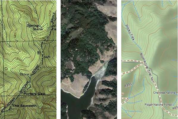
With today’s topic, I’m starting a new series, a follow up to my Handheld GPS 101 posts. Are you ready to move on to the next class? Alright then. Today’s topic is mapping software — and I’m not talking about maps for your GPS here, but rather desktop or laptop software that will turn you into a power user.
Why use desktop mapping software?
First of all, the scale is much larger, giving you a better feel for the overall area you will be traveling through. And in general, planning a trip is much easier on your computer than on a GPS. A side benefit I’ve noticed is that planning on the big screen helps you gain quite a bit of geographical awareness before ever going out in the field. Depending upon which software you choose, you can do the following with it:
- Create waypoints for trailheads, destinations, trail junctions, geographic features, benchmarks, etc., and then transfer them to your GPS (using the cable that came with your GPS)
- View tracks of trails; these can be hand-drawn or downloaded from various sources online, and transferred to your GPS
- Create routes and transfer them to your GPS
- Toggle between USGS topos and aerial photos
- Download your track and marked waypoints after returning from a trip to keep a record of your travels and stats
My favorite mapping software options
TopoFusion
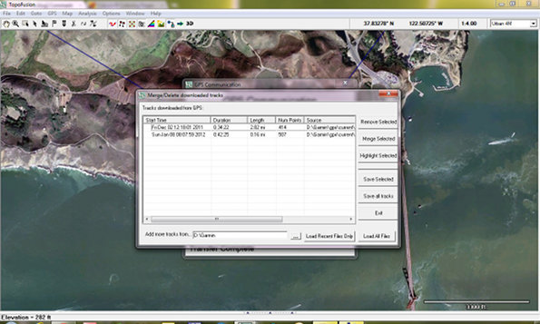
This is my favorite mapping software for Windows. TopoFusion comes in a free demo version that never expires, as well as $40 and $69.95 versions. I love the ability to toggle between aerials and topos, and it has the best track importer around (shown in the screenshot below). Download the free version for that if nothing else. Now if they’d only produce a Mac edition! Click the image below for a full size view.
National Geographic TOPO!
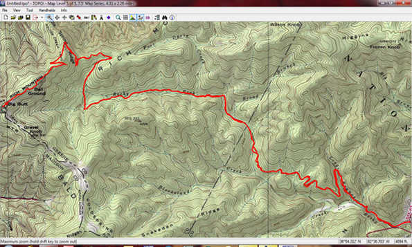
The price on this one was recently cut in half; you can now get the National Geographic Topo state series for $50 or less, and sometimes that includes multiple states. While I’m not a big fan of how they handle routes and tracks, this is my favorite software for printed maps. And there’s nothing quite like having a hard copy of a map in your hand with the same waypoints you have on your GPS. Great for Windows; the Mac version sucks.
Garmin BaseCamp
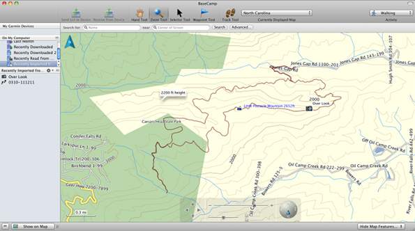
While BaseCamp isn’t the most intuitive thing Garmin has ever created, it is free, and it’s the only way to get BirdsEye aerial imagery or BirdsEye topos on your Garmin. Plus, you can use free topos from GPS File Depot with it. Available for both Mac and Windows.
Other options
There are many other options out there, including programs like Topo North America for DeLorme owners and ExpertGPS, but I’m not going to try to list them all. Unfortunately, I’ve yet to try a Mac program I’m happy with that has the capabilities of TopoFusion and/or National Geographic TOPO. Those programs are why I keep a Windows machine around.
Stay tuned. I think we’ll look at downloading tracks from the Internet in the next installment of Handheld GPS 201.


Also worth mentioning that the National Geographic State Series maps can be loaded on Magellan Triton series GPS devices. On Garmin, you can send tracks/routes/waypoints from Nat Geo to the GPS, but with a Triton you can actually send the map itself.
However, with a newer model Garmin handheld (like the ones named for states), you can subscribe to BirdsEye topo and that will give you the same maps (scanned USGS 24k topo’s)
Thanks Boyd. Good comments. That’s the problem with posts like this, where to stop. Right before posting it, I thought maybe I should say something about Google Earth. But unlike these other programs, it’s not designed specifically for GPS, so I left it out.
I wonder how many Tritons are still in use. I have a bricked 1500 that I’ve never even tried to revive!
Good question. My Triton 1500 still works fine, but I don’t use it. Kind of a klunky user interface that doesn’t quite know whether it’s touch screen or button based. The little toothpick-sized stylus is pretty funny. I also find the buttons way too hard to push.
Actually, I bought mine to run OziExplorer CE using the native Windows CE operating system and bypassing the Magellan software. That worked really well, but I just lost interest. You might be able to revive your Triton and run OziExplorer if you want. I posted how to do it here: http://forums.gpsreview.net/viewtopic.php?t=12646
Back before Mitac bought Magellan, they marketed a professional GIS device called the MobileMapper that was the same hardware as a Triton 2000 in a black case with full Windows Mobile OS.
I pretty much agree with everything you say here. Topofusion is my go-to software for most planning purposes, but I do keep Nat Geo Topo! lying around (an old version of Back Roads Explorer with the 100k topos) for printing. I use it less and less because it handles tracks POORLY. I don’t know if Nat Geo has improved the way their software handles tracks or not, but on mine that I’ve tried to keep reasonably updated, it cannot send tracks to the GPS as tracks. It always wants to convert the tracks to a route and reduce the number of points before it sends to the GPS.
I don’t use a Mac, but I keep hearing that Ascent is the best available for Mac. Have you tried it, what’s your opinion of it?
Yeah, NG doesn’t export tracks. It imports them okay, but not the other way around.
Thanks for the tip on Ascent. It looks to be more of a fitness app and as far as I can tell there is no way to add waypoints, but I’ll keep playing around with it.
I thought it would be worth pointing out that there is one fundamental distinction between ExpertGPS and all the other ones that you named here (perhaps BaseCamp might be an exception; I’m not too familiar with that): In addition to doing all the basics that you’ve mentioned in this article, ExpertGPS behaves like a true “GPX file editor”. TopoFusion seems to be built around the (incorrect) assumption of “one GPX file = one GPS track”. NatGeo TOPO does not make any distinction between “routes” and “tracks”, which is a material difference for many GPS receiver models. ExpertGPS is the only one allowing you to view, create, edit, delete multiple tracks, multiple routes, multiple waypoints within a single GPX file, along with every other conceivable operation that can be performed on any of them. (And, no, I’m not affiliated with ExpertGPS…
I don’t think Topofusion operates on that premise. It permits you to merge many tracks into a single file, or split them apart as you see fit.
But on this, .gpx is an imperfect format because it can be interpreted differently depending on which program you use. Its original use was to describe point, route, and track features, and using a program to make it do something else can result in odd behavior if you want that file to be portable. .kml files work better for this and for popular distribution, but shapefiles (which is a format compatible with Topofusion) and geodatabases (GIS software only) are much more adept at maintaining a collection of tracks or trails (that may or may not interconnect).
Interesting. I think I’m not aware of the functionality in TopoFusion to which you’re referring.
What I see happening in TopoFusion is this: You open a file using TopoFusion, and it becomes an entry in the “File List” displayed under the map view. Each entry in that list has columns displaying things like length, moving time, average speed, total climb, etc. To me, those look like quantities that would apply to an individual track.
When a GPX file with multiple tracks in it becomes an entry in that list, I don’t see how those columns can show meaningful values for that entry. TopoFusion attempts to show “aggregate” numbers for a file, when this happens. But, for instance, if you load a file with two tracks whose timestamps are a month apart, it shows the “total time” of the “file” as 30+ days. Of course, this becomes completely inconsistent with any meaningful value that TopoFusion can display in the “pace” column for that file.
Perhaps more importantly, there is no way of looking at all the stats of one of the tracks in that multi-track file on its own. Yes, some stats are available on the elevation profile dialog of a track, so I can open that dialog for one of the tracks and look at those values, but there are plenty of stats not shown in that dialog that seem to be impossible to see on a per-track basis in TopoFusion when multiple tracks are in one file.
There are other features that don’t make sense on a per-file basis when a file can have multiple tracks. For example, you can right-click an entry in the file list and select “Climbing Analysis”. What exactly does that mean, if that file contains five separate tracks? What would it mean if it has three tracks and two routes? Would the routes be aggregated into the analysis along with the tracks? Features like that Climbing Analysis really only make sense when each file is expected to have only a single track (or route, as far as their functional equivalence can be taken). That’s what I meant when I wrote that TopoFusion assumes that “one GPX file = one track”.
Similarly, I find no way in TopoFusion of viewing a tabulated list of the trackpoints in a track. You can look at the elevation profile of a track and kind of see some of these values as you mouse-over back and forth across it. But mousing over to look at a single field that keeps changing is not the same thing as browsing a tabulated list, and some stats would take a ton of on-the-fly arithmetic (such as “distance from the previous point”). ExpertGPS also allows things like converting a route to a track and vice versa, which you would expect a “GPX editor” to do, and which TopoFusion doesn’t.
So, in that sense, TopoFusion doesn’t really behave like a generalized “GPX editor” as much as ExpertGPS.
I see what you’re saying. No, Topofusion does not compute separate stats for different segments in a track file that contains multiple tracks. It’s all summed together.
This gets back to the original design of the .gpx file format where 1 .gpx file contains 1 route or 1 track (or potentially a collection of waypoints).
Forcing everything into a single file is a bit beyond what most GPS receivers can handle, anyway, so why would you want to do that in the first place?
That’s true.
I think I personally got into the habit initially simply because I could, since I’ve been using ExpertGPS longer than I’ve been using TopoFusion. One thing I do is to set up a route for mountain biking in advance of a ride by gathering multiple tracks I find on the Internet that partially overlap with the route I plan to ride, place all of them in one map/file in ExpertGPS, then hand-trace a new route along the trail segment I’ll ride, followed by saving all the downloaded tracks along with my own route in a single GPX file as a way of “filing it away” for future use.
It can go beyond that, though. When I trace a trail as a track/route, I sometimes add a few standalone labeled waypoints along the way, so that I can see them on my GPS screen as I pass by them during the ride. I think it’s natural in this case for those waypoints to be saved into the same GPX file as the track itself, since they will also be uploaded to my GPS together. Of course, a few extra waypoints in a single-track GPX file may not confuse TopoFusion as much as multiple tracks, but it’s just an incremental example of a case where it’s sensible to have more than just “one track” in a GPX file.
A better example might be representing multiple trails in one locale as multiple tracks in a single GPX. (Of course, technically it’s possible to represent any interconnected trail network by a single track, but that would be too cumbersome and would involve too much backtracking in the case of spur trails, not to mention the inability to represent disjointed trail segments…) This works pretty well as an informal trail map of a park that can be directly uploadable to my GPS. Just open the file in ExpertGPS, highlight all tracks in the list, right-click and pick “Send to GPS”. One might argue that there are other file formats out there that are better suited to representing trail maps digitally, but I doubt any of them are directly transferable to an outdoor GPS receiver.
If I’m the only one who’s noticing this shortcoming, it might be a case of “if you never get used to it in the first place, you don’t miss it”.
I agree that the way most GPS receivers handle .gpx files is a shortcoming. I should be able to load up a file and have it display the same on my computer and my GPS. But that’s not the way it actually works.
I keep all of my .gpx files as 1 track, 1 file in folders, currently archived by year. Topofusion allows you to merge all of them into a “network” arrangement that’s nice, but in practice I find that it can’t handle dense trail networks well. Have tried it on a few different locations and no matter how I adjust the settings, important segments get removed, so I also resort to hand-drawing trail networks, but I put those into a different file format so I don’t confuse them with tracks that I can load onto the GPS and follow.
I can put them into .kmz format files and have Topofusion send them as a “Garmin Custom Map” onto my Oregon as one option. that can have whatever overlays I want in it.
The other thing I can do is take my hand-drawn network file, put it into a .gpx format as an intermediary, and use the tool GPX2IMG to turn it into a transparent basemap file I can overlay on top of the other basemaps in my Oregon.
I wasn’t aware of that capability in ExertGPS, so thanks for sharing.
FWIW, TopoFusion breaks down multiple tracks in a file (right click a track in the file list > Properties). You can also see individual track points in this view.
What a hoot that I stumbled over this today. I am the developer of Gmap4 (http://www.mappingsupport.com/p/gmap4.html) which is one of the “many other” general purpose mapping programs. I am on the verge of turning on a trip planning feature to generate GPX files (waypoints/route/track) and while doing some related surfing, stumbled over this report.
I have new info to throw in the pot. Gmap4 is going to be displaying a new set of topographic map tiles (USA only) that are significantly better scan quality than any other topographic tiles that are available from other Google Map API-based mapping software. These new tiles do not have any watermarks and are ad-free. How does their quality compare to Topofusion? Well I don’t know but I’m sure curious to find out.
Here are a couple links to my beta code showing these new topo maps:
Yosemite National Park, California
http://www.mappingsupport.com/p/beta/gmap4_beta_trip_plan.php?ll=37.747949,-119.588662&t=t4&z=15
Sunrise area, Mt. Rainier, Washington State
http://www.mappingsupport.com/p/beta/gmap4_beta_trip_plan.php?ll=46.916349,-121.641462&t=t4&z=15
Did I mention you can vary the hill shading? Menu ==> Hill shading
So how do these topo tiles compare to Topofusion, etc?
wow, those new topo tiles are awesome!
Oh, wait. I can answer my own Q. Silly me. Too much info to keep it all straight sometimes.
Topofusion uses the MyTopo maps. I now refer to those maps as “medium resolution”. You can easily compare for yourself since the Gmap4 beta version (see link in prior post) displays both the MyTopo maps and the new hi-res topos. (It also displays the low-res Terraserver (aka Microsoft Research Maps) topos.
Joseph,
Very cool. A couple of questions:
What is the source of the hi-res topos?
Can I view a local GPX file in Gmap4?
Thanks for the kind words.
Hi-res topo source = CalTopo.com + USGS
For more background:
To save on typing, I hope you don’t mind if I refer you to:
http://www.nwhikers.net/forums/viewtopic.php?t=7996276
I’m Joey. You can read as a guest – no need to register.
Gmap4 cannot yet display a file from your local drive. At the present time you have to place your file online in order to display it. It can be placed online almost anywhere. I recommend Google Sites.
In the future I hope to add a feature that will let you load a file from your local drive into Gmap4 and then edit that file with the new trip planning tools.
That would be a nice feature.
Going back to the 101 class and start from scratch but guess I have to purchase or try a free version to get the tracks I saved while horseback riding onto a real map I can print out???
… hopin’ I didn’t waste money on the GPS I bought, It has helped me out twice on the trail in 6 months. Also, I’m at the end of my memory 99% so what do I do or will it automatically delete to make room?
Glad I found this site, thanks for all the great tech talk in terms us laymen can understand (kinda)…LOL… the Garmin site sucks IMO.. I bought the Etrex Legend H by Garmin for XMas.
You can print a map using Garmin’s free BaseCamp program and one of the free maps from http://gpsfiledepot.com. You’ll get a better looking map using something like National Geographic’s TOPO state series though…
http://gpstracklog.com/2012/01/handheld-gps-201-mapping-software.html
I thunk the Legend H wil start overwriting the track once it hits 100%, but I’d have to see the Track setup page to be sure. Regardless, you can save the track from the track manger and them clear the active tracklog. You can save up to 20 tracks. It’s best to put them on your computer with BaseCamp though, so you have a record of them elsewhere. Hope this helps!
Thanks, going to try these links now.. yesterday I spent an hour downloading (I thought) the software you suggested in the 101 class (free version) and it wouldn’t run for some reason (said no authorization). I am SO glad I found this page, may have more questions and I will definately let you know what I get figured out for others in my wake.
Thanks for the great articles on this site I’m coming across. I ditched using software and instead tried out several online versions. MapMyRide worked well for a while but has too many annoying ads now, so RideWithGps is my routing site of choice now. You can switch maps between OSM, OSM cyclemaps, google satellite, google maps, google terrain, old usgs maps, and a few others, making it extremely versatile. I mostly use my GPS for cycling, with some hiking, and found this process to work much better (and cheaper) than using Garmin Mapsource with their expensive mapsets. Of course, GPSfiledepot has great topo coverage maps, but the OSM routable maps found elsewhere show both roads and trails very well, but without topo lines unfortunately.
Interesting. I’ll have to try it out. Thanks!
And check out http://garmin.openstreetmap.nl/
I had just came across it recently, and loaded the maps on my etrex 20 and it routes amazingly well (though it assumed I should be going 85+mph on the highway…). I was too stingy before and have been using Metrgoguide maps from 1999 until now, so it’s amazing to have free routable maps, in addition to the great topo ones from gpsfiledepot
I bought the basic version of TopoFusion. I am not finding the instructions particularly useful for a neophyte and email requests for help haven’t produced any. I have a file of tracks and multiple files of patches to the tracks to make everything look lovely on paper. If I check all those files and use SAVE SELECTED AS will they all be compressed into a single file? Also is it there a way to be able to insert waypoints consisting of circles of selected diameter and color instead of the elaborate images found in TopoFusion?
Have you asked or searched at http://www.topofusion.com/forum/?
I’m a wetland scientist, I Use a Garmin 64s to mark waypoints as I delineate wetlands and streams. I need a reliable GIS mapping software to produce my wetland waypoints on aerials and topo maps. I don’t want an expensive software package, any suggestions? I’m thinking of Expert GPS. Thanks