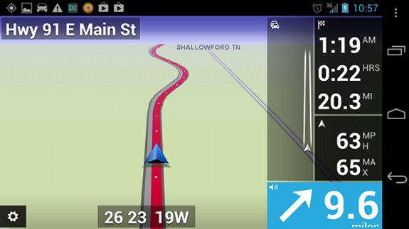
Wow, how much can the mobile navigation market change in just a couple of days? Following Garmin’s announcement yesterday that they will develop navigation apps for multiple platforms, Navigon reveals that they are bringing MobileNavigator to the US Android marketplace. I thought perhaps that TomTom had decided to take on the free Google Maps Navigation juggernaut last week, but (as suspected) it turns out that they are only providing maps for HTC, and not navigation. So Navigon becomes the first top-tier navigation app maker to go mano-a-mano with Google, to see if folks will pony up or settle for what the search giant gives us for free.
Navigon MobileNavigator for Android comes to US
CoPilot Live USA for Android launches at $4.99
ALK Technologies has announced CoPilot Live USA for Android for $4.99. I would say it will test whether consumers are willing to pay for an alternative to Google Maps Navigation, but it is currently ranked #48 in iPhone navigation apps with an average three star review, far below much pricier apps.
Peak.AR review
Augmented reality for the backcountry
Peak.AR is a free augmented reality app for the Android and iPhone platforms, that allows you to identify distant peaks by simply pointing your phone’s camera at them. Pretty cool huh?
My Tracks for Android
My Tracks is a free Android app that allows you to record and share GPS tracks. Incredibly easy to use, it layers your track onto Google Maps or satellite view (as shown above). Getting the track off your phone is as simple as saving the track, selecting the drop down More button and then Share with Friends, which gives you the options shown below at right. The GPX and KML options attach the file to an email; I love how easy it is to send a track to my computer this way. You can also create waypoints (“markers”) with the app. My Tracks is not a navigation app, but it is a great way to share locations and check the GPS accuracy of your Android phone. I’ve included the QR code below, so you can use a bar code scanner to download the app.
Two free apps help name that peak
Hey What’s That goes mobile
It’s been quite a while since I wrote about Hey What’s That?, a website that helps you identify mountains on the horizon. Well, today comes news that they have a mobile app for Android and iPhone (here is their mobile FAQ). So I tweeted about it and @CompeGPS turned me onto…
Peak.AR
Peak.AR (iTunes link) is a free augmented reality app that looks much better. There’s a screenshot at the top of this post (note that both English and German languages are supported). It’s limited to the iPhone now, but an Android app is expected by the end of February.
Google Maps Navigation launches
It’s official, Google has launched a free turn-by-turn navigation app – Google Maps Navigation. It’s in beta, and is only available for Android 2.0 phones (e.g., Verizon Droid), but I can already say that this is a huge change for the GPS navigation industry.
Not the nav app you’re looking for


Recent comments