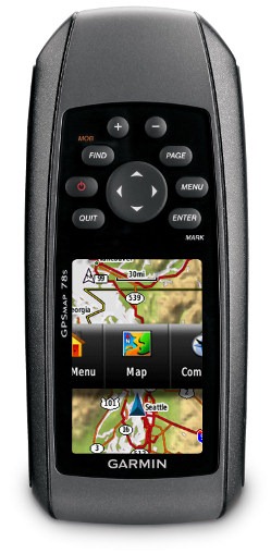
Hands on with the Garmin GPSMAP 78s
The Garmin GPSMAP 78s brings the first major update to the GPSMAP handheld line in over four years. The reason for it taking so long is that Garmin had a huge hit with the 60/76 series, and instead of messing with a winner, they turned their attention to new interfaces, which were introduced on the Colorado series, followed by the touch screen Oregon line. These new units brought the ability to add custom maps and aerial imagery, paperless geocaching, and high-resolution screens, but the latter made them less than bright (although the latest model, the Oregon 450, has largely solved this problem).
But patience has its rewards and Garmin did well not to rush things. With the 78 (and the forthcoming 62 series, which shares the same interface), Garmin has married the best features of the 60/76 models, with many of the advantages of the Oregon line. Before we get into the details, lets look at some closely…
Related models
- Drop down a notch to the GPSMAP 78 and you’ll lose user profiles, wireless data sharing, the barometric altimeter and tri-axial electronic compass
- Going the other direction, the GPSMAP 78sc adds pre-loaded marine charts for the coastal US to the features found on the 78s
- To see how the GPSMAP 78s stands up against other Garmin models, check out my Garmin handheld GPS comparison chart
Garmin GPSMAP 78s display
With transflective TFT screens, the greater the pixel density, the less light that can be reflected back to the user. In order to maintain the bright screen found on the 60/76 series, Garmin left the resolution (160 x 240 pixels) alone. Screen size remains unchanged too, at 1.6 x 2.2”. The 62 and 78 series do enjoy an increased range of colors that can be displayed (65,000 vs. 256 in the 60/76 series). The result is a bright display, not quite as large or as high resolution as the Oregon series, but with much better visibility in a wide range of conditions. I definitely noticed the lower resolution, but these are the tradeoffs you make. Also of note, speaking as the owner of an Oregon 400t, I really didn’t miss the larger screen.
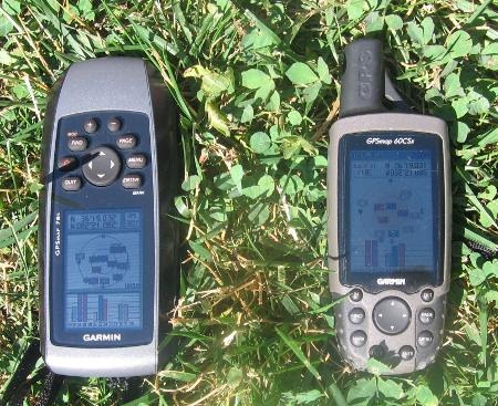
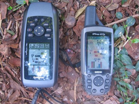
Shown above and below are sun and shade photos, without backlight. It is difficult to capture screen visibility on film, but I would call these two displays comparable in a wide range of conditions.
Garmin GPSMAP 78s interface
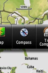 Garmin hit a home run here. They did an excellent job taking the best aspects of the Oregon interface and making it work on a non-touchscreen unit. I think it is actually better than the Oregon except for when it comes to text-entry, where the touchscreen excels. This new interface makes it much quicker to navigate main menu items.
A Page Ribbon menu appears when you press the Page or Quit buttons (see image at right). Just like on the 60/76 series, these buttons advance through pages in forward or reverse order, respectively.
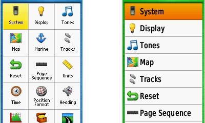
The Page Ribbon menu item that appears is the next screen in the sequence. After a second or two, that screen will automatically open. Or you can press Enter to go there right away, or continue pressing Page or Quit to advance to other pages in the sequence; stop on one and it will open. Page Ribbon items and their order can be customized. I prefer this interface to the old style, but you may not. In that case, you can set the unit to a classic style menu and get the old 60/76 series functionality and eliminate the Page Ribbon. A Classic profile comes pre-loaded, Shown below are examples of the Setup menu in classic (left) and list (right) styles.
For boaters
The 78s is lightweight (7.7 ounces with batteries), but bulky (2.6″ x 6.0″ x 1.2″), likely due to the desire to make it float. One other marine feature worth noting is that the Find button doubles as a Man Overboard (MOB) button – hold it down to set a waypoint and begin navigating to it. The GPSMAP 78s accepts a wide-range of Garmin’s inland and coastal charts.
Though ostensibly for boaters, the 78 series predecessor 76 line was popular with landlubbers as well. Quite a few folks like the buttons above the screen, rather than below. So don’t be scared off because it is “for boaters;” layout and form factor are more personal preference issues.
Newer features on the Garmin GPSMAP 78s
The 78 series inherited a number of features from the Colorado, Dakota and/or Oregon series. These include the ability to utilize Garmin custom maps and BirdsEye aerial imagery, a tri-axial compass, new customization options, advanced track navigation, wireless data transfer and paperless geocaching. None of these were available on the 60/76 series; I’ll explore each in more detail.
Portions of the following are adapted from my previous reviews of the Dakota and Oregon series.
Custom maps and BirdsEye imagery
Garmin custom maps allows you to put just about any map image on the 78s. Found a PDF park trail map online? Add it to your GPS! The image at left below shows a custom map — a USGS topo (raster) image. You can read more about this feature by checking out my posts on Garmin custom maps.
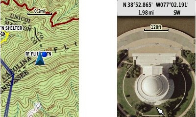
Garmin also recently announced their BirdsEye aerial imagery program, a $29.99 annual subscription that will allow you to add aerial imagery to the GPSMAP 78s. Since I had a review unit without a BirdsEye subscription, I’m showing a Jefferson Memorial aerial image using Garmin custom maps, but hey, you get the idea.
Tri-axial compass
Having a tri-axial compass means you don’t have to hold the unit level while navigating. The downside is that the calibration process is more complicated than that for a two-axis electronic compass. It’s the same procedure that is used on the Dakota 20 and Oregon x50 series — here’s a brief video I shot of it. The compass should be recalibrated every time you change the batteries in the unit.
Customizing the Garmin GPSMAP 78s
The 78s offers lots of options for customization. I highly recommend you take the time to set up the following.
Page sequence – You can customize the page sequence by choosing Main Menu > Setup > Page Sequence. This will allow you to select which pages appear in the page sequence and their order. The Page and Quit buttons move forward and backwards (respectively) through pages. I usually put the map screen as my first page and the trip computer last; this way I can toggle between them with the page and quit buttons.
Profiles – The 78s comes with recreational, geocaching, automotive, marine, fitness and classic profiles. You can switch profiles by going to Main Menu > Profile Change. Or create a new one by going to Main Menu > Setup > Profiles. Select the new profile to give it a name. Any changes you make in menus or other settings will be retained in that profile. So start changing things! Want track up when geocaching and north up when biking? No problem. How about a separate profile that just shows USGS topos or aerial imagery? The possibilities are nearly endless.
Data fields – You can change data fields on just about any screen that has these; simply press Menu > Change Data Fields.
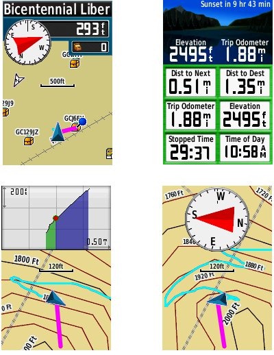
Dashboards – Instead of data fields (and in some cases in addition to), you can select a dashboard for the map, compass and trip computer screens. Choices (depending upon page) may include automotive, stopwatch, small or large data field, recreational, compass, geocaching or elevation plot. I’ve included screenshots showing the last four below. For the trip computer and compass pages, you access this via Menu > Change Dashboard. For the map screen, choose Menu > Setup Map > Data Fields > Dashboard.
Track navigation
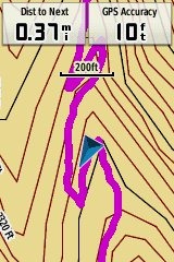 With the GPSMAP 78s, you can select a track to navigate and a route will be created. Waypoints are automatically generated for the high and low elevation points, start and finish; these and any user waypoints along the track are added to the route. I’m a heavy user of track navigation. If I head out for a trail I’ve never traveled before, I do a search online for tracks (favorite search terms are .gpx, gps, trail name, and park name) and load the track to the device. One advantage of this new track navigation feature is that, unlike typical backcountry route navigation, you’ll get an estimate of actual trail distance rather than “as the crow flies” mileage. Screenshot at right.
Paperless Geocaching
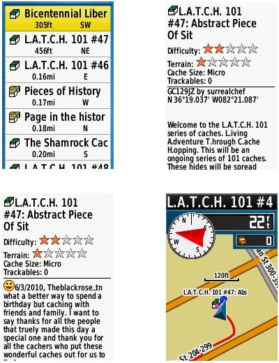
The 78 series is set up for full paperless geocaching support, meaning you can see the description, logs, and hint, and you can log your attempt (find, DNF, etc.) for later transfer back to geocaching.com. Speaking of which, full access to these features requires a premium membership at geocaching.com. Shown below, clockwise from top left: closest geocaches, geocache description, map with geocaching dashboard, recent logs.
Wireless data transfer
The GPSMAP 78s is capable of wireless data transfer with other compatible Garmin units. You can transfer waypoints, tracks, routes and geocache summaries (paperless caching details cannot be transferred).
Other features of note
Most of the following aren’t that new, but they are worth mentioning anyway:
Route, Track and Waypoint management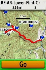
The GPSMAP 78 series has excellent route, track and waypoint management tools, including:
- Waypoints – The ability to project a waypoint, average location, set proximity alerts, and to reposition a waypoint at your current location.
- Tracks – You can choose to hide or show multiple tracks on the map, view an elevation plot, and give them a custom color (17 colors are available). The image at the right shows a track in red (a record of a previous trip). The color of the active track may also be changed. There’s a good thread at the GPSMAP wiki that delves more into track archiving and storage.
- Routes – You can view a map of the entire route, edit the route, reverse it and view an elevation plot.
Ability to utilize free maps
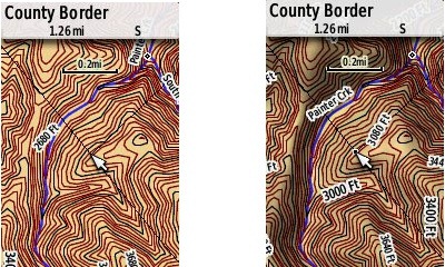
One of the most awesome things about Garmin mapping units is the huge number of free maps available. My favorite site for these is http://gpsfiledepot.com where you can find 1:24,000 scale vector topo maps for most states. An example is shown below, at left. If you want shaded relief though (shown at right), you’ll need to go with Garmin’s own product, either Topo US 100K or their new 1:24,000 scale series.
Auto use
While I would prefer the Oregon 450 as a dual use unit, due to its touch screen, the 78 series is capable of giving turn-by-turn directions when loaded with City Navigator maps.
Under the flap and inside
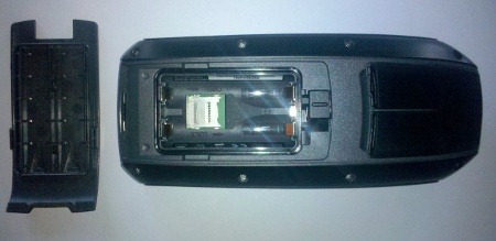
Under the protective weather cap is a mini-USB port, MCX external antenna connector and serial / 4 pin power port.
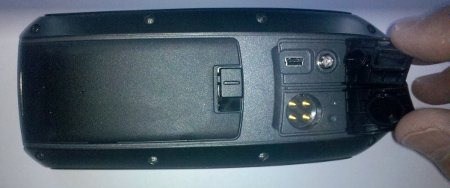
Inside the battery compartment is a micro-SD slot for additional map and data storage.
Garmin GPSMAP 78s shortcuts
I imagine there are more, but here’s a couple of tips:
- Use the zoom buttons to jump a full page in a menu
- When entering a name, the zoom buttons will switch between keypads
Garmin GPSMAP 78s performance
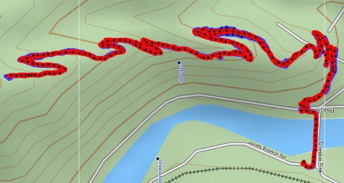
I was very impressed with tracklogs from the Garmin GPSMAP 78s. A couple of representative tracks are shown below. Tracks were recorded on the 78s and my 60CSx, with both set to a track point interval of 5 seconds. Recordings were made out and back, on foot, with the 78s in my right hand, and the 60CSx in my left. This meant that one unit may have been closer to a cut slope on the trip up, but the other unit was in this position on the trip down.
The first image shows a section of the Appalachian Trail laden with switchbacks. The 60CSx is in blue, the 78s in red. Both units performed reasonably well, although the 60CSx seemed a bit worse in terms of maximum tracklog separation – the distance between tracks recorded by it going up compared to coming down, which reached up to 70’ for the 60CSx, vs. around 50’ for the 78s.
The image below shows another out and back, on a day that probably saw a more favorable satellite constellation. Again, the 78s is in red, the 60CSx is in blue.

Despite the apparently clean tracklogs and similar track separation shown by both units that day, I was impressed by how little wandering there was for the 78s when stopped, as compared to the 60CSx. I’ve blown up the start of the trip at the trailhead (below left) and the turn around / break point (below right).
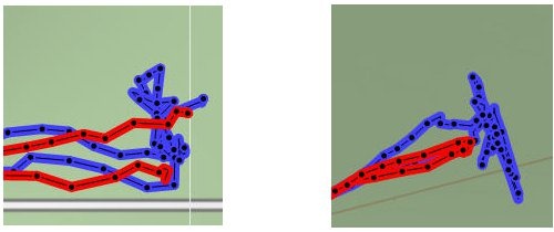
Reporting of position, as evidenced by these tracklogs was extremely impressive. I did notice a definite degradation when the unit was held vertically, likely due to its patch antenna. I’m providing links below where you can download the .gpx or .gdb (MapSource) files below.
- 78s-Chestoa.gpx
- 60CSx-Chestoa.gpx
- 78s-Flint-Cr.gpx
- 60CSx-Flint-Cr.gpx
- 78s-test-Flint-Cr.gdb
- 78s-test-Chestoa.gdb
While the tracklogs looked great, I did see inaccuracies in terms of reported elevation gain. Following one outing where I anticipated a gain of around 1000’, the 78s reported 1512’, compared to 876’ on my 60CSx and 899’ on my Oregon. On another outing, the elevation gain was 366’ according to my 60CSx, but came in at 821’ on the 78s. This appears to be similar to a bug that was recently fixed on the Oregon series (although it seems to have reappeared with the latest beta). Hopefully an early firmware update will resolve it here.
I did not see the unit lock onto WAAS anytime. A recent Garmin Oregon beta firmware update improved this for those units, which also utilize an STM Cartesio chipset, so hopefully a firmware fix for the 78 series isn’t too far behind.
Garmin GPSMAP 78 pros
- Excellent menu setup; fast access to features
- Bright screen
- It floats
- Ability to load Garmin custom maps and BirdsEye aerial imagery
- Paperless geocaching
- Tri-axial compass
- Extensive customization options
- Advanced track navigation
- Wireless data transfer with compatible units
- Lightweight
- Chipset firmware seems very mature, resulting in highly accurate tracklogs
Garmin GPSMAP 78s cons
- Small, low resolution screen
- Text entry more difficult than on a touchscreen Oregon
- Inaccurate elevation gain reports
- Does not work with standard mounts
- Bulky
- Patch antenna adversely impacts accuracy when unit is held vertically
Conclusion and recommendations
Highly recommended; probably the best marine handheld series currently made by Garmin. One reason I say this is due to the bright screen, which should outperform any touchscreen in the kind of bright conditions you’re likely to find on the water.
For landlubbers, I’d recommend waiting for the 62 series, due to be released in late July 2010. Personally I favor the 62 series form factor, with the buttons at the bottom, but you should also consider the fact that, unlike the 78 line, the 62 series uses the standard Colorado / Dakota / Oregon mount, and a wide range of mounting solutions are already available. 78 series mounting options are limited, but will expand as third-party manufacturers begin production.
Garmin has a clear winner with the 62/78 series. The interface is awesome; the Page Ribbon has some clear advantages. Add to this Garmin custom maps, BirdsEye aerial imagery, paperless caching and more. I think there’s going to be a lot of handheld GPS users getting a new toy this year.
More Garmin GPSMAP 78s reviews
- Consumer-authored Garmin GPSMAP 78s reviews
have been posted at Amazon
- Geocacher reviews of the Garmin 78s
- I’ll be posting more hands on GPS reviews as they appear, but in the meantime, here are some…
Other Garmin GPSMAP 78s resources
- A PDF version of the Garmin GPSMAP 78s owners manual
- This chart will show you how the Garmin GPSMAP 78s compares to other Garmin handhelds
- A Garmin GPSMAP 62 and 78 series wiki
- The official Garmin GPSMAP 78s web page
- Apparently the 78s can handle 40 below zero with no problems
Compare prices on the Garmin GPSMAP 78s at these merchants:
- Check the current Garmin GPSMAP 78s
price at Amazon
- Get the GPSMAP 78s Handheld GPS
for a great price at BoatersWorld.com
- Check out the deal on the Garmin GPSMAP 78s GPS
at REI.com, where satisfaction is guaranteed and members get 10% back on eligible purchases


I notice in several of your reviews of recent Garmin outdoor GPS’s, you don’t mention that the Garmin 24K Topo maps also contain routable road map data, similar to the Garmin City Navigator maps.
The update for the 78 which claims to improve WAAS performance was posted this afternoon.
@Allory – Of course. The day I post, they update the firmware! They added geocache filters too — nice.
@Norm – Yep. I’m planning on doing a 24K review after the Southeast DVD comes out.
I bought a 78S yesterday. I found and I have a problem whit them when I want to disconnect the device from my computer. I clicked “safe to remove hardver and eject media”, I selected GPSMAP 78S from the list then the device switched off. I tried with 3 compters and 3 operation systems (win 7, XP, Ubuntu). If I just disconennect the cable the device swithes off too.
Please help! It is a bug, or my device is faulty?
@ Zsolt – Mine does too. I don’t think its a bug. I think they just shut down when you eject.
The tracklog says nothing when its not compared with rectified data material as high resolution images (but not Google Earth, these are too inaccurate). BTW, its not said if the 60CSx was with Sirf or MTK, there are worlds between these 2 units.
I have to disagree. The track locations were under thick eastern forests. I’d be surprised if you could see the trail on an aerial photo.
Good point on the chipset question though. Its SiRFstar III.
Thanks for a great review. I’m choosing between Oregon 450 and GPSMAP 62s, and have two questions:
1) Is it easy to pan a map on the 78s? I recall this being a pain on 60Cx, and would imagine it to be a lot easier on the Oregon (although I never tried one).
2) In general, what are the big pros with the 78/62 compared to the Oregon 450? Screen visibility obviously, and I’m guessing there is a reception/accuracy advantage? I’m trying to figure out what you get for the extra size and weight compared to the Oregon…
Thanks a lot,
Mark
You can pan diagonally; I don’t think that is possible on the 60Cx. I didn’t find panning difficult.
You’re reading my mind with question #2. I hope to have a post by the time the 62 series comes out on whether to buy an Oregon 450 or the 62s. Whether or not it will have better reception is an unknown at this point though.
excerpts from my posting to a UK site:
I got burned badly by the Colorado experience: it lost many valuable 60cs features, no beta testing-ergo full of bugs (the 78 WAAS issue illustrates my fear), clumsy interface, lousy battery life, dumb gasket design that costs US$99 for repair, etc. This new 62 may be just a dakota with push buttons; I don’t plan to be an early adopter on this one-learned my lesson; will follow the blogs for 6 months before plunking down any cash. Fool me once……….
Found a 78 user manual, after reading it I became more frightened that the 62 design has been buggered by the Nuvi team, you know, the same bunch that brought you the the Colorado.
Found a new 60csx for US$200, bought as a backup to my old 60csx in case if fails. In my mind the venerable 60csx is the gold standard for hikers.
I’ve just taken delivery of a 78s. Nice little unit and screen great improvement over Oregon 3000. My only minor quibble is that in spite of setting everything to metric measurements, it appears that proximiy alarms can only be set in imperial measurements.
But have you noticed a little hole in the battery compartment cover? I have. If you hold it up to the light, you can see light through it! Is it really waterproof to IPX7? Before I stick it in a bucket of water to test it, I’m interested to know why it’s there. Doesn’t look like a manufacturing fault.
Doh! And I just sent back the test unit yesterday. You might want to ask at http://garmingpsmap.wikispaces.com/message/list/home
I have just seen the hole in the batterycover, and I allready tested it a couple of days ago if the unit would float.
It does float and there was no water inside the battery compartment.
It’s only 1 hole and with a good sealing there will no water get into the compartment because the air inside has no way to escape.
I just tested it maybe 30 seconds, just to see it floats.
Allthough it floats, I think it’s very hard to find it back in a lake, cause only 1cm of the top end sticks out of the water, and it’s grey color is not very helpfull, maybe a reflecting(?) sticker on the top will help.
Is there at this moment any way too let the 78s work with nRoute, without using a usb-serial convertor?
I know it’s an old program, but on vacations with a mini laptop and no internet connection it’s one hell of a program, and I would not mis it.
Mmm, probably.It appears to work with the Oregon series: http://forums.groundspeak.com/GC/index.php?showtopic=209739
There is no spanner interface on the 78s or I can’t find it.
According to that thread, spanner shouldn’t be used.
Without spanner it allso doesn’t work.
Maybe in the next firmware update? I saw that there is version 2.3, but I can’t find it at the garmin site.
The only thing in the 78s I don’t like is that when connecting too a pc or laptop it goes directly into usb mass storage, in the 60CSx you could choose, why not in 78s?
@Bob K, I think the Waas issue is highly overrated(?)
In my part of the world we have Egnos, when Egnos switched “on” I have a little more accuraccy(?) but as soone I pass a truck that is south of me the accuraccy is less then with Egnos off.
IMHO Waas/Egnos in these type of gpsr’s is a waist of time and money.
I have this unit now for 4 weeks I think, because I had to move to anonther house, I did not had very much time to test it.
Here are some of my findings:
The screen is a (very) little less bright then my 60CSx.
The odometer (the total distance travelled since I got it) can not be reset to zero. When this data is set to a small field in the tripcomputer you only see the last 4 caracters, so 528.8km is shown as 28.8km.
Connecting the unit to a external powersupply will sometimes restart the unit, and sometimes not.
I have a little website of lighthouses with “single waypoint upload”, it’s a button you have to push and a waypoint with a name I gave it is loaded to your gps, so it works with my 60csx, with the 78s I think a file is uploaded with a default name that will be overwriten when you want to upload another waypoint.
The buttons above the screen I see as a big pro, unit is more stable in the hand then my 60CSx.
Birdeye view is a nice gadget, but there is not much contrast in the pictures.
When used to the 60CSx the file handling of the 78 is more complicated, but with all outdoor garmin units you have a learning time, so this one we also will get under the knee some day. After 4 years I still find functions on the 60CSx that I didn’t know off.
I never saw a colorado, oregon or dakota, but I have read a lot about them, mostly negative.
I think Garmin has made the new “top units” with the 62/78 series.
The form/looks of the 78s was the reason I bought it 🙂
Jacob, thanks for taking the time to write this up and share your thoughts. Regarding lighthouses, I haven’t ever seen waypoints being overwritten. Have you verified that this is happening?
When I hit the button, a file with the name “myData.gpx” is made, when I try to get another lighthouse this file will be overwriten, if I choose “OK”
So before you get another waypoint, you have to change the name of MyData.gpx.
Maybe there is already another methode but I don’t know it, made this site a few years ago when Garmin Communicator Plugin was released.
Ah, I see. It’s your site. You might want to ask here…
https://forums.garmin.com/forumdisplay.php?f=55
When connected too my PC I can sent waypoints to the 78s with mapsource, but I can’t recieve them.
With basecamp I can recieve them.
The newer units (Oregon, etc.) handle waypoints differently. I think this is true with all the new models.
Anybody run a battery life test? How about distance measuring between two arbitrary points? When the cursor is scrolled away from current position is there a continuously updated distance/direction display?—-or is it like the colorado only showing a static distance [no direction] and only displayed when you hit a button?
Bok K said “Anybody run a battery life test?”
Didn’t run a test, but 20 hours, don’t think so.
Bob K said “How about distance measuring between two arbitrary points? When the cursor is scrolled away from current position is there a continuously updated distance/direction display?—-or is it like the colorado only showing a static distance [no direction] and only displayed when you hit a button?”
When you scroll you have to use a button, distance is continuously updated, direction is given in directional letters, numeric degrees or in mils, whatever that may be, and is also continuously updated.
I haven’t seen the nRoute thing listed as an issue / fix, but here’s the link for 2.3: http://www8.garmin.com/support/download_details.jsp?id=4995
From the pictures it looks like the USB connector and the MCX connector are under the same cover. So, if I plug an external antenna with a right angle connector, will the USB connector remain uncovered as long as the antenna is plugged in?
Yes, the usb connector remains uncovered with te antenna plugged in
What I mis, can’t find or don’t like.
The ability to move waypoints using the map.
When switching from internal power to external power the 78s restarts.
When switching from external power to internal power I always get the question “stay on” or “switch off”, can’t find a setting “always stays on”
The ability of Custom Waypoint Symbols.
When connecting to a PC the 78s goes to USB mass storage mode.
I found the ability to move waypoints on the map.
– select the waypoint in waypoint manager and press enter, then “menu” and “move” –
Nice find!
Hmm, I was about to buy to replace my 76, but the comments here alarm me. I rely on an external antenna for traverse accuracy and I do work in the rain. I love my custom waypoint symbols, and the fussiness around external power would be truly irritating.
That said, the USB device for custom map transfer would be a plus, but using SendMap utility to dump my custom map files into the 78 is not that much of a pain. Decisions, decision.
Did anyone already recalculated a route, and noticed something funny?
What did it do?
When you recalculate a route (following the road) manualy you have to press “Find” the only option is an offroad recalculation.
When you do this and press the “Find” button again the only option is “follow the road”.
Why this extra step?
Love the site. Thanks. I know I’m a bit late with my comment, but I’ve only just started the search for something to replace my GPS76Csx, which has finally bitten the dust after 3 years. When I saw that the 78 had been launched I got all excited, but now I’ve come down to earth again. I think I’ll be going for another 76 unless anyone has any alternative suggestions.
Why? Well, I need something reliable and cost effective for basic use in a small boat in the Amazon. My GPS is often my lifeline, as I undertake round trips of up to 1500km into territory unmapped apart from what I can get off Google Earth – so not for me the great maps you guys can get “up north”, nor 3-D imagery nor anything else like it. The electronic compass I never use (have one in the boat and always carry a spare), so the 3-axis stuff doesn’t interest me, and the altimeter is pretty redundant on the Amazon!
There is no difference in display size, which I could have got excited about, and from what I read the accuracy of the 78 and speed of acquisition is similar to the 76, so no brownie points there. Wireless transfer? Duh? No use to me. Different user interface? Well okay, but I’m already used to that of the 76. Also, it looks like I’d need a new mount, as the size/shape of the 78 is different (for no apparent reason other than aesthetics (and maybe to sell more mounts?)).
What else have we got? Well not much it seems to me. A battery life improvement, maybe, but then I connect to my 12v supply on the boat anyway, and only use it on the old AAs when I’m trekking short routes in the forest. The “Track Navigation” feature seems interesting, but don’t I effectively already have this on the 76 – I can select a track and turn it into a route – am I missing something?
So at nearly twice the price, I just don’t think there’s enough there to sway me towards the 78 (particularly given that I’ve hardly 2 cents to rub together and will struggle to find the money for a 76! But maybe I’ve misjudged it – maybe I’m overlooking something. Any and all comments appreciated, as I’m (literally) lost without my GPS, and you don’t want to be lost in the Brazilian jungle, you really don’t 🙂
The biggest advantages are custom maps, BirdsEye aerial imagery and advanced track navigation. The latter will give you actual distance to waypoints along a track, whereas with the 76 you can only do distance to the final destination, or switch to as the crow flies routing. But it sure will cost a lot more.
Thanks for that Rich. I think that makes my mind up – the track navigation limitations on the 76 have never been an issue for me, so I guess it’s a case of if I don’t miss it I don’t need it. The aerial imagery is a non-starter here, and there are no custom maps of the area that I know of (and I lack the technical knowledge – and time – to create my own).
One thing though – before I throw the old 76 away, I’m going to have a last stab at getting it running again (there’s no tech support or repair service down here). So, I’ve removed all the screws, but can’t figure out how to prise the casing apart – any tips before I start whacking it with a hammer..?
This might help…
http://forums.gps.org.nz/viewtopic.php?f=7&t=3902
Thanks Rich – yep, it certainly did, and having opened it up I can now see that it is definitively and absolutely FUBAR. Off to find the cheapest replacement I can and someone to bring it down here with them next time they come! Many thanks again and all the best.
Great website with good information. My question to you is, besides the fact that Gpsmap 78 series float and the physical shape is diffrent from the 62 series, are there any diffrences in the operating system? I am looking to purchase the US Inland Lakes card. Could I purchase either one (78s or 62s), pop in the US Inland Lake card and expect that the menus/functionality and screen displays will be the same or very similar? Thank you, Dan
AFAIK, yes. I see nothing in the 78 series or Inland Lakes pages on Garmin’s site to lead me to believe otherwise. Still, it may be worth a call to them to verify this.
The 62 serie has spanner-mode, so you can connect the gps too yuor PC and it still wordks as a GPS.
The 78 has no spanner-mode, and will always switch to USB mode.
But it is software so maybe the 78 will get spanner-mode too.
So there’s no way to get NMEA output? That’s strange for a marine unit.
i have proplem in transfering data to pc
when i conecet my device to pc it dose not transfer way point
They should be in the current.gpx file under the Garmin/GPX/Current directory.
No, the waypoints that you made today are in the map GPS:\Garmin\GPX\Waypoints_04-JAN-11.gpx
You can also put a waypoint file from your PC to GPS:\Garmin\GPX\
Or SDcard:\garmin\GPX\
Don’t know if you can put waypoints in the “current” directory.
Doh! Right you are. Thanks for keeping me straight Jacob.
Great reviews, great site, great reading… thanks so much. I’m a first time GPS buyer, using it for inland kayaking and hiking. I’ve narrowed my interest down to 62s or 78s.
Three questions, two easy are easy, and one is more interpretive.
1) The 78 can be powered from car or wall power via proper adapter cords, and the 62 can only run on batteries?
2) The 62 has both the belt clip, the carabiner clip, and the small lanyard loop, and the 78 has none of the above?
3) Regarding the patch antenna on the 78 models versus the (axial?) style on the 62, and their respective orientation for best use, please clarify what you mean by “being held flat” for solid reception of the 78. Does this mean “perfectly” flat, or 30° degrees off horizontal flat…?
Conversely does the 62 need to be more or less vertical for best reception? In my usage, I would imagine a moderate inclined position in most circumstances, although I guess glare from the sun might be a compelling reason to hold it more vertically if the unit permits.
PS: in my kayak, I have a long open cockpit that makes mounting in front of the cockpit impractical for vision and reach; do you think the unit will be impaired by being using the marine suction cup mount on the bottom of the boat b/w my knees? It is a fairly wide boat and I use no kayak skirt, etc. I’m guessing that the combination my knees & the boat sides would obscure the view of the sky too much.
Thanks so much for your time and effort – this is a great resource.
Charles
1. Garmin sells USB & car chargers for the 62s, but they use the mini-USB port.
2. I believe the 78s has a lanyard attachment.
3. They don’t have to be perfectly flat or vertical. That should just optimize reception THEORETICALLY.
The only things that effectively block GPS signals are water and metal. The kayak shouldn’t matter, but your body may block the signal a little. I expect that the position you mentioned will work fine, with only a little degradation of accuracy.
Selecting the right GPS on a limited budget… not fun. I’ve been undecided for six months! I find it difficult to spend over 350 dollars on something that I’m not sure I’ll be happy with! I want it, I’ve saved the money, but I just can’t seem to pull the trigger on purchasing. Tell you what… if Rich says buy, I’ll buy. My main usage will be on the water. Offshore waypoints, so accuracy is critical. Also, once I land on a waypoint, I need to be able to stay there, meaning once my boat drifts off the waypoint, I need the direction arrow and distance to the spot to be accurate. With my current unit (really old Garmin), once I drift off the spot the direction arrow and distance to the spot goes all wacky until I start moving at a faster pace. This is annoying, because you don’t want to spook fish by moving quickly.
Ha! I’m not going to pull the trigger for you. One option is to buy from some place like REI, where you can return it if you aren’t happy with it.
Hi Rich, and Davey,
REI does not carry the 78, and I was told they do not have it on their special order list.
I would have probably tried the 78 first, and if not overwhelmingly convinced it was worth the extra money, returned quickly for the 62. The flotation, and the orientation of the button was a plus for me.
As I could not have that option of “no questions asked” return on the 78, I ended up getting the 62 on the recent REI anniversary sale for a great price, and am happy so far. I have not really done that much with it as some “real life” stuff has occupied all my attention for the last two months.
However I did test the use a small length of swim noodle as a flotation device for the 62, and it works great – and highly visible in yellow or neon green – the 62 has the same water resist rating as the 78. The lanyard goes through center of the swim noodle and the lanyard hook. Gives me piece of mind, and does not get in my way in the boat. Lanyard is quick release for when I have the unit in hand on land. Kind of like an overgrown version of the boat key chain bobber.
Charles
Nice!
Does anyone here has problems with birdseye view images on they’re GPSmap78 series and firmware version 3.02beta.
After the update from 3.01beta to 3.02beta the images are looking like this
http://www.cobbax.nl/gps/schermen/78/110.jpg
http://www.cobbax.nl/gps/schermen/78/140.jpg
I downgraded to 2.95beta and up again to 3.02beta.
At 3.01beta everything was fine.
With 3.02beta the “problem” appears again.
Here’s a heads up for 78 series owners watching this thread – we’re giving away a protective case:
http://gpstracklog.com/2011/08/gizzmovest-protective-gps-case-review-and-giveaway.html
Rich, I purchased a 78s because I figured loading custom topos and marine charts would be a cinch. My primary topos would be for the White Mts in NH and a chart or two for the areas I sail. Big mistake – should have purchased the 78sc and Garmin topos and Blue Charts. The added expense for these products would have eliminated hours of inconsistent product support (ex. Quote: “Secondly, a paper chart can not be scanned and then loaded to the Garmin device.”)(Quote: “You are correct in that a blank micro SD card does need to be in the device if you wish to download maps. Maps can not be downloaded directly to the device as there is a potential for overwriting the non-detailed basemap in the device.”)
Anyway, I purchased from Garmin a 4GB micro SD, installed it, and nothing happened. It appears that one cannot simply download a ‘kmz’ file directly to the 78s and expect it to find its way into the micro SD. Thus commenced my travel along the learning curve of getting my ‘kmz’ into the micro SD via an adapter which fortunately could plug directly into my laptop…
Yesterday I sent an email to a Garmin product support person who seems to know her stuff. My ‘kmz’ file resides happily in the Garmin folder on the micro SD card, but the 78s can not see my topo. Note: The 78s did see my topo when I had originally moved it directly to the unit’s own Garmin folder.
Rich, thankfully I learned enough about DOS in the 1980s to be able to make texts of my files to share with Garmin. We’ll see…
Meanwhile, please let me know if you have questions or wish to pursue my experience further.
Ollie
I’m assuming you’re trying to create a custom map. Have you created a CustomMaps directory as described here?…
http://garmin.blogs.com/softwareupdates/2009/10/creating-and-using-garmin-custom-maps-in-five-easy-steps.html
And it sounds like you’ve already figured out that the Garmin support quotes were wrong.
Hi Rich. I originally posted here last November (I was trying to decide whether to buy a new 76 or go with a 78). Well, when I (finally) got some funds together I ended up going for…a Montana 600! Someone’s bringing it over for me at the end of the month, and I’ll let you know whether I like it or not. The only thing that put me off was that it doesn’t float, but then I realised that in 5 years of use I had never actually dropped the 76 in the water, so I figured ‘what the heck’!? Let’s hope the decision was a good one. All the best from the Amazon.
Nice! I’m loving mine. Looking forward to hearing how it goes.
I have a GPSMAP 78S. Today I updated it’s software from version 3.40 to version 3.50 with the latest webupdater. It was succesfully, but the device don’t show the barometric and ambient pressure. I made master reset and updated the software again. But the problem is still going on. Please help me.
Does anybody detected this failure with gpsmap 78s or 62s?
Yep, just updated my 62s and verified that those fields report no data. I’m not sure about the best place to report this. It’s not a beta release, but you could send it to the team at
[email protected]
Hi,
I’ve read your reviews on the 62s and the 78s. From a gps function point of view, they seem pretty much the same, except for the antenna. I noticed the 78s is “highly recommended” and the 62s is “recommended”. Can you comment on the different ratings? I’m in a 3 way race between these 2 and the Oregon 450, and have difficulty making up my mind. I will be using it for hiking and kayaking, but I don’t want to base my decision on the fact that one of them floats, but rather on their other merits.
Thanks for a great site
The 62s wasn’t quite as accurate as the 78s when it first came out, but I think it probably is comparable now. Either one is a great choice. I’d avoid the Oregon 450 for kayaking due to visibility issues. Lots of glare on the water.
I’m on my 2nd season with my 78s. Too bad its color isn’t fluorescent orange or yellow for ease of locating if it finds its way overboard. West Marine sells small, bright colored flotation devices that solve this problem.
http://www.expertgps.com: I renewed my license and provided a response to their questionnaire to the effect that I did not want to purchase Garmin’s Blue Charts but was wishing for nautical chart suppliers to also offer charts in a .kmz format for my 78s. Dan Foster came right back with guidance on scanning a nautical chart into ExpertGPS and using its capability to geo-reference your chart or map. This is very easy if your nautical chart has way-points with a table of latitude/longitude specifics. Then ExpertGPS performs the conversion to a Google Earth KMZ file. Very easy! Thanks Dan.
78s gps map download program
I updated the firmware to 4.4 last week and found a new feature, the Temperature Sensor ANT
Anyone allready using this thing, and if so what’s the verdict?
I’m expecting a tempe next week and will post the results of my testing.
Recieved my 2 temp sensors today.
They are accurat as far as I can see right now.
switching for the one sensor to the other doesn’t go automaticcaly(?) or I’m not waiting long enough.
Temp update every 1 minuut.
Customer Service,
Am the purchasing manager representing Cheerful Supplies Inc in
Franklin, Pennsylvania,16323. I’m interested in buying this product in
your stock and the product is listed below.
Items:
15 Qty GARMIN GPS78s
I want you to make a total cost for the product requested including
Next Day Air delivery cost to my office in Franklin,
Pennsylvania,16323 and let me know the accepted credit card among
Visa, MasterCard & AMEX for the payment.
Looking forward to hear from you soon.
Best Regards,
Brown
Purchasing Manager
We don’t sell anything; we just link to places that do.
I am trying to retrieve the route distance between waypoints I have made. In the field I was marking a waypoint at the beginning of a survey, and one at the end. The survey was following a stream, so it is not as-the-crow-flies. Is there a way to go back and find the actual distance walked between waypoints? I have to do many routes throughout the day, up to 30, and setting up a new route and saving it at every survey seems doesn’t seem like it is the easiest way to find the distance I’ve walked for these short surveys. Some of them are less than 30m long. Thank you!
It sounds like you are talking about track distance, not routes. You can see track distance on the device or once downloaded to a mapping program like Garmin BaseCamp. More info here…
http://gpstracklog.com/2010/03/handheld-gps-101-routes-vs-tracks.html
I am a new GPSmap78s user. I found that it is excellent gadget but manual is very weak. I went trough user manual many times , and all short movies at youtube. still I deeply believe at least menu structure has to be supplied with unit.
if anybody has menu structure of 78s , I will be very much appreciated.
for example, some how I can not get rid off POI small logos from my map. they are always there.
or, how can I go directly to POI than add or remove them.?
Kind regards from Istanbul/ TURKEY
I supose that your are talking about POI you didn’t added yourself.
Try this
press menu button
select Setup Map, press Enter
select Advanced Map Setup, press Enter
select Zoom Levels, press Enter
select Map Points, press Enter
scroll to the top
select Off, press Enter
Most of them will be gone, but not all
Do this when your are on the Map screen
Dear Jacob
Yes I have just tried what you suggested, and perfectly did work. Thanks a lot again.
Best Regards
Here’s a wiki for the Oregon series, which has similar functions. That may help… http://garminoregon.wikispaces.com/home
Hi Jacob
I am very much appreciated your comment. I will try it. But still I believe on that there should be menu structure to see menu command hierarchy. if any one have it please share.
Best Regards.
Do you ment something like this?
Setup System GPS Normal
Waas/EGNOS
Demo Mode
Language
Battery Type Alkaline
Lithium
Rechargeable NiMH
Interface Garmin Spanner
Garmin Serial
Text Out
RTCM
Maybe this looks better?
Normal,Waas/EGNOS,Demo Mode
lots of lanquages
Alkaline,Lithium,Rechargeable NiMH
Garmin Spanner,Garmin Serial,Text Out,RTCM
Maybe this looks better?
Setup
System
GPS//Normal,Waas/EGNOS,Demo Mode
Lanquage//lots of lanquages
Battery Type//Alkaline,Lithium,Rechargeable NiMH
Interface//Garmin Spanner,Garmin Serial,Text Out,RTCM
Maybe this looks better?
Dear Jacob
what I mean is something like org chart. http://engineeringnotebook.org/wp-content/uploads/2007/03/org-chart.jpg
any command will be traceable upwards like menu/submenu/sub submenu….. at first glance.
Many thanks to your prompt replies.
That was what I was trying to do, but in this text field it doesn’t work.
It’s a lot of work, because there are a lot of menu’s submenu’s subsubmenu’s and subsubsubmenu’s….and maybe more.
Something for long and cold winternights.
Thank you very much Rich,
This information about Oregon helps a lot. http://garminoregon.wikispaces.com/home
Best Regards
Anybody has experience with, performance of Garminmap78s on very heavy fogy, cloudy and rainy winter days?
It should work well, but I would make sure it locks onto satellites before you start moving… http://gpstracklog.com/2012/01/what-to-do-about-gps-reception-problems.html
About to purchase the 78s and with the sales, it comes as a great price. I’m a canoeist and will primarily use the unit to plan routes, create waypoints for fishing locations, and try not to get lost. Convince me this is the best unit for my use.
1. It floats.
2. It can use Garmin’s BirdsEye satellite imagery, allowing you to see actual shorelines, islands, coves, etc.
Note that it floats in a vertical position, only the tip sticks out of the water, so a sticker on top of the 78 with a bright/fluoriserend(?) color is adviced.
Otherwise it may float but you’ll never find it back.
I must admit, after reading all the information available on what maps to purchase, the reviews, product information, system requirements, features, versions, and support on FAQ, I am confused as ever!!! Is this a case of too much information……or indecision on my part……likely the latter. Perhaps a few direct questions and answers will help…….I hope!
My device is the Garmin GPSmap78s which I am so far very impressed with. I canoe and fish, therefore want to use my handheld to map and follow canoe routes, and fishing locations.
QUESTIONS:
1. Is the TOPO Canada map-Central, the best purchase for my intended purpose?
2. Will I need to download BaseCamp™ or is it already part of the TOPO Canada map?
3. Does the Garmin GPSmap78s have enough memory to download right to my device or should I load it on a Micro SD card?
4. If I purchase the download version, can I transfer routes, waypoints, etc., between my computer and GPS?
5. If I purchase the MicroSD version, can I transfer routes, waypoints, etc., between my computer and GPS?
6. Can other maps be downloaded in addition to the TOPO Canada Central on my GPS?
Thank You for the support, Ron
1. Probably, although there is this too… http://www.ibycus.com/ibycustopo/
You may also want to consider BirdsEye satellite imagery.
2. Probably but I’m not sure. BaseCamp is free though.
3. Unsure. Be aware that there is a 3,000 map tile limit regardless.
4. Yes.
5. Yes, but not to the microSD. FWIW, I prefer DVD versions. I can use them with any unit and always have the DVD just in case.
6. Yes, plenty. BirdsEye is a great choice and check out these… http://www.gpsfiledepot.com/maps/country/ca
Hope this helps.
Thanks for the great advice. I’ve downloaded the http://www.ibycus.com/ibycustopo/ map of Canada. Works great except for some reason I can not transfer my waypoints or routes from GPS to computer. I can transfer successfully my tracks, and there is no problem transferring from computer to my GPS. Any ideas why I can’t transfer waypoints or routes from GPS to Computer?
Are you using BaeeCamp to transfer them?
Thanks Rich for the advice and awesome forum. Do you recommend a website to download BaseCamp from.
Thanks, Ron
http://www.garmin.com/en-US/shop/downloads/basecamp
You may also find this helpful… http://garminbasecamp.wikispaces.com/
5. if the map is a garmin map then the microSD version is usauble in every unit and the dvd version can be used in only one unit.
At the otherhand you can install the map (dvd version) on the PC, wich can’t be done with the MicroSD version.
In the last case (mSD) basecamp reads the map from the unit, so to use the map on the PC the gps must always been connected.
This is for what I know.
Good points Jacob.
I have a 76s (gray scale unit) that I bought in 2002 I believe. Comparing this 78s to the 76s I have a couple of concerns.
One is the battery/MicroSD Card compartment’s latch. On the 76s it was a 1/4 turn latch which kept it secure but also would be almost impossible to open accidentally. I noticed that the 78s has a slide lock, how secure is it? I have seen many slide locks wear over time to the point of being just about useless.
The other concern is that the mount on the 76s, while not standard at all, had two little pins that went into two receiving holes on unit to make sure it couldn’t be easily dislodged during a bumpy ride. The mount for the 78s looks like it is just a pressure lock mechanism. Can anyone comment on this? It is very hard to tell from the pictures on Garmin’s website and they give you almost nothing to go by in the description for the mount.
One more thing I would like to note, the 76s had all of the ports individually covered so that you could expose just the port you needed. I don’t like that they have the mini-usb and the external antenna port under the same flap. One would think there are many times when you would want to use the external antenna port when not wanting to use the mini-usb port. An email I sent to Garmin recently about the use of the ports and maintaining the water resistance had a response come back that the unit only maintains that water resistance when using the four pin data port, not the mini-usb. For a marine GPS that seems to be a bit of an oversight. Why would you want to leave the external antenna port unusable in a marine environment if you needed to maintain water resistance? Perhaps they think you will only need to use it if you are inside a cab an not out in the open, but it still seems ridiculous.
Thanks!
Petaris,
I recently purchased the 78s, but not yet used this season on the water. My use will be in a canoe. I find the latch secure, but can’t comment on it’s durability over time. It requires a fair bit of pressure to lock back into place which may ware over time.
I also have the mount which is a pressure lock system, which seems very secure, given again my use is in a canoe. I will be using the lanyard to secure to my boat for additional piece of mind if the canoe tips. I should note it appears very tight and I would feel confident using in a motor boat as well, but definitely will secure as well using the lanyard.
Your concern about the exposed port is valid, and I can’t really comment about this, given I’ve not had the opportunity to use the ports outdoors.
Aside from your concerns, I am very pleased with the unit.
Ron
Ron,
Thanks for your reply! I always use the lanyard as additional piece of mind as well. Thank you for your comment on the battery compartment latch.
– Petaris
I have my 78s now almost 4 years (3y + 11mnd) and used it a lot.
There is still nothing wrong with the battery latch and the holder also is still working fine.
So I don’t think you have worry.
I have the gpsmap 78s and I was wondering how I could navigate a saved track. With my old etrex legend I had the option to navigate a track from “beginning to end” or from “end to beginning”. Is this option available with this model?
There should be an option in Route Planner after you select a route called ‘reverse route’ that will run it backwards.
Check page 8 of this manual for directions.
Quenton talks about a track, not a route.
On the Etrex Legend there was tracback, on the 78s is also tracback but that doesn’t work like it was on the Eterx.
After 4 years, I still don’t know how it works.
Ah, I totally misread. That makes more sense why Quenton was having trouble. I don’t think you can do trackback on the 78S. At the least, I have no idea how. Sorry I couldn’t help.
Edit: I did a bit of searching and found a comment on a YouTube video about the 78S that has the following suggestion. I haven’t tried it:
“The trackback function in the new GPSMap 78S is not as easy to find as in the older units. You will need to save your track. If you are backtracking be sure to copy it in reverse. Then hit the find button. Select tracks. Then select the reversed track. Then select GO. The unit will guide you down the saved track like it was a road.”
Not really what you were looking for, I expect, but that’s the best I can find. Kind of weird they didn’t include that feature.
I’m on my second 78s now after the 1st one was lifted in a break in at my house a year or so back.Insurance paid for the replacement, that I use infrequntly, but I find its got a consistent problem.
Firmware is patched to the latest, and I use it exclusively with Bird’sEye view images while on holiday to see when we’ve been and how far walked, and to see what’s that over there and how do we get back. All of which for me works fine. Battery life with 1000mah NMHis is days, so happy with that too.
The glitch is it will shut down of its own accord and I’m not sure at all what triggers this, except Its only when the map view is open and probably viewing a BE image. Not sure if zooming the picture or panning the view is the issue, but I know its just very annoying to watch it die or even find it dead when been in your bag and missed some interesting bit of the journey.
Anyone else got this issue or should I return it?
apa bisa gps 78s melakukan real time?
bisa jelaskan kepada saya ?
what it can do real time gps 78s?
can explain to me?