Hands on with the Garmin Montana 600
The Garmin Montana 600 is one of three models in Garmin’s newest handheld series. With it’s huge 4” touchscreen, I had initially thought the Montanas were targeted to the motorized crowd (ATV’s, etc.), but after spending over a month with it, I’m convinced that a lot of hikers and geocachers will be attracted to it as well. Before we get into the details, here’s some info on the rest of the series…
Related units
- Step up to the Garmin Montana 650 to add a 5MP geotagging camera
- The 650t adds the camera as well as preloaded 100k scale topos
- Note that all three Montana models have a tri-axial electronic compass and barometric altimeter
- To see how the Montanas stack up against other models, check out our Garmin handheld GPS comparison chart
Garmin Montana 600 hardware
Display
The Montana’s 4” display, and the features that the expanded screen real estate allows, are some of the prime factors making this an attractive device. The screen is recessed, giving it an extra bit of protection. BTW, that 4” display offers almost twice the viewing area of the Oregon series (45.19 sq. cm. vs. 23.94 sq. cm.), and more than twice that of the 62 series (19.8 sq. cm.)
Visibility is better than the Garmin Oregon x50 series, thanks to a slightly lower resolution screen (relative to screen size; 2889 pixels per sq. cm. vs. 4010 pixels/sq. cm. for the Oregon series), which means significantly more light can be reflected back to Montana users. Personally, I don’t find it to be a huge difference, but it is still another incremental improvement, making it somewhat better than the Oregon 450.
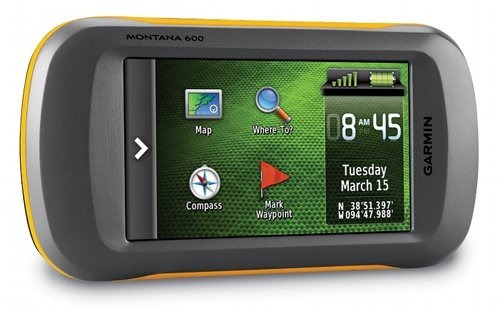
The screen rotates automatically between landscape and portrait views. Interestingly enough, it only rotates three ways, not four. In the image above, it doesn’t matter if the “Montana 600” text on the body of the device is at the top or bottom in landscape mode, but in portrait mode, the “Garmin” text must be at the bottom; the screen will not rotate 180 degrees from this position. One thing I found as a result of having landscape mode available – I can see all of long waypoint names. Nice!
Screen rotation is generally fast, taking just a second or two as long as the unit is being held at an angle approaching vertical. Hold it horizontally, flip it, and it can take quite a while to figure it out, even if you then incline it vertically. In actuality, this takes some getting used to, since many users tend to hold the device at an angle closer to horizontal than vertical.
More exterior pics and hardware details
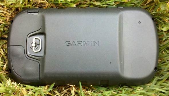
Here’s a pic of the rear of the device (note that it does not have the spine for the now standard Garmin carabiner clip and mount attachments)…
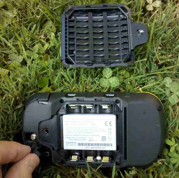
And with the battery cover removed…
The Montana comes with a rechargeable li-ion battery rated at 16 hours, or you can use 3 AAs rated at up to 22 hours (for NiMH). You can also see above that I’m holding open the weather cap to reveal the mini-USB port and an MCX port for an external antenna.
On the left side of the device (or top in landscape mode), you can see clips for mounting systems, the power button and a stereo headphone jack that can be used to send spoken directions (when using City Navigator maps) to your car stereo’s auxiliary input.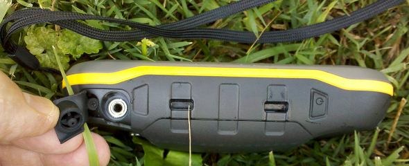
The weather caps seemed to secure tightly and easily. Below is the right side of the device (or bottom in landscape mode), showing clips and contacts for the Garmin mount.
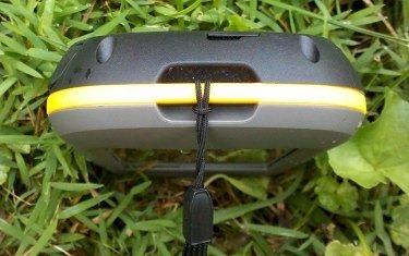
Finally, on the bottom you can see a lanyard attachment point…
Dual-use
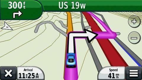
When combined with a Garmin mount that features an external speaker, and City Navigator maps, the Montana can deliver spoken turn-by-turn directions, calling out street names. I have yet to pony up for that combo (though I do plan to test it in the near future), but I have been using the Montana with Garmin’s Topo US 24K, which includes routable roads. I only get a beep, but I am getting turn-by-turn directions, using maps that aren’t locked to a single unit.
As you can see above, there is a “nuvi” mode, which will definitely give you a very nuvi-like experience. It is a true joy to be able to navigate to a cache or trailhead by car, using your handheld. Gone are the days of having to load waypoints to two units.
UPDATE: Here’s a more in-depth look at setting up the Garmin Montana for highway use.
Interface improvements
UPDATE: Here’s a brief video showing some of the improvements:
I covered the items below in my “first looks” post, so feel free to skip ahead if you’ve read this already.
This is where the Montana really shines. The interface brings the best of both worlds, offering the ease of touchscreen input found on the Oregon series, and the easy access to menu items from the 62 series. But that statement doesn’t do the Montana justice; its access to features is light years ahead of my 62s.
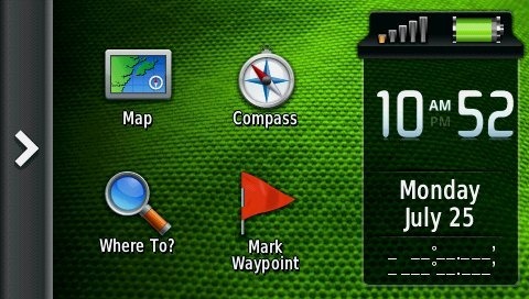
Here’s a look at the Montana’s main menu, which is the screen you’re always greeted with upon startup.
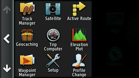
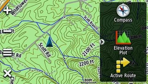
Tap the arrow icon on the right to open the App Drawer.
You can drag apps between the App Drawer and the Main Menu.
If you add more than nine, you’ll lose the names and just have icons. Items in the App Drawer can be rearranged as well.
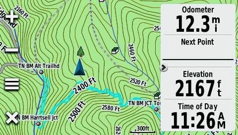
Also new is a Favorites dashboard, shown below. You can have more than three installed; they will scroll within the dashboard.
Note also the arrow icon at the left of the Favorites dashboard above. Tap it to have the dashboard slide out of sight and get a full screen view of the map. Tap the arrow again and the dashboard slides back into view. Nice!
A Shortcuts feature is available from the Setup menu (also from the Favorites dashboard menu). Shortcuts can be added to the Main Menu, App Drawer or Favorites. This feature is a little buggy, with many shortcuts not working. I did manage to place a working shortcut to the display settings on my Favorites dashboard. Once Garmin works the bugs out of shortcuts, you should be able to access just about any feature with a couple of taps.
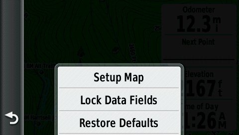
One of the big improvements is also one of the simplest, the addition of the menu icon (the icon with the three horizontal bars below at left).
Tap it on the map screen and you’ll see this…
A simple thing, but two less taps than it takes on the Oregon.
UPDATE: See the last part of this post for another menu tip.
One other note – you know how you can tap the power button on most Garmins to adjust the backlight, see the signal strength, time of day and battery status? Well you can add a dashboard there as well. My personal favorite is Shortcuts. So now I can tap the power key and get access to a few functions that would push me past nine apps on the home screen – items like Display setup that allows me to enable screen shots. Very nice indeed. Hat tip to Boyd for turning me onto this possibility.
Other recent features
I recently posted five six reasons to buy one of the newer Garmin handhelds, and the Montana series has all of these capabilities. Follow the link above for more details on each:
- Garmin BirdsEye aerial imagery
- Garmin BirdsEye Topo US and Canada
- Garmin custom maps
- Advanced track navigation
- Paperless geocaching
- Profiles
Garmin Montana 600 performance
Tracklog accuracy
I tested the Montana side by side against the Oregon 450 and GPSMAP 62s on multiple out and back trips. On each of these trips, I checked to see how closely each device could replicate the track it recorded going out with the one it recorded coming back. In general the Montana performed very well; not quite as accurate as the Oregon and 62s, but pretty good for a brand new unit in a test where later firmware revisions tend to improve things significantly.
For example, in one test against the Oregon 450, the Montana exhibited a few track separation errors of up to 35’, whereas the Oregon 450 only had one that large. The Montana wasn’t that much less accurate, but it did tend to exhibit a larger quantity of notable errors.
In a test against the 62s, the Montana had five errors ranging from 33 to 55’, where the 62s rarely produced errors over 21’. The exceptions were a couple of single stray track points laid down by the 62s – one was a 30’ error and another, right up against a large rock face, was off by 45’. At the same location, the Montana showed one error of 15’. This may indicate that the Montana is less susceptible to multipath errors than the 62 series.
Tracklog accuracy shouldn’t be a big issue unless you’re on a knife-edge ridge in a whiteout.
Odometer accuracy
Odometer accuracy was very good, showing results within 3% of that shown by my Oregon 450 and GPSMAP 62s.
Geocaching accuracy
I’ve yet to come up with a good way to test geocaching accuracy. There are just too many variables – accuracy of the cache coordinates, satellite constellation variability, terrain (multipath effects), etc.
So having said that, here’s a very unscientific test. After becoming familiar with the unit, towards the end of my testing, I made some cache runs. I set the units down on top of the cache one at a time and recorded the reported distance to cache. The results are shown below.
| Cache | Montana 600 | GPSMAP 62s | Oregon 450 |
| 1 | 5’ | 11’ | 4’ |
| 2 | 26’ | 20’ | 23’ |
| 3 | 22’ | 22’ | 31’ |
| 4 | 16’ | 16’ | 2’ |
| 5 | 12’ | 11’ | 20’ |
| Average | 16.2’ | 16.0’ | 16.0’ |
Pretty good, although I did notice a couple of oddities in testing the Montana. First, it was displaying very bizarre results when I was testing it using the recreational profile. Thirty feet from a cache it would be showing me 300’ away, then drop to a more accurate 30’ or so. When I started testing it using the geocaching profile, this stopped happening. And no, I wasn’t locked to road or anything like that. Furthermore, the tracklogs showed no similar errors, tending to be spot on. Bizarre. Maybe an astute geocacher/reader can point to an explanation.
Even after switching to the geocaching profile, I would occasionally see the compass swing off about 90 degrees from where it should have been pointing. Such incidents were brief, on the order of a second or two, but it does seem to point out a certain immaturity in the firmware.
Altimeter accuracy
I tested the Montana against the Garmin GPSMAP 62s on a number of outings for total ascent accuracy. Testing was done using Montana firmware versions 2.60, 2.80 and 3.10. Over the course of the tests, the Montana reported an average elevation gain of 40.75% over what I was estimating as the actual gain (from USGS topo maps), whereas the 62s was off by only 0.5%. Very disappointing.
However, I’ve seen altimeter accuracy fluctuate wildly in Garmin handhelds from one firmware release to the next, and sure enough the results were very different on my last test using Montana firmware version 3.20. On that outing, the Montana over-reported elevation gain by 9.6%, whereas the 62s under-reported elevation gain by 17.9%. Those readings were taken at the summit. The trip back down had no more than about 30’ of elevation gain as the result of a few slight dips; the 62s reported an additional 15’ of gain on the way back, whereas the Montana added 181’! Sigh. And I’m sure the numbers will be different again following the next firmware update.
Battery performance
I really like the Montana’s included Li-ion battery. So much so that I never put in three AA’s, primarily because there was no reason to. After a few admittedly short outings (using the backlight timeout), I decided I really should charge the device. Well, it turned out it was still at 80% battery life!
So the tests I ran may not showcase real world use, but FWIW, here they are:
- No backlight – 10 hours, 57 minutes
- Backlight 100% – 3 hours, 40 minutes
Both tests were conducted with the unit stationary under moderate tree cover, with the tracklog interval set to record a point every five seconds.
One other nice feature of the Li-Ion battery – you never have to open the battery compartment for charging. Very nice.
As far as recharging goes, it took 5 hours and 42 minutes to fully charge the Li-ion battery via AC power when completely drained.
Garmin Montana 600 pros
- Large, bright screen
- Extensive customization options
- Garmin’s best dual-use unit
- Li-ion battery (relatively long life and you don’t have to open the battery cover to recharge)
- Much quicker access to menu items than on Oregon series
- Accurate odometer and tracklog readings
- Screen can be viewed in landscape or portrait orientation
- Easy to hide dashboards to get full screen map view
Garmin Montana 600 cons
- Relatively bulky and heavy
- Additional maps and mount required to make best highway use of device
- No carabiner clip
- Inaccurate altimeter
- Immature firmware
Conclusion and recommendation
The Montana series has some great features – a larger and somewhat brighter touchscreen that can rotate between portrait and landscape orientations, an interface that makes it much easier to access settings and switch functions, and a dashboard that can slide out of the way to give you a full screen map view. The ability, at additional cost, to set it up for a nuvi-like highway routing experience is another big plus. I love not having to send trailhead waypoints to another unit.
Garmin has done a pretty good job with this rollout. They were some bugs early on but those are slowly but surely being fixed. In the short time it’s been out, we’ve seen firmware versions 2.60, 2.70, 2.80, 3.00, 3.10 and 3.20.
I’m still not 100% sure what I think of the size of the device, but it really hasn’t seemed too big in my hand. And I’m still waiting on a RAM mount (which is due out any day now) so I can try it on my bike; I’ll be doing a new post on that subject once I’ve tested it.
Most men shouldn’t find the Montana too big; women will smaller hands might be another story, nor is it likely to suit lightweight hikers and backpackers. Yet it should appeal to some other hikers and geocachers, and certainly the motorized crowd (ATVs, snowmobiles, 4WDs, etc.). I guess the clearest statement I can make about size for now is this – if you’re attracted to the feature set, the benefits may well outweigh any concerns about size.
More Garmin Montana 600 reviews
- Consumer-authored Garmin Montana 600 reviews
have been posted at Amazon
- Consumer reviews of the Montana 600 are also being posted at GPS City
- I wouldn’t exactly call this a full Garmin Montana 600 review, but at least they tell you what their first impressions were!
- More of a Montana 600 love note than a review, though I’d say they like it!
I’ll be posting more hands on GPS reviews as they appear, but in the meantime, here are some…
Other Garmin Montana 600 resources
- A PDF version of the Garmin Montana 600 owners manual
- To see how the Montana stacks up against other models, check out our Garmin handheld GPS comparison tool
- A Garmin Montana wiki
- The official Garmin Montana 600 web page
- A testimony to the waterproofness of the Montana 600
Compare prices on the Garmin Montana 600 at these merchants:
- Check the current Garmin Montana 600
price at Amazon
- Get a great deal on the Garmin Montana 600 at GPS City
- Check out the deal on the Garmin Montana 600 GPS
at REI.com, where satisfaction is guaranteed and members get 10% back on eligible purchases
- Get the Garmin Montana 600 Touch-Screen Handheld GPS Receiver
at TigerGPS
- Check out the Garmin Montana 600 Handheld GPS Unit
deal at BassPro.com


Hi Rich, I have the 650 and I am a little stuck! Your review steered me toward the 600 range because of the comprehensive menus and details. I wanted a unit to work for walking/geocache, the car and most importantly cycling.
I cycle around 3500 miles a year and wanted something more than just a cycling computer. However this is where I have an issue. I have the cadence device for Garmin fitted to the bike and I pick the fitness option for screen but I don’t then know what to save or what to do with the route information. I started by saving a ride I did to work as a TRACK but now I think I should have saved it as a Route?
I guess the tricky part for me is the start and stop of the ride. I want to jump on the bicycle and click a go button but I am not sure if I should be picking a way point, using the stop watch or some other option to record my ride.
Could I please ask for advice on the best option to pick should I be going out on a random cycle and the best to pick if I am repeating the same route? Is it just a case of starting the stop watch and the Garmin will do the rest? When I finish my ride what should I then do to save it? Do I save as a track and if saved as a track will the cadence data be saved with it (assuming I paired the cadence device at the start of the ride). Many thanks Robin
I don’t know about cadence, but this is what I would try… Use a track to record the ride. I no longer have a Montana, but I think these menu options will work. At the beginning of the ride use Trip Computer > Menu > Reset and reset trip data and clear current track. You should be able to set up a button shortcut to get to reset. At the end of the ride choose Current Track and save it. To repeat the ride, choose Where To > Tracks and select the saved track.
Are there output format options under Setup > Tracks?
Thanks for the note. There is Track log, Record method, Interval, auto archive options. Nothing about save format but I am assuming that it should save the cadence in the track export.
I was in a hurry today so I was not 100% sure that I had paired the cadence sensor, despite having done it last night. So I was blissfully whizzing along thinking my peddle work was being recorded but there was nothing in the Track when I imported to Basecamp and uploaded to Garmin connect.
Either I have amazing intuition or Garmin have created a great device but what you suggested is what I did today when I started out using it. I simply reset the trip (it appears to just keep recording at all times) and headed out. When I arrived at work I saved it as a Track and then exported the track to basecamp.
It seems like the most obvious way to record a cycle trip. It is a shame that there is not a bicycle mode which is aware that you want a start point and end point with a quick Start, Ride Finished button. Perhaps I need to spend time making some more short cuts.
Thanks again for the tips.
I was going to add. Saving and therefore freezing the end of the trip as a track does add a level of awkwardness to te usage.
The reason being that when you save as a track and then login to Garmin connect, you can no longer see the saved track to import. You have to then manually upload to Garmin connect inside the basecamp application. So it turns it into a two stage import. However if I did not save as a track I could simply upload directly into Garmin connect at which point I will be uploaded the additional walking and travel I have completed after climbing off the bike and finding my way to the computer.
I wonder if there is an easy way in Garmin connect to top and tail your route by cutting off the last few minutes when you find a computer.
It may be easier to just stick with the two stage and SAVE TRACK, IMPORT TO BASECAMP, then UPLOAD to GARMIN CONNECT.
I think BaseCamp is smart enough to recognize them as separate tracks. Try just turning the GPS off at the end of your next ride and then connecting it and uploading to GC when you get home.
Hi Rich,
Nice review of the Montana 600, thanks.
I am a complete novice when it comes to GPS for hiking, but would like to buy the Montana GPS because of the nice big screen and good reviews. (I’d get the newer version, the Montana 610)
I have seen that buying the right maps is a key issue!
I live in Austria and love hiking so I’d probably also get the Garmin “Topo Austria v4” map.
Some reports say that this is not always that accurate and that the free OSM maps are sometimes, but not always, better.
My question is can you somehow load both maps into the Montana 610 ( they would cover about the same area) and then easily switch between these 2 maps whilke hiking, to compare the info from both maps?
Any suggestion for the best OSM maps for Austria?
Many thanks
Trevor
You certainly canload both maps and switch between them. You need to be aware that maps are always installed with the generic “gmapsupp.img”, overwriting anything with that name. But you can simply rename the map after installation, so you know which file is what, incase you want to remove a map.
As for accuracy, the Topo-maps are usually based on official maps. They may contain tracks which aren’t used anymore (for instance in national parks paths might be closed due to recovery of nature), or newly created paths, buildings, roads etc etc might not be on there, as these maps are usually lagging 1-2 years (sometimes even more). OSM-maps are updated by users, so any change is added quickly. I would suggest to become an active OSM-editor as well 🙂
As for maps, OSM-maps exist in different forms, for instance for hikers or cars or cyclists. I can’t give you any specific recommendations, because they vary in age or capability.This page might be of some help: http://wiki.openstreetmap.org/wiki/OSM_Map_On_Garmin/Download
Anyway, enjoy your 610 and happy hiking!
I’ll start off by saying I generally really like Garmin Products. I’ve had one device functioning flawlessly for over a decade now. Another I use on a more or less daily basis for work.
The hardware of the 650 is good. Nice big readable screen. Easy to use controls and a functional geopositioning camera. Lithium battery provides good life on the trail and option to use AA’s as backup is a fantastic option. There are certainly a few things with how the menus display and function that could be made better, but it’s functional. This is kind of where the good stuff ends.
The 650 Montana comes with no usable topo, trail or even secondary road mapping. To advertise as “trail ready” is misleading. The additional mapping available is expensive and of limited utility and/or obsolete.
I purchased the Birdseye aerial photo subscription but quickly realized you really can’t use it like you would say Google earth. There is only a limited area of high resolution photography that can be downloaded into the Garmin Basecamp (free) program at any one time. These downloads can be painfully slow (5-10 mins) and are generally limited to about 200 sq km per download. The photos come with no elevation data, landmarks, roads, trails, streams so you’re still left in the dark if you’re trying to follow a road or trail. Creation of “custom maps” is cumbersome and doesn’t always work.
The topo subscription is based on the old paper USGS 1:24,000 scale topo maps. Some of these maps are more than 20 years old and are accordingly obsolete for contemporary land navigation.
There is a wealth of free and paid GIS Data out there that if compatible with Garmin software would turn the 650 into an absolute marvel. Unfortunately, Garmin software is not compatible with any of the common file formats used by most GIS databases (e.g. .kmz, .kml etc). You can not for example download directly into the unit or into base camp a “placmark” from Google earth.
From the get go I had issues with the software. I had inconsistent results trying to download birdseye photos, waypoints and tracks into the device. Very slow to transfer to the device and sometimes it just wouldn’t load. Other times the data would load into the device but show up in the camera or not display on the screen Finally after less than 7 days of use the device failed to power on a full charge. Amazon was super fast in getting me a replacement with absolutely no hassle.