
GPS for hiking!
When selecting a GPS for hiking, two key criteria come to mind. It’s likely that a hiker will want a unit that’s good for navigation and that will not encounter reception problems.
Reception is important
So for one thing, I’m limiting my recommendations to high-sensitivity receivers, such as those with the SiRFstar III or MediaTek chipsets. With these receivers, you can stick them in your pocket, or a mesh pocket on a day pack, and you are still likely to have adequate reception. Some of this is dependent upon how the satellite constellation is positioned relative to your location on any given day, but overall, I think you’ll be happy with the performance of these units.
Navigation and maps
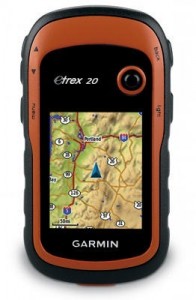
Garmin eTrex 20
The other important thing is getting a receiver that is set up to navigate. Not all GPS receivers can accommodate topo maps. If you’re content with a receiver that won’t let you add detailed maps, check out the Garmin eTrex 10. Otherwise, stick with a mapping unit. Be aware though — most units don’t include detailed maps. Fortunately, there are plenty of free (and legal) topo maps for Garmin units. One other note before we get into the recommendations — you may also find it helpful to check out my Garmin handheld GPS comparison chart.
Budget GPS for hiking
Our choice: Garmin eTrex 20
- Bright color screen
- Can accept detailed topo maps
- Tons of features not previously available on entry level models; if you can swing the price, this is the one to get
Other budget units:
- The Garmin eTrex Venture HC can be significantly cheaper but carries an older, more complex interface, and lacks paperless geocaching and a few other features
- The Garmin eTrex 10 is a new model that has a monochrome screen; you also lose the ability to load maps. The eTrex 10 is available for just under $100 at the time of this update.
Mid-range GPS for hiking
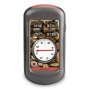
Garmin Oregon 450
Our choice: Garmin Oregon 450
- Touchscreen
- Barometric altimeter and tri-axial electronic compass
- BirdsEye aerial imagery capability
- Garmin custom maps capability
- Advanced track navigation
- This unit has recently been on sale for as low as $185
Alternative mid-range unit:
- The Garmin Dakota 20 is a smaller version of the Oregon. Once its been on the market for awhile, it should start to show up at a discounted and very attractive price.
The top of the line GPS for hikers
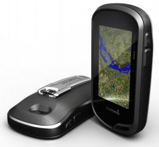
Garmin Oregon 600 series
There are several units to consider here; all have a barometric altimeter and tri-axial electronic compass.
- Garmin Oregon 600 or 650 – The latest and greatest from Garmin, these units offer a capacitive touchscreen and a huge array of customization options. The 650 adds an 8MP geotagging camera.
- Garmin GPSMAP 62s – Perfect for those who don’t want a touch screen unit. It brings all the latest features such as paperless geocaching, BirdsEye aerial imagery, custom maps and advanced track navigation. Step to the 62st for pre-loaded 1:100,000 scale topo maps of the entire US.
- Garmin Montana series – I reviewed the Garmin Montana 600 and have been very impressed with it. Yes, it’s a bit on the big side, but that really didn’t both me much. And it’s the best dual-use unit Garmin has ever offered.
Other high end units:
- Another option is to get a couple of Rino 650 units for you and your outdoor adventure partner. That way, you get most of the advantages of the 62s, plus you can see their position on your screen (and vice versa)!
Related posts


The new Oregon units are pretty sweet and as much as I like my 60Csx, I find that touch screen interface pretty handy. My main gripe against the 450t and the 550t is that preloaded 1:100k scale map. It doesn’t really give enough detail to someone looking to do extended backcountry travel.
I think using the Garmin software is a better idea because (1 a user can put only whatever the maps needed on the GPS; (2 route planning a lot easier on the computer than on the GPS itself and (3 it enables the user to print out a map with the waypoints accurately plotted. Granted, it’s not as convenient as just using the preloaded maps or slipping that little chip into its slot but I feel sometimes convenience is a little overrated.
what is the best map program for oregon 450. i want to geocache and hike trails. im lookng for the best detailed and accurate map thanks much
Get some of the free maps from http://gpsfiledepot.com
i went there and im kinda confused on how to get the maps into the gps. i did go with the oregon 450 over the 60csx, i thought both were very accurate but for me the oregon is much more user friendly, is there a limit to how big of a memory card you can use, what id like to do is have detailed topo maps for the whole united states plus city navigator to get me close to trails or what ever. im the type of person that might wake up on a sat morn and on a whim head out of state, who knows what direction lol and id like to have all i need in one spot insted of predeterminig when im goin and then checking to see if i have maps for that area, any tips or ideas would be much appreciated
also on the oregon 450 is there any way to change the color of the magenta active track line, its very hard to see in sunlight
On loading maps: http://www.gpsfiledepot.com/tutorials/how-to-load-maps-on-my-garmin-gps-unit/
This might help too:
http://gpstracklog.com/2011/05/loading-multiple-maps-to-garmin-devices.html
As far as maximum card size, see H4 here: http://garminoregon.wikispaces.com/Hardware
Alas, I don’t believe there is any way to change the active route line color.
I am looking for a unit that will show me waterfalls to photograph!
Some units with maps loaded will allow you to do this. On my Garmin Oregon 400t, I can do Where To? > Geographic Points > Water Features and then enter FALL as a search term and have them show up. A better approach might be to get a database of coordinates for waterfalls and create a custom Points of Interest (POI) file to load to the unit.
Dear Rich,
Thank you for that informatve & quick reply. I am presently home nursing a broken wrist sustained from my last hiking adventure up a mountain to photograph a waterfall. Jerry Reinlieb
Wow that’s a load of Info!
I was planning to buy my first GPS watch mainly for trekking in jungles
Budget under $300
How intutive/important is the waypoint marker in real world use and how does it work?
Secondly, I believe the Garmin FR110 cannot mark waypoints but the 405 can. But it has the SirfStar IV chipset while the 405 has the older III version.
How quicker/more accurate is the IV over the III??
Thanks in Advance,
Rahul
The Forerunner series is for runners and other folks interested in fitness metrics. It is not a good navigation device. I would urge you to get a real handheld GPS designed for hiking and not a fitness model. Having said that, the Forerunner 305 has some rudimentary navigation features. The 405 has less and I think the 110 has none.
More info on waypoints here…
http://gpstracklog.com/2010/02/handheld-gps-101-waypoints.html
I have yet to test a device with the SiRFstar IV chip.
Dear Rich thanks for the info!
That hurts! i wanted something that i could wear everyday as well.
Your 101 Handheld GPS series is simply awesome!!
Anyway, what’s your suggestion for the best handheld device under $200?
Considering Accuracy, Build quality, Waterproofness, Easy of use, Battery type/life (preferably primaries – AA/AAA) in that order.
Here in India, getting topographical maps is not easy!
Do suggest something that – can create/locate its own maps?
Thanks in advance,
Rahul
The Garmin 60CSx has been seen for that price recently.
I’m not sure what you mean by create / locate its own maps. There is a free one for central India at http://mapcenter.cgpsmapper.com/maplist.php?cnt=102&rgn=&cat=4. You can make your own with a little patience and some computer skills.
Thanks a lot Rich!!
I’ll be walking about three months on both sides of the Pyrenees next year and want to carry a device of some kind that can be loaded with my own route marked Google Maps AND powered or recharged with the appropriate solar panel.
I need the device to work in US AND Europe for all features. The environment will be cold early on and quite hot towards the end. I would like to be able to keep a charge on the device while walking and believe I might be able to do this using a flexible solar panel hooked up to the device’s holster.
ANY and all suggestions with respect to devices, solar panels for recharging, where to find specs that address panel/device compatibility, battery suggestions and thoughts on whether I’d be better off with something other than a GPS (!) will be most welcome! Weight matters,too!
I can’t say anything about solar chargers, though I know they are OK for phones, but the problem I have with my Etrex is that I can’t work out how to use the French maps and the Spanish maps on the same device. As soon as I install a Spanish map it elimintes the Spanish ones! Perhaps you need to have 2 GPSs?
what I meant to say was, as soon as I install the French maps it eliminates the Spanish ones…
With older units, you’ll need to send all the maps to the unit at once. In MapSource, select all the French maps you want, then use the drop down box to switch maps. Select the Spanish maps you want and then send them all to the device in one operation.
Thanks Rich. Sved me a lot of hair-tearing.
Sorry, but I don’t have any experience with solar chargers. To get Google Maps you would need a smartphone rather than a GPS, but battery life and cell reception will likely be problematic.
Hi all
I am looking at the Twonav Sportiva or adventura and the Garmin Oregon 450T for hiking on the east coast of Australia and NZ when I can get there. Any advice on the differences and limitations would be appreciated. The Sportiva and the 450T are about the same price and are probably the two that I would be choosing between. thanks
I haven’t had the opportunity to try the Twonav, so I can’t compare them. Is there an Oregon 450t with preloaded maps for Austrlia/NZ? If not, I’d go with the (non-t) 450.
What happened to the Garmin GPSMAP 60 and 62 models? They are not even discussed here. They are cheaper than the Oregon models and have (?) better reception. For those who do not value the touch screen for the extra $100 they command, aren’t they ‘top of the line’?
You’re absolutely right. When I finished my 62s testing, I updated the handheld buyers guide, and was supposed to update the other guides too. Looks like it slipped off the radar. I should be able to update them this week. Thanks for letting me know!
Done! Onto GPS for bikers!
Thanks for this superb resource.
Have you considered comparing the accuracy of the iPhone GPS (particularly the iPhone4) to a standard handheld device in wilderness applications, e.g. hiking where there is no cell phone reception. I understand most smartphones have a GPS chip which can still work in the wilderness?
I have been eyeing up the Dakota 20 for some time now for hiking purposes. But before I part with $250, I’m also considering upgrading my phone, and wondering whether an iPhone could hit 2 birds with one stone. The question is whether the iPhone and its Apps (many of which seem to add the same features as a good GPS unit) would be accurate enough for backcountry hiking.
Advice is highly appreciated! Or is there perhaps a device similar to the Magellan ToughCase for smartphones, that would upgrade them to give an acceptably accurate GPS, but at a lower price?
You’re welcome!
Since there’s no AT&T serrvice at my house, I’ve avoided the iPhone, though I have tested my Motorola Droid against a handheld, and its pretty close! From what I hear, the iPhone 4 is not as good though.
Regardless of brand, backcountry reception can be an issue, since phones rely on cell towers to assist GPS. Most phones are not as good at getting a lock where there is no cellular access, sometimes to the point of not being able to lock at all without cellular assitance. This article fills in some details…
http://androgeoid.com/2010/09/fixing-some-common-gps-issues-with-android-phones/
Ruggedization is another issue that needs to be addressed. Generally speaking, I would advise against planning to use a mobile phone solution in the backcountry, over a traditional GPS. I expect this to change in the next couple of years, and we should see some hybrid solutions hit the marketplace.
As you note, the ToughCase can resolve this issue, but it is a pricey solution. The Androgeoid blog referenced earlier has been posting recently about Bluetooth GPS solutions that offer another approach, though I’m not sure all apps recognize an external Bluetooth GPS, so beware of that. Hope this helps!
Have a garmin 62s and have downloaded the free Wisconsin Topo and Colorado Topo maps from the website you recommended in your review of the 62s. I download the WI topo to mapsource and also CO topo but when I upload both maps (one at a time) to my 62s, it seems to erase the previous map. IE. I upload a map from WI topo from Mapsource to my GPS and it shows in the maps. Then I upload a map from CO topo from Mapsource and it erases the WI map I had previously uploaded. Is there a way around this? I would like to have multiple maps on my GPS but cannot seem to do it this way. I know I can create a map that includes portions of WI and CO and upload it as one map but would like to upload additional maps in the future without loosing the existing maps in my GPS.
Hope I am making sense. Your reviews and suggestions on how to use my GPS are great, really appreciate all the work you put into your reviews.
Glad to help. Garmin only allows one gmapsupp.img file on the device (though you can also have one on the micro-SD card), but they’ve also given us a nice workaround…
Send one of them to the 62s, then use a file explorer on your computer and go to Garmin\gmapsupp.img. Now rename it something like Garmin\WItopo.img. Rinse and repeat with any other maps you want to add.
Hi Rich,
We have a young man in the family who is really getting into hiking the last couple of years. He mainly does day hikes but is starting to do overnight stuff too. He recently had one occassion where he and his friends got lost. Luckily found someone who gave them a ride back to their car. What’s the best bang for the buck in GPS for someone who could be using it a long time going a lot of places in life?
Are you the Mary K Thompson I know in NC?! Regardless… How old is he? Is he fairly tech-savvy? On the low-end, I’d probably look at the Garmin eTrex Venture HC. If you could spend a bit more, I’d consider the Garmin Oregon 450.
Yep, that’s us. A 16 year old big time hiker wanna be. Will look at your suggestions. Thanks.
Cool! Check those out. I expect the Venture HC will be around $100 on Black Friday, and we may see the Oregon 450 for $250. There are some good free maps at http://gpsfiledepot.com. You should all be aware that there is a bit of a learning curve for handheld GPS. Once he gets it, he should check out this series…
http://gpstracklog.com/handheld-sport-gps/handheld-gps-101
Maybe we can all do a hike together sometime!
Rich, I currently have a garmin 60csx. I am thinking of buying a Delorme pn-60w / spot. I carry my gps in my chest pack while I am backpacking. In this position, the garmin antena is pointing straigt up. On ridge and scrambling routes…the track log is very acurate. My question is, will I get a similar accurate track log with the Delorme pn-60w in this position? I can not carry the delorme “FACE UP” while I am on the go. Is there any truth to the fact that the delorme antena has to be “face up” to be accurate? If so, this will be a deal breaker for me. I already own a SPOT II, so this combination (garmin / spot II) works fine. I just would like the capability of the free-form text message.
Thank You.
Rich
The DeLorme probably uses a patch antenna, and theoretically, this performs better horizontally. This comment might be helpful…
http://gpstracklog.com/2010/10/delorme-pn-60w-with-spot-satellite-communicator-review.html/comment-page-1#comment-104815
You might ask there. Maybe Greg will answer.
In reality, I see little difference in effects from antenna orientation, but I don’t tend to carry units close to my body either (I’m more of a mtn. biker than hiker).
i just got a pn-60 and come to find out there is no way to delete the tracks, so eventually your screen ill be a big ball of green lines, even delorme admitted this in a form. iwent and got a 60csx and a oregon 450 and im goin to see which one i like/ and works the best and send the other back
I’d go with the Oregon 450 over the 60CSx…
http://gpstracklog.com/2011/04/five-reasons-to-upgrade-your-garmin-handheld.html
I’m looking for a budget gps that you can tag locations so you can find them later. Does the garmen etrex hx have this feature? If not, does anyone have a suggestion for one that has this capability?
Thanks
Almost any handheld GPS will. I’d avoid the eTrex H if you want to save waypoints to a computer, due to the serial (non-USB) interface. The Venture HC is much better – USB, you can add free maps, color & better interface.
Current eTrex H deals:
http://bestgpsdeals.net/tag/garmin-etrex-h/
Current Venture HC deals:
http://bestgpsdeals.net/tag/garmin-etrex-venture-hc/
Need suggestions. We forage for mushrooms and would like to a GPS on which we could note, and save, our finds for future years, ie co-ordinates, the type of mushroom, and the date. Is there such an animal at a reasonable price? What would you recommend?
Just about any handheld GPS will allow you to do this. I would go with a newer one, with a high-sensitivity chipset, for better reception under canopy though. You can use the waypoint name to identify type, and there is usually a note field too. The Garmin eTrex Venture HC is a good low end model…
http://gpstracklog.com/2007/08/venture-hc-revi.html
magellan delorme garmin ???
I’m looking for a great, versatile all-around hiking/trekking/climbing GPS. You favorite(s) with a couple pros and cons?
I’d sure appreciate it and thank you for this valuable site!
Garmin GPSMAP 62s or Oregon 450. More info on why to go one way or the other here…
http://gpstracklog.com/2010/07/garmin-gpsmap-62s-or-oregon-450.html
Or the DeLorme PN-60w + SPOT if you’ll be doing solo adventuring, or risky enough stuff that you need it.
You didn’t mention where you’ll be traveling, but if it’s outside the US, that’s another reason to go with a Garmin.
Rich-
I’ve been loaned an Oregon 300 to help get our local trail system on a website. My issue is battery life seems to only last like an hour! Granted it was 20 degrees and snowing out and I had the GPS strapped to my hipbelt on my pack to make sure it had good reception. I have an Etrex Vista that I would turn the compass off to help preserve battery life but I can’t find a way to turn the compass off on the Oregon 300. I could use my Etrex but find that I have to walk with it face up which isn’t exactly handy when you want to hike with poles.
Thanks in advanced for any help you can give me!!!
Shelley
What kind of batteries were you using? These newer units weren’t designed to use alkalines. Most people use rechargeable NiMH. I prefer Eneloops, which can be stored for long periods of time without losing their charge. There is a battery setting, so you could go in and change the type you are using and see if that helps.
It’s funny alkaline is a choice in battery settings on the 300. I was using either Duracell or Energizers-out of convenience. I have some Radio Shack rechargeables will try those to see if they make a difference. Thanks again for your help!
Do all GPS units work with geocaching? I just discovered geocaching and I just bought a bike. I’ll be combining the 2 plus occasionally boating. What would you suggest as a good unit for this type activity?
Generally yes. If you can swing it, I’d go for one with paperless caching capabilities though. What’s your budget?
I might could swing $300.
If you don’t mind not having an electronic compass, the Garmin GPSMAP 78 or 62 would be good choices. But it won’t point towards your destination while standing still; only when moving. But you don’t have to calibrate the compass every time you change batteries either. To spend less, you might want to look at the Garmin Dakota series.
I would recommend the Oregon 450, but glare could be an issue on the water. Check into some of the ones I mentioned and feel free to ask more questions.
I’m using latest Garmin XT on my WM smartphone(build-in gps) with 2008 us topo map. It can’t do turn-by-turn car navigation but that’s ok for me. I want know that does it can accept waypoints for trail navigation and/or preform trail navigation?
Besides, is there any WM/PPC software available that it can accept waypoints and perform trail navigation with custom build map?
i have no experience with XT, but I can tell you that there are lots of WinMo programs available for this. One option is OziExplorer CE.
I’m looking for a GPS unit that is waterproof, small enough to clip to a backpack or to my search dog (so I can monitor his activity during training), and can download to a computer. I tried the freedom GPS keychain device but it’s not waterproof enough and I can’t get the data from the unit via the USB (it’s for charging only) and my cell phone won’t connet via the Bluetooth so it’s useless to me.
Now I’m debating between the Garmin GTU 10 GPS Tracking Unit which requires an annual cell service fee or the Track Stick for $100 more but does not require a service fee. Anyone have any advice on this?
I haven’t been able to test the GTU-10 yet, but I am planning to. This may help…
http://gpsinformation.info/penrod/GTU/gtu.html
The Track Stick won’t let you do live monitoring.
Hi, love your site. Stumbled upon it while looking for a good replacement for my dying 8 year old e-trex. I am from Trinidad and Tobago in the Caribbean and do a lot of sea kayaking. I was truly impressed by the Delorme PN60w/Spot Combo review, because I do a lot of solo sea kayaking /surfsking and nearly got pushed out into the Caribbean Sea this weekend 🙁 However, because of the need for a clear sky, water proofing and US Credit Card issues with the Spot Comm, I am looking at other options. I need a portable GPS that would withstand serious saltwater. I am inclined to the Garmin 78 or Forerunner. I prefer a push button rather than a touch screen. My experiences with touch screens are that they sometimes don’t respond to wet fingertips and I might put it in a dry bag for extra protection which could interfere with the ‘touch’ functions. I am torn between a Handheld and a Sport. I believe a handheld would have greater signal reception than a Sport. Am I right? Any advice at this point would be worthwhile. Hey, maybe you can expand your GPS reviews to include kayaking. No one else on the Net has.
I don’t know how much difference you’d see between a Forerunner and a handheld. I suspect it wouldn’t be much though.
Re: open sky for the DeLorme/SPOT – I don’t think cloud cover would matter.
Garmin handheld touchscreens are all resistive, rather than capacitive, so water may not matter that much.
Hmm, just wet down my Oregon 450 for a quick test, and I’d say it is slightly to somewhat less responsive when wet.
The 78s is a very nice unit BTW.
Hope this helps.
Wow. That was a speedy response! With respect to the SPOT Comm, wasn’t thinking about the cloud cover, rather mounting it within the kayak’s hull for protection, but I guess I could dry bag it and mount it on deck if it can withstand the tropical heat. May just contact SPOT and hear what is their take on it.
If you were going to choose for a similar scenario, would you choose Handheld or Sport? I’m partial to a Handheld even though the other guys use Sport models. Which do you think would be sturdier and more waterproof? Sorry to be such a bother.
I have a Garmin Forerunner-it’s great for seeing where I’ve been-downloaded into Topo or Google Earth. I’m not sure I’d want to navigate off the small screen.
I just recently have used a Garmin Oregon 300-it has a touch screen. Nice handheld but horrible in cold weather to get the screen to react to my fingertips. Plus enter waypoints by name I get a lot of typos with the touch screen where you wouldn’t with the older Etrex providing you pushed the toggle in the correct place.
Both the Forerunner and Oregon lock on well to satellites and both show me in the sameplace at the sametime!
Yeah, I’d ask SPOT. The kayak hull shouldn’t interfere with GPS reception, but I don’t know about SPOT transmissions. If it were me, I’d go for a handheld. No bother, BTW. We’re here to help.
Thanks Owen. Still digging for a GPS that would suit my needs and was looking at the Foretrex 401. As I live in Trinidad and Tobago and I am using it for sea kayaking, I wouldn’t need any maps. What do you think about this model?
If you don’t want maps, that would be fine. But there are some free maps for your area…
http://rwsmaps.griffel.se/
Thanks Mr. Owen. You are a real treasure house of GPS info. Still, I’ll be out on the sea mostly. I think I’ve made up my mind: the Foretrex 401. Thanks again for all your help.
Glad to help. If you get a chance, let us know how it goes.
An update – I got my Fortrex 401 back in May 2011, but didn’t get time to test it on the water until July. Still, I was wary about the ‘waterproofability’ of the small rubber tab used over the USB port access area and I put it in a small wallet-sized Kwiktek Dry Pak. The dry pak failed on more than one occassion and the Foretrex spent many hours submerged in sea water. It handled it beautifully. Other comments: the screen, though small, as expected, has large digital numbers for speed display which is great as I need to fasten it way past my feet on the surfski. It is a nifty little device and has dropped from my hand onto a tiled floor without any damage. I would recommend it to anyone not needing maps. It’s perfect for kayak racing and testing speed and then comparing results on Garmin Connect. Very good value for price.
AFAIK, the rubber plugs on all of Garmin’s outdoor units are just there to keep crud out of the connector. The entire USB port is physically isolated from the interior of the unit, and water can’t get inside even if the plug is open.
Boyd, That is nice to know, Thanks. But just wondering, wouldn’t the salt water seepage into the USB Port interfere with the electronics?
Dexter – that was my point… the entire USB assembly is completely isolated from the “electronics”. Salt water can’t get inside the GPS case, just into the hole where the plug goes.
Yes, I can imagine that salt could corrode the connections in there. Don’t know how much of an issue that really is though. You could always flush it out periodically with some fresh water if you’re concerned.
Boyd, Thanks for the update, when I meant intefere with the electronics, I meant the saltwater creating a circuit of sorts between the USB connections. I guess I was just paranoid. Will try iot without the dry pak. It will be so much mor convenient to attach to my surfski 🙂
As we say in Trinidad – Later (means Bye).
I’m a horseback rider and am looking for a GPS to keep track of where I’m going and where I’ve been. Also when I return home I’d like to down load my recent trail ride and print out a map for use at a later time. Thanks for any advice you can share.
Almost any handheld GPS receiver will help you navigate to where you want to go. Most will also record tracks, which you can then download to a mapping program on your computer.
This series might help…
http://gpstracklog.com/category/handheld-sport-gps/handheld-gps-101
At the low end, I’d recommend this unit… http://gpstracklog.com/2007/08/venture-hc-revi.html
For a more feature rich model, one of these… http://gpstracklog.com/2010/07/garmin-gpsmap-62s-or-oregon-450.html
For printing maps with your tracks and waypoints on them, I prefer the National Geographic TOPO state series (for Windows users).
Hope this helps.
Hi,
Great site w/great info! I am looking for recommendations on a Hikers GPS.. My (soon to be) 60 year old Mother is an avid Hiker, and really needs a solid, dependable device. Would need to be easy to use, easy to upgrade/update, probably touchscreen with an altimeter, topo, etc, etc. I don’t have a strict price-point in mind.. I just want something that will guide her (and ease our minds) when she’s off hiking. Thank you!
Is she technologically savvy? Handheld GPS receivers definitely have a learning curve. A Garmin Oregon 450 or 450t might be good choices.
Thank you for your quick reply!
Yes, she is moderately tech-savvy.. I believe she has a Garmin Nav/GPS in her car, so she is vaguely familiar with their interface and menu system already. I appreciate the suggestions.
Handhelds are much more complex than auto units, but it sounds like she’ll be able to handle it. I’d say the Garmin Oregon 450 or maybe the Garmin GPSMAP 62s. Both are great units. They are the two most popular models with our readers right now. Some info here (http://gpstracklog.com/2010/07/garmin-gpsmap-62s-or-oregon-450.html) but whichever you can find cheaper (likely the 450, which is significantly lighter weight too) might be the way to go.
You could get the 450t or 62st instead, which come with preloaded 1:100K scale topo maps, but she can get more detailed 1:24K scale maps for free at http://gpsfiledepot.com.
I’d suggest she spend some time reading this series…
http://gpstracklog.com/category/handheld-sport-gps/handheld-gps-101
And if she has any questions, we’re here to help.
I am setting out on the Pacific Crest Trail, much of which is under snow and hard to follow. I am looking for a unit into which I can load a trail map with way points. I’m not real good with tec stuff so simplisity of operation is a pluss as is weight. Thanks
Hi Amanda. Unfortunately, handheld GPS are pretty complex beasts. Much more so than auto units. How long will you be out? You’d do good to get a full day out of most units on a single set of batteries.
I have a Garmin eMap. It is in great shape and I have all the accessories, external antenna, bike mount, memory card reader, data cables and all. Am I still stuck with the old Topo and US maps that Garmin released for the eMap and eTrex or can I download Google maps and some of the public domain maps to this device. Or, is this device archaic an in need of donation to the Smithsonian? For driving directions and such I have my iPhone and an old iPaq 2200 with the Tom Tom maps and external GPS so the eMap is only for outdoor stuff although in typing this it is painfully evident how dated my collection of GPS toys is….
Thanks!
Yep, time to upgrade. You can then add other imagery via Garmin custom maps (though there are often easier or better alternatives for aerial imagery and USGS maps). More info here
http://gpstracklog.com/2011/04/five-reasons-to-upgrade-your-garmin-handheld.html
And a sixth reason…
http://gpstracklog.com/2011/05/garmin-birdseye-topo-us-and-canada.html
I conduct fieldwork in some remote parts of the West, and I need to know if any of the Garmin products have technology like a SPOT gps unit? My manager wants us to be able to send a distress signal or test if necessary. Thanks!
No. Not yet anyway. I’d suggest the SPOT Connect…
http://gpstracklog.com/2011/05/spot-connect-review.html
or the forthcoming DeLorme inReach…
http://gpstracklog.com/tag/delorme-inreach
But these solutions would presume you had a smartphone (Android only for the latter). Otherwise, check out the DeLorme PN-60w + SPOT…
http://gpstracklog.com/2010/10/delorme-pn-60w-with-spot-satellite-communicator-review.html
Rich
I do a lot of fly fishing where i have to hike into remote spots in the mountains in the southeast and Colorado. I’m also looking to do some hiking in Hawaii in a few weeks. Any suggestions of what would be a good solution to get me to mountain streams and to some nice spots during general hiking.
Thanks
Before I give a recommendation, I need a bit more info. Is this your first handheld (vs. car) GPS? And do you have a budget in mind? In the interim, you might also want to check out this post…
http://gpstracklog.com/buyers-guides/handheld-gps-buyers-guide
Yes first non-car GPS, do have topo map reading experience and certainly not technology challenged. What I was looking for is a device to take fishing/hiking specifically, I have a car model. Back country mountain streams are the favorite, finding the headwaters and getting back out is often the challenge. Would like to take the worry out of knowing where I end up after working a stream hard and be able to mark the “good” spots for the next trip.
Screen resolution, ability to load maps, ruggedness are all important. I’ve been looking at the Oregon 450t so that would be the price range I think would be right.
Thank you for the time and response.
You should be in good shape, but handheld units definitely have a bigger learning curve. This series should help…
http://gpstracklog.com/category/handheld-sport-gps/handheld-gps-101
I’d consider the Oregon 450m instead of the 450t. The 1:100k maps on the 450t aren’t very detailed, and you can get great 1:24k scale maps for free from http://gpsfiledepot.com.
Let me know if you have any other questions. We’re here to help!
Last question before I make the purchase.
I read your review on the DeLorme PN-60w and liked the idea of having the “spot” available. Safety is always in the back of my mind as I’m crawling over rocks and through streams in areas where my cellphone doesn’t work. What would I give up other than touch screen and screen size by going with the DeLorme? It looked like your review was pretty strong on that unit also.
Thanks again for the help, I really appreciate it.
Screen size is the biggie. Battery life may be less too. I find Garmin units to be a bit more intuitive, but the DeLorme software is what’s really unintuitive.
Do you have a smartphone and, if so, what kind? There are some other SPOT solutions available or coming that may work well for you…
http://gpstracklog.com/2011/05/spot-connect-review.html (seems to work a bit better with Android phones according to the comments.)
Or you could just go with a standalone SPOT II (no smartphone required).
Thanks again Rich
I have an Iphone and never though about the spot as a standalone. But that makes the most sense, I’m heading off to get the Garmin. Thanks
You’re welcome!
@Bob, what you can do is set the map to not show shaded relief and turn land cover off. That should improve visibility dramatically.
I have a Garmin Vista and I dont know how the tracking feature works.
I have read the blurp in the book more than a few times and I still dont get it.
Does it start tracking as soon as you turn it on and start walking?
Do I have to put in waypoints along the way or just continue to my destination?
How do I save the track so I can get back to where I started?
Does it track back in a straight line or does it show every turn as I walked?
Once i save it will it stay in the GPS memory till I delete it?
Thanks for your help in advance.
It starts recording your track as soon as it locks onto satellites, unless you have disabled tracking.
You do not have to add any waypoints, though it does help to have one for your destination.
Which Vista do you have? The original or the Vista HCx? Let me know and I can try to find out how to start a “trackback.” Trackbacks show all your turns.
I think saving it depends on the unit and your settings. Yes, it should save it, but it may truncate it to 250 points.
This series may help BTW…
http://gpstracklog.com/category/handheld-sport-gps/handheld-gps-101
My son is 16 and looking for a hand held GPS for hiking do you have any suggestions for a good starter system.
Depends on how much you want to spend. The eTrex 20 would be the best entry-level model, but it’s still $150. There are a lot of significant compromises below that level, but let me know and I’ll try to help…
http://bestgpsdeals.net/garmin-etrex-20-and-montana-650t-at-ems/1366/
looking for a handheld unit as a gift for my boyfriend… we’re avid hikers, but don’t need anything too complex as it’s our first unit… and most importantly want a mac-friendly device. nothing too expensive since, like i said, we’re newbies w/ the handhelds. suggestions?
If you can swing it, go for an eTrex 20. Here’s a great deal…
http://bestgpsdeals.net/garmin-etrex-20-and-montana-650t-at-ems/1366/
It is much more user friendly than older style units and has a number of new features…
http://gpstracklog.com/2011/04/five-reasons-to-upgrade-your-garmin-handheld.html
I use one with my MacBook Air. Works fine.
Here’s my review…
http://gpstracklog.com/2011/10/garmin-etrex-20-review.html
Also, let me add, that handheld GPS receivers are inherently complex, but these newer models have a somewhat easier learning curve.
awesome. thanks for the quick response.. he has a macbook pro so should work! thanks!
Cool. Be sure to check out our handheld GPS 101 series…
http://gpstracklog.com/category/handheld-sport-gps/handheld-gps-101
And remember, we’re here to help!
If I buy a Garmin nüvi 50 for my car (5 inch screen) can this be used while I hike and bike? Thanks, I’m new at this.
Yes, but it’s not ideal. And it’s not ruggedized or waterproof. This may help…
http://gpstracklog.com/2009/04/dual-use-gps-for-road-and-trail.html
The short answer is that unless you want to spend $500+, most people find it better to have two separate units.
Thanks VERY much. Great link resource. Appreciate your prompt reply. Mike
I work for DoD in Germany. I have been taking short hikes with the Trails App in Germany for about a year and it’s great here with my iPhone service and a backup battery. The Trails App information is clear, accurate and easy for a novice to follow..just follow the dashed line.
I’m now venturing into France and much longer hikes. I’ve been researching and I think the Oregon 450 is for me, at 269.95 at Amazon.com. No need for the 450t US maps and the 450t with Europe maps is nearly twice the price of the 450t with Europe maps everywhere I’ve looked (not available except on UK sites like Amazon UK. So I’ll have to settle for the World maps that come with the 450 I can purchase at Amazon US.
The French topo maps are VERY expensive…400 dollars for France! The GPSFiles Depot with the hiking filter on shows no maps.
I haven’t seen a handheld gps and my main concern is that the maps will just be topo without the easy to follow trails (dashed lines) that I see the in the iPhone App.
So my question is the information provided on the World maps that come with the 450 Oregon similar to that I see in the Trails App?
Wow, the Garmin topo France map sure is expensive! I have no experience with it, however you can view it online to see if it has the trails and roads that you want:
http://www8.garmin.com/cgi-bin/mapgen/webmap.cgi?p=25559041&l=0&u=1&v=0&cp=74EB562356A2658C&z=6&x=300&y=225&w=600&h=450&d=2&rz=0&k=1&sc=1
The basemap that comes with the Oregon is not likely to show any trails at all. In fact, it will not even have very many roads. It’s very low resolution and only shows the largest roads, bodies of water and political boundaries. It has DEM data to produce shaded terrain, but that is also very low resolution. It just provides a very rough representation of the world, and is pretty useless for any kind of hiking or exploration.
Yes the Topo France maps are expensive relative to some other GPS maps, but they do have paths marked, particularly long-distance paths – see http://www.la-rose-des-vents.fr/gps-randonnee-topo-alpes.php for some screenshots (at bottom of page).
Jack,
This website is dated so I’m not sure all the links work, but there are URLs for the sites that hosted the topo maps in some cases…
http://mapcenter.cgpsmapper.com/maplist.php?cnt=73&rgn=&cat=4
For trails, you might want to look at online track/.gpx sharing sites such as Garmin Connect.
Wikiloc is good for France http://www.wikiloc.com, particularly for the Pyrenees (long distance path GR 10).
The feedback on the poor quality of the World Topo included with the 450t (US Topo) is most useful. Perhaps the 450t (European Topo) is worth the the cost in my case.
Again, go to Garmin’s site and look through the maps section to find the version you are interested in. You will be able to view the maps for yourself on the website. In the US, the 450t pre-loaded maps are the 100k US Topo’s.
I have experience with Garmin GPS units. I started with an eTrex Vista several years ago and now own a 60CS. The 60CS loses signal very easily and now it is always turning off no matter how new the batteries are. I’m thinking it is time to upgrade. I am trying to decide what to get next. I do a lot of hiking, some bushwhacking, backpacking and long distance hiking. I hope to hike either the PCT or CDT in 2013. I realize I can do most of what I need with my Android phone, but as you have mentioned, phones are not durable enough to rely on for this and the battery does not last. Do you know if there are plans to integrate the functions for a back country phone/camera/gps/personal tracking/SOS capability with durability and use of AA batteries? I know, wishful thinking. I am looking for a GPS that has highly reliable reception and reasonably accurate. Any suggestions?
There’s nothing that I know of, but there are ruggedized phones and solar chargers.
Although it won’t meet all of your needs, you might want to look at the eTrex 20 or 30, which are lightweight, with long battery life and have the newer Garmin features…
http://gpstracklog.com/2011/04/five-reasons-to-upgrade-your-garmin-handheld.html
I have just recieved an Etrex 10 for Christmas from my girlfriend. I have never had a GPS system before, so I rather unsure what to do next. I know that this model does not support detailed maps, and I do not know how and where to download calculated routes to download onto my GPS. I need someone to explain everything to me and hopefully tell me where I can find these existing waypoint routes. We usually go walking in the lakes and enjoy climbing mountains like skiddaw and scafell etc. All i want is to be able to get info onto my gps so that I can walk routes safely and so that I know where I am going!
Congrats Gareth. I think you’ll really like it. If you didn’t see it, I’d check out this article…
http://gpstracklog.com/2011/12/a-bakers-dozen-tips-for-your-new-handheld-gps.html
and this series…
http://gpstracklog.com/category/handheld-sport-gps/handheld-gps-101
One option you have is to search the Web for .gpx files for whatever park, hike or trail you are interested in. I just searched for “gpx skiddaw” without the quotation marks and came up with quite a few files to download. These go into the unit’s GPX folder (just drag and drop them). Some will contain tracks (sort of like trails), while others will have waypoints too.
There are also numerous mapping software options that will let you place a waypoint on a map or aerial photo on your computer and then transfer the waypoint to your eTrex.
Hopefully that is enough to get you started. Feel free to chime in with more questions. Have fun!
Thank you for the very helpful response. However, would you be able to elaborate on the mapping software options please? I have spent all day trying to find a way to get a map, upon which I can create my own routes, with no luck! I know I must sound like a total fool, but I just cant seem to get to grips with all of this!
I’m not that familiar with what the options are for the UK. You can try TopoFusion, but I don;’t know what sort of UK maps you’ll find.
You can probably load these into Garmin’s free BaseCamp program…
http://talkytoaster.info/ukmaps.htm
Or you may just want to ask here…
http://www.gpspassion.com/forumsen/forum.asp?FORUM_ID=4
Hi,
I am a mountaineer and regularly visit Indian and Nepal Himalayas. Can anyone suggest a GPS tracking unit that would track my progress and keep my family informed as to where am I? I already have Garmin Oregon 450 but what I am looking for a GPS unit that would transmit my location real time to my family.
Some people in this forum have suggested Spot. However, as per their website it doesn’t have coverage in India and Nepal.
Would appreciate if someone can help me.
Cheers
The DeLorme inReach, paired with the DeLorme PN-60w, is probably your best bet, but it is a bulky solution. I should have an InReach for Android review posted within a month.
http://gpstracklog.com/tag/delorme-inreach
hey rich,
it’s great to see you taking the time to respond to everyone’s comments.
i’m here in the US and primarily would like a GPS unit to help me find water springs, usually i have the coordinates and a google-maps idea of the vicinity, but would like something to help me pinpoint the springs out in the field. often these are in rural areas, accessible by small roads into the area, then it’s up to me from there.
i also hike often, but have never owned a GPS before, so it would just be an extra tool for that.
looking in the lower- to mid- price range area.
any suggestions?
thanks!
I’d look at the eTrex 20 or Oregon 450.
If you are looking for hot springs, there are plenty of points of interest (POI) files that can be added to the GPS for those. There are less of these available for other types of springs.
Some of the free topo maps at http://gpsfiledepot.com have searchable water features and some don’t. The Garmin 24K maps do, but they only turn up named springs.
You may find this series helpful BTW…
http://gpstracklog.com/category/handheld-sport-gps/handheld-gps-101
And you may find mapping software useful. It would allow you to (on your computer) create waypoints for springs based on USGS maps and transfer those to your GPS. Hmm, guess I should add a mapping software post to my handheld GPS 101 series!
Hi Rich, I have a Garmin Edge 800 and would like topos that show shaded relief. I am a road biker and would like to beable to see detailed topo so I can see hill grades etc while I bike. Do the Garmin Topo’s work well for this? Hate to spend the money on them if there is something equally good out there.
Thanks.
I’d go for some of the free maps at http://gpsfiledepot.com instead. You’ll probably be able to tell a lot more by just having contour lines displayed.
But yes, the newer Garmin 24K maps would show shaded relief too…
http://gpstracklog.com/2011/06/garmin-topo-us-24k-review.html
I am interested in a gps unit in a few months, it would be my first purchase. I am an avid hiker and backpacker and am moving to another part of the country and want to try my hand at some kayak fishing as well (as opposed to just going for trout around here). I will probably post some questions, I am looking at the garmin oregon/montana and the gpsmap units with the high fidelity receivers, but haven’t decided on touch screen (I assume their battery life is weaker) or the gpsmap units.
I wanted to thank you for this site and all the helpful comments, sure got some reading and researching to do.
Cool! We’re here to help.
Two other options come to mind…
The (unfortunately pricey) 78s, because it floats…
http://gpstracklog.com/2010/06/garmin-gpsmap-78s-review.html
The eTrex 20/30 have a 25 hour battery life rating, which I bring up since you mentioned backpacking.
The only other comment right now is that touch screens may be harder to see on open water where there is a lot of sunlight and glare.
Thanks
I am looking at the Gpsmap 62s. I don’t need a camera and the maps can be loaded separate. I noticed in your review of the 78 you mentioned the accuracy is diminished by holding the unit upright.
Is this true for the 62 models? The etrex seem nice, but I figure if I am spending the dough for a nice gps, might as well spend an extra $100 and get exactly what I want. The additional bit of battery life is nice, but the 62 gets 20 hrs I see using AA’s just like my headlamps so thats a good thing.
On a side note, I am also looking at lowrance, they have a cheaper price point but while they seem to have a good map service, it just doesnt seem as user friendly as the garmin. Their spot contract/tie up whatever is cool too.
The 62s probably has a quad helix antenna, which should make it work beter upright than horizontally. I haven’t noticed any difference in mine due to orientation though.
I’d stay away from Lowrance.
My old Garmin wristheld just broke, and I need my new GPS to do a couple of fancier tricks than the old one did. Mainly, I need the ability to download topo maps with the route outlined onto my computer. I actually don’t care whether the maps are built into the device, or whether I can download the route onto my National Geographic TOPO! software.
It would be even cooler if I could stop at points along the way and input attractions along the route that would then be automatically placed on the map. But that’s not necessary.
I do love my wristheld instead of a handheld, but realize this might not be doable. Any suggestions?
You can import a track file into NG TOPO, but not a .gpx route file. I’d encourage you to seriously consider a handheld, perhaps the eTrex 20. These are some of the features you’d be getting with newer models like that…
http://gpstracklog.com/2011/04/five-reasons-to-upgrade-your-garmin-handheld.html