Sunday, March 18, 2012

GolfNow Launches Premium Golf App with GPS

New-GolfNow-Mobile-App-Premium-Version

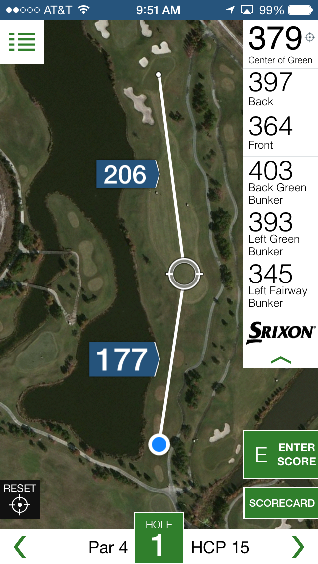
GolfNow, the popular golfing technology platform, has launched their new GolfNow app for both Android and iPhone. The free version of the app allows for tee-time reservations and booking along with some basic information about prices, time and rating.

However, for the serious golf enthusiast, the premium app adds some pretty nifty features like golf course mapping. The premium version of the app costs $29.99 for a year subscription and allows access to more than 5,000 courses in the US and a few international courses as well. It might be a little pricey, but if you golf a lot I can see how it would be totally worth the money. read more

App Gives GPS Guides to Alabama State Parks

pocket ranger app logo

In honor of the Alabama Park System’s 75th Anniversary, a new app has been released that will give users comprehensive guides to all state parks in Alabama in one app. The Alabama State Parks Pocket Ranger app joins a suite of apps mapping out state parks, fishing guides, hunting guides and more for nearly 30 states. These apps provide not only a wonderful tool for exploring your state parks, but they are all free on iTunes and Google Play. Just search “Pocket Ranger” with your state name. read more

Waze Updates Allows Geotagging, Parking Reminders

Google acquires Waze

Waze, the popular social mapping program, got an update last week that introduced a set of features called “Places.” This feature allows users to add POIs to their Waze app to mark fun and interesting places that they find while traveling. In addition to information about POIs, users can add photos to help others know they are in the right place. Sounds an awful lot like the popular waymarking pastime, except instead of a scavenger hunt to try and find places, you can actually get directions there. read more

Discover Wyoming’s Stories with New GPS App

travelstorys

Down every road and through every terrain there are stories waiting to be told of the people who once lived there. It isn’t hard to imagine as you are walking through the countryside of Wyoming that the 17th century landscape wasn’t all that different. But who has time to go through all of the research about a stretch of road?

Introducing the Travel Storys GPS app, a multi-platform app that is designed to do just that. read more

GPS & Augmented Reality Show Berlin Wall History

time traveler AR

Through augmented reality, you can see what Berlin was like when the Berlin Wall was built.

There is nothing I enjoy more than seeing GPS used in unusual and creative ways. Recently, a German company has created a TimeTraveler app that allows visitors to learn about the Berlin Wall through GPS-based augmented reality. Available on both iPhone and Android devices, this cool app lets your phone act like a window to the past. read more

Bike+ App Does More Than GPS

BikePlusAppImage1 A bike ride isn’t just GPS and ride statistics like distance, duration and elevation—a bike ride is about an experience. Most cycling apps and devices are so busy with the statistical data that they don’t leave time to capture the actual experience of the ride. So, world champion bikers James Mathis and Ted Huang created their own app to do just that. read more

Can You Use GPS to Avoid the Flu?

sickweather screenshotThere are all kinds of apps for your smartphone that are designed to use GPS to help improve our lives. Some of them are incredibly useful, and others…well, they are mostly just odd. Joining the ranks of odd (and slightly creepy) apps is the app Sickweather.

The idea behind Sickweather is to map out places where people are sick by scanning social media like Facebook and Twitter for people posting they aren’t feeling well, and then using GPS to see where they are. The app then puts it on a map so you can see where the sick reports are and follow trends of illnesses. That’s the idea, anyway. And while the theory sounds kind of useful, when you stop and think about it… well, it isn’t. read more

Texas Hunting and Fishing App Available Now

outdoor annual

Every year, hunting and fishing regulations change a little bit, and it can be easy to remember the wordy regulations, rules, limits and public locations. But now, if you hunt and fish in Texas, you don’t have to.

The Texas Park and Wildlife Department (TWPD) has released an official app, called the Outdoor Annual with all of the information that Texan hunters and fishers need to know for the 2014 – 2015 seasons.

The app is free to download on iTunes, Amazon or Google Play. The list of information the app can supply you with is extensive and includes licenses, aid in finding public hunting/fishing locations and identifying fish/wildlife.

Here’s a breakdown of what the app does: read more

New App Uses GPS to Save Lives

The first few minutes in an emergency are crucial and sometimes ambulances and emergency personnel just can’t get there in time. But, if you live in a city, the chances are you are never more than 500 feet from someone who could help and maybe even save your life during an emergency.

That’s the concept behind a new GPS-enabled smartphone app, GoodSAM (or Good Smartphone Activated Medics). It’s currently available for both iOS and Android. There are actually two different apps for this program: one for responders and one for everyone else. read more

Hiking App Helps Locate Most Beautiful Spots

Stand Here

Stand Here photo

As you reach the top of the hill, you see the sun turn the leaves of the trees to tiny emeralds. The filtered light illuminates the cool waterfall ahead with the magnificent warm-colored stones worn smooth from the water and for a moment, your breath catches as you gaze at this perfect spot. There is nothing quite like the natural beauty of the wilderness, and such sights are the reason and reward for many hikers who explore the wild areas of the world. While sometimes the best views are found by accident, others are not.

Introducing the Stand Here app, a hiking companion app designed to help hikers find and protect the most fantastic spots in the world. Available only on iTunes, the app is free and includes a number of functions to help hikers find their ways to the most wondrous spots in the U.S. and track their way safely back. Created by acclaimed photographer Rodney Lough Jr., the app has been about six years in the making  and was released on August 8, 2014.

“The goal is to identify beautiful places, help educate people on why they are special and get people to stop and stand there. To have that moment of awe that takes your breath away,” Lough said. “Then we can understand why we need to protect these places.”

read more