Sunday, March 18, 2012

GPS Tracking App Helps Veterans

pos-rep-logo


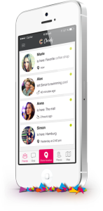
In the wake of social GPS apps like Tinder and Grindr, two veterans have created an app designed to help veterans locate and contact other veterans they served with or veterans simply in the same area. Dubbed Position Report or POS REP for short, the app is designed to prevent returning veterans from feeling alone and without resources. The app is available for iPhone with Android support coming soon. There are no plans for a desktop version. In addition, the app is restricted to veterans–not veteran supporters or civilians. read more

Hertz Launches NeverLost Companion App

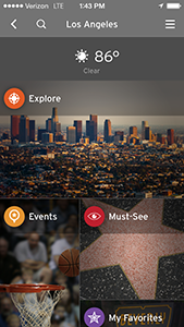
hnc_companion02Hertz and Navigation Solutions have announced the launch of an app to complement their NeverLost GPS Navigation System. The new app, NeverLost Companion, is a travel app designed to seamlessly integrate with their GPS systems and provide travel information and POIs and events or more than 40 cities in the U.S.

The app is run through your Android or iOS smartphone. When you open the app, you can pick a city and then browse through popular locations, local events, sports venues, parks, neighborhood details, tour information and more. You can share your trip with Facebook/Twitter integration and save your favorite locations and cities to get back to them quickly when you travel. Once you have discovered new places, you can then sync the app to your Hertz NeverLost GPS Navigation System and get instant directions there. read more

Foursquare Tracks Your GPS Location Constantly

foursquareGPS apps use location data in a wide variety of ways—from helping you connect with friends to remembering where you parked your car. As these sorts of apps have become more and more common, the general public has started to be a little more wary of who is able to keep track of their exact GPS coordinates. Foursquare, the popular app that allows users to find new places in their cities by leaving and reading reviews. This, of course, means that foursquare has to keep track of where you are so it can leave a note on the map for other users. Now, with a new update, Foursquare not only keeps track of where you are while in the app—it tracks your location even when the app is closed.

For example, if you frequent a sushi place in your hometown, Foursquare will store that information and when you travel, it will send push notifications letting you know about good sushi places in new towns when you travel. That doesn’t sound too bad, right? I mean, who doesn’t love finding new places? Until you start thinking about it. I mean, we take our phones with us everywhere. That’s a whole lot of potential information that Foursquare has decided to cash in on.  read more

Use GPS To Unlock Secret Messages

TracesIn the digital age, it seems like people have become more and more detached from each other as social media and messaging becomes more and more common. A new app, called Traces, is trying to change that with an immersive messaging system that uses GPS location and augmented reality to force users to get out of the computer chair and go and find messages from friends. Half treasure hunt, half phone messenger, Traces is a really unique and awesome use of GPS technology that I just had to share.

“Facebook and WhatsApp broadcast frequent, out-of-context information that’s of very little value to you, leaving you a completely passive receiver,” said Beau Lotto, CEO of Ripple Inc, based in San Francisco, which created Traces. “Instead of reading tweets in a random location you can choose the location to add context to your delivery,” Lotto said. read more

Affordable App Keeps Hikers Safe On the Trail

logoHeader

When you are hiking or camping in remote locations the first and most important rule is to let someone know where you will be and when you’ll be back. It’s a good idea to have some sort of distress beacon to send out your GPS coordinates in case the unthinkable happens, but if you are on a budget, those GPS distress signals can take a mighty chunk out of your wallet. So, why not just use your cell phone as a beacon?

The web-based application HikerAlert is designed to do just that. Before you leave for your trip, you can give it some of your information along with your intended travel route and return time. If you don’t check in with HikerAlert after your scheduled return time and date, it will automatically send an email and text message to your listed emergency contacts with all the information they would need to relay to emergency response personnel including GPS location, route and equipment information, etc. read more

New App Takes Some Creepiness Out of Location Sharing

closely_app_iphoneThe idea of being tracked in real time and sharing that information constantly with people is more than a little stalkerish and very creepy. A new Android app called Closely is looking to remove the creepy factor from location sharing and tracking. Created by the German company Familonet, Closely is an app designed for small groups to easily keep in contact with each other and share specific location information using a combination of GPS, Wifi, cell tower triangulation and algorithms to determine location.

Unlike most other apps of this nature, Closely integrates with Facebook to allow you to find your friends easily. Once downloaded, you can send invites to contacts to similarly download the app and create a ‘group.’ The app will only shares information with people in your group and only locations you have set as acceptable via geofencing. So it isn’t going to be tracking you every second and will simply send automatic messages to your group when you enter or leave predetermined areas like school, work or a favorite meeting place. The app also allows for chat and pictures to be shared within the group.

read more

Memory-Map Releases Android GPS for UK

Introducing Memory-Map GPS TX3, the newest smartphone/GPS hybrid for the UK

Introducing Memory-Map GPS TX3, the newest smartphone/GPS hybrid for the UK

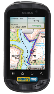
Half smartphone, half GPS, the Memory-Map Android GPS TX3 does a little bit of everything with a rugged rating that will make the most adventurous spirits jealous. Unfortunately, it’s only available for the UK region, but the idea is kind of awesome, so I thought I’d include it in case we have any readers ‘across the pond’ so to speak. Seems about time someone thought to add an actual GPS chip inside a smartphone… read more

Sygic Debuts Navigation App With Dash Cam

sygic blackbox

Why pay for an expensive dash camera that will take up yet more space on your dash when you can just use your phone to record accidents and incidents? I certainly can’t think of a reason, and now Sygic GPS Navigation users can do just that with Sygic’s new BlackBox app.

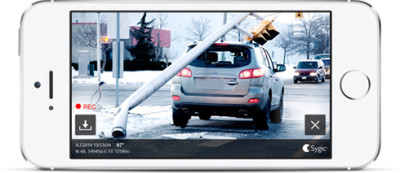
This new add on application uses your phone’s camera as a dash cam and works simultaneously with Sygic GPS Navigation for iOS. The interface for BlackBox is pretty straightforward: You turn on the feature and then mount your phone to a dashboard mount and start driving. The app will record the view from your vehicle in a continuous loop with embedded GPS coordinates, speed, time and date. read more

Sygic Maps Celebrates 55 Million Users With Sale

sygicGPSNavigationandMapsAppProvided you are willing to fork out the money, Sygic is one of the better navigation and mapping applications for your smartphone available. Normally, I would say that the price is a little prohibitive for most but if you have been eyeing this application, then this might be your lucky day.

Sygic is celebrating reaching the 55 million user benchmark by having a 55% off sale on their World maps (marking them from $125.99 down to $55.99). While it’s still a chunk of change, if you find yourself travelling a lot, then it might just be worth the money, especially with such a hefty discount. Many of their regional maps are also reduced by 50% in honor of this landmark achievement. According to their site, this discount will be available until October. read more

Endomondo App Syncs with Pebble Watches

ENDOMONDO LOGO

Endomondo, the popular social fitness network, has introduced a new smartphone app that syncs with Pebble and helps users meet their fitness goals. This free app from Endomondo allows users to start, pause or stop a workout while exercising and can display up to three configurable data metrics, such as distance traveled, heart rate and workout duration – making it one of the most advanced fitness tracking apps for Pebble.  Additionally, the app vibrates Pebble smartwatches for each mile or kilometer completed, and will briefly display a performance summary. read more